Seen from the air, the dry summer reveals an ancient harvest of archaeological finds
←
→
Page content transcription
If your browser does not render page correctly, please read the page content below
Seen from the air, the dry summer reveals
an ancient harvest of archaeological finds
17 August 2018, by Peter Halkon

                                                            What has made the summer of 2018 so
                                                            remarkable is that the winter and spring was so wet
                                                            that plants grew relatively shallow roots, having no
                                                            need to search deeply for water. So when the
                                                            drought came this summer, those plants that grew
                                                            over buried features such as ditches and pits
                                                            benefited from the greater store of water retained in
                                                            the infilled soil. Well-drained sandy soils and those
                                                            over chalk are particularly conducive to revealing
                                                            features through cropmarks.

Unseen from ground level, this Iron Age farmstead with
recognisable round house near the Yorkshire Wolds is
revealed in cropmarks. The lighter green shows it was
carefully placed on a gravel rise surrounded by wetter
land, shown here where the crop grows a darker green.
Credit: Peter Halkon, Author provided

For an aerial archaeologist 2018 has been a
bumper year. The long, hot summer has revealed
ancient landscapes not visible from ground level,
but easily recognised in fields of growing crops            These cropmarks show a known cursus monument at
from the air.                                               Warborough, Oxfordshire. The purpose of cursus
                                                            monuments is debated, thought to be enclosed paths or
                                                            processional ways. Credit: Damian Grady/Historic
The principle behind the appearance of cropmarks            England
is simple. If, for example, an Iron Age farmer dug a
ditch around his field, over time this ditch will fill up
with soil and other debris and will generally retain
more moisture than the soil or bedrock it was cut           Recognising archaeological sites by cropmarks is
into. Centuries later, a cereal crop sown over this         noted as far back as the antiquarians of the 17th
earth will grow for a longer period and ripen more          century, although it was William Stukeley – who
slowly, appearing greener as the surrounding crop           pioneered the study of Stonehenge and Avebury –
ripens to a golden colour. Conversely, a crop               who provided the clearest early explanation in his
planted in soil covering the remains of a stone             description of features in the Roman town of Great
building or roadway will ripen more quickly and             Chesterford in Essex in 1719. In the modern era, at
parch, again appearing a different colour to the            first using balloons, then aeroplanes and, most
rest of the crop.                                           recently, drones, aerial archaeology photography
                                                            has become a standard reconnaissance technique.

                                                                                                           1/4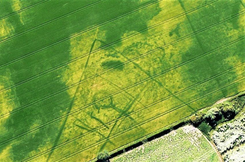
History from the air barrow cemetery at Arras, in East Yorkshire. Here,
burials were placed on the ground and a mound
One area where this has been used widely is the was built over them with soil dug out from a
Yorkshire Wolds, among the first to be covered in surrounding ditch. The barrow ditches show as
the National Mapping Programme undertaken by green squares. Dating from the Middle Iron Age,
the former Royal Commission on Historical probably around 300 BC, this site gave its name to
Monuments England, begun in 1908, now part of the internationally recognised Arras Culture of East
Historic England. Yorkshire.
Later Bronze Age earthworks known as Huggate Dykes,
from ground level. Credit: Peter Halkon, Author provided
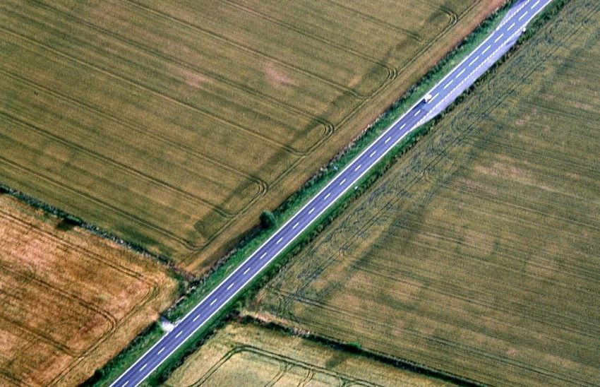
Cropmarks showing square barrows to either side of the
road at Arras, East Yorkshire. Credit: Peter Halkon,
Author provided
A portion of the massive later prehistoric
earthworks of Huggate Dykes has survived since
Compiled from thousands of aerial photographs by the banks and ditches were built in around 1000
Cathy Stoertz and published as Ancient BC, probably as territorial boundaries or as a
Landscapes of the Yorkshire Wolds in 1997, this means to control access to springs and streams.
remains one of the most detailed studies of an
archaeological landscape in the UK. From the River Impressive from ground level, an aerial view
Humber at Hessle to Flamborough Head, Stoertz's reveals faint green stripes in an adjacent cornfield –
mapping revealed a network of prehistoric and all that is left of the buried ditches after centuries of
Romano-British enclosures, burials mounds, ploughing.
ceremonial monuments and linear earthworks.
This year I have discovered hitherto unknown sites
My own research has examined many of these and, in other places, greater detail at already
sites on the ground through geophysical survey and recorded sites. These include Bronze Age round
excavation, and further aerial sorties, and this has barrows, apparent as rings in the crop, the
greatly expanded our knowledge of the region. characteristic square barrows of the Iron Age Arras
Flying from Hull Aero Club's airfield near Beverley, I Culture, and linear features running across the
have focused on the western escarpment of the landscape from Iron Age and Romano-British
Yorkshire Wolds and the eastern fringes at the Vale farmsteads and other settlements.
of York, a region I have studied for many years.
For example, the picture above shows the square
2/4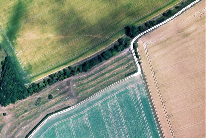
Seen from above, the remnants of the Huggate Dyke Soil marks of three Bronze Age round barrows on the
linear earthworks (centre) can be seen as faint green Yorkshire Wolds, appearing as circular marks in the soil.
stripes continuing into the adjacent field (top right). The darker circles show the infill of the ditch around the
Credit: Peter Halkon, Author provided barrow that was originally dug to create the barrow
mound. Credit: Peter Halkon, Author provided
Collaborating with Tony Hunt of Yorkshire Aerial
Archaeology and Mapping, for the first time I have
also used drones. Although these are subject to
altitude restrictions, a good quality camera on a
drone guided along pre-programmed tracks by
GPS can gather precise images. The hundreds of
overlapping images can be combined to provide a
huge two-dimensional mosaic image, or processed
to create 3-D imagery, an elevation model, or to
colourise the images in order to make the hidden
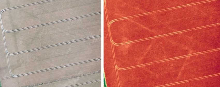
archaeological features more visible. Here, left, a conventional orthophoto of a field showing
the faint outline of an Iron Age or Romano-British square
This technique is truly revolutionary as mapping enclosure with the ditch of an associated droveway, and
was tricky and time-consuming in the past, right, the same site processed using the DroneDeploy
particularly aerial photographs taken at oblique Plant Health filter, adding false colour to better highlight
the archaeological features. Credit: Tony Hunt/Yorkshire
angles, requiring hours peering through a
Aerial Archaeology and Mapping, Author provided
stereoscope, mapping sites by hand using
geometry.
While the drought of 2018 has seriously affected
This article was originally published on The
crop yields, it has provided a rich harvest of a
Conversation. Read the original article.
different kind, one that will take a considerable time
to digest. An opportunity to do so will be as
archaeologists meet to discuss finds from across Provided by The Conversation
Europe at the Aerial Archaeology Research Group
annual conference, held this year in Venice,
September 12-14.
3/4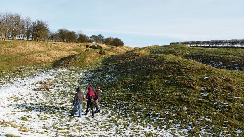
APA citation: Seen from the air, the dry summer reveals an ancient harvest of archaeological finds
                                   (2018, August 17) retrieved 17 July 2022 from https://phys.org/news/2018-08-air-summer-reveals-
                                   ancient-harvest.html

                                   This document is subject to copyright. Apart from any fair dealing for the purpose of private study or research, no
                                   part may be reproduced without the written permission. The content is provided for information purposes only.

                                                                                                                                                4/4

Powered by TCPDF (www.tcpdf.org)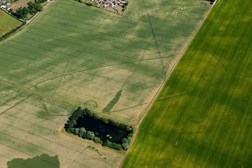

You can also read