SESE: Geography Donabate Portrane Educate Together NS - DPETNS
←
→
Page content transcription
If your browser does not render page correctly, please read the page content below
Donabate Portrane Educate Together NS

                             SESE: Geography                                                                   2018

 Introductory Statement
This Whole-School plan for Geography is the successor to our previous geography plan which was
formulated in 2010. The process of updating our plan was begun in 2017, when inputs were sought from all
teachers in deciding new priorities for the teaching of Geography.

 Rationale
 This plan was developed to provide a more coherent approach for staff in the teaching of Geography, with
 the ultimate goal of leading to improved learning outcomes for our children.

  Vision
 In Donabate Portrane ETNS, we afford the children enriched learning
 experiences through creative, progressive & innovative approaches in
 implementing the Primary Curriculum.
 In planning for Geography, we want to develop our children’s
 knowledge, skills and positive attitudes about places, people and
 issues. We start local and expand from there to eventually encompass
 the whole world. For our students, studying geography in D.P.E.T.N.S.
 should be an enjoyable, creative and stimulating experience.

 Aims
 Our primary aim in teaching Geography is to cultivate appreciation and respect in our children for the
 diversity and interdependence of living and non-living things. We believe that developing this respect will
 breed an interest and curiosity about the world, and a desire to understand and contribute positively to it
 through a variety of means.
 By encouraging our children to behave responsibly to protect, improve and cherish the environment at
 home here in Donabate/Portrane, we ultimately aspire to see them becoming agents for positive change
 in the broader world.

 The Aims of Geography Education are:
 • To develop knowledge and understanding of local, regional and wider environments and their
 interrelationships.
 •To encourage an understanding and appreciation of the variety of natural and human conditions on the Earth
 •To develop empathy with people from diverse environments and an understanding of human
 interdependence
 •To develop the ability to use a range of communication methods, especially those concerned with the
 development of graphicacy (mapping and other non-verbal, non-numerical forms of data presentation)
 •To encourage the development of a sense of place and spatial awareness
 •To encourage the development of caring attitudes and responsible behavior towards the environment, and
 the involvement in the identification, discussion, resolution and avoidance of environmental problems
 •To develop an understanding of appropriate geographical concepts.
                                                                                                               1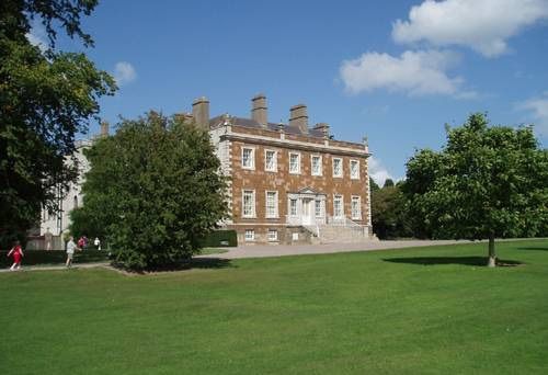
Donabate Portrane Educate Together NS

                           SESE: Geography                              2018

                           Layout of the Geography Policy

Section1: CurriculumPlanning
1.1: Strands/ Strand Units
1.2: Skills Development
1.3: Teacher Planning/ Preparation + Reporting
1.4: Children’s Ideas
1.5: Fieldwork & Practical Investigations
1.6: Classroom Management
1.7: Key Methodologies
1.8: Linkage/ Integration
1.9: ICT
2.0: Assessment
3.0: Children with Different Needs
4.0: Equality of Participation

Organisational Planning
5. Timetabling
6. Resources + Equipment
7. Safety
8. Homework
9. Staff Development
10. Parental Involvement
11. Community Links

Apendix
12. Country Menu, Class Topics & SESE Linkage

Success Criteria
      • Implementation
      • Ratification + Communication

                                                                        2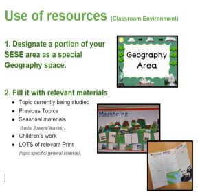
Donabate Portrane Educate Together NS

                                     SESE: Geography                                                                                             2018

 Section1: Curriculum Planning

 1.1 Strands/ Strand Units
Each year group has developed a unique SESE Plan that outlines in
detail which strands, strand units and content objectives will be studied
    • Content objectives have been allocated to each year group in such
        a way that appropriate development from class to class has been
        ensured.

   •    Thematic approaches are taken, with strong linkage between Geography, Science & History and
        integration with the school’s literacy plan.

 1.2 Skills Development
   •    Geographical skills development is treated with equal importance to content knowledge.
        We teach the following:
                                          A Sense of Placewhat it looks like when you’re teaching.

        The things that make Donabate/Portrane distinctive & special so that memories and emotions
        can be built up about it?
        Who lives here and what do they do? / Who works here and what do they do? / What facilities are there? / What is it like to be a child
        here? / What social strengths or problems does Donabate/Portrane have? / What events have happened here?

                                          A Sense of Spacewhat it looks like when you’re teaching.

        Locational information about where & why things are situated in relation to each other.
    ·   Knowing routes from place to place and visualizing what would be passed along the way. / Knowing that the Newbridge
        park is near the school and local housing estates so children can access it easily. / Realising that public bins are beside bus
        stops because of high need. /. Knowing what types of homes are in an area etc

                                                      Maps, Globes & Graphical Skills

    ·   Understanding, Using & Creating
    ·   A resource pack of maps are available in the school supplies.

                                                     Geographical Investigation Skills

                                      Questioning Observing Predicting Investigating & Experimenting
                                      Estimating & Measuring Analysing Recording & Communicating

                                                                                                                                                 3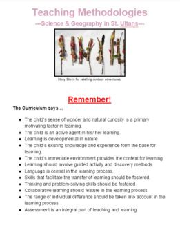
Donabate Portrane Educate Together NS

                              SESE: Geography                                                                       2018

1.3: Teacher Planning/ Preparation + Reporting
    •   Planning for Geography is done on a long & short term basis.
    •   Teachers plan in teams according to year group and share responsibilities amongst themselves in
        advance of lessons.
    •   Strands/ Strand Units/ Skills Development and Teaching Methodologies should be recorded on the
        monthly Cuntas Míosúil.

The following headings are necessary when planning for Geography:

                         Long Term                                   Short Term

1.4 Children’s Ideas
 In D.P.E.T.N.S., we recognise that the child’s initial ideas must be explored if they are to form a starting
 point for learning. This will help enormously to see what preconceived ideas the child may have. It is
 also useful as an assessment tool at the end of a unit to see if there has been any progression.
 Suggested approaches include:
 • Brainstorming + Concept Mapping
 • Questioning + Think, Pair, Share
 • KWL Charts + Before/ After drawings
 • Annotated drawings + Talk and discussion

                                                                                                                4
Donabate Portrane Educate Together NS
SESE: Geography 2018
1.5 Fieldwork & Practical Investigations
• We recognise that fieldwork is as a vital element of geographical education.
• We continue to strive for improvement and have decided to prioritise the
restructuring of our fieldwork programme for Geography in D.P.E.T.N.S. in 2018.
The new fieldwork guidelines will follow the structure of the PDST Guidelines for Fieldwork in Schools
and will include guidelines on the following activities:
Investigating human environments
• Observing and sketching features in the landscape.
• Conducting land use/ traffic surveys
• Effective use of Photographs Appropriate use of artifacts
• How to interview people living and working in the area
• How to conduct environmental appraisals
• Plotting routes on local maps.
Investigating Natural Environments
• Recognising and examining features in photographs
• Using simulations and models
• Observing and sketching features in the environment
• Conducting experiments and investigations
• Keeping a wildlife garden.
• Map skills and mapping concepts
• Local maps/ plans/ photographs & models
1.6 Classroom Management
A combined approach of whole-class work, small groups, paired work and individual work on chosen
topics and projects will be used in each class.
• Children will be given opportunities to work together collaboratively and share their own ideas.
• We encourage both the investigative approach and the teacher-directed approach.
5Donabate Portrane Educate Together NS
SESE: Geography 2018
1.7 Key Methodologies
The key methodologies of the Primary Curriculum are used as part of our Geography
programme (Use of the Environment/ Active learning/ Problem solving/ Developing skills through content/
Talk and discussion/ Co-operative learning).
• A booklet of suggested guidelines for using these methodologies in Geography &
Science lessons is available.
• Furthermore, we recognise the central role of imagery/ photography in teaching
Geography and so guidelines and examples to teachers on the specific ways in
which photographs may be used in the teaching of Geography in D.P.E.T.N.S.
• Project Based Learning is valued as a methodology in which children are
supported in solving their own questions through an array of curricular
subjects
• Learning through play is a valued methodology.
1.8 Linkage/ Integration
• A linked SESE approach can be taken to planning in which a topic may be developed through
the skills list of two or more of the SESE group as is suggested in this policy.
• The strand “Environmental Awareness & Care” and all associated strand units are shared
in both Geography & Science. This can be accounted for when planning as it covers both
subjects.
1.9: ICT
We recognise the many benefits of incorporating ICT into the Geography classroom.
• Interactive whiteboards and screens are in every classroom and are ideal for the
whole-class study of maps/ images, including route plotting, discovering change in areas over
time and accessing new & dynamic materials (documentaries, online tutorials).
• Teachers are advised to also make use of in-class computers and visualisers when developing
lessons.
• Specific websites we recommend for studying Geography include:
o Google Maps/ Earth
o Scoilnet.ie (which includes a free subscription to Britannica Online Encyclopedia)
o Askaboutireland.ie
o Youtube
6Donabate Portrane Educate Together NS
SESE: Geography 2018
2. Assessment
Geography Assessment is more than just a checklist of content-based facts. It’s a way of thinking that can
only be assessed by a teacher’s observation of how the children react to different situations. Teachers
should therefore employ a range of assessment techniques, including:
• Short, informal passages that put forward a teacher’s observations on the child’s development of
Skills & Attitudes.
• Strategic collection of work samples and child self-assessment to support observations.
3. Children with different needs
Our Geography teaching aims to meet the needs of all the children in the school.
• This will be achieved by teachers varying their pace, content and teaching methodologies to insure
learning for all pupils. This will be recorded in the teacher's yearly notes.
• The requirements of children with special needs will be taken into account when planning class
lessons and related activities.
• The SNA supports particular children and groups as directed by the class teacher.
4. Equality of Participation & Access
D.P.E.T.N.S. recognises and values diversity and that no child should be an insider and therefore believes
all children are entitled to access to the services, facilities, or amenities that are available in the school
environment.
Organisational Planning
5. Timetable
• SESE = 3 hours per week in full day classes / 2hrs 15mins in short day classes.
• Teachers may decide to allocate any or all of this time to Geography in any given week depending
on current workload and an awareness of the need for overall balance in the teaching of Science-
History-Geography.
6. Resources & Equipment
In-class resources should be:
1. Appropriate to the topic being studied.
2. Effective in helping students to understand & remember what’s being taught.
Such as:
• Annotated drawings
• Concept maps
• 3-Dimensional Objects
• Interactive displays
3. Presentation must be:
• Legible
• Tidy
• Cursive
7Donabate Portrane Educate Together NS
SESE: Geography 2018
Whole-School Resources
• Fieldwork resources available in school include: Clipboards, tape measures, magnifying glasses, bug
catchers/ viewers, metre sticks, compasses, thermometers, maps/ plans of the school & local area, weather
testing equipment.
• Materials + planning books are distributed to teachers in advance of each new term. Care of
distributed materials is charged to the lead teacher in each year stream. Materials should be
returned to the SESE store-room when they have been used.
• The SESE materials are stored at the end of the upstairs corridor and it holds a variety of
consumable materials (including foodstuffs/straws/ balloons/ card/ batteries etc).
7. Safety
During fieldwork, teachers should be aware of the safety implications of any work being undertaken
and children should be encouraged to observe safety procedures during all tasks.
The following is a summary of safety issues in the different strands of the curriculum:
• Outdoor work should be based in areas that are accessible and safe. A preliminary
visit by teachers should be used to identify any possible hazards.
• When working with plants and animals, pupils should wear gloves to protect from
allergic reactions.
• Children should wash their hands after handling animals, plants or soil.
• Cuts, grazes and skin infections should be covered.
• Prior to engaging in any outdoor work the children and teacher should discuss how they
will care for the animals and plants they may collect.
• Children should draw up their own conservation code before working in the
outdoor environment.
8. Homework
• Geography homework may be given, particularly when children are engaged in Project Based
Learning.
9. Staff Development
• External agencies are engaged with to provide CPD training in SESE.
• Internal staff development is provided to teaching staff at staff meetings.
10. Parental Involvement
• Parents with special relevant knowledge may be invited into school to speak to children.
• Parents and other adult members of the school community may be invited to assist with
certain activities,(Field Work, School Gardening).
11. Community Links
• DPETNS has built a strong working relationship with Donabate/Portrane Heritage group and
summer festival relating to our mutual interest in local environmental awareness and care.
• DPETNS has a good relationship with the OWLS. To date they have shared resources &
expertise.
• Groups/individuals in the community may be invited in to share their expertise about the location
and environment.
8Donabate Portrane Educate Together NS
SESE: Geography 2018
Appendix
12. Country Study Human Environments Natural Environments Environmental
(Suggestions for Awareness and Care
integration with
History)
Junior My Locality My Family and Weather Caring for my
Infants community The local locality –
Homes (in natural caring for my
Donabate and environment: classroom.
elsewhere) School
Other buildings grounds.
near the school Caring for my
(secondary locality
school,
community
centre)
Senior Donabate School (in Planet Earth in Caring for my
Infants Donabate and Space locality –
elsewhere) Caring for my caring for my
People at play locality school.
Journeys –
routes to
school,
transport in my
community
Pinpoint Dublin
on a map of
Ireland
1st Ireland People at work Trees in my Newbridge
Class Asian Country / (jobs) community Park – Animals
Countries My family and and in and Trees
(Afghanistan, community: Newbridge
Bangladesh, What Identifying
Cambodia, China, amenities / leaves
India, Japan, activities are Night & Day
Thailand, available locally and how their
Pakistan…) (local effects on
clubs/attractio plants and
ns) animals
Signposts in my
locality
9Donabate Portrane Educate Together NS
SESE: Geography 2018
2nd Mediterranean Donabate The local natural Caring for
Class Country / village – focus environment – Donabate –
Countries (Greece, on buildings, Newbridge House Litter
Italy, Malta, settlement, (gardens / forest area) Seaside safety
Cyprus) infrastructure, Irish Provinces and knowing
Russia mapping, At the seaside the sea.
services. in our Examining
Photographs community tides
(past and
present)
People and
places in other
areas
3rd Australasian People at work: Local beaches Re-using and
Class Country / Food and Coast & recycling
Countries Farming. Islands in our waste
(Australia, New The food we locality materials.
Zealand, Papua eat – Irish counties (project)
New Guinea, traceability. Plans & Maps Water Usage
Western Samoa, Transport Directions
Fiji…)
Scandinavian
Country /
Countries
(Norway, Sweden,
Finland)
4th North America / My County – Story of a Tidy Towns
Class Canada Origins & river Living in a
Eastern European geographical Rivers, Lakes community
Country / changes in Ireland
Countries (Estonia, (Norman The Water
Latvia, Lithuania, Ireland & Cycle
Ukraine…) Medieval
Ireland)
Irish Tourism
5th Great Britain Transport and Natural Farming in the
Class South American Communicatio Disasters – local
Country / n Volcanoes, community
Countries (Cuba, People at work: Earthquakes and Ireland
Brazil, Chile, Tourism etc The Fishing
Argentina) (Airport / local Longitude & Industry
factory/wareho Latitude, Co-
use) ordinates
Mountain
ranges in
Ireland
Rocks & Soils
10Donabate Portrane Educate Together NS
SESE: Geography 2018
6th African Country / Trade and The structure of the The Burren
Class Countries (Nigeria, development earth
Niger, Benin, issues (famine) Energy
Egypt, South Peatlands of Ireland (Renewable and Non-
Africa…) Modern (Bórd na Mona) renewable)
Western European industry in
Country / Ireland Ordnance Survey Storms, Weather and
Countries (France, (Industrial Mapping Disasters.
Spain, Germany, Revolution)
Portugal,
Switzerland,
Holland, Austria…)
Success Criteria
Implementation
• Class teachers are responsible for implementing the Geography Plan in their own classes.
• The SESE Post Holder liaises with outside agencies/ develops policy/ coordinates resources and
spearheads Geography events in the school.
• Members of the SESE committee collaborate in developing geography policy/managing
resources and coordinating Geography events.
Ratification & Communication
Ratification will be completed at Board level.
• The ratified Whole-School Policy for Geography will be available to all teacher on school
network.
• Teachers will be briefed about the policy.
11You can also read


