SOUTH WEST PACIFIC HYDROGRAPHIC COMMISSION INTERNATIONAL CHARTING COORDINATION WORKING GROUP (SWPHC ICCWG) - Report for SWPHC 18
←
→
Page content transcription
If your browser does not render page correctly, please read the page content below
SOUTH WEST PACIFIC HYDROGRAPHIC
          COMMISSION

INTERNATIONAL CHARTING COORDINATION
          WORKING GROUP
           (SWPHC ICCWG)

          Report for SWPHC 18
            17th – 19th Feb 2021, VTC

             Chair: Mr Robert Cario
          Australian Hydrographic Office

          robert.cario@defence.gov.au

                        1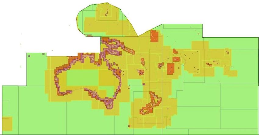
Background
The SWPHC ICCWG was established in 2012 as a subsidiary of the SWPHC. It is made up
of Producer Nations who publish Paper chart and ENCs in the SWPHC geographic area.
Its main responsibility is for the coordination of Nautical Charting in the region, ensuring the
Paper Chart INT series is comprehensive and current and the ENC coverage is appropriate.
The main focus is on paper Charts at 1:500,000 and smaller and ENC Nav Purpose 1 and 2
coverage.
The group operates as a correspondence group.

Current SWPHC ICCWG Members
Australia (chair) Robert Cario – robert.cario@defence.gov.au
France - Nicolas David - nicolas.david@shom.fr
New Zealand - Rachel Gabara - rgabara@linz.govt.nz
UK - Lee Truscott - lee.truscott@ukho.gov.uk
USA (NOAA) - Sydney Catoire - sydney.catoire@noaa.gov
USA (NGA) - Rachel Janes - rachel.r.janes@nga.mil

SWP Countries and their Charting Producer Nations
SWPHC nations                        Primary Charting Authority (PCA)

SWPHC Members:

Australia                            Australia
Fiji                                 UK
France                               France
New Zealand                          New Zealand
Papua New Guinea                     Australia
Samoa                                New Zealand
Solomon Islands                      Australia
Tonga                                New Zealand
UK                                   UK
USA                                  USA
Vanuatu                              UK

Associate Members:

Cook Islands                         New Zealand
Indonesia                            Indonesia
Kiribati                             UK
Nauru                                UK
Niue                                 New Zealand
Palau                                USA

                                               2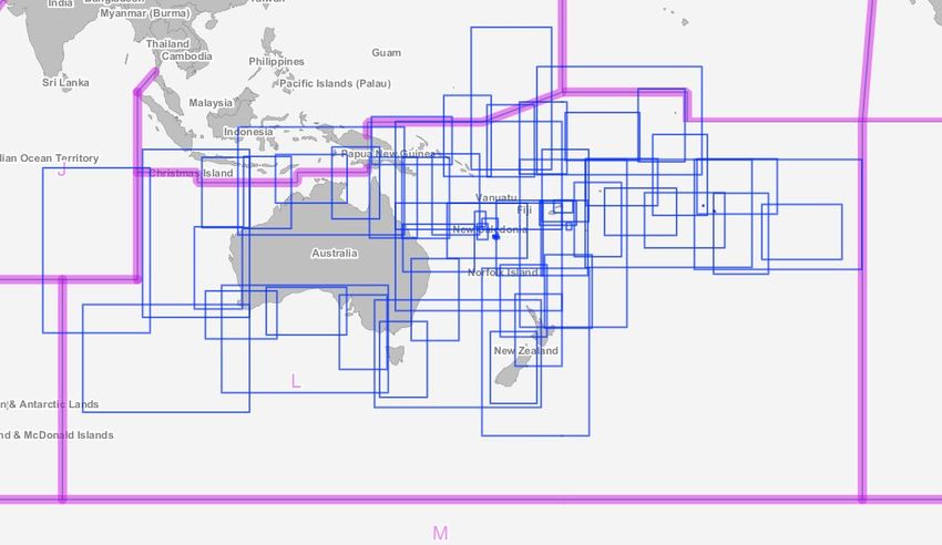
SWPHC Observer:

New Caledonia                         France

Intergovernmental Observer Organization:

Secretariat of the Pacific Community (SPC)

Fed States of Micronesia              USA
Marshall Islands                      USA
American Samoa                        USA
Pitcairn Islands                      UK
Guam                                  USA
French Polynesia                      France
Northern Mariana Islands              USA
Tokelau                               New Zealand
Tuvalu                                UK
Wallis and Futuna                     France

S-11 Part B, Region L updates
Updates are now managed through INTernational Chart Web Manager

Paper INT charts produced since the last conference:
UKHO
UKHO has produced the following isogonal new editions.
 GB         Title                                             Published        ENC
 Chart
 Number
 4624       Pacific Ocean – Santa Cruz Island to Butaritari   10th September   GB204624
 (INT624)                                                     2020
 4632       South Pacific Ocean – Fiji to Tuvalu              10th September   GB24632E
 (INT632)                                                     2020
 4633       Pacific Ocean – Solomon Islands to Fiji           10th September   GB204633
 (INT633)                                                     2020
 4637       South Pacific Ocean – Vanuatu to Norfolk          10th September   GB204637
 (INT637)   Island                                            2020

                                                3
Nav Purpose 1 and 2 ENC produced since last conference:
The US National Geospatial-Intelligence Agency (US NGA) and US National Oceanic and
Atmospheric Administration (US NOAA) took responsibility for six UK Hydrographic
Office (UKHO) ENCs. The UKHO provided the unencrypted GB ENCs to the US for
internal reference purposes to enable production of replacement products in the region. The
six US ENCs were released as a set and UKHO simultaneously cancelled their ENCs in
October 2020.
Table below represents the following cells transferred:
Previous ENC Name Current ENC Name Scale Ownership
GB203552 US2SP02M 1:1,500,000 US NOAA
GB200764 US2SP03M 1:1,500,000 US NOAA
GB200763 US2FAS01 1:1,500,000 US NGA
GB200762 US2FAS02 1:1,500,000 US NGA
GB200761 US2FAS03 1:1,500,000 US NGA
GB204623 US2FAS03 1:1,500,000 US NGA
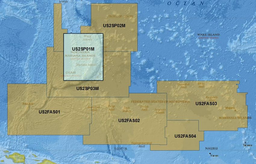
Figure 1: UKHO Nav Purpose 2 ENCs transferred to US NGA/NOAA
4INT Charts and 1 & 2 ENC underway:
SHOM
On French waters around New Caledonia, SHOM is producing a chain at scale 1:300000.
FR6686 (INT6843) Nouvelle-Calédonie (partie Sud-Est) - Iles Loyauté and FR6768
(INT6844) - Nouvelle-Calédonie (partie Sud) - Ile des Pins - expected to be published in
2021 and 2022.
Shom plan to produce new FR272680 (based on paper chart FR7268) and reduce FR273210.
AHO
Small scale ENC project is currently underway to update all region L Overview and General
usage ENC’s - AU130060, AU130090, AU130120, AU130150, AU160060, AU160090,
AU160120 and AU160150 and corresponding AU2 cells are being updated to current
specifications, updated isogonals and generalisation of coastal data.
Proposals for New INT Charts
LINZ
LINZ are still waiting to make a decision about withdrawing paper chart NZ 14630 (INT
630) as withdrawing this chart in contingent on some other factors.
NOAA/NGA
Paper INT Chart Update:
NOAA is undertaking a five-year program to end all raster and paper nautical chart
production. Ultimately, production of all NOAA paper nautical charts (including paper INT
charts), raster navigational charts (NOAA RNC®), and related products will cease.
Nav Purpose 1 and 2 ENC Updates:
NOAA’s Office of Coast Survey is in the process of rescheming its ENC suite. Current ENC
boundaries are based on the paper nautical chart extents but will transition to a rectangular
grid following latitude and longitude lines. Additionally, reschemed ENCs will have a
standardized size with two scales per usage band. Table below pertains to Nav Purpose 1 and
Nav Purpose 2 reschemed ENCs.
The figures below represent the current NOAA and NGA ENC boundaries (red) and future
NOAA reschemed ENCs (blue) for Nav Purpose 2 in Region L. The Nav Purpose 1 NOAA
5reschemed ENC plan has not been created. Additionally, NGA is in the process of creating a
separate ENC grid for use in building its future ENC portfolio. NOAA plans to coordinate
with other Hydrographic Offices and use a CATCOV solution to prevent ENC overlap.
Figure 2: US current ENCs (outlined in red) with planned Nav Purpose 2 reschemed ENCs
(outlined in blue).
6Figure 3: US current ENCs (outlined in red) with planned Nav Purpose 2 reschemed ENCs
(outlined in blue)
7AHO
A review is currently underway regarding future requirements for INT paper nautical charts.
A number of INT charts have been identified as suitable for withdrawal without replacement.
The intention is that, for most areas, coverage will remain available at 1:3.5M only. One
1:10M and one 1:1.5M chart are likely to remain from within the existing portfolio. The
intention is that remaining INT paper charts will be the minimum necessary to:
i.Facilitate route planning and monitoring in areas not fully covered by the coastal
series (e.g. offshore reefs, neighbouring countries and Antarctica).
ii.Display maritime claims (EEZ and Continental Shelf limits).
The INT chart withdrawal program is scheduled for completion by end of 2021.
Proposed AHO INT
Chart Scheme:
• 1:3 500 000 – Green
• 1:1 500 000 – Pink
• 1:10 000 000 – Blue
Figure 4: Proposed AUS INT paper chart reschemed.
8Current ENC – Nav Purpose 1 - Overview
9Current ENC – Nav Purpose 2 - General
10Current INT Paper charts in SWPHC
l
11Overlaps of Navigation Purpose 1 and 2 ENC cells in SWP
• The following is an extract from a report received from IC-ENC regarding overlaps of ENC in the SWP. Further details can be provided by
contacting the ICCWG Chair.
IC-ENC REGIONAL HYDROGRAPHIC COMMISSION OVERLAP REPORT - SOUTH WEST PACIFIC RHC - FEBRUARY 2021
Overlap extent
RENC Usage ENC 1 ENC 2 ENC 1 ENC 2 Content Geog. Shipping Route Overall Severity
STATUS RHC ENC 1 ENC 2 (Kmxkm) Size Scale ECDIS Justification
Membership Band Scale Scale Version Version difference Location density patterns of Risk
(m/square NM)
Overlap is located in the Antartica, it charts very deep waters. There is a 119m shoal
840Km x 558Km
LIVE IC-ENC SWPHC/HCA RU1B0PF0 AU160060 1 3000000 3500000 1 (0) 4 (0) LOW LOW LOW LOW LOW LOW MEDIUM LOW depth which is captured on AU160000 which is not captured on RU1B0PF0. Little
135600 sq. NM
traffic as expected.
560Km x 1700Km Overlap is located in the Antartica, it charts very deep waters. Little traffic as
LIVE IC-ENC SWPHC/HCA RU1B0PF0 AU160090 1 3000000 3500000 1 (0) 3 (1) LOW LOW LOW LOW LOW LOW MEDIUM LOW
273008 sq. NM expected.
560Km x 195Km Overlap is located in the Antartica, it charts very deep waters. Little traffic as
LIVE IC-ENC SWPHC/HCA RU1B0PF0 AU160120 1 3000000 3500000 1 (0) 3 (4) LOW LOW LOW LOW LOW LOW MEDIUM LOW
31605 sq. NM expected.
SWPHC17 Actions
Nil
12Engagement with Non Producer Nations in SWP
Within the South West Pacific, the Producer Nations of New Zealand, UK, France and Australia
have reported good working relationships with the Hydrographic Offices / National Maritime
jurisdictions and/or Governments of the countries they chart.
Australia attends the annual Papua New Guinea National Maritime Safety Authority (PNG NMSA)
planning meeting to discuss with PNG NMSA and Port and Shipping Company representatives their
charting requirements and priorities. Australia has initiated a similar arrangement with Solomon
Islands to discuss Charting priorities and survey requirements on an annual basis and attended
meetings with SIMA in September 2019 however due to COVID 19 restrictions no meeting took
place in 2020.
Adherence to WEND principles
ENCs are distributed worldwide via the following mechanisms:
Producer nation Mechanism
France PRIMAR RENC
Australia IC-ENC RENC
New Zealand IC-ENC RENC
UK IC-ENC RENC
US IC-ENC RENC
Recommendations for discussion at SWPHC 18
1. Members of the SWPHC note this report.
13You can also read