State Examinations Commission - Coimisiún na Scrúduithe Stáit Leaving Certificate 2018 Marking Scheme Geography Higher Level - Studyclix
←
→
Page content transcription
If your browser does not render page correctly, please read the page content below

HL cover 2 colour v9.qxp_BOOKS CVR SETUPS EV 01/08/2018 14:43 Page 1

                         Coimisiún na Scrúduithe Stáit
                         State Examinations Commission

                                 Leaving Certificate 2018

                                             Marking Scheme

                                                     Geography

                                                   Higher Level
Note to teachers and students on the use of published marking schemes
Marking schemes published by the State Examinations Commission are not intended to be
standalone documents. They are an essential resource for examiners who receive training
in the correct interpretation and application of the scheme. This training involves, among
other things, marking samples of student work and discussing the marks awarded, so as to
clarify the correct application of the scheme. The work of examiners is subsequently
monitored by Advising Examiners to ensure consistent and accurate application of the
marking scheme. This process is overseen by the Chief Examiner, usually assisted by a Chief
Advising Examiner. The Chief Examiner is the final authority regarding whether or not the
marking scheme has been correctly applied to any piece of candidate work.

Marking schemes are working documents. While a draft marking scheme is prepared in
advance of the examination, the scheme is not finalised until examiners have applied it to
candidates’ work and the feedback from all examiners has been collated and considered in
light of the full range of responses of candidates, the overall level of difficulty of the
examination and the need to maintain consistency in standards from year to year. This
published document contains the finalised scheme, as it was applied to all candidates’ work.

In the case of marking schemes that include model solutions or answers, it should be noted
that these are not intended to be exhaustive. Variations and alternatives may also be
acceptable. Examiners must consider all answers on their merits, and will have consulted
with their Advising Examiners when in doubt.

Future Marking Schemes

Assumptions about future marking schemes on the basis of past schemes should be
avoided. While the underlying assessment principles remain the same, the details of the
marking of a particular type of question may change in the context of the contribution of
that question to the overall examination in a given year. The Chief Examiner in any given
year has the responsibility to determine how best to ensure the fair and accurate
assessment of candidates’ work and to ensure consistency in the standard of the
assessment from year to year. Accordingly, aspects of the structure, detail and application
of the marking scheme for a particular examination are subject to change from one year to
the next without notice.
In considering this marking scheme, the following should be noted:

   •   The detail required in any answer is determined by the context and the manner in which
       the question is asked and by the number of marks assigned to the answer in the
       examination paper.
   •   Words, expressions or phrases must be correctly used in context and not contradicted, and
       where there is evidence of incorrect use or contradiction, the marks may not be awarded.
   •   As a general rule, if in doubt about the validity of any answer, examiners must consult their
       advising examiner before awarding marks.
   •   The suggestions, examples etc. in the scheme are not exhaustive and alternative valid
       answers etc. are acceptable.
   •   For the purpose of marking a Significant Relevant Point (SRP) is a single piece of factual
       information, to which an examiner will assign a mark weighting as prescribed in the
       marking scheme (typically 2 marks). As previously advised in Circular S85/09 and in the
       Sample Marking Indicators available on the SEC website each SRP should emerge from the
       information put forward by the candidate, leading to an overall coherent response to the
       question.

                                                 1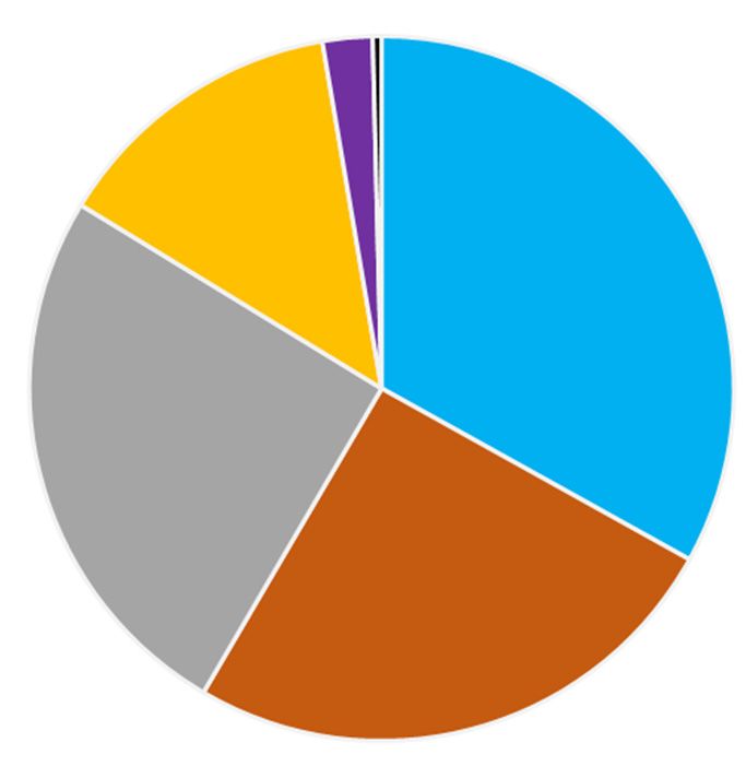
PART ONE – SHORT ANSWER QUESTIONS
                        Award any 10 questions @ 8 marks each.
      Mark all questions attempted and award the 10 questions with highest mark.
                                     No grading.
Q.1    (i)      Plateau                   1m    Q.7(i)    B                        1m
                Dendritic                 1m              A                        1m
                Trellised                 1m              D                        1m
                Swallow hole              1m              C                        1m
                                                Q.7(ii)   W                        1m
       (ii)     Any valid answer          2m              Y                        1m
       (iii)    Ribbon/Paternoster lake   2m              Z                        1m
                                                          X                        1m
Q.2    (i)      A Left Foreground         2m    Q.8(i)    B                        1m
                B Centre Middleground     2m              C                        1m
                C Right Background        2m              A                        1m
                                                Q.8(ii)   Compression              1m
       (ii)     Oblique                   2m              Shearing                 1m
                                                          Tension                  1m
Q.3    (i)      False                     1m    Q.8(iii) True                      2m
       (ii)     False                     1m    Q.9(i) F                           1m
       (iii)    False                     1m             E                         1m
       (iv)     True                      1m             A                         1m
       (v)      False                     1m             C                         1m
       (vi)     True or false             1m             B                         1m
       (vii)    False                     1m             D                         1m
       (viii)   True                      1m    Q.9(ii) True                       2m
Q.4    (i)      597 (m)                   2m    Q.10     (i) 998 (mb)              2m
       (ii)     G 685 365 / G 692 362      2m            (ii) Occluded             2m
       (iii)    1.5 (km)                  2m              (iii) 1028 (mb)          2m
        (iv) 42 (km2) approx.              2m             (iv) False           2m
Q.5(i) Geomorphological                   1m    Q.11      (i) 2 reasons      1m + 1m
        Administrative                    1m              (ii) Valid ans.       2m
        Peripheral                        1m              (iii) 515             2m
        Cultural                          1m              (iv) Valid ans.    1m + 1m
Q.5(ii) The Burren                        1m
        Co. Wexford                       1m
        Northern Norway                   1m    Q.12      (i) Czech Rep         2m
        Islamic world                     1m              (ii) Germany          2m
Q.6     (i)    A. North American           1m             (iii) 4               2m
               B. African                 1m              (iv) Valid ans.     1m + 1m
        (ii)   South American              1m
               Nazca                      1m
        (iii) Pacific Ring of Fire        2m
        (iv) Constructive/Divergent       2m

                                                  2
PART TWO – STRUCTURED and ESSAY QUESTIONS – 320 MARKS
You must attempt FOUR questions, as follows:
• TWO questions from Section 1 – Core:
One question from Questions 1, 2 and 3 (80 marks)
AND
One question from Questions 4, 5 and 6 (80 marks)
• ONE question from Section 2 – Electives (80 marks)
• ONE question from Section 3 – Options (80 marks)
THESE QUESTIONS ARE TO BE ANSWERED IN THE ANSWER BOOK
SECTION 1 – CORE
Questions 1 to 6
You MUST attempt TWO questions:
ONE from Patterns and Processes in the Physical Environment (Questions 1 to 3)
AND
ONE from Regional Geography (Questions 4 to 6)
All questions carry 80 marks.
3PATTERNS AND PROCESSES IN THE PHYSICAL ENVIRONMENT
Questions 1 to 3
Attempt ONE question
Question 1
1A. Karst Landscape
C
B
D
Ground
Water A
Table Limestone
Amended from www.geojackdouglas.blogspot.com
Examine the diagram above and answer each of the following questions.
(i) Name each of the features labelled A and B.
(ii) What is the term given to the horizontal lines at C found in limestone?
(iii) What is the term given to the vertical lines at D found in limestone?
(iv) Name any two processes of chemical weathering.
(v) Explain briefly one of the processes of chemical weathering named by you above.
(vi) Explain briefly what is meant by the ground water table.
[20m]
(i) A = Stalagmite 2m
B = Stalactite 2m
(ii) Bedding plane 2m
(iii) Joint 2m
(iv) Two valid processes 2m + 2m
(v) Valid brief explanation 2m + 2m
(vi) Valid brief explanation 2m + 2m
41B. Isostasy
Describe and explain how isostasy impacts on the coastal landscape or on the fluvial
landscape.
[30m]
Impact identified 2m
Description/Explanation 14 x SRP’s
Credit second and third impact identified for 2 x SRP’s from description/explanation.
All further impacts require examination.
Credit one named specific example for 1 x SRP from description/explanation.
Credit relevant labelled diagram for 1 x SRP. Diagram without labelling 0 marks.
Credit additional relevant information on a labelled diagram for 2 x SRP’s. This must
be information not already awarded in the written account.
Information awarded on a diagram if presented must be valid and relevant to the set
question.
If impact of isostasy on both coastal and fluvial landscape discussed, mark both
separately and award the highest mark.
Question is not tied to Ireland.
Max 2 x SRP’s if merely a description of isostasy with no reference to impact on
landscape.
1C. Volcanoes
Discuss the positive impacts of volcanoes.
[30m]
Positive impacts identified 2m + 2m
Discussion 13 x SRP’s
Credit a third positive impact identified for 1 x SRP from discussion. All other positive
impacts require discussion.
Credit one named volcano / volcanic area from discussion for 1 x SRP.
Credit relevant labelled diagram for 1 x SRP. Diagram without labelling 0 marks.
Credit additional relevant information on a labelled diagram for 2 x SRP’s. This must
be information not already awarded in the written account.
Information awarded on a diagram if presented must be valid and relevant to the set
question.
If only negative impacts are discussed 0 marks.
5Question 2
2A. Structure of the Earth
B
Crust A
C
2900 km
Core
6378 km
Amended from www.wiki.seg.org
Examine the diagram above and answer each of the following questions.
(i) Name each of the layers of the earth labelled A, B and C.
(ii) Name the two main minerals found in the core.
(iii) What is the name given to the boundary between the crust and the mantle?
(iv) Explain briefly how plates move.
(v) Explain briefly what is meant by endogenic forces.
[20m]
(i) A = Asthenosphere 2m
B = Lithosphere 2m
C = Mantle 2m
(ii) Iron 2m
Nickel 2m
(iii) Moho discontinuity 2m
(iv) Valid brief explanation 2m + 2m
(v) Valid brief explanation 2m + 2m
62B. Weathering
Explain the role of temperature in the process of physical/mechanical weathering.
[30m]
Reference to temperature 2m
Explanation 14 x SRP’s
Credit second reference to temperature for 1 x SRP. All further references to
temperature require explanation.
Credit relevant processes of physical/mechanical weathering named for 2 x SRP’s. All
further processes of physical/mechanical weathering require explanation.
Credit relevant labelled diagram for 1 x SRP. Diagram without labelling 0 marks.
Credit additional relevant information on a labelled diagram for 2 x SRP’s. This must
be information not already awarded in the written account.
Information awarded on a diagram if presented must be valid and relevant to the set
question.
2C. Surface Processes
Examine the 1:50 000 Ordnance Survey map and legend accompanying this paper.
Answer (i) or (ii).
(i) Name and identify using six-figure grid references, two features on the map that
have been formed by glacial processes, coastal processes or fluvial processes.
Explain the formation of any one of these features.
Features named 2m + 2m
Grid references 2m + 2m
Explanation of formation of one feature 11 x SRP’s
Credit relevant surface process identified for 1 x SRP. All further processes
require explanation and explanation must tie to formation of landform to
merit SRP.
Credit relevant labelled diagram for 1 x SRP. Diagram without labelling 0
marks.
Credit additional relevant information on a labelled diagram for 2 x SRP’s.
This must be information not already awarded in the written account.
Information awarded on a diagram if presented must be valid and relevant
to the set question.
Max 2 x SRP’s if merely a description of landform with no explanation of
formation.
or
7(ii) Using grid references, identify an area on the map which has a very steep slope
and identify an area on the map which has a very gentle slope.
Describe and explain any one mass movement process that might operate in areas
such as these.
[30m]
Grid references 2m + 2m
Mass movement process named 2m
Description/Explanation 12 x SRP’s
Credit relevant labelled diagram for 1 x SRP. Diagram without labelling
0 marks.
Credit additional relevant information on a labelled diagram for 2 x SRP’s.
This must be information not already awarded in the written account.
Information awarded on a diagram if presented must be valid and relevant
to the set question.
8Question 3
3A. Ordnance Survey Map
Examine the 1:50 000 Ordnance Survey map and legend accompanying this paper.
Draw a sketch map of the area shown to half scale.
On it, correctly show and label each of the following:
• The entire course of the Drumcliff River
• Two named lakes
• The entire area of land above 300 metres south of northing 43.
[20m]
Sketch Outline 4 marks (4/0)
4 features @ 4 marks each: Shown 3 marks (graded 3/1/0)
Label 1 mark
Sketch outline must be drawn to half scale of the prescribed area. Required size is
12 cm x 9 cm [allow a difference of up to 0.5cm].
The sketch must have four sides drawn. Using the edge of the page is not acceptable.
Lose 4 marks for sketch outline.
If sketch is traced or only a section of the map is drawn, lose 4 marks for sketch outline
and lose 3 marks for showing per item. Allow labelling marks only.
If the aerial photograph is used instead of the Ordnance Survey map 0 marks.
The features may be labelled on the sketch or in a key. If not labelled, 0 marks for
showing.
There must be an attempt to show feature for labelling marks to be awarded. If not
shown, 0 marks for labelling. If located incorrectly but labelled correctly, labelling
marks can be awarded as there has been an attempt to locate it.
Showing marks graded 3/1/0. Reasonable accuracy (location and proportion) for full
showing marks.
If there is no attempt to draw the coastline, deduct 2 marks from the total mark.
Sketch may be drawn in the answer book or on graph paper.
93B. Human Interaction with the Rock Cycle
Humans interact with the rock cycle in a number of ways.
Describe and explain how this interaction with the rock cycle takes place, with reference to
one of the following:
• Mining
• Extracting building materials
• Oil/gas exploitation
• Geothermal energy production.
[30m]
Description/Explanation 15 x SRP’s
Credit 2 x SRP’s for named specific examples. Examples may be a named company,
location etc.
Credit relevant labelled diagram for 1 x SRP. Diagram without labelling 0 marks.
Credit additional relevant information on a labelled diagram for 2 x SRP’s. This must
be information not already awarded in the written account.
Information awarded on a diagram if presented must be valid and relevant to the set
question.
Question is not tied to Ireland.
Discussion may be positive or negative.
3C. Plate Boundaries
Describe and explain destructive plate boundaries.
[30m]
Description/Explanation 15 x SRP’s
Credit 3 x SRP’s for locational examples from description/explanation.
Credit 2 x SRP’s for identifying the type of destructive plate boundary from
description/explanation.
Max 8 x SRP’s if merely a description of plate boundaries with no reference to
explanation.
Question requires discussion of destructive plate boundaries. Do not award marks
for discussion of constructive or neutral plate boundaries.
Credit relevant labelled diagram for 1 x SRP. Diagram without labelling 0 marks.
Credit additional relevant information on a labelled diagram for 2 x SRP’s. This must
be information not already awarded in the written account.
Information awarded on a diagram if presented must be valid and relevant to the set
question.
10REGIONAL GEOGRAPHY
Questions 4 to 6
Attempt ONE question.
Question 4
4A. Map Skills
Draw an outline map of an Irish region that you have studied.
On it, show and name each of the following:
• A named river
• The outline of a named feature of relief (upland or lowland)
• Two named urban centres.
[20m]
Map outline 4 marks graded (4/2/0)
4 features @ 4 marks each Shown 2 marks graded (2/1/0)
Named 2 marks
Do not accept an outline map a European or Continental / Sub-continental region.
Accept any valid type of urban centre irrespective of size.
Outline map may be drawn in the answer book or on graph paper.
Names may be written on the sketch map or in a key.
Credit marks for naming of required features if names are valid and correct even if
features are not shown or are shown incorrectly.
Where features are shown but named incorrectly or not named at all, then 0 marks for
showing and 0 marks for naming.
114B. Concept of a Region
Examine how culture can be used to define regions, with reference to example(s) that you
have studied.
[30m]
Aspect of culture identified 2m
Example of a region defined by culture 2m
Examination 13 x SRP’s
Credit second aspect of culture identified for 1 x SRP. All further aspects must be
examined.
Credit second example of a region defined by culture for 1 x SRP.
Accept a broad definition of culture.
Credit a valid labelled sketch map for 1 x SRP from examination.
Credit additional relevant information on the sketch map for a further 1 x SRP. This
must be information not already awarded in the written account.
Information awarded on a sketch map if presented must be valid and relevant to the
set question.
4C. Primary Economic Activity – Agriculture
Explain the impact of climate on the development of agriculture in two contrasting
European regions (not in Ireland) that you have studied.
[30m]
Explanation Region 1 7/8 x SRP’s
Explanation Region 2 7/8 x SRP’s
Credit 1 x SRP per region for identification of the impact of climate on the
development of agriculture. All further impacts require explanation.
Credit 1 x SRP per region for a specific example of agriculture.
Where the development of agriculture is discussed with no reference to climate
max 1 x SRP per region.
Where climate is discussed with no reference to its impact on the development of
agriculture max 1 x SRP per region.
If only one region discussed max 8 x SRP’s.
Credit a valid labelled sketch map for 1 x SRP from examination.
Credit additional relevant information on the sketch map for a further 1 x SRP. This
must be information not already awarded in the written account.
Information awarded on a sketch map if presented must be valid and relevant to the
set question.
Do not accept Irish or Continental / Sub-Continental regions.
Positive or negative interpretation of development is acceptable.
12Question 5
5A. Population Dynamics
European Union First Time Asylum Applicants 2016
Other
X Syria
29%
Pakistan Albania
4% 2%
Russia
Nigeria 2%
4%
Eritrea Afghanistan
3% Iraq 16%
11% Amended from Eurostat
Examine the chart above showing the country of origin of first time asylum applicants to
the European Union (EU) in 2016 and answer each of the following questions.
(i) Name the two countries that had the highest percentage of first time asylum
applicants to the EU in 2016.
(ii) Explain briefly one reason why European Union member states are attractive
destinations for asylum applicants.
(iii) Calculate X, the percentage of first time asylum applicants in the category of Other
country of origin.
(iv) Explain briefly two challenges faced by EU member states due to the large number
of people seeking asylum in the EU.
[20m]
(i) Syria 2m
Afghanistan 2m
(ii) Valid brief explanation 2m + 2m
(iii) 29(%) 4m
(iv) Two valid brief explanations 2m + 2m
2m + 2m
135B. Tertiary Economic Activity
Account for the development of tourism or transport in a Continental / Sub-Continental
region (not in Europe) that you have studied.
[30m]
Examination 15 x SRP’s
Credit factors influencing the development of transport or tourism for 2 x SRP’s from
examination. All further factors require examination.
Credit 2 x SRP’s for specific examples of transport or tourism.
Max 2 x SRP’s if merely a description of transport or tourism with no examination of
its development.
Where two separate accounts in relation to the development of transport and
tourism are presented mark both separately and award the highest mark.
However, accept discussion of transport within tourism if the discussion of transport
is relevant to the development of tourism. Similarly, accept discussion of tourism
within transport if the discussion of tourism is relevant to the development of
transport.
Credit a valid labelled sketch map for 1 x SRP from examination.
Credit additional relevant information on the sketch map for a further 1 x SRP. This
must be information not already awarded in the written account.
Information awarded on a sketch map if presented must be valid and relevant to the
set question.
Positive or negative interpretation of development is acceptable.
Do not accept European or Irish region.
Examination without reference to named or clearly inferred region 0 marks.
145C. Secondary Economic Activity
Examine the impact of each of the following on the development of secondary economic
activity in an Irish region that you have studied:
• Raw materials
• Markets.
[30m]
Discussion of Factor 1 7/8 x SRP’s
Discussion of Factor 2 7/8 x SRP’s
Credit 1 x SRP per factor for identifying the impact of the raw materials/market on
the development of secondary economic activity.
Credit 2 x SRP’s for specific examples of secondary economic activity.
Do not accept European or Continental / Sub-Continental region.
Discussion without link to a named region or clearly inferred region 0 marks.
Credit a valid labelled sketch map for 1 x SRP from examination.
Credit additional relevant information on the sketch map for a further 1 x SRP. This
must be information not already awarded in the written account.
Information awarded on a sketch map if presented must be valid and relevant to the
set question.
Positive and negative interpretation of development is acceptable.
Max 1 x SRP’s per factor if merely a description of the factor with no reference to the
development of secondary economic activity.
Max 8 x SRP’s if only one factor discussed.
15Question 6
6A. Complexity of Regions
Number of Daily Irish Speakers in Selected Gaeltacht Areas
2011 and 2016
Gaeltacht Area 2011 2016
County Kerry 2500 2000
County Donegal 7000 5900
County Mayo 1100 900
Amended from CSO
Examine the table above and answer each of the following questions.
(i) Using graph paper, draw a suitable graph to illustrate this data.
Bar Chart Pie Chart
Title 2 marks 2 marks
Vertical axis named 1 mark 1 + 1 mark (Circle & Centred)
Horizontal axis named 1 mark
6 items illustrated 2 marks each graded (2/1/0) 2 marks each graded (2/1/0)
Accept any suitable graph / chart.
Naming of graph / chart type is not sufficient for title marks. The title must have
reference to chart content and it can be written anywhere on the graph.
If graph paper is not used deduct 2 marks from total.
Apply the 2 marks graded if the numbered spaces and the column widths are not
plotted accurately.
(ii) Explain briefly one strategy that could be used to address the decline in the number
of daily Irish speakers in Gaeltacht areas.
[20m]
Any valid brief explanation 2m + 2m
166B. Urban Development
Examine the factors that have influenced the development of one urban area in a
Continental / Sub-Continental region (not in Europe) that you have studied.
[30m]
Urban area named 2m
Factors identified 2m + 2m
Examination 12 x SRP’s
Credit a third factor identified for 1 x SRP from examination. All further factors
require examination.
Do not accept an urban area in a European or Irish region.
Accept any valid type of urban area or part there of irrespective of size.
Discussion without reference to a named or clearly inferred urban area 0 marks.
Examination can be based on positive or negative interpretation of development.
Credit a valid labelled sketch map for 1 x SRP from examination.
Credit additional relevant information on the sketch map for a further 1 x SRP. This
must be information not already awarded in the written account.
Information awarded on a sketch map if presented must be valid and relevant to
the set question.
Development of the urban area can be positive or negative.
6C. European Union
Discuss the potential challenges facing the future development of the European Union with
reference to factors such as political union, economic union and sovereignty.
[30m]
Potential challenges identified 2m + 2m
Discussion 13 x SRP’s
Credit a third challenge identified for 1 x SRP. All further challenges must be
discussed.
Discussion may be positive or negative.
Max 2 x SRP’s if no reference to the future development of European Union.
Credit a valid labelled sketch map for 1 x SRP from examination.
Credit additional relevant information on the sketch map for a further 1 x SRP. This
must be information not already awarded in the written account.
Information awarded on a sketch map if presented must be valid and relevant to
the set question.
17SECTION 2 – ELECTIVES
Questions 7 to 12
You MUST attempt ONE question from:
Patterns and Processes in Economic Activities (Questions 7, 8 and 9)
OR
Patterns and Processes in the Human Environment (Questions 10, 11 and 12)
All questions carry 80 marks.
18PATTERNS AND PROCESSES IN ECONOMIC ACTIVITIES
Questions 7 to 9
Question 7
7A. Ordnance Survey Map
Examine the 1:50 000 Ordnance Survey map and legend accompanying this paper.
Draw a sketch map to half scale of the Ordnance Survey map south of northing 44.
On it, correctly show and label each of the following:
• The built up area of Sligo
• The entire route of the N16 road
• The railway line
• The reservoir.
[20m]
Sketch Outline 4 marks (4/0)
4 features @ 4 marks each: Shown 3 marks (graded 3/1/0)
Label 1 mark
Sketch outline must be drawn to half scale. Required size is 9cm x 9cm [allow a
difference of up to 0.5cm].
Sketch must be of the area south of northing 44 only. If a sketch of the entire map is
drawn 0 marks for sketch outline.
The sketch must have four sides drawn. Using edge of the page not acceptable. Lose 4
marks for sketch outline.
If sketch is traced or only a section of the prescribed area is drawn, lose 4 marks for
sketch outline and lose 3 marks for showing per item. Allow labelling marks only.
If the aerial photograph is used instead of the Ordnance Survey map 0 marks.
The features may be labelled on the sketch or in a key. If not labelled, 0 marks for
showing.
There must be an attempt to show feature for labelling marks to be awarded. If not
shown, 0 marks for labelling. If located incorrectly but labelled correctly, labelling
marks can be awarded as there has been an attempt to locate it.
Showing marks graded 3/1/0. Reasonable accuracy (location and proportion) for full
showing marks.
If there is no attempt to draw the coastline, deduct 2 marks from the total mark.
Sketch may be drawn in the answer book or on graph paper.
197B. Multinational Company
Examine the impact of each of the following on the operations of one multinational
company that you have studied:
• The product life cycle
• Developments in information technology.
[30m]
MNC named 2m
Examination factor 1 7 x SRP’s
Examination factor 2 7 x SRP’s
Credit 1 x SRP per factor for identifying the impact of the factor on the operation of the
MNC. All other impacts must be examined.
Examination without reference to named MNC max 1 x SRP per factor.
Max 7 x SRP’s if only one factor examined.
Question not tied to Ireland.
7C. Economic Activities – Environmental Impact
Discuss how conflict may develop between economic interests and environmental interests
as a result of the exploitation of resources, with reference to two examples that you have
studied.
[30m]
Two examples named 2m + 2m
Discussion 13 x SRP’s
If only one example named, only lose the 2 marks for naming second example.
Max 7 x SRP’s for discussion of one side of the conflict only.
Max 2 x SRP’s if there is no reference to conflict.
Question is not tied to Ireland.
20Question 8
8A. Energy
Energy Consumption by Sector Gross Energy Generation by Fuel Type
EU-28, 2015 EU-28, 2015
2.3% Solid fuel 24.5%
0.4%
Transport Renewables 29.9%
X
33.1% Residential Nuclear 26.5%
Industry
25.3% Gases 16.4%
Services
Petroleum and products 1.9%
25.4% Agriculture & Fishing
Other Wastes 0.8%
Amended from www.europa.eu
Examine the information above and answer each of the following questions.
(i) What percentage of EU-28 energy was consumed by transport in 2015?
(ii) Calculate X, the percentage of energy consumed by the services sector in the EU-28
in 2015.
(iii) Which fuel was used to generate exactly 24.5% of EU-28 energy in 2015?
Name one example of this type of fuel.
(iv) Which fuel was used to generate the highest percentage of energy in the EU-28
in 2015?
(v) Name two examples of renewable energy.
(vi) Explain briefly one reason why nuclear energy is not used in Ireland.
[20m]
(i) 33.1(%) 2m
(ii) 13.5(%) 4m
(iii) Solid Fuel 2m
Any valid example 2m
(iv) Renewables 2m
(v) Any two valid examples 2m + 2m
(vi) Valid brief explanation 2m + 2m
218B. European Union – Trade
Describe the current trading patterns of the European Union (both internal trade and
external trade) and explain the factors that influence these trading patterns.
[30m]
Internal trading pattern identified 2m
External trading pattern identified 2m
Factors influencing trading patterns identified 2m + 2m
Description/explanation 11 x SRP’s
If description of trading patterns only with no explanation of the factors influencing
these trading patterns max 6 x SRP’s from description/explanation.
If only internal or only external trading patterns described/explained only lose the 2m
for identifying pattern. Can be awarded remainder of marks for valid relevant
information.
Accept a broad interpretation of current trading patterns.
8C. Economic Development – Developed Economy
Examine the impact of two of the following on the development of footloose industries or
financial services or mass tourism in a developed economy that you have studied:
• Physical factors
• Human factors
• Political factors.
[30m]
Named developed economy 2m
Examination of factor 1 7 x SRP’s
Examination of factor 2 7 x SRP’s
Credit 1 x SRP per factor for identifying the impact on the development of the activity.
All other impacts must be examined.
Discussion without reference to a named developed economy or discussion in relation
to a developing economy max 1 x SRP per factor.
Examination must be based on one developed economy. Where more than one
developed economy is examined mark separately and credit the highest mark.
A developed economy in this instance can be a named country or region.
22Question 9
9A. Irish Trade
Irish Exports by Category of Export and by Area of Destination (€ millions)
Agricultural Fishing Industrial Unclassified Total Exports
Jan-July 2016 €m €m €m €m €m
Great Britain and
1 741 133 6 139 316 8 329
Northern Ireland
Other EU States 1 279 190 24 330 115 25 914
Rest of World 670 94 31 508 9 32 281
Total 3 690 417 61 977 440 66 524
Jan-July 2017 €m €m €m €m €m
Great Britain and
1 950 113 6 975 339 9 377
Northern Ireland
Other EU states 1 561 239 24 493 253 26 546
Rest of World 814 96 33 946 231 35 087
Total 4 325 448 65 414 823 71 010
Amended from CSO
Examine the table above and answer each of the following questions.
(i) Which category of export to Great Britain and Northern Ireland experienced a
decline in value from January-July 2016 to January-July 2017?
(ii) What was the total value of exports (€ millions) to European Union (EU) member
states in the period January-July 2017?
(iii) What percentage of total exports were Agricultural exports in the period
January-July 2017?
(iv) Name any two examples of Irish exports in the category of Unclassified.
(v) Explain briefly two potential impacts of future changes to European Union
membership on Irish trade.
[20m]
(i) Fishing 4m
(ii) 35,923 (€ millions) 2m
(iii) 6.09% 2m
(iv) Two valid examples 2m + 2m
(v) Two valid brief explanations 2m + 2m
2m + 2m
239B. Economic Development
Discuss the Human Development Index (HDI) and Gross National Product (GNP) as
measures of levels of economic development.
[30m]
Reference to HDI as measure 2m
Reference to GNP as measure 2m
Discussion 13 x SRP’s
Accept a broad interpretation of development.
Focus of the question is on how the HDI and GNP are measures of economic
development.
9C. Location of Economic Activity
Answer each of the following questions with reference to the 1:50 000 Ordnance Survey
map or the aerial photograph or with reference to both the Ordnance Survey map and the
aerial photograph.
(i) Name two renewable energy sources that could be developed in the area
and give a suitable location for each using a grid reference or accepted notation.
(ii) With reference to one of the renewable energy sources named by you in part (i),
explain the advantages of your chosen location.
(iii) Explain one reason why local people might object to this development.
[30m]
(i) Renewable energy named 2m + 2m
Map or Photo Reference 2m + 2m
Accept appropriate map reference or aerial photograph notation.
(ii) Explanation 7 x SRP’s
Credit advantage identified for 1 x SRP. All further advantages must be
explained.
(iii) Explanation 4 x SRP’s
Credit reason identified for 1 x SRP.
24PATTERNS AND PROCESSES IN THE HUMAN ENVIRONMENT
Questions 10 to 12
Question 10
10A. Aerial Photograph
Draw a sketch map of the aerial photograph, half the length and half the breadth.
On it, correctly show and label each of the following:
• The river
• A large historical ruin in the middle ground
• Emergency services depot in the left background
• A carpark in the left foreground.
[20m]
Sketch Outline 4 marks (4/0)
4 features @ 4 marks each Shown 3 marks (graded 3/1/0)
Named 1 mark
Sketch outline must be drawn half the length and half the breadth. The measurements
required are 12.7 cm by 8.2 cm (allow 0.5 cm difference on each side).
The sketch must have four sides drawn. Using edge of the page not acceptable. Lose 4
marks for sketch outline.
If sketch is traced or only a section of the aerial photograph is drawn, lose 4 marks for
sketch outline and lose 3 marks for showing per item. Allow labelling marks only.
If Ordnance Survey map is used instead of aerial photograph 0 marks.
The features must be labelled on the sketch or in a key. If not labelled, 0 marks for
showing.
There must be an attempt to show feature for labelling marks to be awarded. If not
shown, 0 marks for labelling. If located incorrectly but labelled correctly, labelling
marks can be awarded as there has been an attempt to locate it.
Showing marks graded 3/1/0. Reasonable accuracy (location and proportion) for full
showing marks.
Sketch may be drawn in the answer book or on graph paper.
2510B. Urban Planning
Examine the effectiveness of urban planning strategies in solving two of the following
urban problems, with reference to any urban area(s) that you have studied:
• Housing
• Transport
• Pollution.
[30m]
Examination of problem 1 7 x SRP’s
Examination of problem 2 7 x SRP’s
Example of urban area 2m
For each of the two urban problems examined, credit 1 x SRP for identifying a related
urban planning strategy.
Accept any valid type of urban settlement irrespective of size.
Credit second example of an urban area for 1 x SRP.
Discussion of urban problems with no reference to urban strategies max 1 x SRP for
each problem examined.
Question is not tied to Ireland.
10C. Migration
Discuss how recent trends in migration are impacting on migration policy in Europe.
[30m]
Impact on migration policy identified 2m
Discussion 14 x SRP’s
Credit second impact on migration policy identified for 1 x SRP. All further impacts
must be discussed.
Credit reference to trend in migration for 1 x SRP.
Policy in Europe can refer to general European policy or it can also be a specific
European countries migration policy.
Take a broad interpretation of recent trends.
26Question 11
11A. Irish Population
Ireland: Old Age Dependency Ratio 1996 - 2044
45%
65 years and over as a % of 15-64 year age group
40%
35%
30%
25%
20%
15%
10%
5%
0%
’96 ’00 ’04 ’08 ’12 ’16 ’20 ’24 ’28 ’32 ’36 ’40 ’44
Year, from 1996 to 2044 Amended from CSO
Examine the graph above and answer each of the following questions.
(i) What will the old age dependency ratio (%) be in 2024?
(ii) In what period of years in the graph was the old age dependency ratio declining?
(iii) How many years will it take for the old age dependency ratio to double from its
2016 level?
(iv) In which year in the graph was the old age dependency ratio at its most favourable
level economically?
(v) Explain briefly one reason for an increase in the old age dependency ratio.
(vi) Explain briefly two effects of an increase in the old age dependency ratio.
[20m]
(i) 25 (%) 2m
(ii) 1996 to 2008 2m
(iii) 28 (years) 2m
(iv) 2008 2m
(v) Valid brief explanation 2m + 2m
(vi) Two valid brief explanations 2m + 2m
2m + 2m
2711B. Settlement Distribution
Examine the 1:50 000 Ordnance Survey map of Sligo accompanying this paper.
Using evidence from the map, account for variations in settlement distribution in the area
shown on the map.
[30m]
Variations in settlement distribution identified 2m + 2m
OS map evidence 2m
Examination 12 x SRP’s
Credit further map evidence to a max of 2 x SRP’s.
If the answer is based on one area/place on the map, max 6 x SRP’s from examination.
11C. Future Urbanism
Discuss two issues facing cities of the future in the developed world.
[30m]
Two issues identified 2m + 2m
Discussion of issue one 7/6 x SRP’s
Discussion of issue two 7/6 x SRP’s
Credit 1 x SRP for example of a city in the developed world. This can be a city or part
there of irrespective of size.
Discussion relating to a city in the developing world, credit issues identified only (issues
must relate to the developed world).
Take broad interpretation of issues facing cities of the future.
28Question 12
12A. Urbanisation
Urban Population Statistics in Selected Regions
Number of people living in urban areas % of total population living in
Region
(in thousands) urban areas
1990 2014 2050 1990 2014 2050
World 2 285 031 3 880 128 6 338 611 45 54 66
North America 212 935 291 860 390 070 75 81 87
Sub-Saharan Africa 132 971 345 617 1 136 822 27 37 55
Europe 505 991 545 382 581 113 70 73 82
Ireland 2 009 2 944 4 474 57 63 75
Amended from World Urbanisation Prospects, Highlights, 2014 Revisions, United Nations
Examine the table above showing the number of people living in urban areas and the
percentage of the total population living in urban areas in selected regions.
Answer each of the following questions.
(i) Which two regions will have the greatest percentage of their total population living
in urban areas by 2050?
(ii) Calculate the percentage change in the number of people living in urban areas in
Ireland between 2014 and 2050.
(iii) Explain briefly one reason for this change in the number of people living in urban
areas in Ireland.
(iv) According to the table, the number of people living in urban areas in Sub-Saharan
Africa will increase significantly by 2050.
Explain briefly two potential problems resulting from this increase.
[20m]
(i) North America 2m
Europe 2m
(ii) 51.97 (%) 4m
(iii) Valid brief explanation 2m + 2m
(iv) Two valid brief explanations 2m + 2m
2m + 2m
2912B. Population Characteristics – Ireland
Describe and explain how the characteristics of Ireland’s population have changed since
the 1950’s.
[30m]
Change in population characteristics identified 2m
Description / Explanation 14 x SRP’s
Credit the identification of two further changes in population characteristics for
2 x SRP’s from description/explanation. All further changes require
description/explanation.
Answer is tied to Ireland and also to timeframe specified in the question.
12C. Urban Expansion
As cities grow and expand they impact on the surrounding rural areas.
Discuss this statement with reference to example(s) that you have studied.
[30m]
Impact identified 2m
Example 2m
Discussion 13 x SRP’s
Credit second impact or second example for 1 x SRP from discussion. All further
impacts/examples must be discussed.
Examples can be a named city or rural areas.
Discussion of the growth and expansion of cities with no reference to impact on
surrounding rural areas max 2 x SRP’s.
30SECTION 3 – OPTIONS
Questions 13 to 24
Attempt ONE question.
All questions carry 80 marks.
Note: It is better to discuss three or four aspects of the theme in some detail, rather than to
give a superficial treatment of a large number of points.
31Questions 13 - 24
Outline Marking Scheme and Overall Coherence (OC) marking descriptors
Outline Marking Scheme:
Number of aspects 3 @ 20 marks each 4 @ 15 marks each
For each aspect:
Identifying aspect 4 marks 3 marks
Discussion 8 x SRPs 6 x SRPs
Overall Coherence 20 marks graded* 20 marks graded*
Marking Descriptors Overall Coherence (OC):
In awarding Overall Coherence (OC) the examiner will consider how well the candidate deals with
the set question and will follow the following marking descriptors:
*Overall Coherence (20 marks)
Excellent ability to relate knowledge to the set question. Excellent,
Excellent 20 comprehensive response demonstrating detailed knowledge of subject
matter.
Considerable strength in relating the knowledge to the set question.
Very
17 Very good response demonstrating very broad knowledge of the
Good
subject matter.
Reasonable capacity to relate knowledge appropriately to the set
Good 14 question. Good response with worthwhile information. Broad
knowledge of the subject matter demonstrated.
Some effort to relate knowledge to the set question. Some relevant
Fair 10 information presented but insufficient application of information to set
question.
Very limited engagement with set question. Identified some relevant
Weak 6
information.
Poor 0 Failure to address the question resulting in a largely irrelevant answer.
32Global Interdependence
Note: It is better to discuss three or four aspects of the theme in some detail, rather than to give a
superficial treatment of a large number of points.
13. We live in an interdependent global economy. Actions or decisions taken in one area
have an impact on other areas.
Examine this statement with reference to each of the following:
• Global environmental issues
• Impact of social and political decisions.
[80m]
Number of aspects 3 @ 20 marks each 4 @ 15 marks each
For each aspect:
Identifying aspect 4 marks 3 marks
Discussion 8 x SRPs 6 x SRPs
Overall Coherence 20 marks graded* 20 marks graded*
Focus of the question is on how actions and decisions taken in one area impact on other
areas.
Select the scheme according to the number of aspects discussed to the benefit of the
candidate.
Allow for up to three examples for 3 x SRP’s (different examples and in different aspects).
Allow for up to two labelled illustrations to a max of 2 x SRP’s (different illustrations and in
different aspects).
3314. Views of development and underdevelopment are subject to change.
Discuss this statement with reference to contrasting approaches to development.
[80m]
Number of aspects 3 @ 20 marks each 4 @ 15 marks each
For each aspect:
Identifying aspect 4 marks 3 marks
Discussion 8 x SRPs 6 x SRPs
Overall Coherence 20 marks graded* 20 marks graded*
Focus of the question is the idea that there are different views of development and
underdevelopment.
Select the scheme according to the number of aspects discussed to the benefit of the
candidate.
Allow for up to three examples for 3 x SRP’s (different examples and in different aspects).
Allow for up to two labelled illustrations to a max of 2 x SRP’s (different illustrations and in
different aspects).
15. Sustainability is a model for future development.
Discuss this statement with reference to three of the following:
• Resource use
• Fair trade
• Justice issues
• Self-reliance.
[80m]
Number of aspects 3 @ 20 marks each 4 @ 15 marks each
For each aspect:
Identifying aspect 4 marks 3 marks
Discussion 8 x SRPs 6 x SRPs
Overall Coherence 20 marks graded* 20 marks graded*
Focus of the question is on sustainable development as a model for future development.
Select the scheme according to the number of aspects discussed to the benefit of the
candidate.
Allow for up to three examples for 3 x SRP’s (different examples and in different aspects).
Allow for up to two labelled illustrations to a max of 2 x SRP’s (different illustrations and in
different aspects).
34Geoecology
Note: It is better to discuss three or four aspects of the theme in some detail, rather than to give a
superficial treatment of a large number of points.
16. Soil characteristics are affected by a combination of processes operating in their
immediate environment.
Examine any three soil processes that affect soil characteristics.
[80m]
Number of aspects 3 @ 20 marks each 4 @ 15 marks each
For each aspect:
Identifying aspect 4 marks 3 marks
Discussion 8 x SRPs 6 x SRPs
Overall Coherence 20 marks graded* 20 marks graded*
Focus of the question is on the impact of soil processes on the characteristics of soil.
Select the scheme according to the number of aspects discussed to the benefit of the
candidate.
Allow for up to three examples for 3 x SRP’s (different examples and in different aspects).
Allow for up to two labelled illustrations to a max of 2 x SRP’s (different illustrations and in
different aspects).
17. Describe and explain the general composition and characteristics of any one soil type.
[80m]
Number of aspects 3 @ 20 marks each 4 @ 15 marks each
For each aspect:
Identifying aspect 4 marks 3 marks
Discussion 8 x SRPs 6 x SRPs
Overall Coherence 20 marks graded* 20 marks graded*
Focus of the question is on the general composition and characteristics of any one soil.
Select the scheme according to the number of aspects discussed to the benefit of the
candidate.
Allow for up to three examples for 3 x SRP’s (different examples and in different aspects).
Allow for up to two labelled illustrations to a max of 2 x SRP’s (different illustrations and in
different aspects).
3518. Describe the specific climatic and soil characteristics experienced in one biome that you
have studied and examine the impact of these specific climatic and soil characteristics on the
development of vegetation in this biome.
[80m]
Number of aspects 3 @ 20 marks each 4 @ 15 marks each
For each aspect:
Identifying aspect 4 marks 3 marks
Discussion 8 x SRPs 6 x SRPs
Overall Coherence 20 marks graded* 20 marks graded*
Focus of the question is on firstly describing the specific climate and soil characteristics and
then examining the impact of these on the development of vegetation.
Select the scheme according to the number of aspects discussed to the benefit of the
candidate.
Allow for up to three examples for 3 x SRP’s (different examples and in different aspects).
Allow for up to two labelled illustrations to a max of 2 x SRP’s (different illustrations and in
different aspects).
36Culture and Identity
Note: It is better to discuss three or four aspects of the theme in some detail, rather than to give a
superficial treatment of a large number of points.
19. Examine the importance of religion as a cultural indicator.
[80m]
Number of aspects 3 @ 20 marks each 4 @ 15 marks each
For each aspect:
Identifying aspect 4 marks 3 marks
Discussion 8 x SRPs 6 x SRPs
Overall Coherence 20 marks graded* 20 marks graded*
Focus of the question is on the importance of religion as a cultural indicator.
Select the scheme according to the number of aspects discussed to the benefit of the
candidate.
Allow for up to three examples for 3 x SRP’s (different examples and in different aspects).
Allow for up to two labelled illustrations to a max of 2 x SRP’s (different illustrations and in
different aspects).
20. Discuss the idea of multiculturalism as it applies to the modern world.
[80m]
Number of aspects 3 @ 20 marks each 4 @ 15 marks each
For each aspect:
Identifying aspect 4 marks 3 marks
Discussion 8 x SRPs 6 x SRPs
Overall Coherence 20 marks graded* 20 marks graded*
Focus of the question is on multiculturalism.
Select the scheme according to the number of aspects discussed aspects discussed to the
benefit of the candidate.
Allow for up to three examples for 3 x SRP’s (different examples and in different aspects).
Allow for up to two labelled illustrations to a max of 2 x SRP’s (different illustrations and in
different aspects).
3721. Examine the influence of physical and political boundaries on the concept of identity.
[80m]
Number of aspects 3 @ 20 marks each 4 @ 15 marks each
For each aspect:
Identifying aspect 4 marks 3 marks
Discussion 8 x SRPs 6 x SRPs
Overall Coherence 20 marks graded* 20 marks graded*
Focus of the question is on the influence of physical and political boundaries on identity.
Select the scheme according to the number of aspects discussed aspects discussed to the
benefit of the candidate.
Allow for up to three examples for 3 x SRP’s (different examples and in different aspects).
Allow for up to two labelled illustrations to a max of 2 x SRP’s (different illustrations and in
different aspects).
38The Atmosphere – Ocean Environment
Note: It is better to discuss three or four aspects of the theme in some detail, rather than to give a
superficial treatment of a large number of points.
22. Describe the formation of each of the following and discuss its impact on weather patterns:
• Mid-latitude depressions
• Anticyclones
• Land and sea breezes.
[80m]
Number of aspects 3 @ 20 marks each 4 @ 15 marks each
For each aspect:
Identifying aspect 4 marks 3 marks
Discussion 8 x SRPs 6 x SRPs
Overall Coherence 20 marks graded* 20 marks graded*
Focus of the question is on the formation of each of the factors listed and then the impact of
each of them on weather patterns.
Select the scheme according to the number of aspects discussed aspects discussed to the
benefit of the candidate.
Allow for up to three examples for 3 x SRP’s (different examples and in different aspects).
Allow for up to two labelled illustrations to a max of 2 x SRP’s (different illustrations and in
different aspects).
3923. Examine one distinctive global climate type that you have studied with reference
to three of the following:
• Temperature
• Precipitation
• Location
• Pressure belts (air circulation).
[80m]
Number of aspects 3 @ 20 marks each 4 @ 15 marks each
For each aspect:
Identifying aspect 4 marks 3 marks
Discussion 8 x SRPs 6 x SRPs
Overall Coherence 20 marks graded* 20 marks graded*
Focus of the question is on examining one global climate with reference to three of the factors
listed.
Select the scheme according to the number of aspects discussed aspects discussed to the
benefit of the candidate.
Allow for up to three examples for 3 x SRP’s (different examples and in different aspects).
Allow for up to two labelled illustrations to a max of 2 x SRP’s (different illustrations and in
different aspects).
24. Climate changes over time and space.
Discuss.
[80m]
Number of aspects 3 @ 20 marks each 4 @ 15 marks each
For each aspect:
Identifying aspect 4 marks 3 marks
Discussion 8 x SRPs 6 x SRPs
Overall Coherence 20 marks graded* 20 marks graded*
Focus of the question is on how climate changes over time and space.
Select the scheme according to the number of aspects discussed aspects discussed to the
benefit of the candidate.
Allow for up to three examples for 3 x SRP’s (different examples and in different aspects).
Allow for up to two labelled illustrations to a max of 2 x SRP’s (different illustrations and in
different aspects).
40Geographical Investigation
Read entire report before commencing marking to familiarise yourself with the entire
investigation.
Simple statements are not acceptable. Require qualification.
1. INTRODUCTION 5 marks:
4 x SRP’s: 1 mark each
Overall Coherence/Conformity to prescribed length (C/L): 1 mark
Aims must relate to investigation and must be specific and qualified.
2. PLANNING 5 marks:
4 x SRP’s: 1 mark each
Overall Coherence/Conformity to prescribed length (C/L): 1 mark
Identifying information required and methods of gathering.
Reference to revision must be specific.
All statements must be qualified e.g. practicing equipment where/how/why?
Work completed solely by the teacher = 0 marks
3. GATHERING OF DATA 40 marks:
Two methods / tasks @ 20 marks each.
For each method / task: 9 x SRP’s @ 2 marks each
Overall Coherence/Conformity to prescribed length (C/L): 4 marks graded (4/2/0)
The gathering section must be activity based. This section deals with the reporting on
how the gathering was undertaken. It should include description of the activities
carried out.
A method may be a task which is a group of relevant linked activities. Tasks/methods
must be reported in the context of the stated aims.
Secondary sources of information can generate primary data.
Simple statements are not sufficient e.g. I observed the features, I recorded the
results, I sketched the landform etc. There must be some qualification of the
statement e.g. how/where?
Credit may be given to diagrams/sketches if they illustrate the activity of gathering.
One SRP per task/method for well-drawn, neat, relevant labelled sketches/diagrams
that are activity based and illustrate the gathering process.
A further one SRP per task/method can be awarded in the event that there is
additional information on a sketch (not in this written section).
Sketches/diagrams must be on the appropriate pages in the gathering section.
No marks for results in this written section.
Coherence is an overall mark awarded for the relevance of the work in this section to
the stated aims.
414. RESULTS, CONCLUSIONS, EVALUATION 30 marks:
Three headings @ 8 marks each.
For each heading: 4 x SRP’s @ 2 marks each
Overall Coherence/Conformity to prescribed length (C/L: 6 marks graded (6/4/2/0)
Marks only awarded for Results / Conclusions / Evaluations if in the appropriate
section of the reporting booklet.
Results / Conclusions / Evaluations must be tied to aims and tied to activities carried
out in the gathering of information section (Section 3).
Results can be extracted from charts/table on appropriate graph pages.
Conclusions are based directly or indirectly on the results, otherwise it is evaluation.
Conclusions are not tied to a specific result but must be relevant to the tasks
completed in Section 3.
Evaluations should demonstrate higher order thinking and should have a range of
themes. They should relate to the aims in Section 1 and the tasks completed in Section
3. They must be specific and qualified.
Evaluation can be forward-thinking as well as retrospective.
No double marking of information relating to issues mentioned in Section 3.
5. ORGANISATION & PRESENTATION OF RESULTS 20 marks:
Two different methods of presentation:
Each presentation: 4 x SRP’s @ 2 marks each
Overall Coherence (C): 4 marks graded (4/2/0)
There must be two different forms of presentation of results e.g. graphs, chart, map,
table, sketch etc.
Results must be presented on the appropriate graph pages in Section 4 of the
reporting booklet.
Maximum of 4 x SRP’s per method of presentation.
Overall Coherence refers to the quality and clarity of the presentation. It is 4 marks for
the overall presentation. Cannot be awarded OC marks if only one method of
presentation is evident.
42BREAKDOWN OF PRESENTATION MARKS
BAR CHART / TREND GRAPH / SCATTER GRAPH etc.:
Suitable Title 2 marks
1 axis with units or scale: 1 x SRP = 2 marks
Each of 2 correctly drawn & labelled points / bars: 2 x SRP’s = 4 marks
PIE CHART:
Suitable Title: 1 x SRP = 2 marks
Circle with correctly placed centre: 1 x SRP = 2 marks
Each of 2 correctly drawn & labelled sectors: 2 x SRP’s = 4 marks
RANK ORDER TABLE / TABLE:
Multiple Row/Column Table
Suitable Title: 1 x SRP = 2 marks
Box: 1 x SRP = 2 marks
Rows / Columns x2 labelled: 2 x SRP’s = 4 marks
Single Row / Column Table
Suitable Title: 1 x SRP = 2 marks
Box: 1 x SRP = 2 marks
Row / Column labelled: 1 x SRP = 2 marks
Relevant information: 1 x SRP = 2 marks
SKETCH/MAP:
Suitable Title: 1 x SRP = 2 marks
Frame: 1 x SRP = 2 marks
Two relevant pieces of information re results: 2 x SRP’s = 4 marks
43Appendix 1
List of Geographical Investigation Topics 2018
1. The impact of land-use on pattern development in a rural or urban setting.
2. Demographic change in a local setting.
3. An investigation of a local environmental issue.
4. The changing economic landscape in a rural or urban setting.
5. Test the hypothesis that geomorphic processes of erosion shape the landscape in a fluvial,
coastal or glacial environment with reference to one specific landform.
6. The impact of geomorphic processes on the surface landscape in a karst environment.
44Appendix 2
Coimisiún na Scrúduithe Stáit
Marcanna Breise as ucht freagairt trí Ghaeilge
Léiríonn an tábla thíos an méid marcanna breise ba chóir a bhronnadh ar iarrthóirí a ghnóthaíonn
níos mó ná 75% d’iomlán na marcanna.
N.B. Ba chóir marcanna de réir an ghnáthráta a bhronnadh ar iarrthóirí nach ngnóthaíonn níos mó
ná 75% d’iomlán na marcanna don scrúdú. Ba chóir freisin an marc bónais sin a shlánú síos.
Tábla 400 @ 10%
Bain úsáid as an tábla seo i gcás na n-ábhar a bhfuil 400 marc san iomlán ag gabháil leo agus inarb
é 10% gnáthráta an bhónais.
Bain úsáid as an ngnáthráta i gcás 300 marc agus faoina bhun sin. Os cionn an mharc sin, féach
an tábla thíos.
Bunmharc Marc Bónais Bunmharc Marc Bónais
301 - 303 29 351 – 353 14
304 - 306 28 354 – 356 13
307 - 310 27 357 – 360 12
311 - 313 26 361 – 363 11
314 - 316 25 364 – 366 10
317 - 320 24 367 – 370 9
321 - 323 23 371 – 373 8
324 - 326 22 374 – 376 7
327 - 330 21 377 – 380 6
331 - 333 20 381 – 383 5
334 - 336 19 384 – 386 4
337 - 340 18 387 – 390 3
341 - 343 17 391 – 393 2
344 - 346 16 394 – 396 1
347 - 350 15 397 – 400 0
Geographical Investigation – Not included in total for bonus marks
Note: Modified marking scheme available for candidates who sat a modified examination paper.
45You can also read