LOUGHS AGENCY OF THE FOYLE CARLINGFORD AND IRISH LIGHTS COMMISSION
←
→
Page content transcription
If your browser does not render page correctly, please read the page content below
COPYRIGHT © 2017 LOUGHS AGENCY OF THE FOYLE CARLINGFORD AND IRISH LIGHTS COMMISSION

  LOUGHS AGENCY OF THE FOYLE CARLINGFORD AND IRISH LIGHTS COMMISSION

   Stillwater Status Report:
        Lough Fad East
                  Stillwater Fish Stock Survey
             Loughs Agency of the Foyle Carlingford and Irish Lights Commission
                             Art Niven & Fearghail Armstrong
                                     December 2017

A lake fish stock assessment was conducted to record indicative species composition and
abundance of Lough Fad East, Co. Donegal during the summer of 2017.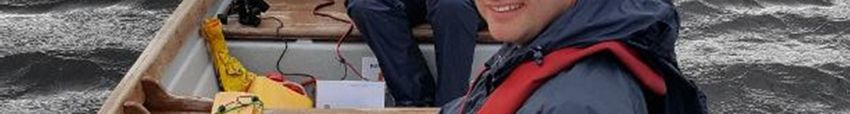
COPYRIGHT © 2017 LOUGHS AGENCY OF THE FOYLE CARLINGFORD AND IRISH LIGHTS COMMISSION

Headquarters
22, Victoria Road
Derry~Londonderry
BT47 2AB
Northern Ireland

Tel: +44(0)28 71 342100

Fax: +44(0)28 71 342720

general@loughs-agency.org

www.loughs-agency.org

Regional Office
Dundalk Street
Carlingford
Co Louth
Republic of Ireland

Tel+353(0)42 938 3888

Fax+353(0)42 938 3888

carlingford@loughs-agency.org

www.loughs-agency.org

Report Reference LA/Lake/03/17
CITATION: Niven, A.J. & Armstrong, F. (2017) Stillwater Status Report: Lough
Fad East, Co. Donegal. Loughs Agency, 22, Victoria Road, Derry~Londonderry

                                                                      Page 2 of 28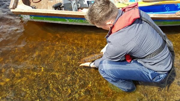
COPYRIGHT © 2017 LOUGHS AGENCY OF THE FOYLE CARLINGFORD AND IRISH LIGHTS COMMISSION

                              DOCUMENT CONTROL

 Name of Document             Stillwater Status Report: Lough Fad East

 Author (s):                  Art Niven & Fearghail Armstrong

 Authorised Officer:          John McCartney

 Description of Content:      Stillwater Fish Stock Assessment

 Approved by:                 John McCartney

 Date of Approval:            December 2017

 Assigned review period:      5 Years

 Date of next review:         August 2022

 Document Code                LA/LAKE/03/17

                                                                                No.
                              TOC    Text List of tables Table of Figures
                                                                             Appendices
 This documents comprises
                                X       X        X                X

                              Version Control Table

 Version No.         Status    Author (s)     Reviewed by    Approved by    Date of issue

                Draft         Art Niven &     John           John           December
 Version 1                    Fearghail       McCartney      McCartney      2017
                              Armstrong

 Version 2

 Version 3

                                                                           Page 3 of 28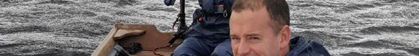
COPYRIGHT © 2017 LOUGHS AGENCY OF THE FOYLE CARLINGFORD AND IRISH LIGHTS COMMISSION

TABLE OF CONTENTS

TABLE OF CONTENTS ......................................................................................... 4
ACKNOWLEDGEMENTS ...................................................................................... 6
PROJECT STAFF 2017.......................................................................................... 6
EXECUTIVE SUMMARY ....................................................................................... 7
1.0     INTRODUCTION ........................................................................................ 8
       Fig 1. Stillwater Fish Survey being carried out on Lough Fad (East), 2017. . 8
2.0 BATHYMETRY SURVEY .................................................................................. 9
       Fig 2. Survey preparations. ......................................................................... 9
       Fig 3 Bathymetry map and locations of survey nets deployed on Lough Fad
       East. ......................................................................................................... 10
3.0 METHODS .................................................................................................. 11
       Table 1. Details of survey nets deployed on Lough Fad East..................... 11
       Fig 4. Nets being prepared before being deployed on Lough Fad East. .... 11
       Fig 5 ......................................................................................................... 13
       Figure 6 The precise location of each net was recorded using a handheld
       Trimble Geo HT GPS ................................................................................. 14
4.0 RESULTS ..................................................................................................... 15
   4.1 SPECIES RICHNESS .................................................................................. 15
       Table 2. Number of each species captured by each gear type during the
       survey of Lough Fad East, 2017. ............................................................... 15
   4.2 FISH ABUNDANCE................................................................................... 15
       Table 3. Mean (± S.E.) CPUE and BPUE for all fish species recorded on Lough
       Fad East, 2017. ......................................................................................... 16
       Fig 7. Sample of Brown Trout (Salmo trutta) top 2 images and Arctic charr
       bottom image from Lough Fad East, 2017................................................ 16
       Fig 8. Mean (± S.E.) CPUE for all fish species captured in Lough Fad East,
       2017. ........................................................................................................ 17
                                                                                                      Page 4 of 28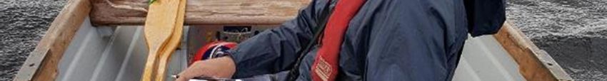
COPYRIGHT © 2017 LOUGHS AGENCY OF THE FOYLE CARLINGFORD AND IRISH LIGHTS COMMISSION

       Fig 9. Mean (± S.E.) BPUE for all fish species captured in Lough Fad East,
       2017. ........................................................................................................ 17
   4.3 BROWN TROUT STOCK DENSITY & POPULATION STRUCTURE ................ 18
       Fig 10. Mean CPUE for all Brown Trout .................................................... 18
       Fig 11. Mean BPUE for all Brown Trout .................................................... 19
       Fig 12. Length frequency Brown Trout, Lough Fad East 2017 (N=8) ......... 19
       Fig 13. Length weight relationship of Brown Trout, Lough Fad (East) 2017
       (n=8) ........................................................................................................ 20
       Fig 14. Sampling ....................................................................................... 20
   4.4 ARCTIC CHARR STOCK DENSITY & POPULATION STRUCTURE ................. 21
       Fig 15. ...................................................................................................... 21
   Fig 16. Mean BPUE Arctic Charr ................................................................... 22
   Fig 17. Length frequency of Arctic Charr, Lough Fad (East) 2017 (n=2) ........ 22
   4.5 FISH AGE AND GROWTH ......................................................................... 23
       Fig 18. Comparison growth curve showing back calculated length........... 23
5.0 DISCUSSION ............................................................................................... 24
       Fig 19 & 20 dredged channel and spoil at Lough Fad East august 2017 .... 24
6.0 INVASIVE SPECIES ....................................................................................... 26
7.0 BIOSECURITY .............................................................................................. 27
8.0 RECOMMENDATIONS ................................................................................. 27
9.0 REFERENCES ............................................................................................... 28

This document and its contents are copyright of the Loughs Agency ©2017

                                                                                                     Page 5 of 28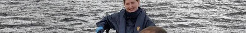
COPYRIGHT © 2017 LOUGHS AGENCY OF THE FOYLE CARLINGFORD AND IRISH LIGHTS COMMISSION

ACKNOWLEDGEMENTS

The Loughs Agency sponsoring departments, board and staff are gratefully
acknowledged for the funding, support and assistance provided to conduct
stillwater fish stock assessments and status reporting in the Foyle and
Carlingford areas. Donegal County Council and Irish Water are also gratefully
acknowledged for their co-operation.

PROJECT STAFF 2017

Fisheries Biologist/Project Manager           Art Niven
Fisheries Intern                              Fearghail Armstrong
Assistant Scientific Officer                  Jayne Holmes
Assistant Scientific Officer                  Paul Doherty
GIS Manager                                   Rachel Scott
Fisheries Intern                              Roseanne Shelley

For further information contact art.niven@loughs-agency.org

@ArtNiven           Loughs Agency TV

© LOUGHS AGENCY OF THE FOYLE CARLINGFORD AND IRISH LIGHTS COMMISSION 2017

                                                                      Page 6 of 28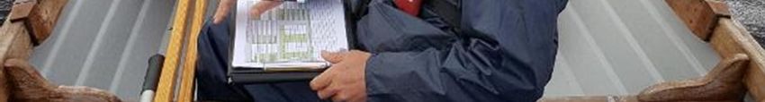
COPYRIGHT © 2017 LOUGHS AGENCY OF THE FOYLE CARLINGFORD AND IRISH LIGHTS COMMISSION

EXECUTIVE SUMMARY

A Water Framework Directive compliant stillwater fish stock assessment was
carried out on Lough Fad East in August 2017. The Loughs Agency commenced
a small rolling programme of lake fish surveys in 2010 to gain a better
understanding of fish species composition and abundance of the standing
waterbodies within the Foyle and Carlingford areas. The information collected
can be used for many purposes ranging from formal Water Framework Directive
classification, a baseline survey for use in the scrutiny of any future development
proposals and for contributing towards the sustainable development of the
angling amenity.

Lough Fad East is situated approximately 5km north of Redcastle, Co. Donegal.
The lough is nestled in a picturesque area and is utilised by Irish Water/Donegal
County Council as a public water supply for Quigleys Point, Moville, Redcastle
and Greencastle. A previous depth survey had been conducted and accurate
depth (bathymetry) data was available to direct the fish survey.

The 2017 fish stock assessment noted the presence of two fish species in Lough
Fad, Brown trout and Arctic charr. Impacts upon the lough noted at the time of
survey included significant water abstraction resulting in extremely low water
levels and habitat damage from dredging and spoil disposal. Both impacts could
be having a significant impact on the population of the vulnerable Artic charr.

This lake survey report provides a baseline of species presence and their relative
abundance to resource managers and anglers. It is anticipated that this survey
report could contribute towards the future management and sustainable
development of the angling amenity, conservation of the nationally vulnerable
Arctic charr population and wider development of the lough by providing the
basis for an evidence based approach to the management of the lough.

If access to the Fish in Lakes 2 Water Framework Directive classification tool was
available a WFD compliant classification could also be derived for Lough Fad East
and provided to the Environmental Protection Agency for national reporting
purposes.

                                                                      Page 7 of 28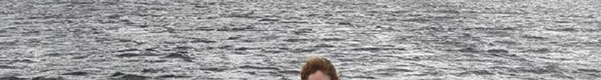
COPYRIGHT © 2017 LOUGHS AGENCY OF THE FOYLE CARLINGFORD AND IRISH LIGHTS COMMISSION

1.0 INTRODUCTION

Lough Fad East is located approximately 5km North of Redcastle, in the Foyle
catchment. The lake is approximately 40 metres above sea level and its principal
dimensions are;

   · Length: (718)m long, maximum width (259.2) metres
   · Surface area: (13.8) hectares
   · Maximum depth: 15 metres

Fig 1. Stillwater Fish Survey being carried out on Lough Fad (East), 2017.

                                                                             Page 8 of 28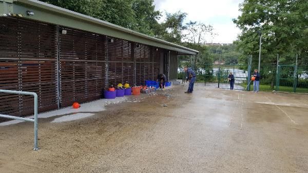
COPYRIGHT © 2017 LOUGHS AGENCY OF THE FOYLE CARLINGFORD AND IRISH LIGHTS COMMISSION

2.0 BATHYMETRY SURVEY

It is a prerequisite of any WFD compliant lake fish survey to have detailed
bathymetry data. This enables the survey to be carried out in accordance with
the standard sampling methods for the assessment of ecological status in
freshwater lakes across the island of Ireland (Eco-region 17). The area of the lake
(ha) and the maximum depth (m) are used to determine the distribution and
number of gill nets required for the survey. A bathymetry survey for Lough Fad
East had previously been completed by AFBI prior to the lake fish survey. This
data was obtained from AFBI and used by the Loughs Agency for this survey.

Fig 2. Survey preparations.

                                                                      Page 9 of 28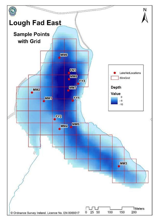
COPYRIGHT © 2017 LOUGHS AGENCY OF THE FOYLE CARLINGFORD AND IRISH LIGHTS COMMISSION

Fig 3 Bathymetry map of Lough Fad East, Co Donegal
COPYRIGHT © 2017 LOUGHS AGENCY OF THE FOYLE CARLINGFORD AND IRISH LIGHTS COMMISSION

3.0 METHODS

Lough Fad East was surveyed over one night from the 2nd of August 2017
according to the methodology described in the Water Framework Directive
compliant NS Share Methods Manual for systematic surveying of lakes for fish
(NSSHARE, 2008). A total of 12 nets were set as summarised in Figure 3 below.

 Net type                      No. Deployed                   Water depth (m)

 Dutch fyke nets                             3                         0 – 2.9
 (chain of 3)
 Multi-mesh gill nets                        2                         0 – 2.9

 Multi-mesh gill nets                        2                         3 – 5.9

 Multi-mesh gill nets                        2                        6 – 11.9

 Multi-mesh gill nets                        2                        12 – 19.9

 Floating gill net                           1                        12 – 19.9

Table 1. Details of survey nets deployed on Lough Fad East.

Fig 4. Nets being prepared before being deployed on Lough Fad East.
                                                                          Page 11 of 28
COPYRIGHT © 2017 LOUGHS AGENCY OF THE FOYLE CARLINGFORD AND IRISH LIGHTS COMMISSION
Survey locations were chosen within randomly selected 50m X 50m grid squares
overlaid on a bathymetric map of the lough (Figure 5.). The location and depth
of each net is also shown. A handheld Trimble Geo HT GPS was used to record
the precise location of each net as shown in (Figure 6). Any fish which were alive
and in good condition were measured and released live after removal from the
nets. All other fish were removed from the nets and identified and measured at
Loughs Agency headquarters.
Page 12 of 28COPYRIGHT © 2017 LOUGHS AGENCY OF THE FOYLE CARLINGFORD AND IRISH LIGHTS COMMISSION
Fig 5 Lough Fad East bathymetry map overlaid on 50m grid squares.
Page 13 of 28COPYRIGHT © 2017 LOUGHS AGENCY OF THE FOYLE CARLINGFORD AND IRISH LIGHTS COMMISSION
Fig 6. Net locations
Page 14 of 28COPYRIGHT © 2017 LOUGHS AGENCY OF THE FOYLE CARLINGFORD AND IRISH LIGHTS COMMISSION
4.0 RESULTS
4.1 SPECIES RICHNESS
Two fish species were recorded during the fish survey of Lough Fad East in
August 2017 with a total of 10 fish captured during the survey. A list of species
captured by each gear type is presented in Table 2. Brown trout (Salmo trutta)
were the most common fish species encountered in the benthic gill nets. The
floating gill nets captured equal numbers of both fish species encountered.
Common Scientific Benthic Fyke Floating Total
Name Name Gill Nets Gill Nets
Nets
Brown Salmo trutta 7 0 1 8
trout
Arctic Char Salvelinus 1 0 1 2
alpinus
Table 2. Number of each species captured by each gear type during the survey of Lough Fad
East, 2017.
4.2 FISH ABUNDANCE
Fish abundance, mean catch per unit effort (CPUE) was calculated as the mean
number of fish caught per metre of net. Fish biomass, mean biomass per unit
effort (BPUE) was calculated as the mean weight of fish caught per metre of net.
For all fish species CPUE/BPUE is based on all nets including fyke nets. Weights
were not available from those fish which were released alive. In such cases
weights were calculated from the length weight relationship of recorded fish. A
summary of CPUE and BPUE data for each species is shown in Figure 8 and 9
below.
Page 15 of 28COPYRIGHT © 2017 LOUGHS AGENCY OF THE FOYLE CARLINGFORD AND IRISH LIGHTS COMMISSION
Brown trout were the dominant fish species in terms of abundance and also in
terms of biomass. Arctic Charr were much lower in terms of abundance and also
in terms of biomass as shown below in Table 3.
Common name Scientific name 2017 CPUE 2017 BPUE
Brown Trout Salmo trutta 0.021 (0.011) 6.54 (3.96)
Arctic Charr Salvelinus alpinus 0.005 (0.0032) 0.17 (0.12)
Table 3. Mean (± S.E.) CPUE and BPUE for all fish species recorded on Lough Fad East, 2017.
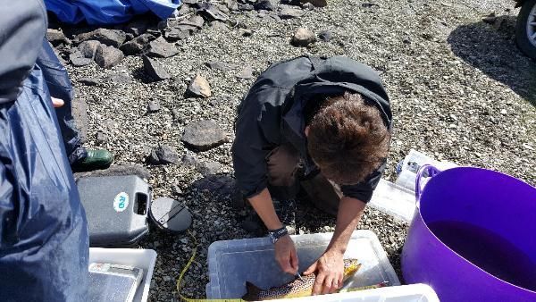
Fig 7. Sample of Brown Trout (Salmo trutta) top 2 images and Arctic charr bottom image
from Lough Fad East, 2017.
Page 16 of 28COPYRIGHT © 2017 LOUGHS AGENCY OF THE FOYLE CARLINGFORD AND IRISH LIGHTS COMMISSION
0.035
0.03
CPUE (number of fish/m of net
0.025
0.02
0.015
0.01
0.005
0
Brown Trout Arctic Charr
Species
Fig 8. Mean (± S.E.) CPUE for all fish species captured in Lough Fad East, 2017.
12
10
BPUE (number of fish/m of net
8
6
4
2
0
Brown Trout Arctic Charr
Species
Fig 9. Mean (± S.E.) BPUE for all fish species captured in Lough Fad East, 2017.
Page 17 of 28COPYRIGHT © 2017 LOUGHS AGENCY OF THE FOYLE CARLINGFORD AND IRISH LIGHTS COMMISSION
4.3 BROWN TROUT STOCK DENSITY & POPULATION STRUCTURE
The relative density (CPUE & BPUE) and length frequency distribution of Brown
trout is presented below in Figures 10, 11 and 12. Values are also compared with
other lakes which have been surveyed within the Foyle and Carlingford areas. A
total of 8 Brown trout were recorded during the Lough Fad East survey, lengths
ranged from 170mm to 450mm (mean length 277mm). The abundance of Brown
Trout from Lough Fad East is significantly lower than other surveyed loughs. 44
Brown trout were recorded from Lough Muck (Donegal) in 2012, lengths ranged
from 69mm to 212mm (mean length 168mm). 18 Brown trout were recorded
from Lough Alaan in 2013, lengths ranged from 134mm to 314mm (mean length
234mm). 3 Brown trout were recorded from Lough Carn in 2010, lengths ranged
from 389mm to 422mm (mean length 406mm). 25 Brown trout were recorded
from Lough Ash 2011, lengths ranged from 297mm to 421mm (mean length
343mm). 2 Brown trout were recorded from Lough Mourne 2010, lengths
ranged from 205mm to 220mm (mean length 213mm). 59 Brown trout were
recorded from Lough Nambradden 2014, lengths ranged from 55mm to 240mm
(mean length 147mm). 48 Brown trout were recorded from Lough Trusk in 2016,
lengths ranged from 135mm to 325mm (mean length 225mm).
0.25
0.2
CPUE (Number of fish/m net)
0.15
0.1
0.05
0
Mourne Carn 2010 Ash 2011 Muck 2012 Alaan 2013 Nambraddan Trusk 2016 Fad 2017
2010 (Donegal) 2014
Site
Fig 10. Mean CPUE for all Brown Trout captured in Lough Mourne 2010, Carn 2010, Ash
2011, Lough Muck (Donegal) 2012, Alaan 2013 Nambraddan 2014, Trusk 2016 and Lough
Fad East 2017.
Page 18 of 28COPYRIGHT © 2017 LOUGHS AGENCY OF THE FOYLE CARLINGFORD AND IRISH LIGHTS COMMISSION
50
45
BPUE (Mean biomass (g) of fish/m net)
40
35
30
25
20
15
10
5
0
Mourne 2010 Carn 2010 Ash 2011 Muck 2012 Alaan 2013 Nambraddan Trusk 2016 Fad 2017
(Donegal) 2014
Site
Fig 11. Mean BPUE for all Brown Trout captured in Lough Mourne 2010, Carn 2010, Lough
Muck (Donegal) 2012, Nambraddan 2014, Alaan 2013, Ash 2011, Trusk 2016 and Lough Fad
East 2017.
3
2
Frequency
1
0
140 - 149
100 - 109
120 - 129
160 - 169
180 - 189
200 - 209
220 - 229
240 - 249
260 - 269
280 - 289
300 - 309
320-329
340-349
360-369
380-389
400-409
420-429
440-449
20 - 29
40 - 49
60 - 69
80 - 89
0-9
Length (mm)
Fig 12. Length frequency Brown Trout, Lough Fad East 2017 (N=8)
Page 19 of 28COPYRIGHT © 2017 LOUGHS AGENCY OF THE FOYLE CARLINGFORD AND IRISH LIGHTS COMMISSION
1200
y = 3E-05x2.8341
1000 R² = 0.9913
800
Weight (mm)
600
400
200
0
0 50 100 150 200 250 300 350 400 450 500
Length (mm)
Fig 13. Length weight relationship of Brown Trout, Lough Fad (East) 2017 (n=8)
Fig 14. Sampling
Page 20 of 28COPYRIGHT © 2017 LOUGHS AGENCY OF THE FOYLE CARLINGFORD AND IRISH LIGHTS COMMISSION
4.4 ARCTIC CHARR STOCK DENSITY & POPULATION STRUCTURE
The relative density (CPUE & BPUE) and length frequency distribution of Arctic
charr are presented below in Figures 15, 16 & 17. A total of 2 Arctic Charr were
recorded in Lough Fad East, lengths ranged from 153mm to 158mm (mean
length 156mm). Arctic Charr are only known to be present in two loughs within
the Loughs Agency jurisdiction. The other known population is in Lough Finn, Co
Donegal. A WFD compliant fish survey was also conducted on Lough Finn in
2017.
The abundance of Arctic charr from Lough Fad East is lower than Lough Finn. 27
Arctic charr were recorded from Lough Finn in 2017, lengths ranged from 60mm
to 214mm (mean length 175mm).
0.035
0.030
0.025
CPUE (Number of fish/m net)
0.020
0.015
0.010
0.005
0.000
Lough Fad 2017 Lough Finn 2017
Fig 15. Mean CPUE Arctic Charr, Lough Fad (East) 2017 and Lough Finn 2017
Page 21 of 28COPYRIGHT © 2017 LOUGHS AGENCY OF THE FOYLE CARLINGFORD AND IRISH LIGHTS COMMISSION
2.000
1.800
1.600
Bpue (Mean biomass (g) of fish/m net
1.400
1.200
1.000
0.800
0.600
0.400
0.200
0.000
Lough Fad 2017 Lough Finn 2017
Fig 16. Mean BPUE Arctic Charr, Lough Fad (East) 2017 and Lough Finn 2017
2.5
2
1.5
Frequency
1
0.5
0
130 - 139
140 - 149
110 -119
150 -159
100 - 109
120 - 129
160-169
170-179
10 - 19
20 - 29
30 - 39
40 - 49
50 - 59
60 - 69
70 - 79
80 - 89
90 - 99
0-9
Length (mm)
Fig 17. Length frequency of Arctic Charr, Lough Fad (East) 2017 (n=2)
Page 22 of 28COPYRIGHT © 2017 LOUGHS AGENCY OF THE FOYLE CARLINGFORD AND IRISH LIGHTS COMMISSION
4.5 FISH AGE AND GROWTH
Scales were taken from all 8 Brown trout and both Arctic charr caught during
this survey for fish aging and back calculated growth analysis. Figure 18 below
outlines the average length at age for Brown trout caught during the Lough Fad
East survey and compares them to Brown Trout caught in Lough Muck (2012),
Lough Nambraddan (2014) and Lough Trusk (2016). A range of age classes were
present in Lough Fad East with the oldest Trout found to be in the 6+ age class.
Lough Muck Lough Nambraddan
50 Lough Trusk Lough Fad (East)
45
40
35
30
Length (cm)
25
20
15
10
5
0
L1
L2
L3
L4
L5
L6
Length at age
Fig 18. Comparison growth curve showing back calculated length at age for Brown Trout,
Lough Muck (2012), Lough Nambraddan (2014), Lough Trusk (2016) and Lough Fad East
(2017).
Page 23 of 28COPYRIGHT © 2017 LOUGHS AGENCY OF THE FOYLE CARLINGFORD AND IRISH LIGHTS COMMISSION
5.0 DISCUSSION
Lough Fad East lies within Magheradrumman Bog SAC. It is also a source of
public water supply for the east Inishowen area. Continued abstraction at this
site is having a negative impact upon the remaining population of Arctic charr.
Previous surveys recorded greater numbers of Arctic charr than were
encountered during the 2017 survey. It should also be noted that water levels
were at the lowest level observed at the site by the authors. Due to the
pressures for water the channel area leading to the weir which impounds Lough
Fad has been dredged to maintain abstraction in extremely low water
conditions. The dredge spoil had been spread in the adjacent area Figures 19 &
20.
Fig 19 & 20 dredged channel and spoil at Lough Fad East august 2017
Page 24 of 28COPYRIGHT © 2017 LOUGHS AGENCY OF THE FOYLE CARLINGFORD AND IRISH LIGHTS COMMISSION
As outlined in previous reports by the Irish Charr Conservation Group the
population of Arctic charr in Lough Fad East are littoral (shoreline) spawners and
are extremely susceptible to water abstraction. Charr require their spawning
habitats to be covered in water during their eggs incubation period which
probably extends from early November to early May. During this time ova and
alevin will be vulnerable to water drawdown. It is also essential that the water
level should not be allowed to drop below the level at which spawning
commences from November to the following May.
The Arctic charr population in Lough Fad East is one of only two populations
within the Loughs Agency jurisdiction. If consideration is not given to managing
water levels appropriately it is highly likely that this population of Arctic charr
will become extirpated/locally extinct in the near future.
Lough Fad East also holds a population of Brown trout. It is of note that no Brown
trout under 13 centimetres were encountered during the 2017 survey which
may indicate little or no recruitment to the population in recent years. There is
currently no connection between the outflow and the lake due to the presence
of a weir, any spawning potential would be limited to the littoral area. It is also
possible that Brown trout have been introduced as an angling resource as larger
fish. Any unauthorised stocking should be discouraged and it should be noted
that it is an offence under the Foyle Fisheries Acts to introduce any fish to a
watercourse without prior consent by the Loughs Agency, failure to comply
could result in prosecution. In addition any introduced Brown trout may also
predate upon the Arctic charr.
This report is a baseline survey of fish stocks in Lough Fad and it is hoped that it
can provide the basis for an evidence based approach to the management of the
lough. Fishery managers and anglers should also have an opportunity to review
the report and consider its recommendations when developing any future
angling initiatives for Lough Fad.
The information presented in this report can also be used to compare stocks
from any other water body where the same survey method has been used.
Page 25 of 28COPYRIGHT © 2017 LOUGHS AGENCY OF THE FOYLE CARLINGFORD AND IRISH LIGHTS COMMISSION
6.0 INVASIVE SPECIES
Invasive non-native species are those which have been transported outside of
their natural range. They are capable of spreading rapidly and colonising a wide
range of habitats. They also exhibit competitive dominance by out-competing
native flora and fauna for light, oxygen and food. There is growing evidence to
suggest that invasive riparian plants are having an adverse effect on aquatic
habitats and species by altering both in-stream processes and terrestrial-aquatic
linkages. Invasive species threaten native species as direct predators or
competitors, as vectors of disease, and by modifying the native habitats.
Invasive species are considered the second biggest threat after habitat loss to
biodiversity worldwide by the Millennium Ecosystem Assessment in 2005.
Water is an excellent transport medium for the dispersion of many of these
species. Rivers and loughs with their banks and shorelines are amongst the most
vulnerable areas to their introduction, spread and impact. The focus for the
Loughs Agency is predominantly on aquatic and riparian invasive species as
these are a serious threat to our sensitive aquatic habitats. The spread of
invasive species can also further threaten already endangered native species. In
freshwater habitats the introduction of invasive species is considered the
second leading cause of species extinctions. Invasive species are a global
problem and once they are established eradication is often costly and extremely
difficult. Previous studies suggest that early intervention is a more successful
and cost-effective way of preventing the spread of invasive species.
There are a multitude of invasive non-native species across the UK and Ireland
at present, many of them with the potential to cause serious environmental
harm. Three species in particular, Japanese Knotweed (Fallopia japonica),
Himalayan Balsam (Impatiens grandulifera) and Giant Hogweed (Heracleum
mantegazzianum) have become an established threat to the streams and rivers
of the Foyle and Carlingford areas. Rivers are an excellent means of transporting,
dispersing and spreading invasive species, therefore it is no great surprise to see
a proliferation along our river corridors.
There is a growing body of evidence demonstrating the damaging impacts of
(INNS) invasive non-native species. The problem of excessive soil erosion along
Page 26 of 28COPYRIGHT © 2017 LOUGHS AGENCY OF THE FOYLE CARLINGFORD AND IRISH LIGHTS COMMISSION
the riparian zone can have grave consequences for freshwater fish species.
Atlantic salmon (Salmo salar) and Trout (Salmo trutta) are reliant upon finding
appropriately sized spawning gravel to complete their life cycle. However,
Himalayan Balsam will die back in winter time, leaving behind exposed river
banks devoid of any natural vegetation. The lack of vegetation on the riparian
zone leaves the bank highly susceptible to soil erosion at times of increases flows
and floods. Excessive soil erosion will increase the sediment load into the stream
reach and can potentially smother the eggs buried in the spawning gravel,
starving them of oxygen. Atlantic salmon stocks are at unprecedented low levels
and they are also experiencing very high mortality rates during the marine phase
of their life cycle. Increased sediment being introduced to rivers and streams has
the potential to diminish juvenile abundance even further and merely
exacerbates the problem still further.
7.0 BIOSECURITY
Invasive species are an ever present threat in our aquatic and riparian systems
and it is imperative that none of our field operations exacerbate the risks to the
environment and to the economy that are posed by these species. Fish parasites,
pathogens and diseases also represent a significant threat to the health status
of our watercourses. The introduction or transfer of such pathogens or diseases
has the potential to wipe out large populations of fish in affected waters or
catchments. Loughs Agency staff are required to be vigilant to help prevent the
spread of fish diseases and invasive species. The agency has incorporated
biosecurity protocols into its freshwater fisheries monitoring programme and
these guidelines are also adhered to by fishery officers and field staff alike. The
Loughs Agency biosecurity protocol for field operations was fully implemented
during the Lough Fad fish survey.
8.0 RECOMMENDATIONS
· Communicate the findings of the survey to Irish Water and Donegal
County Coucil with the aim of highlighting the impacts of water
abstraction upon littoral spawning Arctic charr.
· Repeat survey every 5 years.
Page 27 of 28COPYRIGHT © 2017 LOUGHS AGENCY OF THE FOYLE CARLINGFORD AND IRISH LIGHTS COMMISSION
· Compare results against any future surveys in the Foyle area to ascertain
comparative growth rates across and within a range of stillwaters of the
Foyle and Carlingford areas.
· Communicate findings internally to colleagues and externally to
stakeholders
· Continue to conduct stillwater fish surveys temporally and spatially within
the Foyle and Carlingford areas.
· Promote Biosecurity awareness with angling community
9.0 REFERENCES
Igoe, F (2007) Identification of and characterisation of the spawning area used
by Arctic char in Lough Fad East (Moville) and estimation of vulnerable period of
ova and post hatch fry to water draw down. Irish char Conservation Group.
Dublin.
Kelly, FL (2008) WFD Surveillance Monitoring Fish in Lakes (2007) Central and
Regional Fisheries Board report.
Kelly, F.L., Connor, L., Wightman, G., Matson, R., Morrissey, E O’Callaghan, R.,
Feeney, R., Hanna, G. and Rocks, K., (2009) Sampling fish for the Water
Framework Directive – Summary Report 2008. Central and Regional Fisheries
Board report.
North South Share Aquatic Resource (NS Share). Methods Manual V Fish (2008)
European CEN Standard. Water quality-Sampling of fish with multi-mesh gill
nets (2005).
Page 28 of 28You can also read