Stroll of Discovery Riverfront Trail - Belleville, Ontario
←
→
Page content transcription
If your browser does not render page correctly, please read the page content below
Stroll of
   Discovery
Riverfront Trail
Belleville, Ontario
2
Bellevilleʼs Historic Riverfront
Archaeological remains show us that the river flowing
through the City of Belleville has been a focus of human
activity since the last Ice Age. To the Anishinaabe
people, it was the Sagonaska, while Europeans have
called it Singletonʼs Creek, Meyersʼ Creek and the
Moira.
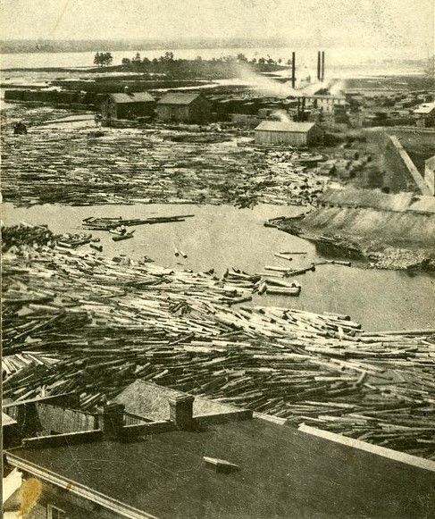
The river has been a focus for industry, for powering
the grist and lumber mills, and as a mode of
transportation for the vast quantities of timber felled in
its watershed in the 1800s. Its fish and its waters have
supported human life, while its ice and floods have
threatened it.
This short guide highlights the history of this stretch of
river and the buildings that surround it.
It was produced by the Hastings County Historical
Society and the Community Archives of Belleville and
Hastings County.
Find this tour on your
smartphone with the
PocketSights app.
Research by John Lowry
Contemporary photographs by Gerry Fraiberg
Historic photos from the collections of the
Community Archives of Belleville and Hastings County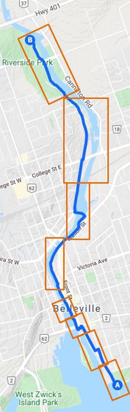
3

Route overview and
key to page numbers

   Distance: from A to B 5 km
   Time: around 1 hour
   Accessibility: Suitable for
   wheelchairs, cycles, and
   strollers
   Parking: available at
   Meyersʼ Pier A and
   Riverside Park B

          Share your photos
                 with
          #RiverfrontStroll

         #RiverfrontStroll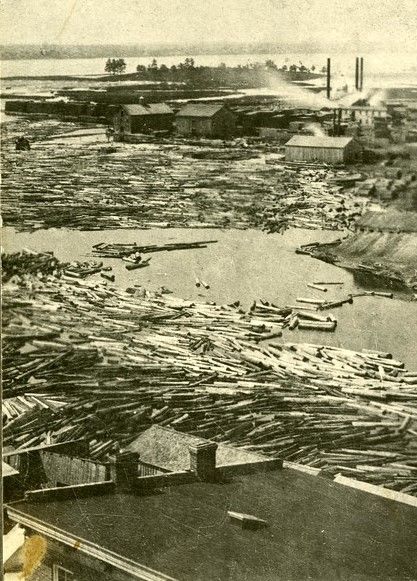
4
                         1. Meyersʼ Pier

                         Originally the government wharf and
                         warehouse and Bellevilleʼs port of entry. In
                         1983 the City assumed ownership and by
                         2007 had transformed the area into the
                         recreational focal point of a newly
                         revitalized waterfront.

2. The Norris Whitney Bridge

This single arch bridge was built in
1980-1982 and was named for
Norris Whitney MPP, who was
instrumental in its construction. The
first bridge to span the Bay of Quinte
was completed in 1891 and included
a swing bridge section.

                         3. The Thurlow Purchase

                         In 1816 the Mississauga First Nation
                         surrendered a 428-acre parcel of land. The
                         area had originally been set aside as a
                         native burial ground in 1783.
                         Compensation was agreed upon in 2010
                         with the Alderville First Nation in relation to
                         this purchase.
4. Jane Forrester Park

Jane Forrester was Bellevilleʼs first woman
Mayor (1956-1957). This park symbolizes
the reclamation of industrial sites along the
waterfront, a cause that Jane Forrester had
championed in the 1980s. The park was
dedicated to her in November, 2001.
                         5. 16 South Front Street

                         Now the Royal Canadian Sea Cadet building,
                         this property was formerly the home of the
                         South End Athletic Club, founded in 1933
                         as an offshoot of the Wharf Street Debating
                         Club to encourage interest in sports in
                         Belleville.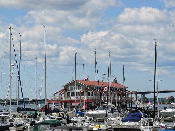
5
                        6. Sir Mackenzie Bowell Monument

                        Mackenzie Bowell (1823-1917) arrived in
                        Belleville as a youth in 1832. He started out
                        as an apprentice at The Intelligencer
                        newspaper and went on to own the firm. He
                        entered federal politics in 1867 and served
                        as Prime Minister of Canada from 1894 to
                        1896.

7. Wharf Street Debating Club Plaque

This plaque marks the location of a
converted wooden boathouse that once
hosted colourful “bun feeds” for City
Council candidates. After nearly a century,
the club moved to the Foster Ward Hall and
the old building was demolished.

                        8. 45-47 South Front Street (McIntosh-
                        Ridley House)

                        This property was built in 1817 and is one
                        of the few early harbour settlement
                        buildings standing. It was owned by Martha
                        McIntosh, daughter of a United Empire
                        Loyalist and later by Dr. George Ridley. It
                        received a heritage designation in 1983.

9. Turn left for a detour to Victoria Park

A public park since the late 1800s, this
former island was the site of the Rathbun
Company sawmill until 1876, when the city
took it over. The Bay of Quinte Yacht Club is
located on the southern tip of the park.

                        10. Belleville Plaque in Victoria Park

                        This Ontario Heritage Trust plaque outlines
                        a brief history of Belleville from its
                        foundation around 1790 as a milling and
                        shipping centre, to its growth as a railway
                        town and its incorporation as a city in 1877.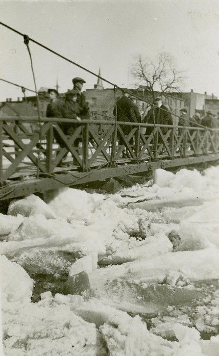
6

                       11. Parrott Riverfront Trail

                       This scenic trail runs for 1.6 km (1 mile)
                       along the east and west banks of the
                       Moira River, through the historic
                       downtown section of the City of Belleville.
                       It was named after local philanthropists
                       John and Bernice Parrott in 2005.

12. Wilbur C. Purcell Bridge
The Dundas Street bridge was built in
1970 to carry Highway 2 across the
Moira River. It was dedicated to honour
Wilbur C. Purcell (1925-2000), the
former City Engineer and City Manager
for Belleville, in October, 2003.

                       13. United Empire Loyalist Monument
                       This monument was designed by
                       J. Arnold Thompson and built by George
                       A. Bennett in 1924 to commemorate the
                       140th anniversary of the landing of UEL
                       settlers in 1784. It was moved across
                       the street in 2004 and rededicated in
                       2005.

14. Simpsonʼs Tavern plaque
Margaret Simpson operated a tavern in
this area from 1797 until 1825, an early
community hub for the settlement of
Meyersʼ Creek. She built a frame inn in
1820, which stood on the northeast
corner of the intersection until it was
demolished in 1978.

                       15. Moira River
                       The Moira is one of the largest river
                       systems in Hastings County. It flows
                       from Tudor Township for 98 km (61
                       miles) into the Bay of Quinte with a
                       watershed of over 713,000 acres. Its
                       former names included the Sagonaska,
                       Singletonʼs Creek and Meyersʼ Creek. It
                       was named after the Earl of Moira in
                       1807.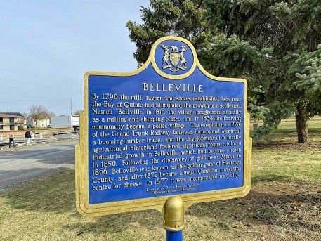
7

                        16. 160 Front Street
                        Only the facade of the three-storey
                        Bogart-Carman building remains. It was
                        built by John Forin in 1872-1873 and
                        housed The Daily Ontario and later The
                        Intelligencer newspaper for many years. It
                        collapsed during renovation work in
                        1990.

17. 169 Front Street (City Hall)
Built in 1872-1873, the imposing City
Hall is an example of High Victorian
architecture. It was designed by John
Evans and built by John Forin. In 1987-
1988 the interior was substantially
renovated to accommodate two
additional floors.

                        18. Billa Flint House (across river)
                        The house at 180 Coleman Street was
                        built in 1835 for prominent Bellevillian
                        Billa Flint (1805-1894). He was a
                        prosperous lumberman and merchant
                        who served as Mayor of Belleville,
                        Warden of Hastings, and in the Provincial
                        Legislature. He was appointed a senator
                        in 1867.

19. Quinte Consolidated Courthouse
(across river)
The courthouse was opened in 2013 and
brought the Superior and Ontario Courts
under one roof, which previously
operated in four court locations (three in
Belleville and one in Trenton).The
structure houses 11 courtrooms.

                        20. Belleville Bridge
                        This is the site of the first bridge across
                        the Moira River, built in 1806-1807. The
                        twin concrete double-spanned bowstring
                        arches on this and the Moira Bridge were
                        built in 1930 as an employment relief
                        project during the Great Depression.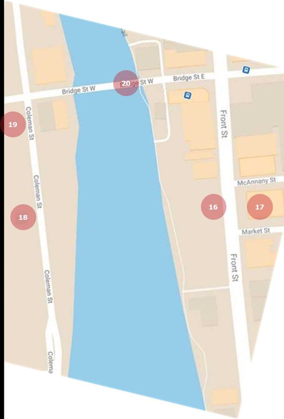
8
21. J. B. (Ben) Corke Footbridge
There has been a pedestrian bridge at
this location since the 1870s. The
original steel suspension bridge was
damaged by floods and replaced by a
concrete structure in the 1940s. It was
named for former Mayor Ben Corke in
2003.
22. 257 Coleman Street
This three-storey building with
decorative brick crenellations was
constructed for the Deacon Shirt
Company after a fire destroyed their
original building on this site in 1911. It
housed an optical company from 1924
to 1948 and has been the home of
Lanning Headwear since 1949.
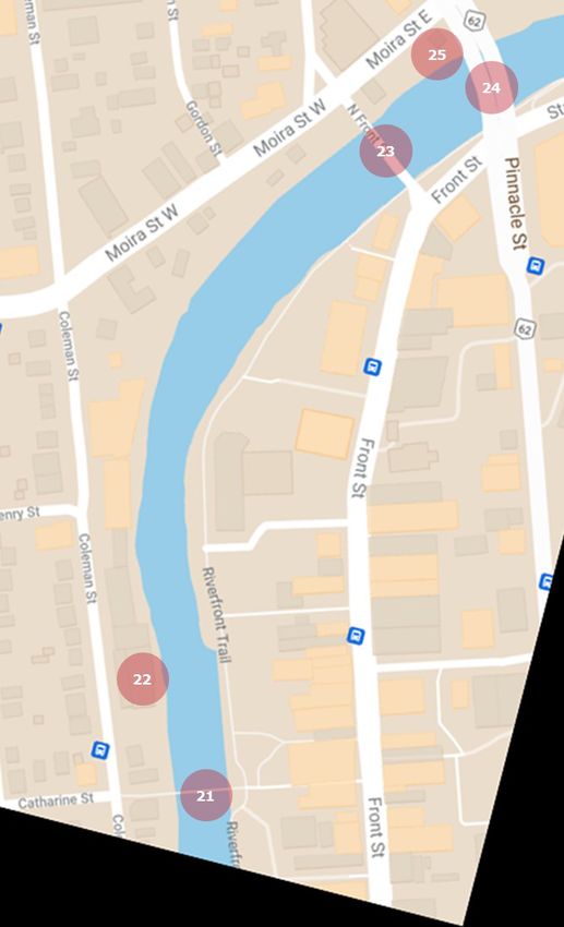
23. Moira Bridge
The second concrete double-span
bowstring bridge to cross the Moira was,
like the Belleville Bridge, constructed in
1930 as part of a federal government
work relief program to provide
employment during the Great
Depression.
24. Sagonaska Bridge
This six-lane, two-span concrete
structure opened in 1978 to connect
Pinnacle Street to the west bank of the
Moira River. The name comes from the
original Anishinaabe name for the river.
25. Cross bridge for 5 Moira St. East
The Belleville Chamber of Commerce has
its headquarters in the rustic log cabin in
the Sagonaska Parkette. The cabin was
brought to Belleville from Haleyʼs Station
in the Ottawa Valley in 1978. It also
serves as a tourist information centre.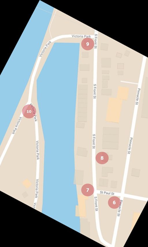
9

                       26. 54 Station Street
                       This area was purchased by John Walden
                       Meyers for a grist mill in 1789. This
                       limestone structure was built in 1879 by
                       Ellis Burrell, who operated an axe factory
                       on the site. It was rescued from
                       demolition in 1978 by the Hastings
                       County Historical Society.

27. Captain John Walden Meyers Plaque
This Ontario Heritage Trust plaque
commemorates John Walden Meyers
(1745-1821), an early United Empire
Loyalist settler in Belleville. His mills
formed the nucleus of the pioneer
community of Meyers Creek, which was
renamed Belleville in 1816.

                       28. Lions Park
                       This park was established with support
                       from the Lions Club of Belleville, which
                       received its charter in 1958. It features a
                       Lions Club Friendship Arch, symbolizing
                       friendship between neighbouring
                       nations.

29. Lott Dam
The Lott Dam was rebuilt in 1978-1979
as part of the Moira River Conservation
Authority flood control strategy. Above
the dam is the Kay Manderville
Pedestrian Bridge, dedicated to the
former city councillor in October 2020.

                       30. Turn right for detour to Memorial
                       Park
                       Memorial Park at 130 Station Street has
                       been home to Bellevilleʼs cenotaph since
                       1932. The original structure was removed
                       in 2001 and the park was redesigned and
                       reconfigured to include the Thurlow War
                       Memorial. Thurlow Township became part
                       of the City of Belleville in 1998.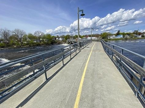
10
                        31. Canadian National Railway Bridge
                        There has been a bridge at this location
                        since 1856 when the Grand Trunk
                        Railway arrived in Belleville. The town
                        became a major railway centre and by
                        1903 the bridge had been widened to
                        hold a second line.

32. College Street Bridge
This concrete bridge was constructed in
1966 and replaced an earlier steel truss
bridge. College Street was named for
Albert College, which used to be on the
north side of the street until it burned
down in 1917 and moved to Dundas
Street West.

                       33. Riverside Park West
                       This park comprises land originally
                       acquired by the Moira River Conservation
                       Authority on the west bank of the river
                       in 1975. It hosts a number of
                       playground complexes and serves as a
                       recreational focal point for the city.

34. J. H. McLeod Dam
This dam was completed in 1979 and
was the second of two ice-control dams
built by the Moira River Conservation
Authority to reduce the chances of
springtime flooding in Belleville. Named
for James H. McLeod, the dam produces
hydroelectricity.

                       35. Lazierʼs Dam ruins
                       Lazierʼs Dam was formerly used to
                       power the Lazier Paper Mill, which
                       ceased operations in the 1920s. Since
                       the time of Meyersʼ mills, six or more
                       dams have been used to provide power
                       to various industries in Belleville.
11
36. Belleville Kiwanis Skate Park
This park opened in the fall of 2008 and
provides local youth with a purpose-built
skateboarding and BMX biking facility for
multiple age groups. The Kiwanis Club of
Belleville donated $100,000 towards the
project.
37. Belleville Yardmen Dam
This ice control dam was dedicated in
1987. The dam was named in
recognition of the role that the Belleville
Yardmen Benefit Fund played in helping
build the Quinte Sports Centre. The
Yardmen were employees of the
Canadian National Railway.
38. Quinte Sports & Wellness Centre
There has been a sports facility on this
site since 1978 when the Yardmen Arena
was built. In 2012 the complex was
expanded with a swimming pool,
additional ice pads, fitness studios and a
walking track. In 2017 the centre
became home to Belleville Senators of
the American Hockey League.
39. Rick Meagher Rotary Play Park
This park includes the Lady Nicole Pirate
Ship and West Riverside Splash Pad. Rick
Meagher is a former professional hockey
player who founded a charity golf
tournament to support the needs of
physically challenged children and their
families in the Quinte region.
40. Harry Mulhall Dam
This dam was dedicated to long-time
Intelligencer reporter Henry A. J. Mulhall,
better known as Harry, in October 1989.
Harry started with The Intell in 1962 and
eventually became city editor for the
newspaper. He passed away in 1987 at
the age of 53.12
This birdʼs-eye view of Belleville was drawn by Herman Brosius
(1851-1917) and printed by Charles Sober & Co. Of Chicago in
1874. Brosius accurately depicted all the buildings existing in the
town at the time.
For more information on the history of Belleville and its river, visit:
Hastings County Historical Society - hastingshistory.ca
Hastings Historical Plaques - hastingshistoricalplaques.ca
Community Archives of Belleville and Hastings County - cabhc.ca
July, 2021You can also read