Resource Management 2021 - US Department of the Interior
←
→
Page content transcription
If your browser does not render page correctly, please read the page content below
Katmai National Park and Preserve National Park Service
Aniakchak National Monument and Preserve U.S. Department of the Interior
Alagnak Wild River
Resource Management 2021
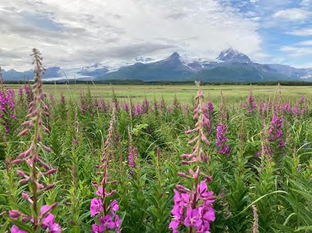
Fireweed blooms at Hallo Bay in Katmai National Park. NPS K. Griffin
National Park staff working in Katmai National Park and Preserve, Aniakchak National
Research Permits
Monument and Preserve, and the Alagnak Wild River spend time in the field to study,
In addition to work conducted by NPS
inventory, and monitor cultural and natural resources. staff, external researchers come to the
The cultural resource program involves archeology and anthropology and focuses on the parklands to conduct a wide array of
history of human occupation in the region. The natural resource program studies biological studies. The diversity of work helps to
and physical resources, such as wildlife, fish, plants, wilderness, and backcountry resources. answer local management questions as
well as those of greater interest to
The COVID-19 pandemic has affected our ability to complete scheduled field work in 2020 science. The parks are a vibrant, living
and may continue to impact research efforts in 2021. laboratory.
Look for project and research updates on our website (www.nps.gov/katm), Facebook page,
and through the explore.org Katmai bear cams.
Wilderness Visitor Study: Understanding Visitors' Desired Social and Natural
Conditions- Project Update
Researchers from Clemson and Kansas State Universities sought to provide insight into the backcountry and wilderness experiences
of visitors to Katmai National Park and Preserve (KATM). This was a two-phase project, with research taking place during both the
2018 and 2019 summer seasons, aiming to provide an enhanced level of detail regarding the characteristics that compose KATM-
based visitor experiences and the immersive opportunities that are provided through this dynamic landscape. As a result of the
increasing popularity of KATM’s natural resources and unique visitor experiences, visitation has continued to rise. Park managers
are tasked with understanding the impacts of such visitation and developing optimal, effective management strategies as they
continuously strive to maintain a balance between visitor needs and the environment. To aid in this endeavor, university
researchers employed a two-phase process, with the assistance of park managers, to investigate visitor’s perceptions of their
experiences.
Resource Management News: Volume 11
Wilderness Visitor Study cont.
The data collected from this research not only provides
foundational details in comprehending the ideal visitor
experience but offers integral information for management
decisions as well, through the gained understanding of visitor
viewpoints and actions.
Both phases of this research used a quantitative questionnaire to
evaluate the preferences of visitors concerning their
backcountry and wilderness experiences in KATM. For the 2018
summer season, questionnaires asked about any important
aspects of the visitor experience. These results guided questions
asked during the 2019 summer season regarding the
experienced and expected quality of such experiential aspects. Utilization distribution for all summer visits in 2017 containing a
Based on the expansive backcountry and wilderness contexts green (lowest degree of visitor use) to red scale (highest degree
within KATM, researchers spent time in varying locations to of visitor use).
contact visitors and gain a representative reflection of the
ongoing visitation experiences and resulting visitor perceptions.
Six indicators, or aspects important to experience quality, were
chosen to represent a visit to KATM. These included the
individual distance to a focal bear, the amount of anthropogenic
sound heard per hour, the number of other groups within view,
the number of other groups encountered per day, the number of
fish caught per day with previous scarring, and the number of
bears viewed per hour. While preferences and experienced
conditions varied across user groups and locations visited, the
majority of visitors reported conditions at or exceeding their
expectations. Researchers conducted additional analyses to help
understand use and preferences at KATM. One such analysis
involved the development of utilization distributions, a 3-
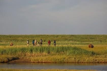
dimensional map of the intensity of visitor use across the park. Visitors at Hallo Bay engaging in the varied and available
The final report is in the review process. wildlife-based opportunities within Katmai National Park and
Preserve.
Katmai’s vast road-less wilderness and often inclement weather makes accessing areas of
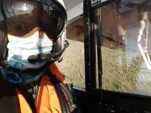
Wildlife Aerial Surveys the park difficult for biologists trying to monitor wildlife populations. Aerial surveys
provide a way to access this landscape and study some of Katmai’s keystone species.
Bears, bald eagles, and moose are all surveyed at locations and times when their
concentrations are known to be high. Surveys are flown in small 2 seat aircraft at low
levels off the ground. Both pilot and observer work together to spot and record the
number of a wildlife species gathered at a location.
The pandemic of 2020 created challenges for the continued monitoring of Katmai’s
keystone species. Maintaining the health and safety of staff and the community was a top
priority. Through additional planning by staff and the support of community available
Covid-19 testing, much of the aerial survey data were still collected this year.
Covid mitigation plans enabled
observers to continue some of our Bald eagles are surveyed during the spring to better understand nest occupancy and
aerial surveys like on salmon stream reproductive success. Bald eagles are important indicators of freshwater and marine
surveys for bears pictured below. ecosystems because their survival and productivity are dependent on high quality
freshwater and marine food sources. Due to the pandemic, bald eagle surveys were not
conducted during 2020. Katmai plans to resume bald eagle surveys in 2021 using newly
developed Covid-19 mitigation protocols.
Counts of bears and cubs during the summer allow the park to monitor the bear
population and look for factors that might be affecting it. The sedge meadow and stream
surveys not only help to understand salmon run timing and abundance, but also indicate
bear numbers and productivity. In 2020, sedge meadow surveys were conducted with
pilot and no observer.
2 Resource Management News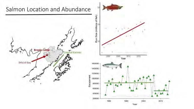
Although changing to a single observer can affect the number of bears seen, the use of
Wildlife Surveys cont.                  satellite phones allowed the pilot to call in observations to biologists who could record the
data. Counts of bears congregating on salmon spawning streams and sedge meadows were somewhat higher than previous years
which could indicate abundant food resources and potentially a growing population.
Moose counts of bulls, cows, and calves are conducted during the winter to monitor the moose population and look for
environmental factors that might be affecting the population. During 2020, moose surveys were completed with both pilot and
observer. Surveys were completed in the Branch River and Angle/Takayofo trend areas. An average of 67 bulls:100 cows and 25
calves:100 cows were seen which is close to the 5-year average for these trend areas.
In 2021, Katmai plans to incorporate a caribou survey along the northern border of Katmai Preserve. The survey will be supported
through Subsistence Advisory Council funds and help Resource Advisory Councils and the park better understand and manage
caribou in Game Unit 9.

Willow Ptarmigan Pilot Study
In spring 2021 we will begin a 2-year willow ptarmigan study in Katmai National
Park and Preserve and Aniakchak National Monument and Preserve. The project
will be supported through Subsistence Advisory Council funds and help Resource
Advisory Councils and park management of ptarmigan populations in Game Unit
9. Ptarmigan are an important subsistence species on the Alaska Peninsula;
however, there is limited data on how their population and density has changed
over time. Ptarmigan numbers are known to be cyclical in many areas in the Arctic
and their numbers can fluctuate greatly between years. Our pilot study will establish
transect surveys that will allow us to determine a baseline density estimate of
ptarmigan in these areas and add to existing knowledge from ptarmigan data               Ptarmigan in Aniakchak National Preserve
collected in Becharof National Wildlife Refuge.                                          Photo: C. Ricks

                                                                 In 2020, we continued our non-invasive pilot project to study
Katmai coastal wolf project                                      Katmai’s enigmatic coastal wolf population. In conjunction with
                                                                 other survey efforts we collected scat from coastal and interior areas
                                                                 of the park and tested hair sampling techniques near Fures cabin.
                                                                 We will continue and expand upon these sampling efforts through
                                                                 2023, with a focus on investigating the unique foraging ecology of
                                                                 wolves on the Katmai coast. We will significantly increase the
                                                                 number and coverage of trail cameras along the shoreline and up
                                                                 coastal streams where wolves are suspected of fishing the salmon
                                                                 run. For this summer, our intention is to extensively search several
                                                                 coastal regions for the scats of wolves and other cryptic carnivores.
                                                                 The scat and hair samples we collect will be analyzed at Oregon
                                                                 State University to characterize the role of wolves as generalist
                                         Prey remains            carnivores in Katmai's nearshore community. In the laboratory, we
                                         from wolf scat          will employ both DNA metabarcoding of prey in wolf scats and
                                         are processed           stable isotope analysis of hair and tissue samples to reconstruct the
                                         in a lab. A             short- and long-term diets of individual wolves. The metabarcoding
                                         process called
                                         metabarcoding           process involves extracting and amplifying specific regions of
                                         extracts                genomic DNA, then sequencing these segments with a machine that
                                         regions of DNA          can differentiate DNA molecules. The result of this analysis is a
                                         researchers             reconstruction of every prey species that a wolf has consumed over
                                         can sequence
                                         to identify prey        the past few days. Complementarily, stable isotope analysis will
                                         consumed.               provide us with a more general overview of the contribution of
                                                                 marine vs. terrestrial prey items to a wolf’s diet over the course of
                                                                 many months. We will obtain genotypes (individual wolf identities)
                                                                 from these samples using single-nucleotide polymorphisms (SNPs),
                                                                 which represent genetic variation within a species through collective
                                                                 single-unit differences in DNA strands. These multiple data streams
                                                                 from the laboratory and field will help us piece together the complex
                                                                 and fascinating puzzle of coastal wolf ecology in Katmai.

                                                                                                          Resource Management News 3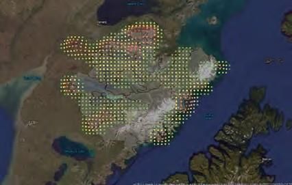
Changing Tides Project
 The Changing Tides project in Katmai was designed to investigate the link between nearshore and terrestrial ecosystems, specifically
 coastal brown bears and intertidal invertebrates. The project’s graduate student, Joy Erlenbach, defended her PhD in 2020 from data
 collected in Katmai 2015-2017.The study investigated in part, to what degree female bears along the coast consume non-salmon
 marine resources like clams, flounder, sea otter, and seals. Study findings indicated these resources did not show up in substantial
 portions in bears’ dietary estimates. Erlenbach also found that the proportion of salmon in coastal female bear diets and the number
 of observable bears at Hallo Bay have decreased by around 50% over the last 17-27 years (Figure 1). Erlenbach stressed the potential
 importance of considering how bears in similar areas (such as within Katmai National Park) might be experiencing different
 nutritional stresses depending on the status of the salmon species or stocks that are available to them (such as bears on the coast
 with the primary species [pink and chum salmon] exhibiting low abundance versus bears on the interior with the primary species
 available [sockeye salmon] exhibiting record high abundance; Figure 1).

 Figure 1. The carbon and nitrogen stable isotope values of bear hair, in relation to potential diet items (plant matter and salmon). Hair is
 grown approximately May-September and therefore represents approximately the annual diet. Annual diet estimates from the bear hair
 (1989 in red, 2015-2017 in teal), showing much lower salmon consumption during this study (2015-2017), and trends in salmon abundance
 (pinks and chums) for coastal bears during the 1989 study and during our study (green), versus sockeye salmon abundance for interior
 (Brooks camp and other) bears (red).

 Further work needs to be done to determine whether the large decrease in salmon consumption seen during the Changing Tides
 study was a transient response to low salmon abundance during the study or a signature of a more long-term trend. Regardless, the
 finding seems to indicate that bears’ diets can significantly change in what appears to be a response to low salmon abundance.
 Another finding in Erlenbach’s study showed that as salmon consumption decreased over the last 27 years, plant matter
 consumption increased, with densities of bears on salt marshes in Katmai being 43 times higher than the average density of bears in
 the park, and often exceeding the densities of bears found at the mouths of coastal salmon streams. The high densities of bears on
 salt marshes may be an indicator of resource quality. The combination of protein in sedges and high digestible carbohydrate in
 goose tongue vegetation in salt marshes can lead to high caloric intake when the two are consumed together. All bears gained weight
 early in the season consuming primarily vegetation, suggesting that plant resources can be important for bears to meet their
 nutritional needs. Plant matter resources may act as an important buffer resource if other food items (including salmon) decline.
 Finally, Erlenbach’s research resulted in improvements to methods currently used to estimate diets of wild bears. Erlenbach’s
 dissertation titled "Nutritional and Landscape Ecology of Brown Bears (Ursus arctos)" can be found online through ProQuest (ID
 2453710130). Erlenbach continues to work on coastal bear research as the bear biologist for the Kodiak National Wildlife refuge just
  across the Shelikof strait from Katmai.
Bear Scanning: A Non-invasive Tool                                       In 2018, Alaska regional GIS specialist Joel Cusick devised a
                                                                         method of laser scanning to non-invasively measure the volume
A high-precision terrestrial lidar scanner was used to create a          of the portly participants of Fat Bear Week. He returned this
three-dimensional model of bears used to estimate volume. Bear           year, armed with knowledge gained and the patience to wait for
747 came in at the largest volume of all the competitors at an
estimated 22.6 cubic feet—a little larger than an extra-large-           a bear waiting for a fish. Terrestrial LiDAR Scanning is used
capacity chest freezer or the equivalent of 80 bowling balls!            almost exclusively in civil engineering fields to scan interiors of
                                                                         buildings, so putting it to the test on live animals is new. Right
                                                                         now, we can use this to determine the volume of a bear as well
                                                                         as length, height, and girth. As we learn more, this could open
                                                                         other potential applications, perhaps even to monitor the
                                                                         overall health of these, and other, animals in the wild. More
                                                                         information about Fat Bear Week can be found at https://
                                                                         explore.org/fat-bear-week
4 Resource Management News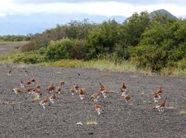
Katmai and Savonoski Village Remote Sensing and Archeological Survey
                                                                                           Laura Stelson (Penn State) proposes an
                                                                                           archeological survey employing remote sensing
                                                                                           methodology as part of her dissertation
                                                                                           fieldwork focused on cultural resiliency among
                                                                                           ancestral and historic Sugpiat-Alutiit villages of
                                                                                           the Katmai parkland interior and Pacific
                                                                                           coastline. Stelson is also partnering with the
                                                                                           Council of Katmai Descendants and the Native
                                                                                           Village of Perryville to provide Perryville School
                                                                                           students an immersive culture camp
                                                                                           opportunity and distance learning experience
                                                                                           using park archival materials and local oral
                                                                                           histories.
                                                                                           For more information, contact Linda Chisholm
                                                                                           (907-469-0322, or linda_chisholm@nps.gov).

Photo Credit: taken during National Geographic Society expedition to Katmai area 1918.
University of Alaska Anchorage. Consortium Library. Archives & Special Collections. 3211    Partnering with Elders Project, 2020 Update
Providence Dr. Anchorage, AK 99508, 1-907-786-1849.

West Naknek-American Creek Archeological                                                    Although the 2020 Cultural Resources field
                                                                                            season was canceled due to COVID-19, Park
Survey                                                                                      Archeologists Christina (Crissy) Phillips and
Sam Coffman (UAF-Museum of the North) is proposing to conduct an                            Laura Stelson continued to work on
archeological inventory of the West Naknek Lake and American Creek                          community and elders' projects with the
areas of Katmai National Park, to include Lake Coville, Lake Grosvenor,                     Native Village of Perryville and the Igiugig
Naknek Lake including the Iliuk Arm, and Lake Brooks. The study                             Village Council. The latter project helped
will provide NHPA section 110 inventory data for these areas of the park.                   produce a series of Elder's knowledge cards
The purpose is to identify archeological sites and features in the park                     based on Igiugig's recent Ethnobotany book,
interior, especially in regard to travel and trade across ancient glaciated                 designed by LaRece Construction.
landforms. The multi-year project employs a newly developed predictive                      For more information, contact Linda
site model and guidance from the Council of Katmai Descendants.                             Chisholm (907-469-0322, or
For more information, contact Linda Chisholm (907-469-0322, or
                                                                                            linda_chisholm@nps.gov).
linda_chisholm@nps.gov).

Other Natural Resources Program Updates
• Marine debris and seabird mortality
In collaboration with the National Oceanic and Atmospheric Administration (NOAA) and the Coastal Observation and Seabird
Survey Team (COASST) we completed marine debris surveys on beaches at Dakavak Bay and Hallo Bay. We surveyed for seabird
carcasses on our beaches at Hallo Bay and in our local community at Naknek Beach.
• Brooks River Bear Monitoring
Biologists continue to track individual bear use of Brooks River. The more than 20-year dataset is being used to estimate annual
survival of different age and sex groups within the local Brooks River bear population. Results from the study are expected in 2021.
• Backcountry Impacts Monitoring
Park staff continued the collection of field data, including photos and GPS locations, to document human impacts (evidence of
camping, campfires, etc.) in the backcountry. This is part of a long-term effort to monitor backcountry conditions. In 2020 field
work focused on the north arm of Naknek Lake.
• Bat Monitoring
The park continues to monitor bats in coastal and interior areas using acoustic monitors
• Invasive Plant Management
We treated invasive plants in the Brooks Camp Area and Fures Cabin and plan on having a larger crew to help with invasive plant
control in 2021.

                                                                                                               Resource Management News 5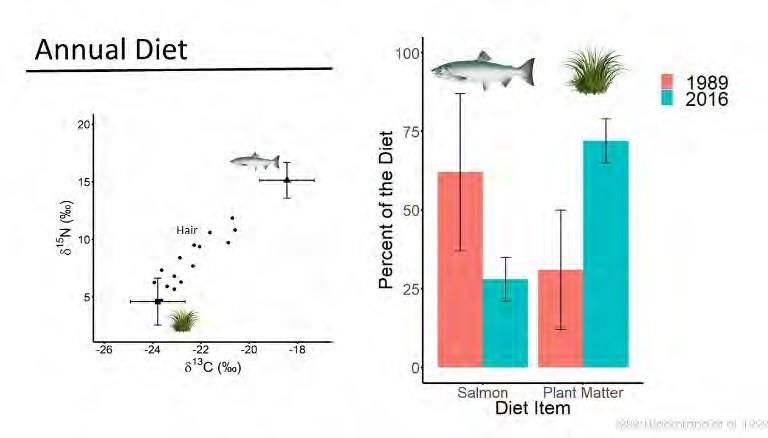
• Brown bear research report available online:
Spatio-temporal distribution of coastal brown bears and visitors in Katmai National Park, Alaska
https://irma.nps.gov/DataStore/Reference/Profile/2283864

Additional External Agency and Researcher
Projects
Water Quality Study of the Alagnak Wild River
Adventure Scientists - a not for profit group, intends to deploy volunteer scientists to
access the Alagnak and Nonvianuk Rivers by pack raft or kayak and will be using field
instruments to record dissolved oxygen, pH, temperature, and conductivity of the
waters. In addition, they will be collecting grab samples which will be laboratory
analyzed to detect dissolved nitrogen, nitrates, ammonium, phosphorus and
organophosphate, sodium, sulphates and metals. This data will be used to update the
water quality information for the Alagnak River and is being conducted in
conjunction with similar studies occurring across the National Wild and Scenic River
System.
Water Quality Study of the Aniakchak Wild River
Adventure Scientists - a not for profit group, intends to deploy volunteer scientists to
access the Aniakchak River by pack raft or kayak and will be using field instruments
to record dissolved oxygen, pH, temperature, and conductivity of the waters. In
addition, they will be collecting grab samples which will be laboratory analyzed to
detect dissolved nitrogen, nitrates, ammonium, phosphorus and organophosphate,             We will continue to collect timelapse
                                                                                           photography data at sedge and intertidal
sodium, sulphates and metals. This data will be used to update the water quality           areas to better understand bear and visitor
information for the Aniakchak River and is being conducted in conjunction with             activity patterns.
similar studies occurring across the National Wild and Scenic River System.
The Brown Bear Viewing Experience at Brooks River
                                                                                                        National Park Service
Michael Fitz from Explore.org is proposing to conduct a visitor use survey at Brooks                    U.S. Department of the Interior
Camp to determine the visitor experience at this location in the park as it relates to
their prior experiences with the Brooks Camp web camera system operated by
Explore.org. The team would be on site in the Brooks River area and would be                  This is the eleventh issue of Resource
intercepting visitors aged 18+ with a series of questions related to their previous           Management News produced by the
history with the web camera system and their experiences on the ground at Brooks              Division of Resource Management.
Camp.                                                                                         Katmai National Park & Preserve
                                                                                              Aniakchak National Monument &
Geophysical Imaging of the Magmatic Plumbing of the Katmai Volcanic Group                     Preserve
Paul Bedrosian with USGS and in collaboration with AVO would embark on a                      Alagnak Wild River
                                                                                              P.O. Box 7
multiyear project to measure the magma chamber located beneath the Katmai                     King Salmon, AK 99613
Volcanic Group. This project would entail the team setting up a series of
approximately 120 ground sensors that would take electromagnetic readings of the              Phone
                                                                                              (907) 246–3305
group beneath the sensors. The sensors would be buried into the ground to ensure
good contact with the measurable area and to reduce the amount of atmospheric                 Web
interference with the sensors. This study would be a first of it's kind for Katmai and        Katmai NP&P: www.nps.gov/katm
would further expand the scientific understanding of this volcanic area.                      Aniakchak NM&P: www.nps.gov/ania
                                                                                              Alagnak WR: www.nps.gov/alag
Geologic Investigation of Mt. Douglas and Fourpeaked Mountain Volcanoes
                                                                                              Contributors and Photo Credits:
Tim Orr with the USGS is proposing to conduct a project studying Fourpeaked                   Kelsey Griffin, Leslie Skora, Alyssa
Mountain and Mt. Douglas volcanoes located at the northeast corner of Katmai                  Reischauer, Linda Chisholm, Brian
                                                                                              Smith, Joy Erlenbach, Ellen Dymit,
National Park. The team will have several study areas around these volcanoes                  Kansas State University, Clemson
examining the exposed rock edifices to collect rock samples, a tephra study along the         University
adjacent riverbanks and gullies and all sides of the volcanoes, and a lahar and
pyroclastic flow study focusing on all major drainages near these mountains to                The National Park Service cares for
                                                                                              the special places saved by the
evaluate flowage deposits in terms of size, extent, and character. All laboratory             American people so that all may
analysis will be performed and administered by the USGS in Anchorage and                      experience our heritage.
collected samples will be temporarily curated and archived at the USGS Alaska
Tephra Laboratory and data center in Anchorage Alaska.

Resource Management News 6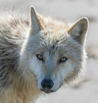
You can also read