EMERGING TWIN CITIES OF NOIDA AND GREATER NOIDA
←
→
Page content transcription
If your browser does not render page correctly, please read the page content below
Review Of ReseaRch
             impact factOR : 5.7631(Uif)        UGc appROved JOURnal nO. 48514               issn: 2249-894X

                                             vOlUme - 8 | issUe - 2 | nOvembeR - 2018
__________________________________________________________________________________________________________________________
EMERGING TWIN CITIES OF NOIDA AND GREATER NOIDA

Sudhir Kumar Sinha
Associate Professor, Department of Geography,
Shaheed Bhagat Singh (Eve.) College, University of Delhi, New Delhi.

ABSTRACT
         The urban population of Delhi has been increasing rapidly since 1950 which has caused
overcrowding, congestion, pollution and a number of other related problems. Therefore, the need to
decongest Delhi is being felt since long. National Capital Region Planning Board (NCRPB) was constituted to
achieve this objective. The present study analyses the urban development in Greater Noida which lies in
National capital region (NCR). Greater Noida emerged as a census town in 2011 and is developing fast. The
success of this town lies in the policy framework of NCRPB regional Plan – 2021, successful urbanization of
Noida by NOIDA Authority constituted by U.P. government in 1976, creation of job opportunities and good
infrastructure by GNIDA Authority, and location of Greater Noida in NCR and in the vicinity of Noida. The
successful urbanization in the neighborhood of NCT of Delhi has led to emergence of twin cities of Noida and
Greater Noida.

KEYWORDS: Urbanization, NCR, Overcrowding and Twin Cities.

INTRODUCTION:
         Since twentieth century urban population and level of urbanization in world as well as in India is
increasing rapidly. Today more than half of the world population is living in urban areas. In India, about one-
third of population is living in urban areas as urban population is witnessing continuous increase. The
maximum growth in the urban population in India in last few decades has taken place in large cities. The
urban population of Delhi has increased very rapidly since 1950 causing overcrowding and related problems.
Consequently, the need for decongestion of Delhi was felt and National Capital Region Planning Board was
formed to achieve this objective. The NCRPB has come up with a number of policy measures to decongest
Delhi mainly through development of National Capital Region (NCR) which would help in diverting Delhi
bound migrants to neighboring areas of NCR. These policy measures helped in urbanization in Noida - a city
sharing its western boundary with NCT of Delhi. Greater Noida lies adjacent to Noida with river Hindon
making the boundary between two cities. With rapid urbanization in Noida Uttar Pradesh government
sensed the opportunity to urbanize areas adjacent to Noida, and to control unplanned development in this
area, it created Greater Noida Industrial Development Authority (GNIDA) in 1991. Urbanization in Noida and
infrastructure development in Greater Noida provided impetus to urbanization in Greater Noida. The policy
measures of NCR Regional Plan – 2021, urbanization in Noida, and developmental work by GNIDA Authority
resulted into successful coming up of a new city (Greater Noida) adjacent to Noida city. Today, Noida and
Greater Noida have emerged as twin cities.
         The present paper aims to study the urban development in Greater Noida and consequent
emergence of twin cities of Noida and Greater Noida.

 ________________________________________________________________________________________
Available online at www.lbp.world
                                                                                        1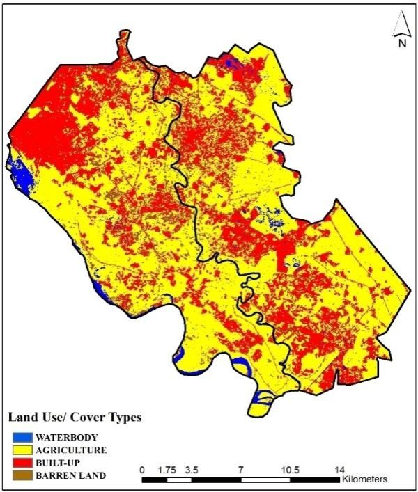
EMERGING TWIN CITIES OF NOIDA AND GREATER NOIDA                          vOlUme - 8 | issUe - 2 | nOvembeR - 2018
________________________________________________________________________________________
REVIEW OF LITERATURE
        A number of studies have been carried out to analyse the population growth of large cities and the
resultant problems (Roy, 1994; and NCRPB, 1989, 2005). These studies pointed out that there is need to
check migration in large cities by diverting in-migrants to neighbouring areas. For this, the strategy of
promoting satellite towns/ring towns/new towns was advocated. However, it was found that only self-
sustaining towns which could provide job opportunities have been successful. Other towns with poor
economic base and which could not create job opportunities have been stagnating and have not been
successful (Shaw, 2013). NCRPB (2005) has stressed the need for good infrastructure for success of new
towns.
        One of the earliest studies in geography on twin cities was carried out by Alam (1965). He has
described in detail the emergence of twin cities of Hyderabad and Secunderabad. The twin cities of Noida
and Greater Noida could evolve because of created job opportunities and good infrastructure.

The Study Area
        Greater Noida Industrial Development Authority (GNIDA) was constituted in 1991. GNIDA has a
notified area of 38,000 hectares comprising of 124 villages. However, in this study only 20,820 hectares of
land (Urban GNIDA) was included which had contiguous urban development as the rest of the area is
primarily rural. Three census towns- Greater Noida, Chipyana Buzurg and Chhapraula lie within this urban
zone of 20,820 hectares. However, Urban GNIDA more or less conforms to Greater Noida as only 794 ha of
land (out of 20,820 hectares) lies outside Greater Noida. Chipyana Buzurg and Chhapraula together cover
this remaining area of 794 hectares. Population of these towns is also small, i.e. 17,400 of Chipyana Buzurg
and 15,154 of Chhapraula as per 2011 census. Urban GNIDA has elongated shape having north-south
extension with river Hindon making the boundary between Noida and Greater Noida. It is located at the
inter-section of western and eastern dedicated freight corridors. It is also the gateway to the Delhi-Mumbai
Industrial Corridor (DMIC). Greater Noida lies adjacent to NOIDA and is a designated million city in NCR
Regional Plan-2021 which has assigned a population of 12 lakhs in 2021 to Greater Noida. It is coming up as a
modern planned city of highclass residence and industries.
        The planned development of Greater Noida started after the creation of Greater Noida Industrial
Development Authority in 1991. Consequently, the population of the area started increasing rapidly and
Census of India designated it as a census town in 2011 with a population of 1,02,054 persons comprising of
55,540 males and 46,514 females. The city has a sex ratio of 837 female per 1000 male; literacy rate of 73.91
per cent and work participations ratio of 36.63 per cent. However, there is wide variation in work
participation ratio in terms of sexas only 19.65 per cent females are working in comparison to 50.85 percent
male.

DATABASE AND METHODOLOGY
        The study is based upon secondary sources of information such as from Census of India, NCRPB, NCR
Planning Cell Uttar Pradesh, and other published sources. Land use/ cover change, spatial pattern of
urbanization and emergence of twin cities of Noida and Greater Noida has been examined by preparing
landuse/cover mapof the study area for four time periods (1977, 1991, 2001 and 2011). The maps were
prepared by downloading the Landsat imageries (path 146 and row 40) from the open source. For
preparation of land use/ cover maps unsupervised classification was carried out with the help of ERDAS
Imagine (2013 version) software (Sinha, 2017).

Urban Development in Greater Noida
       Urbanization in Greater Noida is a result of spatial interaction of developmental processes at regional,
sub-regional and local scale.

 ________________________________________________________________________________________
Available online at www.lbp.world
                                                                                        2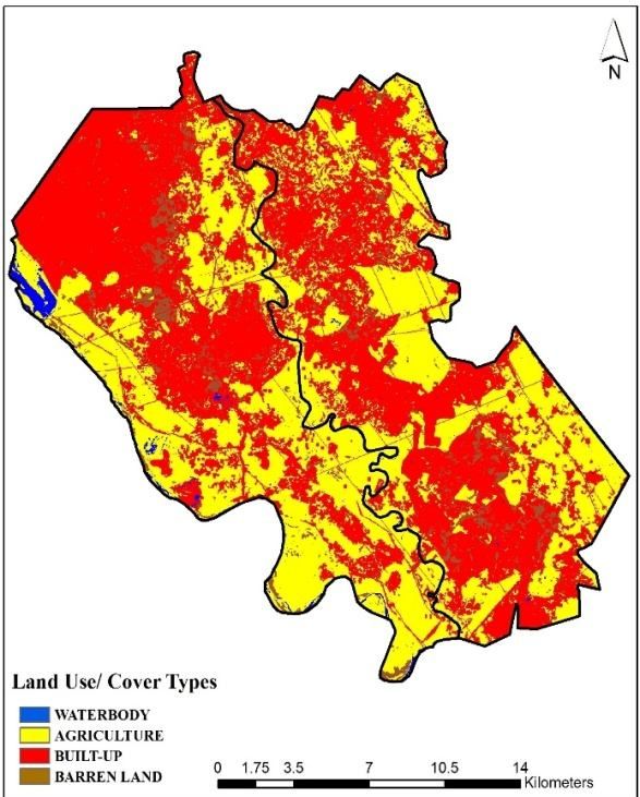
EMERGING TWIN CITIES OF NOIDA AND GREATER NOIDA                          vOlUme - 8 | issUe - 2 | nOvembeR - 2018
________________________________________________________________________________________
The Regional Scale
        The study area is a part of NCR. The city of Noida lies in the central National Capital region (CNCR
earlier called Delhi metropolitan Area – DMA) and Greater Noida lies in the Rest of NCR zone of NCR.
        National Capital Region: The unprecedented growth of NCT-Delhi has been a source of serious
concern to Government, planners, NGOs, Social Scientists as well as public at large. The city recorded an
extraordinary growth during 1941-1951 as lakhs of immigrants came to Delhi from Pakistan due to partition
of the country; the population of city practically doubled. Since then, the city is experiencing very high
growth rate of population; higher than any of the four largest mega cities of India.
        Keeping in view the unprecedented growth of population resulting into haphazard development of
city following the partition, the need for planned development of Delhi was felt. The first such exercise for
planned development was carried out by Town and Country Planning Organization (TCPO). It prepared an
Interim General Plan for Greater Delhi in 1956 and stressed the need for planning Delhi in a regional context.
The Master Plan for Delhi (MPD-1962) also advocated for planning of Delhi in the regional context. The
MPD-1962 for the perspective year 1981 delineated Delhi Metropolitan Area (DMA) covering an area of 800
square miles. It comprised of union territory of Delhi and adjacent six ring towns. The plan also defined the
National Capital Region and recommended the setting up of National Capital Planning Board. Consequently,
Government of India set up a High Power Board which entrusted TCPO to prepare a comprehensive regional
plan. Accordingly, TCPO prepared Regional plan-1981 of NCR in 1973. Thus, during all these years need was
felt to plan Delhi in the regional context under a suitable statutory body. There after Parliament enacted the
National Capital Region Planning Board Act in 1985 through which it constituted a statutory body named
National Capital Region Planning Board (NCRPB) for preparation, monitoring and implementation of plan for
the development of NCR. The NCRPB has prepared two perspective plans- the Regional Plan-2001 notified in
1989 and Regional Plan-2021 notified in2005.
        Aims and Objectives of NCR Planning: The Regional Plan-2001 laid down following developmental
policies aim in gat:
    i. Relieving the capital city from additionalpressures
   ii. Avoid adding new pressures on the capital.
  iii. Development of settlements in NCR to enable them to play their assigned role.

         The objectives of Regional Plan-2001 was to achieve a balanced and harmonious development of
region, leading to dispersal of economic activities and deflecting future in-migrants to Delhi, thereby leading
to a manageable Delhi. The Regional Plan-2021 while reviewing the Regional Plan-2001 observed that the
plan to contain population of Delhi and to deflect in-migrants to other NCR areas has met with very little
success. Thus, it advocated for vigorous development of NCR areas to contain the population of Delhi. For
this, Regional Plan-2021 proposed “to harness the spread of development impulse and agglomeration
economies generated by Delhi for harmonized, balanced and environmentally sustainable Socio-economic
development of the NCR with effective cooperation of the participating states” (NCRPB,2005). Accordingly,
Regional Plan-2021 aims to “promote growth and balanced development of the National Capital Region”.
Keeping in view the above objectives the Regional Plan-2021 proposed four policy zones:
i.    NCT Delhi: In this zone no new large economic activity either in secondary or tertiary sector which may
      generate large number of employments in formal or informal sector should be permitted. Only those
      activities be permitted which are necessary to sustain the local population ofDelhi
ii. Central National Capital Region(CNCR): The policy envisages that opportunities (economic
      opportunities, residential opportunities, educational and health facilities, comprehensive transport
      system, social infrastructure, quality of environment etc.) presented by CNCR need to be upgraded so
      that CNCR is able to effectively compete with NCT-Delhi. To provide a strong economic base to CNCR,
      the plan envisaged that the major economic and non-polluting activities should be located in planned
      urbanisable areas in this policy zone instead of getting located in the NCT Delhi policy zone. Noida city
      lies in this zone.
  ________________________________________________________________________________________
Available online at www.lbp.world
                                                                                                              3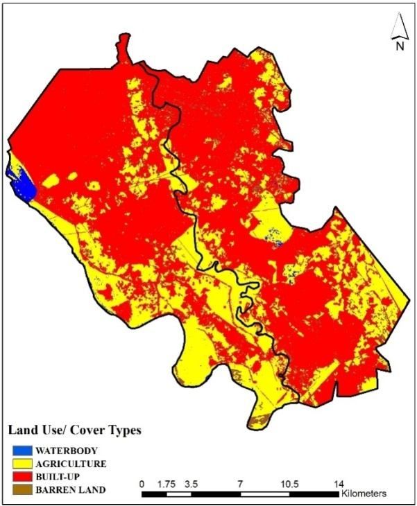
EMERGING TWIN CITIES OF NOIDA AND GREATER NOIDA                         vOlUme - 8 | issUe - 2 | nOvembeR - 2018
________________________________________________________________________________________
iii. Highway Corridor Zone(HCZ): This zone has been created to enable the planned and regulated
     development along designated highways. Activities in this zone will be controlled as per the zoning
     regulation of regional plan-2021. Excluding green buffer zones, respective state governments can
     permit land-use in this policy zone depending upon local situation, economic pressure and
     development potential of the area. While planning these zones, utmost care needs to be taken to
     ensure that the activities permitted here are segregated from high way traffic.
iv. Rest of NCR: Regional Plan-2021 envisages induced development of metro and priority towns in this
     zone. In order to achieve induced growth as well as encourage private investors to invest in this zone,
     the plan suggests upgrading of level of physical and social infrastructure in both urban and rural areas
     by the Centre and the concerned states. Greater Noida lies in this zone

The Sub-regional and Local Scale
        The root of urban development in Greater Noida lies in the creation of New Okhla Industrial
Development Area (NOIDA) in 1976 under the U. P. Industrial Area Development Act, 1976. The U. P.
Government observed the land speculation activity leading to unplanned and haphazard growth in the
vicinity of Delhi border in 1970’s. NOIDA was constituted to decentralize economic activities in Delhi in the
effort to prevent in-migration to Delhi; to stop speculative land dealings in the NOIDA area lying in close
proximity to Delhi; to check unplanned and haphazard growth; and to provide alternative sites doorstep to
Delhi for industrial and residential development at much lower price compared to Delhi. Altogether 81
villages covering an area of 20,316 ha of land was brought within NOIDA. NOIDA Authority (functioning
within the overall policy framework of NCRPB) through its successive plans was able to build a self-sustaining
city. It not only created good infrastructure but was also able to promote industrial, educational,
commercial, and institutional sectors besides offering affordable housing. All this led to a process of rapid
urbanization in NOIDA area.
        With the constitution of NOIDA the land activities got controlled in the area. However, the land
speculative activity shifted in the vicinity of eastern boundary of Noida i.e. Greater Noida. U. P. Government
sensed the opportunity in Greater Noida due to developmental impulse generated by Delhi, and
urbanization of NOIDA. It also wanted to curb the land speculative activity in Greater Noida. Thus, U. P.
Government constituted Greater Noida Industrial development Authority (GNIDA) in 1991 on the pattern of
NOIDA for planned development of this area and to prevent land speculative activities. Existence of rapidly
growing Noida City on its border; proximity to NCT Delhi, Faridabad and Ballabhgarh; its locationwith respect
to Yamuna Express Way, eastern and western dedicated freight corridor (DFC) and Delhi-Mumbai Industrial
Corridor (DMIC) – all this provided opportunity and strength to this region of faster economic development
and urbanization. With the constitution of GNIDA in 1991, the process of urbanization set in this area.
Consequently, Greater Noida which was totally rural in character at the time of constitution of GNIDA in
1991 emerged as a city in 2011.
        With the setting of urbanization process, the landuse/cover in Urban GNIDA started changing rapidly
(Table 1). The built-up area increased from 3131.06 ha in 1977 to 14,780.98 ha in 2011. The increase in the
built-up area between 1977 and 1991 was 281.25 ha annually (Table 2). This increase was mainly due to land
speculative activity taking place in the vicinity of NOIDA where land activity had got controlled due to
constitution of NOIDA in 1976. With the constitution of GNIDA in 1991 rapid planned urbanization started in
the study area resulting into faster landuse/cover change. The rate of change of built-up area annually
increased from 281.25 ha between 1977-1991 to 437.85 ha between 1991 and 2001. Altogether built-up
area increased by 11649.92 ha between 1977 and 2011. This urban development in vicinity of Noida city has
led to the emergence of twin cities of Noida and Greater Noida.

 ________________________________________________________________________________________
Available online at www.lbp.world
                                                                                        4
EMERGING TWIN CITIES OF NOIDA AND GREATER NOIDA vOlUme - 8 | issUe - 2 | nOvembeR - 2018
________________________________________________________________________________________
Table 1: Land Use/Cover-Urban GNIDA
In Hectares In percentage
Classes 1977 1991 2001 2011 1977 1991 2001 2011
Agriculture 16,221.60 12,745.13 8,489.65 5,579.13 77.91 61.21 40.77 26.80
Built Up 3,131.06 7,068.54 11,447.0814,780.98 15.04 33.95 54.98 70.99
Barren 978.27 670.14 812.12350.91 4.70 3.22 3.90 1.69
Land
Water 489.94 337.06 72.03 109.85 2.35 1.62 0.35 0.53
Total 20,820.87 20,820.87 20,820.8720,820.87 100 100 100 100
Table 2: Land Use/Cover Change-Urban GNIDA(per annum)
Year 1977-1991 1991-2001 2001-2011 1977-2011
Classes Hectare Percent Hectare Percent Hectar Percen Hectar Percen
e t e t
Agriculture -248.32 -1.53 -425.55 -3.34 -291.05 -3.43 -313.01 -1.93
Built Up 281.25 8.98 437.85 6.19 333.39 2.91 342.64 10.94
Barren -22.01 -2.25 14.20 2.12 -46.12 -5.68 -18.45 -1.89
Land
Water -10.92 -2.23 -26.50 -7.86 3.78 5.25 -11.18 -2.28
Twin cities evolve when two cities lying in close geographical proximity grow into each other over
time, losing most of their mutual buffer zone. To be a twin city generally the two cities have similar
administrative status and somewhat with comparable sizes. For example, a suburb lying close to a much
larger population center do not form twin city.
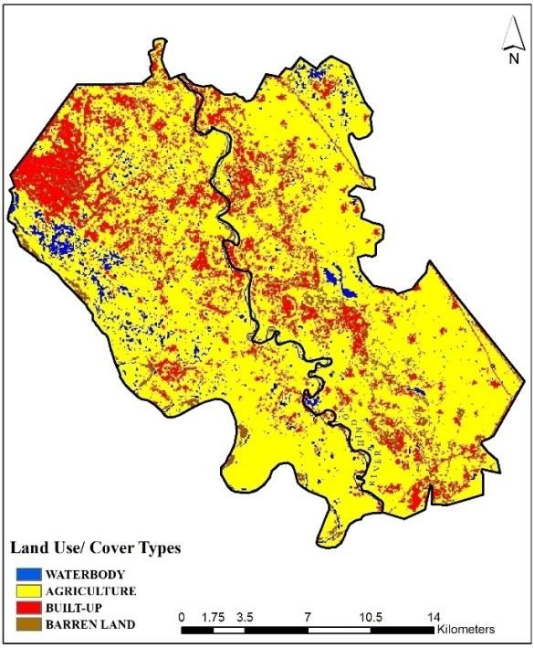
The landuse/cover map of study area (Fig 1a) shows that both Noida and Greater Noida were
primarily rural in character in 1977. Only prominent built-up area in the map lies in the north-western corner
of Noida. Greater Noida lacks urban development totally. The boundary between Noida and Greater Noida is
made by river Hindon. Noida lies in the west of river Hindon and Greater Noida to the east of it.
Landuse/cover map of 1991 (Fig 1b) shows significant change in the study area. Northern Noida emerges
prominently as the urbanized area. Some relatively larger patches of built-up area also emerge in Greater
Noida due to land speculation activities. Fig 1c reveals that rapid urbanization has taken place both in Noida
and Greater Noida between 1991 and 2011 as reflected in evolution of larger and denser patches of built-up
area. Fig 1d depicts that by 2011, both Noida and Greater Noida have emerged as a good example of twin
cities. Both the cities are new and have come up recently – Noida became a census town in 1991 and
Greater Noida in 2011. The size of both cities is comparable as both cities are designated metro centers in
regional Plan – 2021 of NCR. A comparative study of landuse/cover map of two cities (Fig 1a to 1d) reveal
that the two cities have grown over time into each other and there is hardly any buffer zone left between
the two cities. Thus by 2011, Noida and Greater Noida have evolved into twin cities.
________________________________________________________________________________________
Available online at www.lbp.world
5EMERGING TWIN CITIES OF NOIDA AND GREATER NOIDA vOlUme - 8 | issUe - 2 | nOvembeR - 2018
________________________________________________________________________________________
Fig 1(a) Fig 1(b)
Fig 1(c) Fig 1(d)
Fig 1: Landuse/Cover Map of Noida and Urban GNIDA(a) 1977, (b) 1991, (c) 2001, and (d) 2011.
CONCLUSION
The process of urbanization in the study area started with the constitution of NOIDA Authority in
1976. NOIDA Authority was successful in creating job opportunities and good infrastructure in Noida.
Viewing the development in Noida, UP government realized the potential of Greater Noida (lying east of
Noida) and thus constituted GNIDA Authority in 1991 for planned urban development of Greater Noida. The
policies of NOIDA and GNIDA Authorities resulted into the coming up of self-sustaining cities of Noida and
Greater Noida. The two cities have developed good infrastructure and economic base resulting into creation
of job opportunities. This has attracted population towards the two cities leading to urbanization and
emergence of Noida and Greater Noida as twin cities.
________________________________________________________________________________________
Available online at www.lbp.world
6EMERGING TWIN CITIES OF NOIDA AND GREATER NOIDA vOlUme - 8 | issUe - 2 | nOvembeR - 2018
________________________________________________________________________________________
REFERENCES
Alam, S. M. (1965). Hyderabad-Secunderabad (Twin Citeis): A Case Study in Urban Geography, Allied
Publishers Private limited, Bombay.
Census of India (2001). District Census Handbook, Gautam Buddha Nagar, series-10, part-XII-A & B, Uttar
Pradesh.
Census of India (2011). District Census Handbook, Gautam Buddha Nagar, series-10, part-XII-B.
National Capital Region Planning Board (1989). Regional plan 2001, National Capital Region, Ministry of
Urban Development, Govt. ofIndia.
National Capital Region Planning Board (2005). Regional plan 2021, National Capital Region, Ministry of
Urban Development, Govt. ofIndia.
Roy, B. K. (1994). Indian Urbanization: Proliferation of Mega Cities and Urban Corridors, in Dutt, A. K. et al.
(eds.) The Asian City: Process and Development, Characteristics and Planning, pp 145-158.
Shaw, A. (1995). Satellite Town Development in Asia: The Case of New Bombay, India, Urban Geography, Vol.
16, No. 3, pp 254-271.
Sinha, S. K. (2017). Urban Sprawl in Gautam Budh Nagar, Ph.D Thesis, Department of Geography, University
of Delhi. [Unpublished].
Sudhir Kumar Sinha
Associate Professor, Department of Geography, Shaheed Bhagat Singh (Eve.) College,
University of Delhi, New Delhi.
________________________________________________________________________________________
Available online at www.lbp.world
7You can also read