Relationship between Observed Seismicity and Water Level Fluctuations in Polyphyto Dam Area (North Greece)
←
→
Page content transcription
If your browser does not render page correctly, please read the page content below
Journal of Geography, Environment and Earth Science
                             International

                             21(2): 1-10, 2019; Article no.JGEESI.49100
                             ISSN: 2454-7352

           Relationship between Observed Seismicity and
          Water Level Fluctuations in Polyphyto Dam Area
                                           (North Greece)
                                                                                                   Kyriaki Pavlou1*
                       1
                        National and Kapodistrian University of Athens, Ilissia, Zografou, 157 84, Greece.

                                                                                                Author’s contribution

                            The sole author designed, analysed, interpreted and prepared the manuscript.

                                                                                                    Article Information

                                                                                    DOI: 10.9734/JGEESI/2019/v21i230122
                                                                                                                   Editor(s):
            (1) Dr. Suvendu Roy, Assistant Professor, Department of Geography, Kalipada Ghosh Tarai Mahavidyalaya, India.
                                                                                                                 Reviewers:
                                                                            (1) Orhan Polat, Dokuz Eylul University, Turkey.
                                        (2) Ali Amasha, Arab Academy for Science Technology & Maritime Transport, Egypt.
                                              Complete Peer review History: http://www.sdiarticle3.com/review-history/49100

                                                                                            Received 05 March 2019
  Original Research Article                                                                  Accepted 21 May 2019
                                                                                             Published 28 May 2019

ABSTRACT

 The spatial-temporal seismicity in Aliakmona river area is presented for the period 1974-2010 (NW
 Greece). This study area, which was classified as low seismicity, presents a particular interest due
 to the unexpected strong earthquake of Ms=6.6 which occurred between the cities of Kozani–
 Grevena, at a distance of 18 km from the southern edge of Polyphyto lake in 1995. According to [1],
 seismic hazard changes have been identified SE of the Polyphyto dam after the impoundment of
 the lakes. In this study, we examined the possible correlation between the impoundment and the
 water level fluctuations due to the three artificial lakes which are established in the region and the
 observed seismicity using data from the catalogues of the National Observatory of Athens (NOA)
 (see details for seismological data on Mc, RMS, etc. in [2,3]). For the latter purpose, spatial and
 temporal distribution maps were developed as well as correlation diagrams between water
 level variations in respect to monthly seismicity for distances 10 Km, 20 Km, 30 Km, 40 Km and
 50 Km around the artificial lakes using the ESRI ArcMap 10 software. A remarkable change is
 observed in seismic activity in the vicinity of reservoirs for the period commencing 10 years prior to
 the first filling in comparison with the period 10 years after. This increased seismicity is correlated to
 the daily rate of water level fluctuations (dh/dt) for the period 1984-2010 reveals the presence of
 mainly shallow seismic activity with focal depths of 0-5 km in a high percentage (67%). This
_____________________________________________________________________________________________________

*Corresponding author: E-mail: kpavlou@geol.uoa.gr;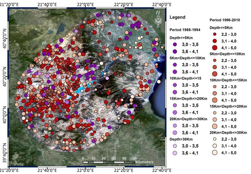
Kyriaki; JGEESI, 21(2): 1-10, 2019; Article no.JGEESI.49100

 protracted seismicity which is mainly located in the SW area of Polyphyto lake, has characteristics
 of the second type of induced seismicity according to Talwani [4], and seems to be controlled by the
 water level fluctuations of Polyphyto reservoir due to the mechanism of pore pressure diffusion.

Keywords: Triggering seismicity; induced seismicity; dams; North Greece.

1. INTRODUCTION                                          The first type is known as initial seismicity and
                                                         the second one as protracted seismicity.
Many study cases worldwide have been
associated with many strong earthquakes and              The main factors which have been associated
the reservoir impoundment as well as water               with the RIS are the maximum height of water
fluctuations in lake levels, such as in the region       level, the permeability of background, the
of the Leak Mead in Arizona, USA [5],                    amplitude of the reservoir water level fluctuations
Hsinfengkiang, China, [6,7], Kremasta, Greece,           as well as the periodicity [14], the impoundment
[8,9], Koyna, India, [10,11,4,12], Pournari,             rate, the value of pore pressure increase [15],
Greece, [13]. This association is known as               and the exceedance of lake levels over previous
Reservoir Induced seismicity (RIS) or Reservoir          maxima, a phenomenon known as ‘‘stress
Triggering Seismicity (RTS). According to                memory’’ [7,16,6].
Talwani [4] two main types of RIS are observed.

                                Fig. 1. Geological map of study area

                                                     2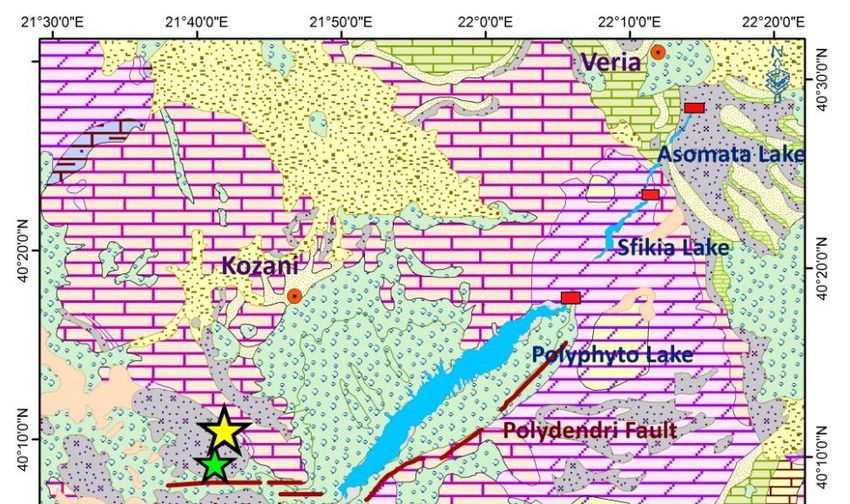
Kyriaki; JGEESI, 21(2): 1-10, 2019; Article no.JGEESI.49100

The study area belongs to the Pelagonian zone              earthquake ML=5.2 on 25 October 1984, NW of
which consists of metamorphic rocks (crystalline           the edge of Polyphyto lake with focal depth
substratum) covered by carbonate rocks and                 18Km, while the first filling of the second
flysch. The major geological structures which              downstream reservoir (Sfikia Dam, initial water
trend NW -SE along the Dinarides are                       level height 88 m and maximum 112m, maximum
intersected by the Servia active fault with ENE-           volume V=17.6X10⁶m3) started on 12 March
WSW direction [17,18]. The south-west part is              1985 and was completed at the end of August
covered        by      ophiolites   (Jurassic-Upper        1985.
Cretaceous) and molassic formations of the
Meso- Hellenic Trench while the northern part of           2. DATA AND METHODS
the broader area (up to 50 Km around the
artificial lakes) is covered by carbonate rocks that       We detailed investigated the correlation between
belong to the Axios zone and ophiolites. Plio-             the recorded seismicity and the daily rate of
Pleistocene deposits occupy the basin of Kozani            water level fluctuations (dh/dt) for the period
which is located on the west of the lakes.                 1974 – 2010, using the seismological data from
                                                           National Observatory of Athens catalogues
The main faults that dominate the broader                  (NOA), and the spatial and temporal distribution
Polyphyto reservoir area are: a) a 70 km long              of observed seismicity was studied for distances
fault zone which consists of several subparallel           0-10 km, 0-20 km, 0-30 km, 0-40 km, 10-20 km,
faults with ENE-WSW to NE-SW direction,                    20-30 km, 30-40 km and 40-50 km around the
parallel to the Polyphyto (Polydendri, Servia-             reservoir using the ESRI software ARCGIS 10
Velventos and Deskati fault) and b) the Rymnio,            (see details for seismological data on Mc, RMS,
Paleochori, Chromio-Vari, Pontini- Pilori and Feli         etc. in several author [2,3].
faults located SW of the edge of the lake, striking
in a E-W direction (Fig. 1.).                              2.1 Background         Seismicity                    and
                                                               Seismicity after Impoundment
Τhe observed seismicity of Aliakmona river area
(N Greece), upon which the Public Power
                                                           This area was classified as low seismicity until
Corporation (PPC) has established three
                                                           1995, when a strong earthquake of MS=6.5
reservoirs downstream of each other, with
                                                           occurred between the cities of Kozani and
Polyphyto Dam being the first largest with a dam
                                                           Grevena, at a distance of 18 Km from the
height of 112m, maximum water level height
                                                           southern point of the reservoir [1]. This focal area
h=289m, maximum volume V=1.220X10⁶m3 and
                                                           is near the earthquake ML=5.2 that took place on
first filling in January 1974, was investigated.
                                                           25 October 1984 during the Asomata reservoir
                                                           initial filling [27,23,24].
This area was classified as low seismicity until
1995, when a strong earthquake of MS=6.5                   During the period up to 1900, five major
occurred between the cities of Kozani and                  earthquakes occurred in the broader area with
Grevena, at a distance of 18 Km from the                   epicenters close to Veria (ML=6.0, 896-904 and
southern point of the reservoir [19,20,21]. This           ML=6.4, 1211-1236), Edessa (ML=6.7, 1395)
focal area is near to the earthquake ML=5.2 that           Kozani (ML=6.5, 1695) and Katerini (1889) [22]
took place on 25 October 1984 during the                                     th
                                                           [33,34]. In the 20 century, only two major events
Asomata reservoir initial filling [8,22,23,24,25].         (1922 December 7, M=5.4 and 1943 March 25,
According to several author [26,27,17], many               M=5.5) are located close to Preveza and Kozani
parts of Kozani and Grevena cities and a number            respectively [34,30].
of villages had been damaged by the mentioned
1995 earthquake. The latter event caused the               The spatial distribution of epicenters for the
disagreement about it was induced due to the               period commencing 10 years prior to the
first filling of the Polyphyto artificial lake or          impoundment of Polyphyto dam (first filling in
caused by tectonic movements [28,29,30,31,32,              1974) in comparison with the distribution for the
25].                                                       period 10 years after, indicates a noticeable
                                                           change in seismic activity in the vicinity of the
The impoundment of the third downstream                    artificial lakes for a distance up to 50Km. (Fig.
reservoir (Asomata Dam, initial water level height         2.a.). The increase of seismicity is remarkable
44m, and maximum 78m), which commenced on                  after the first filling of Polyphyto Dam (early
10 October 1984, was accompanied by an                     1974).

                                                       3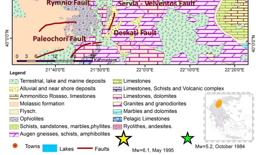
Kyriaki; JGEESI, 21(2): 1-10, 2019; Article no.JGEESI.49100

   Fig. 2. Spatial distribution map for period 1964-1983 for a distance up to 50Km around the
  three reservoirs (Polyfyto, Sfikia and Asomata) (a). Red circles illustrate the events for the
 period 1964 - 1973, while orange circles illustrate the events for the period 1974 to 1983 after
the impoundment of Polyphyto Dam (1974). Clusters with characteristics of induced seismicity
                                             (1986) (b)

 Fig. 3. Water level correlation is shown, with respect to the monthly seismicity for the period
  1984- 1987 (Polyphyto, Sfikia and Asomata) (a) as well as the correlation diagram between
 water level fluctuations of Polyphyto with respect to monthly seismicity for distances 10, 20
      and 30Km around the reservoirs (time period August 1987 to December 31, 2010) (b)

The initiation of the first filling of the Asomata       depth range between of 5-10Km, as well as
reservoir took place on 10 October 1984 and an           numerous microearthquakes north of Polyphyto
earthquake of magnitude ML=5.2 was recorded              reservoir. Noticeable seismicity was observed
on 25 October 1984, NW of the south edge of              north of Polyphyto Dam in the period of January
Polyphyto lake with focal depth 18Km, which was          1986, up to June 1986, while the water level of
accompanied by numerous microearthquakes. It             Polyphyto Lake was higher. This seismicity is
is remarkable that in this period, the Polyphyto         associated with higher rate of Polyphyto water
water level was at its lowest value. During the          level changes.
impoundment period of the second downstream
reservoir, Sfikia Dam, few small events were             An earthquake of magnitude ML=4.8 occurred on
observed close to the Sfikia artificial lake, in a       February 18, 1986, north of the lakes at a depth

                                                     4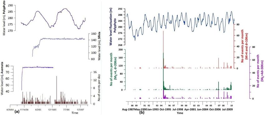
Kyriaki; JGEESI, 21(2): 1-10, 2019; Article no.JGEESI.49100
of 25 km (Fig. 2b, green ellipse). The b value of characterized as induced seismicity b value if
Gutenberg-Richter relation for the aftershock compared to the values that characterized the
sequence was calculated equal to b=1.056, while seismicity of the Koyna Dam area as induced
the expected b values for the region is between [10]. These values for the aftershock sequence
0.86≤b≤0.90 e.g. [35,20,36,37,9,38,39,40]. The of the major earthquake M0=6.0 in case of
ratio of the largest aftershock to the main shock Koyna Dam, were found Μ0-Μ1 = 0.8, Μ1/Μ0 =
magnitude was calculated equal to M1/M0=0.81, 0.83 and b=1.09 [9,16,10]. The same
while the difference between the major characteristics were detected in the second
aftershock to the highest aftershock was cluster as well (Fig. 2. b., light orange ellipse).
calculated M0-M1=0.9. This value b could be
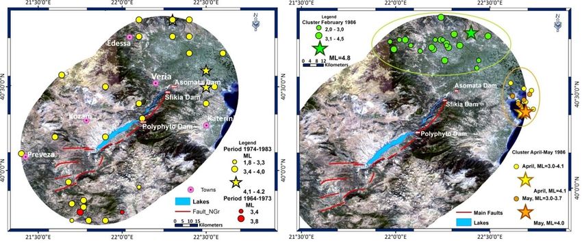
Fig. 4. Spatial distribution map for the period 1988-1994 and 1996-2010
Fig. 5. Evolution of the seismicity in the study area during the period June 2009 – May 2010
(2.5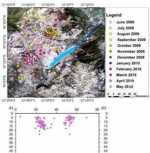
Kyriaki; JGEESI, 21(2): 1-10, 2019; Article no.JGEESI.49100

The distribution maps of epicenters for the period          of the Polyphyto reservoir, as well as the rate of
1987 to 2010 reveal that seismicity is mainly               water level changes [4,7].
confined to earthquakes with magnitudes
ML≤4.5, with the exception of the strong                    The correlation between the maximum or
earthquake that occurred on 13 May 1995 of                  minimum water level with respect to the
magnitude ΜW=6.5, in the area of Kozani, with               seismicity appears a time delay from one month
larger aftershocks of size ΜL=5.0 and ΜL=4.6,               to three months without systematic behavior and
and earthquakes of magnitude ML=5.0 on 9                    seems to depend on the rate changes of the
June, 2003 (18 Km depth, 49Km southeast of the              Polyphyto water level.
Polyphyto reservoir) and ML=4.9 on 17 July,
2007 (22 Km depth, Kozani area).                            3.1 Description of Observed Seismicity
2.2 Correlation between Seismicity and                      According to the spatial distribution of the
    Water Level                                             seismicity in the wider area for ML≥4.0 sizes,
                                                            seismic activity is observed which is confined
The potential correlation between seismicity (for           mainly to the SW and NE of the Polyphyto Lake.
radius of 50Km around the reservoir) and water              The distribution of seismic events of smaller
level fluctuation was investigated in two times             magnitude ML≤4.0 shows sporadic seismicity
windows. The first time window (a) concerns the             throughout the area of the Polyphyto (for a
initial impoundment of reservoirs Asomata and               distance 50Km around the lakes), which shows a
Sfikia which is April 1, 1984 until April 30, 1987,         higher density of seismic events south and west
and the second time window (b) concerns the                 of the Polyphyto lake (Fig. 4.).
period May 1, 1987 to Dec 31, 2010.
                                                            During the years 2009 and 2010, clusters of
Time window (a) During the period 10/10/1984 to             epicenters are observed to the Northwest of the
2/28/1985 112 seismic events with magnitude                 lakes (Fig. 5.). According to the cross section
1.2
Kyriaki; JGEESI, 21(2): 1-10, 2019; Article no.JGEESI.49100

region where it is located from May 1987 to              As mentioned in the description of seismicity
2010.                                                    during the years 2009 and 2010 clusters of
                                                         epicenters are observed to the north and south of
More specifically, the highest rate 67% of total         the reservoir while the water level was 289.03m
seismicity (1616 events for period 1987-2010)            and had been rising until 2010 which reached
occurred at depths of 0-5km, 11% at depths 6-            290,37m for the first time (Fig. 5). The above
10km and 6% at depths 11-15Km for a distance             exceedance of Polyphyto water level over
10km around the lakes, as well as high seismicity        previous maxima (290m) caused the activation of
rates with depth up to 5Km were also observed            the small pull apart basin, a phenomenon known
for the zones 10-20Km, 20-30Km and 30-40Km               as ‘stress memory’ [7,4,12,15].
in contrast to the area zone 40-50Km (Fig. 6).
                                                         A factor that enhances the effect of the pore
                                                         pressure diffusion, resulting in a decrease in the
                                                         shear strength of the fractures, is the fact that the
                                                         earthquake of magnitude ΜW=6.5 occurred on
                                                         May 13, 1995, ten years after the earthquake on
                                                         October 25, 1984, size ML=5.2. The presence of
                                                         two seismic events with ML>5 over a ten-year
                                                         period is in contradiction with the region's history.

                                                         Moreover, the possibility that the earthquake of
                                                         Kozani (May 13, 1995) be an accelerated event
                                                         in the area because of positive coseismic stress
                                                         coulomb transfer from previous strong earth-
                                                         quakes does not exist, since the activities of the
                                                         major earthquakes from 1902 to 1995 resulted in
                                                         the transfer of negative stresses in the study
                                                         area according to Pavlides and Mountrakis [41].

                                                         3.3 Discussion
   Fig. 6. Number of seismic events with
 magnitudes 2.2
Kyriaki; JGEESI, 21(2): 1-10, 2019; Article no.JGEESI.49100
to the reservoir during the third and fourth month correlation between Polyphyto water level and
after the impoundment, as well as a shallow monthly seismicity. This leads us to the
seismic activity with small magnitudes which are conclusion that there is a presence of protracted
located in the south edge of the Polyphyto induced seismicity which is the second type of
reservoir. induced seismicity according to Talwani [4] and
located mainly on the area SW of the Polyphyto
In the first semester of 1986, aftershock lake.
sequences were detected to the North of the
Asomata reservoir and to the east of the The possible reason for this seismic activity, in
Thermaic Gulf. These aftershock sequences this area where includes the Kozani earthquake
appear to have similar characteristics to the (May 13th, 1995), isn’t only due to the presence
Koyna dam area, which has been globally of the intensely ruptured area and the fractures
characterized as a case of induced seismicity. limestones but also to the direction of the faults
The statistical results of the investigation of the (almost perpendicular to the maximum axis of the
focal depths in a 50km distance around the lake) which favors the transfer of pore pressure
reservoirs show that the highest percentage took to the neighboring rocks in greater distances
place in depths up to h=5km, with the majority of through these permeable fault zones [15,6]. A
earthquakes taking place at distances between factor that enhances the effect of the pore
10-30 km around the lakes. The correlation pressure diffusion, resulting in a decrease in the
between the water level fluctuation and the shear strength of the fractures, is the fact that the
monthly seismicity rate for distance 10, 20, 30 earthquake of magnitude ΜW=6.5 occurred on
and 40km around the three (3) lakes shows that May 13, 1995, ten years after the earthquake on
the seismicity is associated with the water level October 25, 1984, size ML=5.2 [42]. The
fluctuations and rate of water level change. This presence of two seismic events with ML>5 over a
relationship appears with a time delay of one to ten-year period is in contradiction with the
three months. In the case of the Kozani region's history. Moreover, the possibility that the
earthquake (Mw = 6.5 which took place May 13, earthquake of Kozani (May 13, 1995) be an
1995) the Polyphyto reservoir high change rates accelerated event in the area because of positive
of water level fluctuation during the previous coseismic stress coulomb transfer from previous
seven months. Specifically, on September 10th, strong earthquakes does not exist, since the
1994 the Polyphyto level had a change rate of activities of the major earthquakes from 1902 to
dh/dt = 0.56m/day, on September 11th, 1994 a 1995 resulted in the transfer of negative stresses
change rate dh/dt = -0.64m/day, on January 3rd, in the study area according to Pavlides and
1995 a change rate dh/dt = 0.40m/day, on Mountrakis [41].
January 4th, 1995 a change rate dh/dt =
0.33m/day, on January 29th, 1995 a change rate COMPETING INTERESTS
dh/dt = 0.38m/day and on January30th, 1995 a
change rate dh/dt = 0.25m/day. Author has declared that no competing interests
th th
Specifically on September 10 and 11 , 1994, exist.
the Polyphyto water level had a rate of
dh/dt=0.56m/day and dh/dt=-0.64m/day, on REFERENCES
rd th
January 3 and 4 1995 had dh/dt=0.40m/day
and dh/dt=0.33m/day while on January 29th and 1. Pavlou K, Drakatos G, Kouskouna V,
30th, 1995 had dh/dt=0.38m/day and Makropoulos K, Kranis H. Seismicity study
dh/dt=0.25m/day respectively, a fact that leads to in Pournari reservoir area (W. Greece)
an increase in the effective pore pressure. The 1981-2010. J Seismol; 2016.
comparison of these high daily values of rate DOI: 10.1007/s10950-016-9552-1
change with the usual low values leads to the 2. Comninakis P, Drakopoulos J,
conclusion that the seismicity is possible due to Moumoulidis G, Papazachos B. Foreshock
the change of the pore pressure owing to the and aftershock sequences of the Kremasta
high change rate of the water level of Polyphyto earthquake and their relation to the water
[16,11,15,6]. loading of the Kremasta artificial lake. Ann
Geofis. 1968;21:40-71.
4. CONCLUSION 3. Mogi K. Some discussions on aftershocks,
foreshocks and earthquake swarms -The
A relationship is observed between spatial fracture of a semi- Infinite body caused by
distribution maps of epicenters as well as the an inner stress origin and its relation to the
8Kyriaki; JGEESI, 21(2): 1-10, 2019; Article no.JGEESI.49100
earthquake phenomena. Bull Earthq Res 17. Lekkas E, Fountoulis I, Lozios S, Kranis
Inst, University of Tokyo. 1963;41:615- CH, Adamopoulou E. Neotectonic implica-
658. tions of Grevena - Kozani earthquake (May
4. Talwani P. Seismogenic properties of the 13, 1995, W. Macedonia, Greece).
crust inferred from recent studies of International meeting on results of the May
reservoir-induced seismicity - Application 13, 1995 earthquake of West Macedonia:
to Koyna. Current Science. 2000;79(9): One year after, INQUA. 1996b;76-80.
1327-1333 18. Li ZA, Xu YJ, Xan XG. Discussion on the
5. Carder DS. Seismic investigation in the environmental factors of the induced
Boulder Dam area, 1940-1944, and the earthquakes. In crust deformation and
influence of reservoir loading on earthquakes. Ed. Institute of Seismology,
earthquake activity. Bull Seismol Soc Am. S.S.B. Seismological Press, Beijing. 1989;
1945;35:175-192. 140-147.
6. Withers RJ, Nyland E. Theory for rapid 19. Papanastasiou D, Drakatos G, Voulgaris
solution of ground subsidence near N, Stavrakakis G. The May 13, 1995,
reservoirs on layered and porous media. Kozani - Grevena (NW Greece)
Eng. Geol. 1976;10:169-185. earthquake: Source study and its tectonic
7. Talwani P. Speculation on the causes of implications. Journal of Geodynamics.
continuing seismicity near Koyna reservoir, 1998; 26(2- 4):233-244.
India. Pure and Applied Geophysics. 1995; 20. Papazachos BC. The time distribution of
145(1):168-174. the reservoir associated foreshocks and its
8. Drakatos G. Relative seismic quiescence importance to the prediction of the principal
before large aftershocks. Pageoph. 2000; shock. Bull Seism Soc Am. 1973;63:1973-
157:1407-1421. 1978.
9. Durá-Gómez I, Talwani P. Hydro- 21. Papazachos BC, Papazachou CB. The
mechanics of the Koyna–Warna Region, earthquakes of Greece. Book, Ziti,
India. Pure Appl. Geophys; 2009. Thessaloniki; 2003.
DOI: 10.1007/s00024-009-0012-5 22. Paradisopoulou PM, Papadimitriou EE,
10. Gupta HK. The present status of reservoir Karakostas VG, Lasocki S, Mirek J, Kilias
induced seismicity investigations with A. Influence of stress transfer in probability
special emphasis on Koyna earthquakes. estimates of M>=6.5 earthquakes in
Tectonophysics. 1985;118:257-279. Greece and surrounding areas. Bulletin of
11. Talwani P. On the νature of reservoir- the Society of Greece, Proceedings of the
induced seismicity. Pure and Applied 12th International Congress. Patras; 2010.
Geophysics. 1997;150(3-4):473-492. 23. Makropoulos K, Burton P. Seismic hazard
12. Talwani P, Chen L, Gahalaut K. in Greece. I. Magnitude recurrence. Tecto-
Seismogenic permeability, KS. J Geophys nophisics. 1985a;117:205-257.
Res; 2007. 24. Makropoulos K, Kaviris G, Kouskouna V.
DOI: 10.1029/2006JB004665 An updated and extended earthquake
13. Simpson DW, Leith WS Scholz CH. Two catalogue for Greece and adjacent areas
types of reservoir-induced seismicity. since 1900. Nat. Hazards Earth Syst. Sci.
Bulletin of the Seismology Society of 2012;12:425-1430.
America. 1988;78(6):2025–2040. 25. Pavlou K, Kaviris G, Chousianitis K,
14. Hatzfeld D, Nord J, Paul A, Guiguet R, Drakatos G, Kouskouna V, Makropoulos K.
Briolle P, Ruegg JC, et al. The Kozani- Seismic hazard assessment in Polyphyto
Grevena (Greece) earthquake of May 13, Dam area (NW Greece) and its relation
1995, Ms=6.6. Preliminary results of a field with the “unexpected” earthquake of 13
multidisciplinary survey. Seismological May 1995 (Ms = 6.5, NW Greece). Nat
Research Letters. 1995;66(6):61-70 Hazards Earth Syst Sci; 2013.
15. Wang M, Hu Y, Yang M, Li T, Chin Y, Feng DOI: 10.5194/nhess-13-141-2013
J. Mechanism of the reservoir impounding 26. Carydis P, Holevas K, Lekkas E,
earthquakes at Hsinfengkiang and a Papadopoulos T. The Grevena central -
preliminary endeavor to discuss the cause. North) Greece earthquake series of May
Eng Geol. 1976;10:331-351. 13, 1995. EERI Newsletter. Special
16. Gupta HK, Rastogi BK. Dams and Earthquake Report. California. 1995;29(6):
earthquakes. Elsevier 229; 1976. 1-4.
9Kyriaki; JGEESI, 21(2): 1-10, 2019; Article no.JGEESI.49100
27. Chouliaras G. Investigating the earthquake earthquakes in Corinthos Gulf, Central
catalog of the National Observatory of Greece. Physics and Chemistry of the
Athens. Nat. Hazards Earth Syst. Sci. Earth. 2000;25(3):239-245.
2009;9:905–912. 36. Papazachos BC. On the relation between
28. Pavlides SB, Zouros NC, Chatzipetros AA, certain artificial lakes and the associated
Kostopoulos DS Mountrakis DM. The 13 seismic sequences. Eng Geology. 1974;8:
May 1995 western Macedonia, Greece 39-48.
(Kozani-Grevena) earthquake; preliminary 37. Papazachos CB. An alternative method for
results. Terra Nova. 1995;7:544-549. a reliable estimation of seismicity with an
29. Pavlou K. Seismic activity and induced application in Greece and surrounding
seismicity in Greece. Dissertation, area. Bull Seism Soc Am. 1999;89:111-
University of Athens; 2011. 119.
30. Kourouzidis MC. Study of seismic 38. Drakatos G, Latoussakis J. Some features
sequences in Greece and its contribution of aftershock patterns in Greece. Geo-
to earthquake prediction. Dissertation, physical Journal International. 1996;126:
University of Thessaloniki; 2003. 123-134.
31. Gupta HK. A review of recent studies of 39. Lekkas E, Kranis Ch, Fountoulis I, Lozios
triggered earthquakes by artificial water S, Adamopoulou E. Spatial distribution of
reservoirs with special emphasis on damage caused by the Grevena - Kozani
earthquakes in Koyna, India. Earth- earthquake (W. Macedonia) of May 13,
Science Reviews. 2002;58:279-310. 1995. International meeting on results of
32. Papazachos BC. Aftershock activity and the May 13, 1995 earhquake of West
aftershock risk in the area of Greece. Ann Macedonia: One year after, INQUA,
Geofis. 1971;24:439- 456. 1996a;89-92.
33. Ambraseys N. Earthquakes in the 40. Drakopoulos J. Focal mechanism and
Mediterranean and Middle East – A seismicity triggering in the Kremasta –
multidisciplinary study of seismicity up to Kastraki dam area (Greece). Post Doc
1900. University of Cambridge; 2009. Thesis, Athens University; 1974.
34. Mignan A, Chouliaras G. Fifty years of 41. Pavlides S, Mountrakis D. Extensional
seismic network performance in Greece tectonics of northwestern Macedonia,
(1964–2013): Spatiotemporal evolution of Greece, since the Late Miocene. J. Struct.
the completeness magnitude. Seismo- Geol. 1987;9(4):385-392
logical Research Letters. 2014;85(3):657– 42. Makropoulos K, Burton P. Greek tectonics
667. and seismicity. Tectonophisics. 1984;106:
35. Papadopoulos G, Drakatos G, Plessa A. 275-304.
Foreshock activity as a precursor of strong
_________________________________________________________________________________
© 2019 Kyriaki; This is an Open Access article distributed under the terms of the Creative Commons Attribution License
(http://creativecommons.org/licenses/by/4.0), which permits unrestricted use, distribution, and reproduction in any medium,
provided the original work is properly cited.
Peer-review history:
The peer review history for this paper can be accessed here:
http://www.sdiarticle3.com/review-history/49100
10You can also read