Strategy for Victoria's positioning system 2021-2025
←
→
Page content transcription
If your browser does not render page correctly, please read the page content below
Strategy for Victoria’s
   positioning system
               2021-2025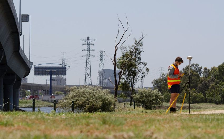
Acknowledgment
   We acknowledge and respect Victorian Traditional Owners as the
   original custodians of Victoria's land and waters, their unique
   ability to care for Country and deep spiritual connection to it.
   We honour Elders past and present whose knowledge and wisdom
   has ensured the continuation of culture and traditional practices.
   We are committed to genuinely partner, and meaningfully engage, with
   Victoria's Traditional Owners and Aboriginal communities to support the
   protection of Country, the maintenance of spiritual and cultural practices
   and their broader aspirations in the 21st century and beyond.

Front cover image: Mount Emu GNSS CORS.

© The State of Victoria Department of Environment, Land, Water and Planning 2020

This work is licensed under a Creative Commons Attribution 4.0 International licence. You are free to re-use the
work under that licence, on the condition that you credit the State of Victoria as author. The licence does not apply
to any images, photographs or branding, including the Victorian Coat of Arms, the Victorian Government logo
and the Department of Environment, Land, Water and Planning (DELWP) logo. To view a copy of this licence, visit
creativecommons.org/licenses/by/4.0/
ISBN 978-1-76105-342-9 (Print)
ISBN 978-1-76105-343-6 (pdf/online/MS word)
Disclaimer
This publication may be of assistance to you but the State of Victoria and its employees do not guarantee that the
publication is without flaw of any kind or is wholly appropriate for your particular purposes and therefore disclaims all
liability for any error, loss or other consequence which may arise from you relying on any information in this publication.

Accessibility
If you would like to receive this publication in an alternative format,
please telephone the DELWP Customer Service Centre on 136 186, or email
customer.service@delwp.vic.gov.au, or via the National Relay Service on 133 677,
www.relayservice.com.au. This document is also available on the internet
at www.delwp.vic.gov.au
Department of Environment, Land, Water and Planning

Foreword

Immediate and effortless access to spatial
information is a feature of the modern world.

Precise and detailed spatial information supports      The Department of Environment Land Water and
effective management of land and marine resources,     Planning (DELWP), through the Surveyor-General
and this is essential to the community, economy        Victoria (SGV) Geodesy section, is responsible
and environment.                                       for managing Victoria’s positioning infrastructure
                                                       and information. SGV Geodesy is leading the
Underpinning all spatial information is an accurate    development and implementation of the AGRS
and reliable system of positioning. This supports      modernisation program in Victoria, which is
seamless interaction with independently sourced        highlighted as a major initiative in the Strategic
spatial information. Positioning has been identified   Land Assessment and Information Strategy 2030
by ANZLIC – the Australian and New Zealand Spatial     and SGV Strategic Plan 2020-2025. The SGV
Information Council – as the fundamental layer of      strategy outlines the priorities for SGV Geodesy
foundation spatial information used by government,     in maintaining and enhancing Victoria’s positioning
business and the community.                            infrastructure and information to ensure business
                                                       and the community get maximum benefit from
The ANZLIC Strategic Plan 2020-2024 highlights
                                                       advances in positioning.
a major five-year initiative to modernise the
Australian Geospatial Reference System (AGRS).
This national program is being delivered through
the Intergovernmental Committee on Surveying           Melissa Harris
and Mapping (ICSM). The purpose of the program         Acting Chief Executive
is to support advancements in precise positioning      Land Use Victoria
and enhance alignment with underlying spatial          ANZLIC Deputy-Chair
information. It recognises the increased reliance
on positioning, community safety and productivity
gains, and encourages innovation.                      Craig Sandy
                                                       Surveyor-General of Victoria
                                                       Roger Fraser
                                                       Chief Geospatial Scientist
                                                       Joint ICSM Representatives, Victoria

                                                             Strategy for Victoria’s positioning system 2021-2025   1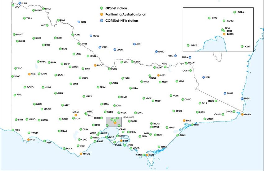
Department of Environment, Land, Water and Planning

Surveyor-General Victoria
Geodesy

SGV Geodesy has the governmental responsibility for
providing access to an accurate and reliable system
of positioning across Victoria. We do this by maintaining
and enhancing positioning infrastructure and information
services. These enable precise positioning and alignment
of spatial information with the national coordinate
reference system. The table below lists the major
services provided by SGV Geodesy.

    Products and services          Dimensions

    Primary positioning            Integrated, state-wide network of Global Navigation Satellite
    infrastructure and             System (GNSS) Continuously Operating Reference Stations (CORS)
    data services (GPSnet)         that collect positioning data and distribute real-time data streams
                                   to enable precise positioning services.

    Survey control                 State-wide network of more than 170,000 survey control marks
    infrastructure                 to support the surveying and spatial industry. Survey mark
    and information                information is made available at no cost through an interactive
                                   online application, the Survey Marks Enquiry Service (SMES).

    High precision                 Specialised surveying services provided across Victoria to
    surveying services             extend the survey control mark network and monitor changes
                                   in physical features.

    Survey equipment               Facilities for surveyors to calibrate electronic distance measuring
    calibration services           equipment to confirm its accuracy and enable traceability to the
                                   national standard for length.

    Advisory                       Freely available specialist, authoritative advice and support
    services                       in relation to positioning infrastructure and information.
                                   Represent Victoria in national geodesy and positioning forums.

    Stakeholder                    Collaboration with stakeholders to ensure positioning infrastructure
    engagement                     and information services meet their needs. Educational
    and education                  presentations and promotion of geodesy and positioning.

2        Strategy for Victoria’s positioning system 2021-2025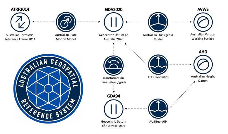
Department of Environment, Land, Water and Planning
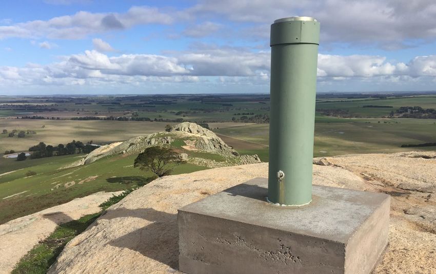
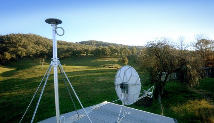
Regional GNSS CORS with satellite communications.
Victoria’s GNSS CORS network.
Strategy for Victoria’s positioning system 2021-2025 3
Department of Environment, Land, Water and Planning

Expanding role                                                Major national programs
SGV Geodesy has supported surveying and                       Over the next five years, SGV Geodesy will
mapping in the state since the initial Geodetic               continue its work for major national programs
Survey of Victoria in the 1860s. This has been mainly         designed to enable government, businesses
through maintaining and enhancing geodetic                    and the community to gain maximum benefit
or survey control infrastructure and information.             from advances in positioning technology. Through
                                                              collaborative arrangements, SGV Geodesy will
Recognising the capability of precise positioning,            lead and support the implementation of these
support for the surveying and spatial industry                national programs in Victoria.
broadened to include providing satellite positioning
infrastructure and information services from the              1.	Australian Geospatial Reference System
1990s. Additional industries have benefited from
                                                                  (AGRS) modernisation
adopting precise positioning services, including
construction, agriculture, transport, scientific              ANZLIC and ICSM have endorsed a strategic program
research, asset and resource management                       to update the fundamental components of the
and other location-based services                             national coordinate reference system, featuring:

The positioning system supports precise                          •	GDA2020 – Geocentric Datum of Australian
                                                                    2020 (GDA2020)
positioning, seamless integration of spatial
information and increased productivity for                       •	ATRF2014 – Australian Terrestrial Reference
businesses and the Victorian community.                             Frame
                                                                 • AVWS – Australian Vertical Working Surface

                                                              The AGRS modernisation program will enhance
                                                              alignment with the International Terrestrial
                                                              Reference Frame and enable seamless interaction
                                                              between precise positioning technology and
                                                              spatial information.

4      Strategy for Victoria’s positioning system 2021-2025             AGRS modernisation components.
Department of Environment, Land, Water and Planning

GNSS surveying Victoria’s highest peaks.

2. Positioning Australia                                   Major projects in Victoria
The Positioning Australia Program, led by
Geoscience Australia, will deliver a national precise      SGV Geodesy will collaborate and support major
positioning capability. It is designed to accelerate       Victorian programs including:
adoption and facilitate innovation in positioning
                                                              • Digital cadastre modernisation (DCM) project
technology and applications. The program includes:
                                                              •	State-wide LiDAR observation for Vicmap
   •	National Positioning Infrastructure Capability             elevation products
      which will support 3cm accuracy precise                 • Major infrastructure projects
      positioning anywhere in Australia where
                                                              • Digital twin
      there is internet coverage.

   •	Southern Positioning Augmentation Network
      which is planned to be operational by 2023
      and will provide instant access to 10cm
      accuracy positioning across the Australia/
      New Zealand region.

GNSS surveying to support major infrastructure projects.

                                                                 Strategy for Victoria’s positioning system 2021-2025   5
Department of Environment, Land, Water and Planning

                                                                                               Precison agriculture
                                                                                               Support auto steer
                                                                                               farming operations
                                                                                               for cropping,
                                                                                               spraying, harvesting

Applications that benefit                                                                      and crop mapping.

from precise positioning
                                                              Water management
                                                              and irrigation
                                                              Enhanced surveying,
                                                              construction and monitoring
                                                              of irrigation infra- structure
                                                              to improve water resources
                                                              allocation efficiency.

                Science and                    Construction             Transport and
                earth monitoring               Guiding heavy            intelligent vehicles
                Monitoring sea                 machinery                Integrated into all
                level change,                  operations on road,      forms of transport
                land motion and                rail and other           including aviation,
                changes in the                 infrastructure           maritime, road
                atmosphere.                    projects.                for autonomously
                                                                        controlled vehicles.

6      Strategy for Victoria’s positioning system 2021-2025
Department of Environment, Land, Water and Planning

Emergency services               Surveying                Mining
Enhanced rescue                  Accurate surveying       Guiding heavy
operations,                      of property              machinery operations
improved hazard                  boundaries, natural      and supporting
risk modelling                   features, assets         autonomous haulage.
and safety of life               and infrastructure.
applications.

                     Location based            Mapping                        GNSS ground stations
                     services                  Enhanced capture of            Enabling precise
                     Improved personal         spatial information            positioning and
                     navigation and            such as imagery and            ensuring alignment
                     interaction with          elevation products.            with spatial
                     spatial information.                                     information and the
                                                                              underlying coordinate
                                                                              reference system.

                                                       Strategy for Victoria’s positioning system 2021-2025   7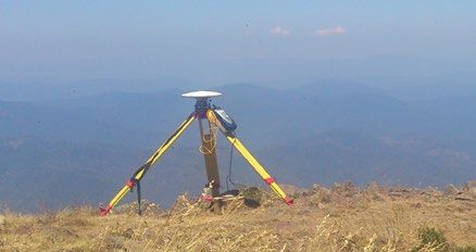
Department of Environment, Land, Water and Planning

Vision                                                        2. Positioning
                                                              SGV Geodesy will manage the operation,
SGV Geodesy’s vision is accurate, reliable                    maintenance and enhancement of Victoria’s
and accessible positioning for Victoria.                      primary positioning infrastructure and information
                                                              services. Central to this priority is our work to:

Strategic priorities                                             •	Contribute to the Positioning Australia
                                                                    program and provide free and open access
                                                                    to Victorian CORS network positioning data.
To achieve this vision for Victoria,
                                                                 •	Maintain high quality Victorian CORS
SGV Geodesy will lead and collaborate                               network infrastructure, including:
in programs linked to the following
                                                              		   - 	Ongoing CORS infrastructure
strategic priorities.
                                                                       maintenance, upgrades and equipment
                                                                       refreshment program.
1. AGRS modernisation
                                                              		   -	Upgrade to next generation communication
SGV Geodesy will lead the development and                             technologies and provide additional
implementation of the AGRS modernisation                              communications redundancy to
program in Victoria. Major activities include:                        increase reliability.
    •	Technical development, and implementation              		   -	Enhance the density of CORS to
       of GDA2020, ATRF and AVWS.                                     support development in regional and
                                                                      metropolitan growth areas and other
    •	Procurement of airborne gravity data                           major infrastructure projects.
       over targeted regions of Victoria to
       enhance the AVWS and the vertical                         •	Enhance positioning data integrity and the
       accuracy of precise positioning.                             use of Information and Communications
                                                                    Technology (ICT), including:
    •	Contribute to the ICSM Geodesy Working
       Group, support national initiatives                    		   -	Migration of the GNSS CORS data centres
       and collaborate across borders.                                to the cloud with a heavy focus on IoT.
    •	Develop applications and processes to                  		   -	Implement the latest fit-for-purpose
       support efficient delivery of spatial data                     data protocols to securely deliver CORS
       and transformation of data between datums.                     data and safeguard data integrity.
    •	Research and development of deformation                		   -	Contribute to the Asia-Pacific Reference
       models for targeted regions of Victoria.                       Frame as a GNSS CORS processing
                                                                      analysis centre, with a focus on CORS
                                                                      position monitoring.

                                                              		   -	Maintain high standard of CORS
                                                                      operation and enhance reporting
                                                                      of GNSS CORS performance against
                                                                      Service Level Agreements and
                                                                      Key Performance Indicators

8      Strategy for Victoria’s positioning system 2021-2025
Department of Environment, Land, Water and Planning
3. Survey control • Enable licensed surveyors to align cadastral
surveys with the national coordinate reference
SGV Geodesy will manage the maintenance system to meet the regulatory requirements of:
and enhancement of survey control infrastructure
and information in order to: - Surveying (Cadastral Surveys)
Regulations 2015
• Enhance survey control network infrastructure:
- Survey Co-ordination Regulations 2014
- In consultation with the surveying industry,
proactively extend the survey control • Support calibration of electronic
network to meet monumentation and distance measuring equipment
mark density requirements. for the surveying industry.
- Protect survey control mark infrastructure 4. Stakeholder engagement and education
and provide advice and resources for
survey control mark maintenance. SGV Geodesy will engage with stakeholders and
ensure they are informed and have the capability
- Collaborate and support state-wide digital to capitalise from advances in positioning.
transformation and digital engineering Core components of this strategy are to:
projects such as DCM, LiDAR data capture
and major infrastructure development. • Maintain strong and responsive relationships
with all stakeholders:
• Improve survey control mark information
maintenance and delivery: - Provide expert advice and simplify
complex concepts and technology.
- Improve SMES user experience,
access and delivery processes. - Identify new stakeholders and collaborate
with stakeholders to achieve enhanced
- Migration to scalable, cloud-based outcomes.
technologies and standards to support
seamless SMES data delivery. • Support education and training through:
- Contribute to national spatial - Universities with presentations, research
data infrastructure development projects, internships, mentoring, and
and implementation. contribute to curriculum development.
- Enhance analysis tools to improve - Presentations and training resources
management of survey control data to stakeholders on products and
and metadata. services as well as major initiatives.
- Contribute to the development and • Contribute to research and development:
implementation of eGeodesy to support
increased automation of processes - Continually monitor national and
(data processing, national adjustment). international geodetic and positioning
research, standards and practices.
- Improve processes for the submission of
survey measurements from the surveying - Develop and actively contribute to research
industry (including Government) to to improve the delivery of positioning
collaboratively maintain Victoria’s SCN. infrastructure and information services.
- Continue to develop skills, expertise and
capability of SGV Geodesy personnel.
Strategy for Victoria’s positioning system 2021-2025 9Want to know more? Geodesy Surveyor-General Victoria Strategic Land Assessment and Information Land Use Victoria Department of Environment Land Water and Planning T: 03 9194 0770 E: smes.support@delwp.vic.gov.au or gpsnet.support@delwp.vic.gov.au W: www.propertyandlandtitles.vic.gov.au/geodesy delwp.vic.gov.au
You can also read