Sustainable Water Management Strategy - North Salt Spring Waterworks District June 2015 - North Salt Spring ...
←
→
Page content transcription
If your browser does not render page correctly, please read the page content below
Sustainable Water
Management Strategy

  North Salt Spring Waterworks District
                                 June 2015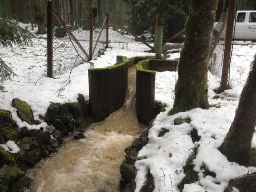
NSSWD Sustainable Water Management Strategy

CONTENTS
 Introduction ........................................................................................................ 1
 Background ......................................................................................................... 2
    Maxwell Lake Supply ...................................................................................... 2
     St. Mary Lake Supply ...................................................................................... 3
 Objectives ........................................................................................................... 5
 Conclusion .......................................................................................................... 8
 Appendix A – 2014 NSSWD Water Audit & Demand Charts .............................. 10
 References ........................................................................................................ 15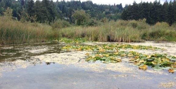
NSSWD Sustainable Water Management Strategy

                         North Salt Spring Waterworks District
                      Sustainable Water Management Strategy

Introduction
North Salt Spring Waterworks District (the District) is an
Improvement District on Salt Spring Island (SSI), the largest of the
southern Gulf Islands off the south-east coast of Vancouver Island.
From St. Mary and Maxwell Lakes, the District provides potable
water to the village of Ganges and much of the north end of SSI.
The District has more than 1700 connections to residential,
institutional, commercial and industrial customers including the
                                                                           Water
hospital, schools, restaurants, hotels, and private homes. In 2013,
                                                                           resources on
the District sold more than 500,000 m3 of water which equates to
                                                                           SSI are
the typical usage of approximately 2553 local single family homes
                                                                           already
or 5500 people.
                                                                           vulnerable to
In 2010, the BC Ministry of Environment released Preparing for             drought and
Climate Change: British Columbia’s Adaptation Strategy in which            climate
they revealed their vision for a resilient province and the strategic      change
approach for realizing that vision. The strategy clearly states that       impacts could
adaptation will be integrated into all government policy, legislation      make the
and regulations and that the Province must work with other levels          situation even
of government to achieve common goals.                                     more
                                                                           precarious.
As a local government organization, the District heard the message
loud and clear. Over-allocation of our limited resources would
place our community at risk and the District firmly believes that a
precautionary approach is warranted.
In 2013, the District engaged the services of Kerr Wood Leidal
Consulting Engineers to assess the water availability and demand
of both St. Mary and Maxwell Lakes. For each source, the
completed report contains a water budget under current and
future climate conditions for both an average rainfall year and a 1

                                                                               Page 1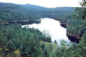
NSSWD Sustainable Water Management Strategy

in 10 year drought. Both reports contain a number of important
conclusions and recommendations that the District plans to             Drawdown
address. Moreover, both reports clearly define the current             of a lake
maximum licenced withdrawal limit as the maximum capacity of           beyond its
each source to supply water. This means neither lake has the           typical
capacity to support future withdrawals beyond the current              seasonal low
licenced amounts. The District has developed the following             level can
management strategy to ensure a sustainable water supply for our       negatively
community now and in the future.                                       impact both
                                                                       water
Background                                                             quality and
                                                                       fish habitat.
MAXWELL LAKE SUPPLY

                                                                       Water
                                                                       rights on St.
                                                                       Mary Lake
                                                                       are fully
                                                                       allocated
                                                                       too, so
                                                                       there will be
                                                                       no further
                                                                       licenses
The District is the sole water licensee on Maxwell Lake. When the      issued to
lake level was raised in 2000, the District obtained licences to       the District.
divert two seasonal creeks (Rippon Creek and Larmour Creek) from
adjacent watersheds into Maxwell Lake because there was
insufficient precipitation in the catchment area to refill the lake
each year. Currently, the District does not withdraw the full
licenced amount; however, there are undeveloped properties on
the Maxwell system and the unused portion of the licence is
reserved for those properties.

                                                              Page 2
NSSWD Sustainable Water Management Strategy

        The Maxwell Lake hydrology report confirms that Maxwell Lake
        can support withdrawal of the District’s full licence in both an
                                          average year and a one in ten year
                                          drought. However, the report also
                                          identifies that after a one in ten
                                          year drought, it could take up to                    Water rights
                                          four years of greater than average                   on St. Mary
rsion            Rippon Creek Diversion   precipitation to refill the lake. It is              Lake are fully
                                          also important to note that a one in                 allocated so
                                          ten year drought does not                            there will be
        necessarily occur only every ten years. As the climate changes, the                    no further
        level of precipitation that constitutes a one in ten year drought                      licences
        may occur more frequently. It is critical that Maxwell Lake be                         issued to the
        prevented from excessive drawdown due to the risk of not                               District.
        refilling; therefore, the report recommends capping withdrawal at
        72% of the total annual licence.

        ST. MARY LAKE SUPPLY
        Water rights on St. Mary Lake
        are fully allocated so there will
        be no further licences issued to
        the District. The District does
        not currently withdraw the full
        licenced amount, but there are
        undeveloped properties on the
        St. Mary system and the
                                               St. Mary Lake (Courtesy: Gulf Island Guide)
        unused portion of the licence is
        reserved for those properties. This means that there may not be
        any water left to serve new development within the District in the
        future.
        Drawdown of a lake beyond its typical seasonal low level can
        negatively impact both water quality and fish habitat, thus the
        Ministry of Forests, Lands, and Natural Resource Operations
        (MFLNRO) required the District to raise the lake level in order to

                                                                                      Page 3
NSSWD Sustainable Water Management Strategy
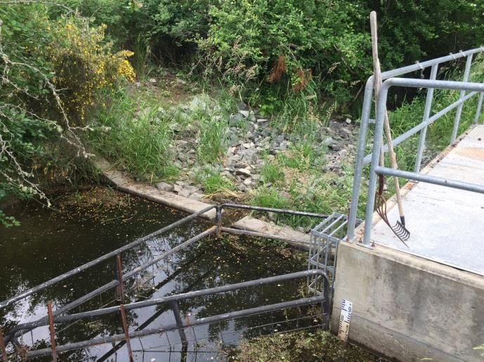
obtain an additional water licence in 2005. As a result, the Duck
Creek weir was constructed to create more storage.
Even with the
In exchange for the additional withdrawal licence, the District was
weir height at
also required by the Department of Fisheries and Oceans to
41.0 m ASL,
maintain minimum environmental flows in Duck Creek year-round.
the additional
This was accomplished by constructing a fish ladder adjacent to
storage will
the weir. The provision of year-round flow to Duck Creek has
be sufficient
resulted in a substantial improvement in fish habitat.
to service the
In 2006, the weir was properties
installed at an elevation that are
of 40.7 m above sea currently on
level1. However, prior to the District
2006, beaver dams kept tax roll but
the winter lake level at may not be
about 41.0 m even able to
though the natural outlet support any
is lower. Therefore, additional
construction of the weir development.
Duck Creek Weir
effectively lowered the
peak lake level from
approximately 41.0 m to 40.7 m. This means that there is less
water in St. Mary Lake now than before 2006, but the District is
still committed to maintaining year-round fish flows in Duck Creek.
The District is not permitted to
allow the lake level to fall below
40.0 m because minimum flows
through the fish ladder cannot
be maintained below that level.
It is important to note that
South end of St. Mary Lake with algal bloom
there are serious consequences
for failing to maintain fish flows or drawing the lake down below
40.0 m. Under the Water Act, the District’s water licence can be
1
Elevations measured using the Geodetic Survey of Canada datum.
Page 4NSSWD Sustainable Water Management Strategy
suspended or cancelled if the District does not comply with either
condition.
During the summer drought of 2014, the District was able to
maintain the lake level above 40.0 m due to voluntary
conservation by ratepayers. The situation made it clear that St.
Mary Lake cannot accommodate any additional demand until the
weir is raised to 41.0 m. Furthermore, even with the weir height at
41.0 m, the additional storage will be sufficient to service the
properties that are currently on the District tax roll but may not be
able to support any additional development.
Objectives
Item # Description Complete In Next
Progress Steps
Objective #1 Define the source capacity of St. Mary and Maxwell Lakes.
Action: The hydrology reports have defined the capacity and √
confirmed that neither lake can support withdrawals above
the current licenced volumes.
Objective #2 Compare the available supply to current demand and the
maximum licenced withdrawal.
Action: The Maxwell Lake Hydrology Report determined that √
Maxwell Lake can meet current and licenced demand but
may not be able to support any additional demand.
Action: The St. Mary Lake hydrology report determined that St. √
Mary Lake cannot support any additional demand until the
weir is raised to 41.0 m. The report has also confirmed that
St. Mary Lake can support the total licenced withdrawal
once the weir height is 41.0 m but cannot support any
additional demand.
Objective #3 Limit new demand until storage in St. Mary Lake has been
increased.
Page 5NSSWD Sustainable Water Management Strategy
Item # Description Complete In Next
Progress Steps
Action: A moratorium on new service has been implemented and √
will continue until the weir is raised to 41.0 m.
Objective #4 Assess the potential impacts of climate change on both
water sources.
Action: The hydrology reports determined that both water sources √
are at risk due to drought both now and under future
climate change scenarios.
Objective #5 Assess the potential impacts of drought on both water
sources.
Action: The hydrology reports determined that both sources are √
extremely vulnerable to drought and that Maxwell may not
refill for several years after a drought.
Objective #6 Measure bulk water withdrawals and ratepayer
consumption.
Action: The District is fully metered in both St. Mary and Maxwell √
water systems.
Objective #7 Identify and address system trends and losses.
Action: The District conducts an annual water audit. √
Action: The District has a proactive leak detection program. √
Objective #8 Adopt accounting procedures that enable detailed water
demand analysis.
Action: A new accounting program has been implemented to allow √
detailed demand analysis by system and sector.
Objective #9 Reduce system losses from reservoir overflows.
Action: Automated reservoir level control has been installed in √
Maxwell system.
Page 6NSSWD Sustainable Water Management Strategy
Item # Description Complete In Next
Progress Steps
Objective Encourage conservation through the use of a volumetric, √
#10 increasing-block rate structure.
Action: The District has had a volumetric rate structure in place for
many years and introduced conservation-oriented
increasing block pricing in 2014.
Objective Reduce outdoor water use during the summer.
#11
Action: Develop and implement a staged water restrictions bylaw √
by May 2015.
Objective Reduce demand from outside District boundaries.
#12
Action: End bulk water sales by May 31, 2015. √
Objective Prepare for dealing with the impacts of drought.
#13
Action: Develop a Drought Response Plan with a draft to be √
completed by September 2015.
Objective Confirm and refine understanding of water balances at
#14 both sources.
Action: Install continuous, real-time lake level and climate √
monitoring at St. Mary and Maxwell Lakes by June 2015.
Action: Install continuous, real-time monitoring of St. Mary Lake √
outflow to Duck Creek by end of 2015.
Objective Increase storage in St. Mary Lake to allow withdrawal of
#15 full licenced amount.
Action: Raise the Duck Creek weir elevation to 41.0 m. √
Objective Size infrastructure to match available supply.
#16
Page 7NSSWD Sustainable Water Management Strategy
Item # Description Complete In Next
Progress Steps
Action: Design and construct the proposed St. Mary Lake treatment √
facility to supply the full licenced volume.
Objective Clearly define undeveloped properties to which the District
#17 will provide service and the process for deciding which
properties are eligible.
Action: Develop a list of undeveloped and under-developed √
properties on the District tax roll and a queue for those
requesting service.
Objective Improve understanding of potential demand at full build-
#18 out in Official Community Plan.
Action: Assist Islands Trust in conducting a demand-side analysis √
within District boundaries.
Action: Participate in community engagement regarding allocation √
of limited water resources.
Objective Improve security of the Maxwell Lake supply.
#19
Action: Develop a comprehensive watershed management plan for √
the Maxwell Lake, Rippon Creek and Larmour Creek
watersheds.
Action: Upgrade treatment at Maxwell Lake to meet surface water √
treatment objectives.
Objective Identify any options for increasing water supply.
#20
Action: Explore the potential for new sources and augmentation of √
existing sources.
Conclusion
The District’s resources are limited and must be very carefully managed to ensure
a sustainable future. The objectives and actions outlined above
will help ensure a sustainable future for our island community.
However, while this new understanding of the limitations of our
Page 8NSSWD Sustainable Water Management Strategy
freshwater resources may be concerning to many members of the community, be
assured that the District recognizes the urgency of the situation. We understand
that it requires a strategic and coordinated response by a number of government
organizations. Adjusting to new limitations may be difficult but can be achieved.
The District asks for your support as we embark on a new era of water
management for Salt Spring Island.
Page 9NSSWD Sustainable Water Management Strategy
Appendix A – 2014 NSSWD Water Audit & Demand Charts
North Salt Spring Waterworks District Annual Water Audit - 2014
Maxwell St. Mary Both Systems
Bulk Withdrawal Shepherd Hills 58,720,800 Large Filter 40,084,511
Small Filter 45,989,800
Total 58,720,800 86,074,311 144,795,111
Metered Consumption Ratepayers 45,440,603 64,307,923 109,748,526
Bulk Water & Office 638,000
Total 45,440,603 64,945,923 110,386,526
Other Usage Backwash Water 0 4,154,000 4,154,000
Analyzer Water 69,870 55,020 124,890
Tank and other autoflushes 103,000 71,710 174,710
Distribution System flushing 456,000 480,000 936,000
Tank Cleaning 72,000 702,000 774,000
Fire Department 52,450 0 52,450
Total 753,320 5,462,730 6,216,050
Losses 1 Unmetered Losses 12,526,877 15,665,658 28,192,535
Unmetered Loss (%) 21% 18% 19%
Total Annual Licence 146,000,000 264,507,500 410,507,500
Total Annual Withdrawal 58,720,800 86,074,311 144,795,111
% Licence Used 40% 33% 35%
Peak Day Withdrawal 12/Sep/14 290,000 3/Aug/14 451,880 692,822
Peak Day Licence 500,000 943,500 on 3/July/14
% Licence Used 58% 48%
Low Day Withdrawal 23/Dec/14 50,300 7/Apr/14 99,400 194, 454
Peak Day Licence 500,000 943,500 on 23/Dec/14
% Licence Used 10% 11%
Average Day Withdrawal 160,879 235,820 396,699
Peak to Low Day Withdrawal Ratio 5.8 4.5 3.6
NSSWD avg daily usage per SFD 118 BC avg daily usage per person 78
NSSWD avg daily usage per person 2 59 Cdn avg daily usage per person 60
Year 2010 2011 2012 2013 2014
Tax Roll 2062 2067 2069 2070 2076
Average Total Connections 3 1739 1746 1754 1708 1721
DUE 4 2447 2452 1734 2555 2553
Notes :
1. Los s es i ncl ude Ga nges Hi l l Ta nks overfl ows a nd l ea ks .
2. As s umpti on: 2 peopl e per hous ehol d wi thi n NSSWD
3. Pri or to 2013, a vera ge tota l connecti ons fi gures a re hi gher due to a ddres s es bei ng counted twi ce when cha nges of occupa ncy or owners hi p occur
wi thi n a bi l l i ng peri od.
4. 2012 DUEs were not ca l cul a ted properl y beca us e SFDs wi th zero cons umpti on were erroneous l y i ncl uded i n the ca l cul a ti on for a vera ge
cons umpti on by SFDs .
5. Uni ts for a l l vol umes a re Imperi a l ga l l ons .
Page 10NSSWD Sustainable Water Management Strategy
Page 11NSSWD Sustainable Water Management Strategy
Page 12NSSWD Sustainable Water Management Strategy
Page 13NSSWD Sustainable Water Management Strategy
Page 14NSSWD Sustainable Water Management Strategy
References
1. BC Ministry of Environment. (2010). Preparing for Climate Change: BC’s
Adaptation Strategy. Retrieved from
http://www.livesmartbc.ca/attachments/Adaptation_Strategy.pdf
2. Sutherland, C. and Yao, W. (2015). St. Mary Lake Watershed Water Availability
and Demand – Climate Change Assessment. Kerr Wood Leidal Consulting
Engineers. Prepared for North Salt Spring Waterworks District.
3. Sutherland, C. and Yao, W. (2015). Maxwell Lake, Rippon Creek and Larmour
Creek Watersheds Water Availability – Climate Change Assessment. Kerr Wood
Leidal Consulting Engineers. Prepared for North Salt Spring Waterworks
District.
Page 15You can also read