YUKON SNOW SURVEY BULLETIN & WATER SUPPLY FORECAST - March 1, 2021 - Prepared and issued by: Water Resources Branch Department of Environment ...
←
→
Page content transcription
If your browser does not render page correctly, please read the page content below
YUKON SNOW SURVEY
BULLETIN & WATER
SUPPLY FORECAST
March 1, 2021

                       Prepared and issued by:
                      Water Resources Branch
                    Department of Environment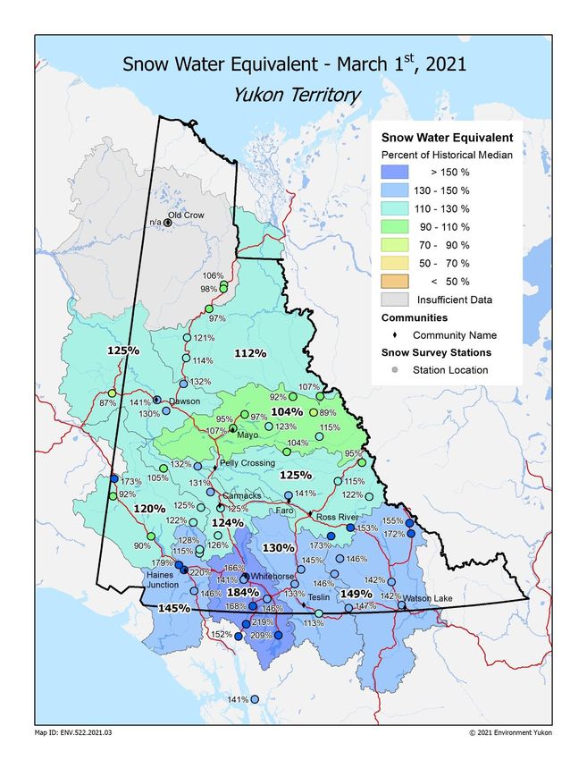
PREFACE
The Department of Environment’s Water Resources Branch issues the Yukon Snow Survey Bulletin and Water Supply
Forecast three times annually – early March, April and May. The bulletin provides a summary of winter meteorological
and streamflow conditions for Yukon, as well as current snow depth and snow water equivalent observations for 57
locations. This information is used to evaluate the potential for spring flooding caused by both breakup ice jams and large
spring snowmelt (freshet) flows. It is important to note that other processes such as summer rain and glacier melt can
significantly influence maximum annual water levels in specific Yukon basins.
The Snow Bulletin is continuing to improve using new technologies and comments provided by users and partners. The
fall and winter average weather conditions (temperatures and precipitation) are spatially presented for the entire territory
in two figures showing October 1 to February 28 anomalies. The spatial distribution of Snow Water Content (or Snow
Water Equivalent, SWE) is presented for 11 watersheds (or river basins) in a separate figure. Complementary
meteorological and hydrological data are presented for each basin through a series of five graphs, depending on data
availability:
Figure A: Daily Snow Water Equivalent (SWE) data starting in September at one specific location in the
watershed, showing an overview of winter snowpack evolution.
Figure B: Current, basin-averaged, estimated Snow Water Equivalent (SWE) from snow survey data, compared
with historical data, serving as an indicator of potential runoff volumes in the spring (acknowledging that snow
sublimation, evapotranspiration, rain and glacier melt also significantly affect runoff).
Figure C: Monthly-averaged winter precipitation (rain and/or snow) compared with historical data (1980-2020
period of record), complementing the information presented in Figure B.
Figure D: Cumulated degree-days of freezing (CDDF, sum of negative daily temperatures) compared with
historical data, functioning as an indicator of winter coldness and overall river ice thickness; variables that influence
river ice breakup scenarios in the spring.
Figure E: Current, estimated daily discharge or measured water level, compared with historical data, representing
an overview of the watershed hydrological conditions.
Information about the bulletin, snowpack conditions, or streamflow projections can be obtained by contacting:
Jonathan Kolot Alexandre Mischler Anthony Bier Holly Goulding
Hydrology Technologist Hydrology Technologist Intermediate Hydrologist Senior Hydrologist
(867) 667-3234 (867) 667-3144 (867) 667-5029 (867) 667-3223
jonathan.kolot@yukon.ca alexandre.mischler@yukon.ca anthony.bier@yukon.ca holly.goulding@yukon.ca
Water Resources Branch, Department of Environment
(867) 667-3171, toll free (in Yukon, NWT, Nunavut): 1-800-661-0408, ext. 3171
Fax: 867-667-3195 | Email: water.resources@yukon.ca
This bulletin, as well as earlier editions, are available online at:
https://yukon.ca/snow-surveys-and-water-supply-forecasts#snow-and-water-supply-data
ISSN 1705-883X
Reference to this report should be made in the following form:
Yukon Snow Survey Bulletin and Water Supply Forecast, March 1, 2021
© March 2021
Water Resources Branch
Department of Environment
Government of Yukon
Box 2703, Whitehorse, Yukon Y1A 2C6
Yukon Snow Survey Bulletin and Water Supply Forecast March 1, 2021 2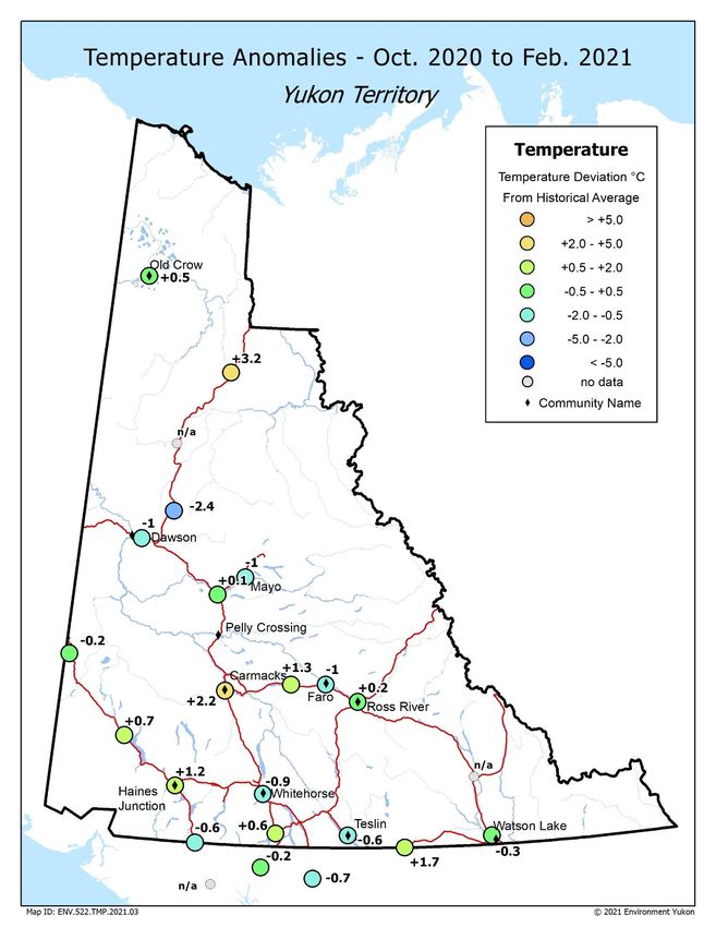
ACKNOWLEDGMENTS The Yukon Snow Survey Bulletin forms part of the Yukon Snow Survey Program administered by the Water Resources Branch, Department of Environment, Government of Yukon. Other agencies that contribute significantly to the Snow Survey Program by providing data, assistance and information for the bulletin are: Data Collection Officer, Natural Resources Conservation Service, United States Department of Agriculture Meteorologist, Wildland Fire Management, Yukon Department of Community Services, Whitehorse Officer in Charge, Water Survey of Canada, Whitehorse Water Management Engineer, Yukon Energy Corporation McMaster University Agencies cooperating with Environment Yukon in the Snow Survey Program are: B.C. Ministry of Environment, Water Stewardship Division Parks Canada, Kluane National Park and Reserve Yukon Department of Highways and Public Works Yukon Department of Energy Mines and Resources, Compliance Monitoring and Inspections Branch Yukon Department of Environment, Information Management and Technology Branch Vuntut Gwitchin First Nation DISCLAIMER AND LIMITATION OF LIABILITY The User understands and acknowledges that the use of the data is solely at their own risk. The User is solely responsible for confirming the accuracy, availability, suitability, reliability, usability, completeness or timeliness of the data. The User accepts the data “as is” and acknowledges that the Government of Yukon makes no warranties or representations (express or implied) with respect to the accuracy, availability, suitability, reliability, usability, completeness or timeliness of the data, including, without limitation, implied warranties for merchantability, fitness for a particular purpose, and non-infringement. In consideration of access to the data, the User also agrees that in no event will the Government of Yukon be liable (in tort or contract) or responsible whatsoever to the User or any other legal entity for the accuracy, availability, suitability, reliability, usability, completeness or timeliness of the data, including, without limitation, any loss of revenue or profit, or for direct, indirect, special, incidental, or consequential damages arising from or related to the data. Yukon Snow Survey Bulletin and Water Supply Forecast March 1, 2021 3
YUKON TERRITORY WEATHER AND SNOWPACK CONDITIONS
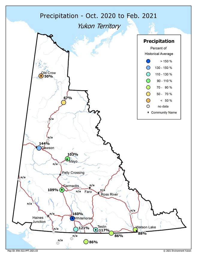
Fall and winter 2020-21 temperatures varied greatly from month to month. Generally, the months of October,
November and February were colder than the historical average1 in most regions of the territory while
December and January were warmer than the historical average. Precipitation anomalies were substantial in
November, December and February, with some regional contrasts between the much wetter conditions in the
south and a drier winter in the far north. Heavy snowfall in November set the stage for above normal
snowpack conditions observed in the majority of the territory.
October
October was drier than normal in southeastern, southwestern and northern Yukon while the Carmacks region
received more precipitation than normal. Temperatures were two to three degrees colder than normal for
central and southern Yukon and slightly warmer than normal in Old Crow.
November
The beginning of the month saw significant precipitation in southern and central Yukon with likely record-
breaking snowfall in Whitehorse on November 2 (also high snowfall in Carcross, Atlin, Teslin, Dawson, Mayo
& Watson Lake). Monthly average temperatures were two to four degrees colder than normal for much of the
territory. By contrast, there was lower than average precipitation and close to normal temperatures in the far
north (Old Crow, Eagle Plains) and the northern Kluane region (Beaver Creek and Burwash Landing).
December
December began with the incursion of an atmospheric river in southwestern Yukon; following substantial
snowfall on December 1, unseasonably warm weather and rain resulted in significant snowmelt. Whitehorse
and Carcross reported more than twice the normal amount of precipitation for December and a winter storm
on December 14 brought closures to both the Haines and White Passes. By contrast, northern regions were
drier than normal in December. Temperatures were substantially warmer than normal across all of south and
central Yukon from Watson Lake to Beaver Creek to Stewart Crossing. Northern regions experienced slightly
above normal temperatures.
January
Most areas of Yukon received less precipitation than normal in January. Only Carcross and Haines Junction
stations reported more precipitation than normal. A January 18 winter storm closed both the Haines and
White Passes as well as the Alaska Highway on January 19. January saw a continuation of the much warmer
than normal weather throughout Yukon, with temperatures ranging from four to seven degrees above normal.
February
Precipitation varied throughout Yukon in February, with some areas in south and central Yukon reporting
between 130% and 290% of normal. February 21-22 brought an atmospheric river that resulted in a multi-
day closure of the White and Haines Passes. Dawson was also much wetter with 278% of normal
precipitation, whereas far north regions were drier than normal. February was, overall, colder than normal
with stations reporting temperatures ranging from four to eight degrees below normal.
1
Historical temperature, precipitation, snow water equivalent and discharge or water level records are not always long
enough to establish a state-of-the-art “normal”, which implies 30 years of data. Therefore, this document refers to
historical average, or more simply, average. Historical records considered in this bulletin are always long enough to be
representative of recent hydro-meteorological conditions.
Yukon Snow Survey Bulletin and Water Supply Forecast March 1, 2021 4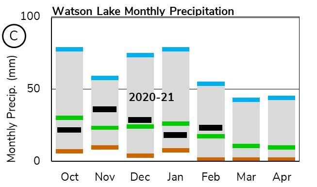
MAP 1. TEMPERATURE ANOMALIES

 Yukon Snow Survey Bulletin and Water Supply Forecast March 1, 2021   5
MAP 2. PRECIPITATION

 Yukon Snow Survey Bulletin and Water Supply Forecast March 1, 2021   6
MAP 3. SNOW WATER EQUIVALENT

 Yukon Snow Survey Bulletin and Water Supply Forecast March 1, 2021   7
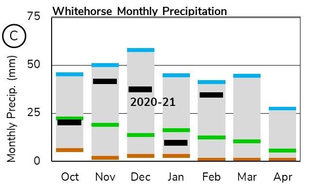
UPPER YUKON RIVER BASIN (SOUTHERN LAKES / WHITEHORSE)
At Wolf Creek Subalpine Station, Snow Water Equivalent (SWE) is estimated to be 194% of the historical
average (Figure A1), while at Tagish Station, SWE is estimated to be 153% of the historical average (Figure
A2). The Upper Yukon basin-averaged SWE is estimated to be 184% of the historical median, with 308 mm
on March 1 (Figure B). This is the highest recorded snowpack on record for this time of year.

Monthly precipitation at Whitehorse Airport during fall and winter was, at times, well above average and at
others, below average (Figure C) with the total precipitation being well above average on March 1.
Cumulated degree-days of freezing (CDDF) are close to average, with 1600 oC-Days (Figure D), which
suggests that the thickness of the ice cover on rivers and lakes of the region is likely close to normal.

  Yukon Snow Survey Bulletin and Water Supply Forecast March 1, 2021                                      8
The measured water surface elevation (relative to sea level) in Marsh Lake is currently above average (Figure
E). Water levels in the Southern Lakes are driven by a combination of snowmelt, summer precipitation and
glacier melt. Current snow conditions suggest that water levels will be higher than average this summer.
Weather conditions over the spring and summer will determine the peak water level in Marsh Lake.

  Yukon Snow Survey Bulletin and Water Supply Forecast March 1, 2021                                      9

TESLIN RIVER BASIN
The Teslin River basin-averaged SWE is estimated at 130% of the historical median, with 215 mm on
March 1 (Figure B).

Teslin monthly precipitation was similar to that of other southern communities with some months being above
average and other months below (Figure C), with total precipitation being above average on March 1.

The measured water surface elevation (relative to sea level) in Teslin Lake is currently close to average
(Figure E). The higher than median snowpack and the close to average water level suggest that summer
water levels could be higher than average. Weather conditions in March and April will determine the most
probable spring scenario.

 Yukon Snow Survey Bulletin and Water Supply Forecast March 1, 2021                                     10
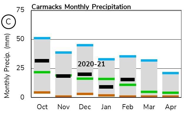
CENTRAL YUKON RIVER BASIN (CARMACKS AREA)
The Central Yukon basin-averaged SWE is estimated to be 124% of the historical median, with 107 mm on
March 1 (Figure B).

Carmacks monthly precipitation has varied; at times above average and at others, below average (Figure C),
with total precipitation being just above average on March 1.

Water levels in Carmacks area rivers could be higher than average this spring and summer. Weather
conditions in March and April will determine the most probable spring scenario.

 Yukon Snow Survey Bulletin and Water Supply Forecast March 1, 2021                                    11
PELLY RIVER BASIN
At Twin Creeks weather station, Snow Water Equivalent (SWE) is estimated to be 99% of the historical
average (Figure A). The Pelly River basin-averaged SWE is estimated to be 125% of the historical median,
with 158 mm as of March 1 (Figure B).

Precipitation at Faro has not been recorded, but snowpack observations indicate values are above average.
Cumulated degree-days of freezing (CDDF) at Faro are close to average at 2270 oC-Days (Figure D), which
suggests that the thickness of the ice cover on rivers and lakes of the region is likely close to normal.

The estimated Pelly River discharge at Pelly Crossing is currently above average (Figure E). The higher than
normal snowpack in the watershed increases the probability of significant spring freshet flows. Weather
conditions in March and April will determine the most probable spring scenario.

 Yukon Snow Survey Bulletin and Water Supply Forecast March 1, 2021                                      12
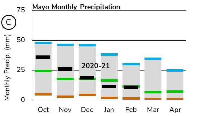
STEWART RIVER BASIN
At Withers Lake Meteorological station, Snow Water Equivalent (SWE) is estimated to be 95% of the
historical average (Figure A). The Stewart River basin-averaged SWE is estimated to be 104% of historical
median, with 158 mm as of March 1 (Figure B). This is considered a normal snowpack for the area.

Precipitation at Mayo Airport has varied this winter, with the total amount being average on March 1 (Figure
C). Cumulated degree-days of freezing (CDDF) are close to average, with 2550 oC-Days (Figure D), which
suggests that the thickness of the ice cover on rivers and lakes of the region is likely close to normal.

The estimated Stewart River discharge at the outlet is currently near historically high winter flows (Figure E).
The near median snowpack suggests close to average peak flows. Weather conditions in March and April
will determine the most probable spring scenario.

 Yukon Snow Survey Bulletin and Water Supply Forecast March 1, 2021                                        13
WHITE RIVER BASIN
The White River basin-averaged SWE is estimated to be 120% of the historical median, with 98 mm as of
March 1 (Figure B). This, however, is probably more representative of the foothills of the St. Elias Range, while
the relative SWE (%) in the range itself could be higher.

The estimated White River discharge at the Alaska Highway is currently well above average at historically
high winter levels (Figure E). In this watershed, high flows are dominated by mountain snowmelt and glacial
melt that are largely influenced by summer temperatures and precipitation. The current above median
snowpack suggests higher than average freshet volumes are possible. Weather conditions over the spring
and summer will determine peak flows.

 Yukon Snow Survey Bulletin and Water Supply Forecast March 1, 2021                                         14
LOWER YUKON RIVER BASIN (DAWSON AREA)
The Lower Yukon basin-averaged SWE is estimated to be 125% of the historical median, with 172 mm as of
March 1 (Figure B).

Monthly precipitation at Dawson Airport (Figure C) alternated between close to normal values and record high
precipitation in November 2020 and February 2021. Cumulated degree-days of freezing (CDDF) are slightly
above average, with 2990 oC-Days (Figure D), which suggests that the thickness of the ice cover on rivers
and lakes of the region is likely close to normal.

The estimated Yukon River discharge at the White River is well above average (Figure E). The above median
snowpack in all upstream basins suggests a high potential for significant spring freshet flows. These
statements also apply to the Klondike River. Weather conditions in March and April will determine the most
probable spring scenario.

 Yukon Snow Survey Bulletin and Water Supply Forecast March 1, 2021                                    15
LIARD RIVER BASIN
At Hyland meteorological station, Snow Water Equivalent (SWE) is estimated to be 151% of the historical
average (Figure A). The Liard River basin-averaged SWE is estimated to be 149% of the historical median,
with 235 mm as of March 1 (Figure B). This is considered a significant snowpack for the area.

Precipitation at Watson Lake Airport has been variable in the last six months (Figure C). The cumulative result
is below average, but this only applies to the southern portion of the Liard watershed.

The estimated Liard River discharge at Upper Liard is currently slightly above average (Figure E). The well
above median snowpack in the watershed suggests a high potential for significant spring freshet flows.
Weather conditions in March and April will determine the most probable spring scenario.

 Yukon Snow Survey Bulletin and Water Supply Forecast March 1, 2021                                       16
ALSEK RIVER BASIN
The Alsek River basin-averaged SWE is estimated to be 145% of the historical median, with 181 mm as of
March 1 (Figure B). This, however, may only be representative of the Kluane and Aishihik Lake areas while the
snowpack in the St. Elias Range may be higher. This is considered a significant snowpack for the area.

The estimated Alsek River discharge is currently near historically high levels (Figure E). High flows in this
watershed are dominated by mountain snowmelt and glacial melt that are largely influenced by summer
temperatures and precipitation. The snowpack in the St. Elias Range is likely to generate significantly higher
than average freshet volumes. Weather conditions over the spring and summer will determine peak flows.

 Yukon Snow Survey Bulletin and Water Supply Forecast March 1, 2021                                        17
PEEL RIVER BASIN
The Peel River basin-averaged SWE is estimated to be 112% of the historical median, with 129 mm on
March 1 (Figure B). This is considered a normal snowpack for this time of year.

The estimated Peel River discharge is historically high (Figure E). The near median snowpack suggests close
to average peak flows. Weather conditions in March and April will determine the most probable spring
scenario.

 Yukon Snow Survey Bulletin and Water Supply Forecast March 1, 2021                                    18
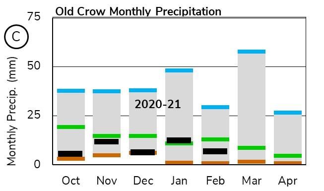
PORCUPINE RIVER BASIN
The Old Crow snow course was not sampled for March 1, 2021. Snow courses on the eastern edge of the
Porcupine basin were near normal; however, precipitation at Old Crow shows overall below average monthly
values during fall and winter (Figure C). Cumulated degree-days of freezing (CDDF) are close to average,
with 3315 oC-Days as of March 1 (Figure D), which suggests a normal ice cover thickness on lakes and rivers
in the region.

The estimated Porcupine River discharge is historically high (Figure E). With limited snowpack data it is
difficult to predict potential spring flow volumes. However, given the available data, peak flows are likely to be
close to average. Weather conditions in March and April will determine the most probable spring scenario.

 Yukon Snow Survey Bulletin and Water Supply Forecast March 1, 2021                                          19
DRAINAGE BASIN AND SNOW COURSE
For Sample Date: 2021-03-01

                                                                      This
                                                                                Water                  Median
                                          Eleva-                      year                  Last                    Years
                                                      Date of                  content                Historical
        Name                Number         tion                      snow                   year                     of
                                                      survey                   (SWE)                    SWE
                                           (m)                       depth                 (mm)                    record
                                                                                (mm)                    (mm)
                                                                      (cm)
Alsek River Basin
Canyon Lake             08AA-SC01         1160     2021-02-24       53         92        70           80           43
Alder Creek             08AA-SC02         768      2021-02-24       92         194       131          144          40
Aishihik Lake           08AA-SC03         945      2021-02-24       50         88        69           72           27
Haines Junction Farm    08AA-SC04         610      2021-03-01       79         174       78           85           21
Summit                  08AB-SC03         1000     2021-03-01       139        411       203          233          41
Yukon River Basin
Tagish                  09AA-SC01         1080     2021-02-25       85         184       143          127          45
Montana Mountain        09AA-SC02         1020     2021-02-24       92         220       140          130          45
Log Cabin (B.C.)        09AA-SC03         884      2021-02-23       216        700       405          329          59
Atlin (B.C)             09AA-SC04         730      2021-03-01       90         207       54           107          55
Mt McIntyre B           09AB-SC01B        1097     2021-02-25       88         189       157          135          45
Whitehorse Airport      09AB-SC02         700      2021-02-25       74         151       105          91           56
Meadow Creek            09AD-SC01         1235     2021-03-01       139        322       277          244          44
Jordan Lake             09AD-SC02         930      2021-02-24       85         172       N.S.         125          30
Morley Lake             09AE-SC01         824      2021-03-01       77         141       123          138          32
Mount Berdoe            09AH-SC01         1035     2021-02-26       70         119       124          97           45
Satasha Lake            09AH-SC03         1106     2021-02-26       60         101       89           83           33
Williams Creek          09AH-SC04         914      2021-02-26       63         104       110          87           24
Twin Creeks B           09BA-SC02B        900      2021-02-24       74         146       181          132          4
Hoole River             09BA-SC03         1036     2021-02-24       95         201       203          122          42
Burns Lake              09BA-SC04         1112     2021-02-24       106        236       248          198          32
Finlayson Airstrip      09BA-SC05         988      2021-02-24       68         136       146          94           34
Fuller Lake             09BB-SC03         1126     2021-02-23       88         162       171          169          31
Russell Lake            09BB-SC04         1060     2021-02-23       97         201       196          200          33
Rose Creek              09BC-SC01         1080     2021-02-25       66         134       121          98           26
Mount Nansen            09CA-SC01         1021     2021-02-26       53         84        79           68           44
MacIntosh               09CA-SC02         1160     2021-02-26       61         94        94           81           44
Burwash Airstrip        09CA-SC03         810      2021-02-24       26         36        49           40           44
Beaver Creek            09CB-SC01         655      2021-02-24       55         109       70           73           45
Chair Mountain          09CB-SC02         1067     2021-02-24       50         71        99           85           27
Casino Creek            09CD-SC01         1065     2021-02-26       73         112       128          108          42
Pelly Farm              09CD-SC03         472      2021-03-01       61         100       127          76           34
Plata Airstrip          09DA-SC01         830      2021-02-23       93         185       191          168          39
Withers Lake            09DB-SC01         975      2021-02-23       91         167       253          198          33
Rackla Lake             09DB-SC02         1040     2021-02-23       79         147       218          164          30

Code "E" - Estimate, Code "B" - Survey date is outside of valid sampling range, “N.S.” – No survey.

  Yukon Snow Survey Bulletin and Water Supply Forecast March 1, 2021                                                    20
DRAINAGE BASIN AND SNOW COURSE
For Sample Date: 2021-03-01
This
Water Median
Eleva- year Last Years
content Historic
Name Number tion Date of survey snow year of
(SWE) al SWE
(m) depth (mm) record
(mm) (mm)
(cm)
Yukon River Basin
Mayo Airport A 09DC-SC01A 540 2021-02-25 58 98 154 91 50
Mayo Airport B 09DC-SC01B 540 2021-02-25 59 90 150 94 31
Edwards Lake 09DC-SC02 830 2021-02-23 89 167 N.S. 142 31
Calumet 09DD-SC01 1310 2021-02-24 84 167 277 174 43
King Solomon 09EA-SC01 1070 2021-02-25 85 190 189 148 46
Dome
Grizzly Creek 09EA-SC02 975 2021-02-23 84 193 263 155 45
Midnight Dome 09EB-SC01 855 2021-02-25 86 190 218 135 45
Boundary (Alaska) 09EC-SC02 1005 2021-02-28 64 99 198 117 42
Porcupine River Basin
Riff's Ridge 09FA-SC01 650 2021-02-23 69 128 155 130 34
Eagle Plains 09FB-SC01 710 2021-02-23 70 141 115 150 38
Eagle River 09FB-SC02 340 2021-02-23 66 113 E 97 114 37
Old Crow 09FD-SC01 299 N.S. N.S. 106 27
Liard River Basin
Watson Lake 10AA-SC01 685 2021-02-24 75 168 135 131 56
Airport
Tintina Airstrip 10AA-SC02 1067 2021-02-24 116 265 274 188 40
Pine Lake Airstrip 10AA-SC03 995 2021-03-01 131 275 229 199 44
Ford Lake 10AA-SC04 1110 2021-02-24 108 236 279 173 31
Frances River 10AB-SC01 730 2021-02-24 88 192 206 142 45
Hyland River 10AD-SC01 855 2021-02-23 106 265 263 156 45
Hyland River B 10AD-SC01B 880 2021-02-23 112 276 275 197 3
Peel River Basin
Blackstone River 10MA-SC01 920 2021-02-23 57 96 111 87 45
Ogilvie River 10MA-SC02 595 2021-02-23 63 108 144 93 45
Bonnet Plume Lake 10MB-SC01 1120 2021-02-23 72 153 203 150 30
Alaska Snow Courses
Eaglecrest 08AK-SC01 305 2021-03-04 198 551 643 419 38
Moore Creek 08AK-SC02 700 2021-02-26 216 691 518 454 28
Bridge
Code "E" - Estimate, Code "B" - Survey date is outside of valid sampling range, “N.S.” – No survey.
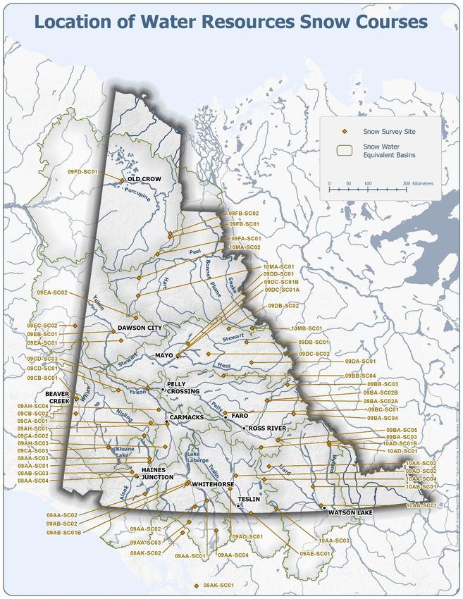
Yukon Snow Survey Bulletin and Water Supply Forecast March 1, 2021 21MAP 4. LOCATION OF WATER RESOURCES SNOW COURSES Yukon Snow Survey Bulletin and Water Supply Forecast March 1, 2021 22
You can also read