Integrating Remotely Sensed Observations of Surface Water Storage with Climate Forecast for Freshwater Management - Report of Senior Researcher ...
←
→
Page content transcription
If your browser does not render page correctly, please read the page content below
The India-UK Water Centre (2020)

Integrating Remotely Sensed
Observations of Surface Water Storage
with Climate Forecast for Freshwater
Management
Report of Senior Researcher Exchange April-May
2018
March 2020

                                                              1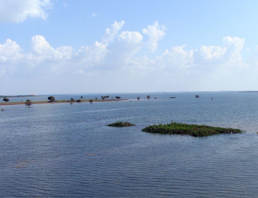
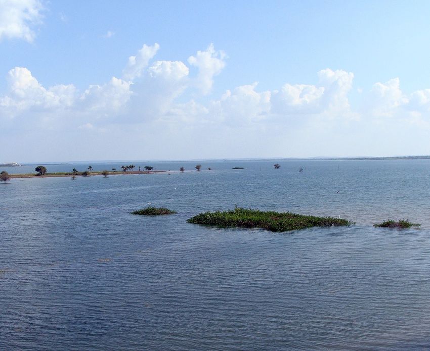
Report of Senior Researcher Exchange

Integrating Remotely Sensed Observations of Surface Water
Storage with Climate Forecast for Freshwater Management
Report of Senior Researcher Exchange April-May 2018
Published March 2020

India-UK Water Centre
www.iukwc.org

UK Coordination Office                           Indian Coordination Office
UK Centre for Ecology & Hydrology                Indian Institute of Tropical Meteorology
Benson Lane                                      Dr. Homi Bhabha Road
Crowmarsh Gifford, Wallingford                   Pune-411008,
OX10 8BB                                         Maharashtra
UK                                               India

CITATION
Mishra, V. & Sembhi, H. (2020). Integrating remotely sensed observations of surface water storage
with climate forecast for freshwater management. Report of Senior Research Exchange March
2020. The India-UK Water Centre. UK Centre for Ecology & Hydrology, Wallingford and Indian
Institute of Tropical Meteorology, Pune.
Version 2.0 20/09/19

The India-UK Water Centre promotes cooperation and collaboration between the complementary
priorities of NERC-MoES water security research.

भारत-ब्रिटेन जल कें द्र एमओईएस-एनईसीआरसी (यूके ) जल सुरक्षा अनुसंधान के पूरक प्राथमिकताओ के बीच
सहयोग और सहयोग को बढ़ावा देने के लिए करना है

Front cover image: Krishna River (Pixabay)
The India-UK Water Centre (2020)

Contents
Executive Summary 								ii
1.   Activity Leads 								1
2.   Exchange Aims								2
3.   Exchange Structure and Research 				                                  2
     3.1.   Data sources and research design				                           2
4.   Data Analysis and Outputs					5
     4.1.   Performance of remotely sensed reservoir storage		             5
     4.2.   Image processing							8
     4.3.   Estimating reservoir storage of Ghat Prabha			                 9
5.   Conclusions 								9
6.   Annexes									10

                                                                                  i
Report of Senior Researcher Exchange

Executive Summary
This report presents an overview of research exchange undertaken by Dr Vimal Mishra (IIT,
Gandhinagar) at Dr Harjinder Sembhi’s lab at University of Leicester, UK. The exchange focussed
largely on developing a methodology to estimate freshwater storage of lakes in India using the
Multi Spectral Instrument (MSI) on European Space Agency’s Sentinel 2 mission.
Remote sensing has successfully provided the solutions for monitoring water storage in large
water bodies, however monitoring changes in storage in smaller water bodies (less than
100,000 m2) remains a challenge. This is mainly because of the coarser resolution achieved by
many space-borne sensors. Tracking of storage changes in smaller water bodies can help to
understand the risks of water availability, particularly in vulnerable regions, and provide critical
information for stakeholders in decision making for freshwater management. This exchange
visit aimed to develop a remote sensing based framework to monitor changes in water storage
during the dry season in India in a selection of diverse climatic regions located in semi-arid areas
of Gujarat and West Bengal. The exchange aimed to utilise long-term climate data records of
land surface temperature, developed at the University of Leicester, as well as, novel high-spatial
resolution observations from the Sentinel 2 mission.

ii
The India-UK Water Centre (2020)

1. Activity Leads
The Junior Research Exchange was convened by the India-UK
Water Centre (IUKWC) and involved Activity Leads:
Dr Vimal Mishra
Senior Research Exchange Lead
Dep of Civil Engineering,
Indian Institute of Technology
Gandhinagar - 382355, India
vmishra@iitgn.ac.in

Dr Harjinder Sembhi
Research Exchange Host
Department of Physics and Astronomy University of Leicester
Leicester, LE1 7RH, UK
hs32@le.ac.uk

The exchange was held at the Earth Observation Science Group, Department of Physics and
Astronomy, University of Leicester, UK from 19th June to 29th June 2018

                                                                                              1
Report of Senior Researcher Exchange

2. Exchange Aims
The India-UK Water Centre is based around five key cross-sectoral themes and aims to deliver
a portfolio of activities across these themes.
This Senior Research Exchange focused on the themes:
    •   Using new scientific knowledge to help stakeholders set objectives for freshwater
        management; and
    •   Improving freshwater monitoring frameworks and data for research and management.
The Exchange focussed largely on developing a methodology to estimate freshwater storage of
lakes in India using the Multi Spectral Instrument (MSI) on European Space Agency’s Sentinel 2
mission. The specific objectives of the exchange were:
    •   To develop a remote sensing based framework to monitor changes in water storage
        during the dry season in India (science objective);
    •   Use of Earth Observation to map variation in surface water extent and to utilise the outputs
        to determine water storage (volume) using depth-area relationship (science objective);
        and
    •   To transfer knowledge and information about Earth Observation and in situ datasets
        and co-develop methodology for surface monitoring applications (knowledge exchange
        objective).

3. Exchange Structure and
Research
The exchange visit took place from Tuesday 19th June to Friday 29th June 2018 with the Earth
Observation Science Group based at the Department of Physics and Astronomy, University of
Leicester, UK. During this period, the lead, Dr Vimal Mishra, delivered a research seminar on
drought monitoring to the Earth Observation Science and Centre for Climate and Landscape
Research Groups. The visit also consisted of regular networking and knowledge exchange
meetings with colleagues from the University of Leicester, as well as, Kings College London and
Imperial College London.

3.1. Data sources and research design
Earth observation satellites
The investigation focussed on utilising high-resolution observations made by the Multi-Spectral
Imager (MSI) through the European Space Agency (ESA) Sentinel 2 mission. The mission
was developed as part of the European Copernicus program for the purpose of supporting
operational services related to monitoring changes in land cover and managing natural disasters;
two satellites were launched in June 2015 and March 2017 under this mission (Table 1).

2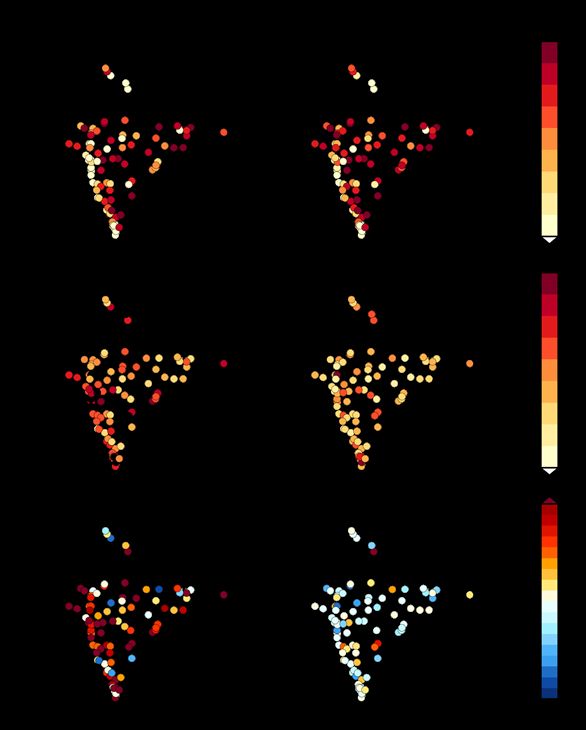
The India-UK Water Centre (2020)

Table 1: Sentinel 2 bands along with its central wavelength, resolution and bandwidth
 Sentinel-2 Bands                   Central                 Resolution (m)         Bandwidth (nm)
                                    Wavelength (µm)
 Band 1 – Coastal aerosol           0.443                   60                     27/45 (2A/2B)
 Band 2 – Blue                      0.490                   10                     98
 Band 3 – Green                     0.560                   10                     45/46 (2A/2B)
 Band 4 – Red                       0.665                   10                     38/39 (2A/2B)
 Band 5 – Vegetation Red Edge 0.705                         20                     19/20 (2A/2B)
 Band 6 – Vegetation Red Edge 0.740                         20                     18
 Band 7 – Vegetation Red Edge 0.783                         20                     28
 Band 8 – NIR                       0.842                   10                     115
 Band 8A – Narrow NIR               0.865                   20                     20
 Band 9 – Water vapour              0.945                   60                     20
 Band 10 – SWIR – Cirrus            1.375                   60                     20
 Band 11 – SWIR                     1.610                   20                     90
 Band 12 – SWIR                     2.190                   20                     180
Data Source: https://www.sentinel-hub.com/develop/documentation/eo_products/Sentinel2EOproducts

Case study
Ghataprabha River is a tributary of River Krishna and is one of the major sources of water supply
to Belgaum city and adjoining areas in Karnataka (Purandara et al. 2011). The Ghataprabha/
Hidkul Lake has a surface area of 73.0233 km2 and is a result of the construction of dams
under the Ghata Prabha irrigation project in 1897. The lake is located at 74.64°E, 16.148°N and
stretches across Karnataka and Maharashtra states (Karnataka Water Resources Department
accessed online).

Data sourcing and research design
Eight-day composite MODIS EVI images obtained from Tiwari & Mishra (2018) were used
to create a mask for a reservoir considering pixels with EVI less than 0.1 as ‘water pixel’. To
estimate the surface area of a reservoir covered with water on a particular day, the number of
pixels (classified as water) were multiplied by the area of a single pixel (250x250 m2). However,
this approach to estimate the reservoir’s surface area has errors and inconsistencies as reported
in the previous studies (Gao et al., 2012; Zhang et al., 2014). To overcome this, a nonparametric
unsupervised K-means clustering approach was adopted. In this approach the masked area was
further classified into three classes: water, non-water dry surface, and non-water wet surface as
described in Zhang et al. (2014). The enhanced image classification technique was also used to
improve the classification of water surface area as described in Zhang et al. (2014).
The reservoir surface elevation data was extracted from ICESat/GLAS dataset obtained from
National Snow and Ice Data Center (NSIDC: https://nsidc.org/data/icesat/data.html). The
datasets are available from January 2003 to February 2010 (Shuman et al., 2006; Wang et al.,
2013; Zhang et al., 2011). The vertical precision of the ICESat/GLAS data is higher than 10 cm
(Zwally et al., 2008) with a horizontal spacing of 172 m (Kwok et al., 2004). Further, the ICESat/
GLA14 Release-34 elevation data was also obtained from the National Snow and Ice Data Center.
Using water surface area and water surface elevation, a linear surface area-elevation relationship
was assumed to be as per equation 1.
					                                       E=a ×A+b                                            (1)

                                                                                                          3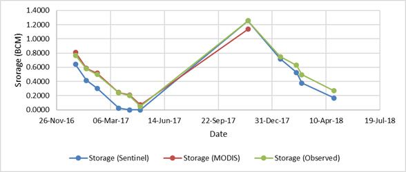
Report of Senior Researcher Exchange

Where E is the water surface elevation from mean sea level, A is the reservoir surface area, and
a and b are constants; obtained from the best fit relationship between water surface area and
water surface elevation.
Due to the limited availability of ICESat/GLAS elevation, reservoir storage from the ICESat/
GLAS and MODIS data cannot be obtained directly. Using elevation data from area-elevation
relationship, reservoir storage was estimated using equation 2, and as mentioned in Gao et al.
(2012) and Zhang et al. (2014).
			                         V_RS=V_C-(h_C-h_RS )(A_C+A_RS )⁄2                                 (2)

Where Vc, hc, and Ac represent storage, area, and water elevation at capacity (maximum
storage), and VRS, HRS and ARS are the estimated storage, area, and water elevation using
remote sensing.
The observed storage, area, and water elevation at capacity for each reservoir were obtained
from Water Resources Information System of India (http://tamcnhp.com/wris/#/).

General methodology
        •   Sentinel 2 multi-spectral images were selected from June 2016 to June 2018 using the
            Copernicus browsing platform (https://www.sentinel-hub.com/)
        •   Sentinel 2A tiles were selected over GhatPrabha/Hidkul Lake, which was selected as a
            test case from the lake database generated by IIT Gandhinagar (Table 2).
        •   Individual scenes were traced through to extract clear-sky scenes; these were used to
            calculate the Normalised Differential Vegetation Index (NDVI1) using an ESA Sentinel
            Application Platform (SNAP). This toolbox allows EO processing and analysis directly on
            raw satellite imagery or channel data.
Table 2: Location and characteristics of some small reservoirs in India
    S. No.    Dam                  x           y            Full      Storage       Area
                                                            reservoir (BCM) at      (km2)
                                                            level (m) Capacity
    18        GhatPrabha/Hidkul 74.642         16.148       662.95        1.391     73.0233
    72        Sholayar             76.744      10.309       1002.79       0.143     5.723
    17        Gerusoppa            74.6749 14.25164 55                    0.13      5.98
    1         Aliyar               76.981      10.488       320.04        0.095     6.5
    9         Bhandardara          73.767      19.534       744.91        0.304     7.4318
    30        Jhakham              74.032      23.982       359.5         0.132     10.148
    37        Khadakwasla          73.7681 18.4417          582.47        0.056     14.8
    33        Kakki                77.15       9.326        981.46        0.447     17.51
    50        Manikdoh             73.816      19.239       711.25        0.288     18.434
    22        Harangi              75.9056 12.4917          871.42        0.22      19.08096

1
 The Normalized Difference Vegetation Index (NDVI) is a numerical indicator that uses the visible
and near-infrared bands of the electromagnetic spectrum, and is adopted to analyze remote
sensing measurements and assess whether the target being observed contains live green
vegetation or not.
Pettorelli, N., 2013. The normalized difference vegetation index. Oxford University Press.

4
The India-UK Water Centre (2020)
4. Data Analysis and Outputs
4.1. Performance of remotely sensed reservoir storage
Comparison of 8-day composite satellite-based reservoir storage and 8-day mean observed
storage for 9 selected reservoirs (Almatti, Bargi, Bhadra, Hirakud, Lower Manair, Malaprabha,
Figure 1: Comparison of satellite storage using MODIS data and Observed
storage for selected 9 reservoirs
Rihand, Sabarmati, and Ukai) is presented. Comparison from the year 2002 to the year 2016 is
presented in Figure 1.
Performance of satellite-based 8-day reservoir storage was evaluated against the observed
storage using the coefficient of determination (R2), normalized root mean squared error
(NRMSE %) and bias (%). Median R2, NRMSE, and bias for remotely sensed reservoir storage
were 0.47, 50.90%, and 15.04%, respectively (Fig. 2). Here R2 is evaluated after removing
seasonality from the observed and satellite reservoir storage data. We find that the performance
of the remotely sensed reservoir storage was low in the western coastal region, which can be
attributed to complex topography and high cloud cover (Fig. 2).
5Report of Senior Researcher Exchange Figure 2: Skill between satellite reservoir storage and observed storage for 91 major reservoirs in India before and after bias correction. The same area elevation relationship was used for Ghat Prabha reservoir to evaluate the reservoir storage from December 2016 to April 2018 (Table 3 and Fig. 3). The storage obtained from Sentinel was compared with MODIS storage and observed storage as well. It was found that for the year 2017, storage obtained from MODIS data shows better result than storage obtained from Sentinel data for the Ghat Prabha reservoir (Fig. 6). 6
The India-UK Water Centre (2020)

Table 3: Comparison of Satellite storage using Sentinel and MODIS and Observed storage for Ghat
Prabha reservoir
 Date                Storage        Storage        Storage
                     (Sentinel)     (MODIS)        (Observed)
 31-Dec-16           0.6423         0.8110         0.77
 20-Jan-17           0.4166         0.5848         0.58
 09-Feb-17           0.3025         0.5160         0.50
 21-Mar-17           0.0235         0.2440         0.24
 10-Apr-17           0.0009         0.2099         0.20
 30-Apr-17           0.0000         0.0708         0.05
 16-Nov-17           1.2556         1.1360         1.25
 15-Jan-18           0.7188         -              0.75
 14-Feb-18           0.5261         -              0.63

Figure 3: Comparison of satellite storage using Sentinel and MODIS and observed storage for Ghat
Prabha reservoir

                                                                                                        7
Report of Senior Researcher Exchange
24-Feb-18 0.3782 - 0.50
25-Apr-18 0.1661 - 0.27
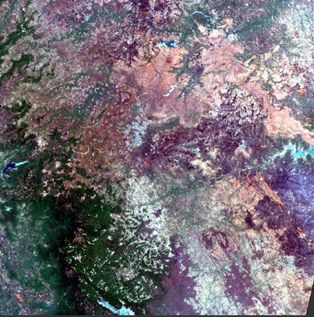
(a) 30th April 2017 (b) 16th November, 2017
Figure 4: Red-Green-Blue (RGB) image generated from S2A Level 1C tile covering GhatPrabha Lake on
(a) 30th April 2017 and (b) 16th November 2017
4.2. Image processing
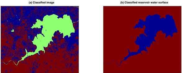
Sentinel 2 multi-spectral images were used (Fig. 4) to create a mask for Ghat Prabha reservoir
considering pixels with NDVI less than 0.1 as ‘water pixel’.
An approach similar to the calculation of surface water area from MODIS EVI was applied to
calculate the reservoir surface water area. The images were classified into three classes: water
(green), non-water dry surface (red), and non-water wet surface (blue) using K-means clustering
Figure 5: (a) Classified image in 3 classification parts as water (green), non-water dry surface (red),
and non-water wet surface (blue) and (b) classified Ghat Prabha reservoir water surface (blue) on 16th
November 2017
8The India-UK Water Centre (2020)
classification (Fig. 5a),. The classification was further enhanced using the MODIS EVI image
classification and enhancement approach. The number of pixels obtained in the classified area
(derived through above image processing) was multiplied with the area of 1 pixel (10mx10 m) to
determine the reservoir surface water area (Fig. 5b).
To validate the results for each reservoir, gauge observations were obtained from Water Resources
Information System of India (India-WRIS). This dataset has been available from January 01, 2002
for all reservoirs; the dataset exhibits daily repeat cycles (although with some missing dates) until
2016. Post-2016 the temporal resolution of this data has been 7 days, with 25 days of latency
period. The precision of this dataset for reservoir storage is 0.001 BCM.
4.3. Estimating reservoir storage of Ghat Prabha
The same area elevation relationship for Ghat Prabha reservoir was established to evaluate the
reservoir storage from December 2016 to April 2018 (Table 3 and Fig. 3).
5. Conclusions
For this study the storage data was derived from Sentinel and MODIS and compared with Gauge
observed dataset for validation. The key conclusion is that for the year 2017, storage obtained
from MODIS data shows better results than storage obtained from Sentinel data for the Ghat
Prabha reservoir.
9Report of Senior Researcher Exchange
6. Annexes
Annex A: References
Gao, H., Birkett, C., & Lettenmaier, D. P. (2012). Global monitoring of large reservoir storage
from satellite remote sensing. Water Resources Research, 48(9), 1–12. https://doi.
org/10.1029/2012WR012063
Karnataka Water Resources Department: http://waterresources.kar.nic.in/salient_features_
ghataprabha.htm
Kwok, R., Zwally, H. J., & Yi, D. (2004). ICESat observations of Arctic sea ice: A first look.
Geophysical Research Letters, 31(16), 1–5. https://doi.org/10.1029/2004GL020309
Purandara, Bekal & Narayanasamy, Varadarajan & Basappa, Venkatesh & Choubey, V.. (2011).
Surface water quality evaluation and modeling of Ghataprabha River, Karnataka, India.
Environmental monitoring and assessment. 184, 1371-8. DOI: 10.1007/s10661-011-2047-
1
Shuman, C. A., Zwally, H. J., Schutz, B. E., Brenner, A. C., DiMarzio, J. P., Suchdeo, V. P., & Fricker, H.
A. (2006). ICESat Antarctic elevation data: Preliminary precision and accuracy assessment.
Geophysical Research Letters, 33(7), 10–13. https://doi.org/10.1029/2005GL025227
Tiwari, A. D., & Mishra, V. (2018). Climate Change Impacts on Streamflow in India: Climate change
and water resources in India. In Ministry of Environment, Forest and Climate Change. pp
69–87.
Wang, X., Gong, P., Zhao, Y., Xu, Y., Cheng, X., Niu, Z., et al. (2013). Water-level changes in
China’s large lakes determined from ICESat/GLAS data. Remote Sensing of Environment,
132, 131–144. https://doi.org/10.1016/j.rse.2013.01.005
Zhang, G., Xie, H., Kang, S., Yi, D., & Ackley, S. F. (2011). Monitoring lake level changes on the
Tibetan Plateau using ICESat altimetry data (2003-2009). Remote Sensing of Environment,
115(7), 1733–1742. https://doi.org/10.1016/j.rse.2011.03.005
Zhang, S., Gao, H., & Naz, B. S. (2014). Monitoring reservoir storage in South Asia from multisatellite
remote sensing. Water Resource Research, 1–17. https://doi.org/10.1002/2014WR015829.
Received
Zwally, H. J., Yi, D., Kwok, R., & Zhao, Y. (2008). ICESat measurements of sea ice freeboard
and estimates of sea ice thickness in the Weddell Sea. Journal of Geophysical Research:
Oceans, 113(2), 1–17. https://doi.org/10.1029/2007JC004284
10The India-UK Water Centre (2020)
Back cover image: Krishna River (Pixabay)
11www.iukwc.org
You can also read