Camden.gov.uk/making-travel-safer-in-camden - We Are Camden
←
→
Page content transcription
If your browser does not render page correctly, please read the page content below
Consultation on New End
 Healthy School Street now
 open

 New End
 10th May 2021
 Information on our plans
 to create safer healthier
 streets in your area

camden.gov.uk/making-travel-safer-in-camden
New End Healthy School Street:
Consultation on proposing to make the trial
scheme permanent
Making your neighbourhood safer and healthier
The Covid-19 pandemic has changed how communities in Camden live, travel and work.
Many of us have been spending more time closer to home, making quieter and safer
neighbourhoods more important than ever. We want our streets to have more space for
everyone to walk and cycle, for you to be breathing cleaner air, for children to get to and
from school safely and for businesses to be able to flourish.

The Healthy School Streets scheme (HSS) is an initiative set up to reclaim the road space
in the vicinity of a school, providing children with the opportunity to travel to and from
school in a safer, less polluted environment, by closing the road to traffic at school opening
and closing times. HSS schemes meet a number of Camden’s Transport Strategy (CTS)
objectives which include improving local air quality and encouraging healthy lifestyles by
promoting walking, cycling or the use of public transport for school journeys. These
objectives were strongly supported when we consulted on them in developing the CTS.
You can read more about our strategy on our website:

camden.gov.uk/transport-strategies-and-plans

In response to the Covid-19 pandemic, a number of HSS
schemes have been rolled out across Camden since March
2020. There are currently a total of 18 schools that benefit from
them, including New End Primary School and Heathside
Preparatory School. The New End HSS scheme was
implemented in January 2020, just before the first Covid-19
lockdown, following an initial consultation in 2019.

About the New End Healthy School Street
The original consultation for a HSS scheme followed concerns raised by New End School
staff, and some local residents, regarding the safety of pupils due to the congested road
network in the area, insufficient pavement widths in some locations, and heavy parking
activity. There were also complaints made to both the school and the Transport Strategy
team from local residents regarding bad driver behaviour and parking issues on New End
near the schools, as well as reports of ‘rat-running’ traffic on New End and other nearby
streets.

                                                                                                 1
Following the consultation in February 2019, a decision was made to implement the New End
Healthy School Street (HSS) scheme as a trial, under an Experimental Traffic Order (ETO).
The decision report can be viewed on our website: camden.gov.uk/healthy-school-streets
This report noted that a further consultation, after around 12 months of the trial scheme,
would take place on any proposed permanent arrangements. The trial scheme went live in
January 2020. An ETO can only run for a total of 18 months.
Due to the Covid-19 pandemic and subsequent lockdowns, the HSS scheme at New End
did not operate between mid-March 2020 and September 2020, as was originally intended.
Therefore this consultation is being carried out slightly after the previously proposed 12
month period (which was originally scheduled for January 2021) to allow more time for the
scheme to operate. The scheme has now been fully operational, given restrictions due to
Covid-19, for approximately seven months.

Data collected pre and during scheme trial
The Covid-19 pandemic has had an impact on traffic levels in Camden and across London
making it difficult to directly compare data collected during the ETO period of the scheme
(those periods since the pandemic started) with data from before the scheme was in place
and before the pandemic started. The information below and in the accompanying Detailed
Information document sets this out further. A summary is as follows:
Before and during the scheme was in operation, traffic levels in the area were monitored.
Data was collected in:
    •   October 2019 (pre scheme implementation)
    •   Early March 2020 (during the trial period when schools were fully operational, and
        before the first lockdown)
    •   October 2020 (during the trial period when schools were fully operational).
When comparing the traffic counts from October 2019 to early March 2020, the data
collected near the Heath Street junction on New End shows that there was a 59%
reduction in traffic flows during the AM peak, and a 27% reduction during the PM peak.
Across the whole area where traffic counts were taken, traffic flows were reduced by 24%
in the AM peak and 18% in the PM peak. The study area is shown in a map in the Detailed
Information document.
Comparing traffic counts from October 2019 to October 2020 shows an 82% reduction in
traffic flows on New End (from the Heath Street junction) during the AM peak, and a 32%
reduction during the PM peak. Across the whole study area, traffic flows were reduced by
18% during the AM peak, with an increase observed in the PM peak (the restriction put in
to restrict “rat-running” traffic through the area, at Heath Street/New End, operates in the
AM peak only). Some of this decrease from October 2020 may be attributed to general
changes in car use in inner London following the first lockdown. Data from Transport for
London shows that there was a 9% decrease in traffic levels across inner London in
October 2020, after the first lockdown.
Air quality data was also gathered pre and post scheme implementation. It shows that
between January/February 2019 and January/February 2020 there was a 24% reduction in
N02 concentration at Streatley Place near New End School and a 13% reduction at the T-
junction on New End near the entrance to Heathside Prep School, after the scheme was
                                                                                               2
implemented. We also monitored air quality outside Christchurch School, due to concerns
being raised in the initial consultation for the scheme, regarding the potential increase in
traffic and therefore pollution levels there.
The data collected between September/October 2019 and September/October 2020
shows a reduction in N02 concentration of 11% outside Christchurch School. We do not
have data from January 2019 at this location, hence the September/October year on year
comparison
Unfortunately we do not currently have full travel survey data from Heathside Prep or New
End Schools after the scheme was implemented, as this was difficult for schools to obtain
during 2020 due to the pandemic, and so comparison of modes of travel to/from school
before and after the scheme was implemented has not been possible.
What’s proposed to change from the current
scheme?
If following this consultation, it is decided that the scheme is to be made permanent, it will
remain operating as it is currently, but with a change to the exemptions to the restrictions.
Currently, vehicles that have parking permits for the whole of Controlled Parking Zone
(CPZ) CA-H are exempt from the restrictions.
In line with other Healthy School Streets in the Borough, we are now proposing to exempt
vehicles registered to businesses or residents of the restricted area only who, without an
exemption, would have no access to the road(s) where their vehicle is registered. This
restricted area (see page 5 of this consultation document) includes Upper Hampstead
Walk and the new Novel House development on New End. Emergency vehicles and
refuse collection vehicles will remain exempt from the restrictions. All CA-H permit holders
outside of the restricted area can access their streets by alternative routes without needing
an exemption. If this change is made the signage for the scheme would be altered
accordingly. This amendment would also fit with our wider Covid-19 Safe and Healthy
Streets schemes which aim to prevent a car based recovery from lockdown. More
information on these schemes can be found on our website: camden.gov.uk/making-travel-
safer-in-camden
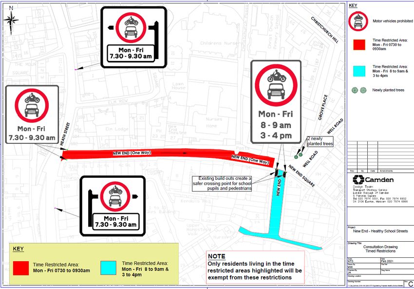
The restricted area where exemptions will still apply is shown in red and blue on the
attached drawing on page 5.
Feedback during the Experimental Traffic Order
Period
Nine comments on the scheme were sent to the council during the Experimental Traffic
Order (ETO) period, from parents, school staff and local residents. Comments in support
of the scheme stated that the streets were quieter on and around New End during the
restricted hours and that traffic issues had improved. Those that objected to the scheme
stated issues regarding traffic displacement, pollution and engine idling, and
parking/access issues. The data highlighted above shows improvements regarding those
issues when the scheme has been in operation.
3
We also sent a short survey to New End School pupils regarding the HSS once it had
been implemented to gather their feedback. Of the 10 pupils that responded, 7 stated that
they liked the scheme. 3 Stated they didn’t like the scheme, one pupil giving the reason
that there wasn’t any parking available near the school. During the pandemic it has been
difficult to acquire feedback from both schools. This is likely due to their having to deal with
a variety of other issues caused by being in and out of lockdown throughout 2020. Further
comments from the schools will be sought as part of this consultation.

What we are now consulting on
Based on the overall positive traffic data during the times of the restrictions, air quality
information, and feedback received during the trial period, we are now consulting on
making the scheme permanent. Details of the scheme are as follows:

   •   Timed road closure at the junction of New End and Heath Street during the
       morning peak times of 7.30am-9.30am Monday to Friday during school term
       time only. This is enforced by using a traffic enforcement CCTV camera placed at
       the Heath Street and New End junction and would remain in place as it is currently.
   •   Timed road closure at the New End T-junction at school opening and closing
       times of 8am-9am and 3pm-4pm Monday to Friday during school term time
       only. This is enforced using a traffic enforcement CCTV camera placed at the T-
       Junction on New End and would remain in place as it is currently.
   •   Build out of pavement at the T-Junction on New End – this would remain in
       place as it is currently.
   •   Two new trees – these would remain in place, near the corner of Grove Place as
       they are currently.
   •   No longer exempting the whole of the CA-H controlled parking zone from the
       restrictions – current exemptions for residents/businesses in the restricted areas
       marked in red and blue on the drawing on page 5 would continue to apply.
       Emergency service and refuse vehicles would also continue to be exempt from the
       restrictions.

How can you give your views?
We would encourage you to give your views via:

Camden.gov.uk/NewEnd
You can access the website via the QR code or if you would like a
paper version of the consultation questions, please call 020 7974
4444 and we will post one to you. If you would like to make any other comments, you can
do so by sending an email to: Healthy.School.Streets@camden.gov.uk
The consultation will close on 30th May 2021. A decision report, considering consultation
responses, relevant policies and other data/information will then be produced and
published online. If approved to be made permanent and prior to implementation, a
Statutory Traffic Management Order consultation will be carried out by advertising the
proposed permanent traffic order in the local newspaper (The Ham and High). The plan
overleaf shows the area of New End that is restricted, along with the restriction timings.
                                                                                                   4
5
New End Healthy School Street Scheme Detailed Information
This document sets out data and other information gathered during the trial period of the
Healthy School Street (HSS) scheme on New End. It has been gathered and analysed to
help assess the impact of the scheme during the trial period of operation. The data and
feedback are summarised below.
Traffic Count Data
Weekly traffic counts (car, van, lorry, bus, cycle and motorcycle) were taken over the
following five-day periods:
The week commencing 10th October 2019 (pre scheme)
The week commencing 10th March 2020 (during scheme trial, before lockdown
started – schools fully operational)
The weeks commencing the 5th, 12th and 19th of October 2020 (during scheme trial
– schools fully operational)
The counts covered the total number of vehicles on a Monday to Friday in school term
time, when all pupils were attending the school. Please note that while the October counts
were taken over three separate weeks, traffic counts were only collected for one week at
each location.
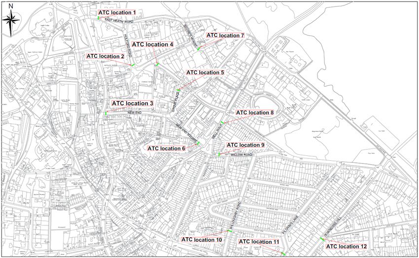
The data count locations are shown in Figure 1 on the final page of this document as
follows (location numbers in brackets correspond to the map in Table 1): East Heath Road
(1), Holford Road (2), New End (3), Christchurch Hill (4), Grove Place (5), New End
Square (6), Squires Mount (7), Well Walk (8), Willow Road (9), Willoughby Road (10),
Pilgrims Lane (11) and Downshire Hill (12).
It is recognised that the Covid-19 pandemic has had an impact on general traffic levels
throughout London and in Camden. Data from Transport for London shows that there was
a 9% decrease in traffic levels across inner London in October 2020 compared to October
2019, after the first lockdown.
The timings and data gathered is summarised in Table 1 overleaf, which show daily
average traffic flows based on the weekly counting periods noted above.
1Table 1 –Traffic Count Data: Daily Average Vehicle Counts (Monday to Friday, AM and PM peaks)
AM Peak (08:00-09:30) PM Peak (14:45-16:15)
Oct Mar Oct Change Change Oct 2019 Mar Oct Change Change
2019 2020 2020 (Oct 19 (Oct 19 (pre 2020 2020 (Oct 19 (Oct 19
Location
(pre (during (during to to Oct scheme) (during (during to to Oct
Map scheme) scheme scheme March 20) scheme scheme March 20)
ref # trial) trial) 20) trial) trial) 20)
East Heath Road (EB) 1 977 943 916 -4% -6% 576 533 557 -8% -3%
East Heath Road (WB) 1 408 452 375 +11% -8% 627 686 499 +10% -20%
Holford Road 2 50 48 5 -3% -89% 25 31 5 +26% -79%
New End 3 211 86 37 -59% -82% 70 51 48 -27% -32%
Christchurch Hill (SB) 4 43 45 54 +4% +26% 23 27 78 +14% +233%
Christchurch Hill (NB) 4 79 72 60 -9% -24% 79 73 138 -7% +76%
Grove Place 5 11 7 8 -30% -26% 7 5 7 -31% 0%
New End Square (EB) 6 191 125 94 -34% -51% 96 94 103 -2% +7%
New End Square (WB) 6 11 29 15 +157% +30% 12 19 18 +60% +53%
Squires Mount 7 7 10 9 +49% +26% 7 8 12 +24% +71%
Well Walk (NB) 8 155 148 134 -5% -14% 146 145 279 -1% +91%
Well Walk (SB) 8 87 79 77 -9% -12% 41 44 60 +6% +44%
Willow Road (WB) 9 96 75 117 -22% +21% 146 153 470 +5% +223%
Willow Road (EB) 9 96 49 54 -49% -44% 146 36 37 -76% -75%
Willoughby Road (NB) 10 97 89 93 -8% -4% 99 98 109 -1% +10%
Willoughby Road (SB) 10 64 81 42 +26% -34% 50 71 58 +41% +16%
Pilgrims Lane (SB) 11 102 71 34 -30% -67% 57 50 42 -13% -26%
Downshire Hill (NB) 12 98 0 134 -100% +37% 167 0 210 -100% +26%
Downshire Hill (SB) 12 381 0 352 -100% -8% 216 0 247 -100% +14%
Total 3,165 2,410 2,610 -24% -18% 2,589 2,124 2,976 -18% +15%
2When comparing the traffic counts from October 2019 to March 2020, it can be seen that
there is a 59% reduction in traffic flows on New End (from the Heath Street junction) during
the AM peak, and a 27% reduction during the PM peak. Across the whole study area,
traffic flows were reduced by 24% in the AM peak and 18% in the PM peak.
Comparing traffic counts from October 2019 to October 2020 shows an 82% reduction in
traffic flows on New End (from the Heath Street junction) during the AM peak, and a 32%
reduction during the PM peak. Across the whole study area, traffic flows were reduced by
18% during the AM peak (the Heath Street/New End restriction operates in the AM peak
only). Some of this decrease from October 2020 may be attributed to general changes in
car use in inner London following the first lockdown, as demonstrated by Transport for
London’s data showing a 9% decrease in traffic levels across inner London in October
2020 compared to October 2019.
During the PM peak, the only Healthy School Street vehicular restriction in operation is the
closure of the short section of New End leading down to New End Primary school from the
T-Junction near the new build out (and not the restriction on New End at the junction from
Heath Street, which operates in the morning only). As such, the increases in traffic
recorded in the PM peak throughout the wider area (comparing October 2019 to October
2020) are unlikely to be attributed to the New End Healthy School Street scheme.
The Council will undertake a study, separate to this consultation, to identify possible
causes of this increase in traffic across the area observed in the PM peak from the
October 2020 data. Subject to findings of this study, a consultation on further measures
may be considered which could include, but not be limited to, a potential Healthy School
Street on Christchurch Hill.
The Council has also approved a temporary footway widening scheme directly outside of
Christ Church Primary School on Christchurch Hill. This is due to be implemented in March
2021. This will provide additional space for parents and carers to safely social distance
during drop off and pick up times.
Air Quality Data
Air quality diffusion tubes have been in place on New End (Streatley Place), New End
(New End T-Junction near the widened footway implemented as part of this scheme), and
Christchurch Hill since January 2019. Diffusion tube data is a standard and approved
method for measuring ambient NO2 concentrations.
Table 2 presents a comparison of raw average unadjusted diffusion tube data collected
from January to February 2019 and September to October 2019 before implementation of
the scheme, and from January to February 2020 and September to October 2020 post
implementation.
3Table 2 – Air Quality Data
Monitoring site Jan-Feb 2019 Jan-Feb 2020 Change
(µg/m3) (µg/m3) (µg/m3)
New End – Streatley Place 39.64 30.20 -9.44 (-24%)
New End – New End T-Junction 39.83 32.00 -7.83 (-20%)
Christchurch Hill No data for Jan- No data for Jan-
27.60
Feb 2019 Feb 2019
Monitoring site Sep-Oct 2019 Sep-Oct 2020 Change
(µg/m3) (µg/m3) (µg/m3)
New End – Streatley Place 26.49 22.08 -4.41 (-17%)
New End – New End T-Junction 28.89 25.18 -3.71 (-13%)
Christchurch Hill 25.17 22.39 -2.78 (-11%)
There is an improvement in air quality at all three monitoring locations. The data shows a
reduction of μg/m3 by at least 11% across all sites (with the exception of Christchurch Hill
due to data limitations). The biggest changes in air quality were recorded at Streatley
Place, near to New End School, where 24% reductions in μg/m3 were recorded.
4Figure 1 – Location of Traffic Counts
5Responding to the challenges of Covid-19 in your neighbourhood
Speeding is the main
We want to keep your cause of road death. BAME Londoners are more at risk of
being killed or seriously injured,
neighbourhoods safe 21,260 BAME children are on average 1.5x
from speeding... more likely to be affected than none-
BAME children.
PLEASE 8531
SLOW YOUR
SPEED
2019 2020
43 London speeding
enforcements till August
(149% increase)
...so we are reducing traffic
in residential streets
Covid-19 is causing extra cars across Camden...
and it's getting busier on our streets 38% of people at risk of
deprivation, 36% of women
TfL estimates if all car owning households and 31% of disabled people
switched their usual public transport who don’t cycle said they'd
journeys to cars there would be like to give it a go
nearly double the traffic in Camden
plus extra from other boroughs
Supporting Camden residents to travel sustainably Camden residents love
their bikes
8/10 trips by Camden Almost 50% of journeys
by Camden residents are Weekday cycling at 2 locations in
residents are not made Camden have seen an average
by car. on foot or by bike.
increase of 106% this August to last.
Children want to travel
healthily and safely to school
In Camden, 69% of households don't have a car, so We surveyed 14 local schools and
providing safe and easy walking and cycling facilities is 51% of pupils walked, scooted
crucial. or cycled to school.
We want you Health is everything
to breathe easy....
42% of Camden residents are overweight
Breathing in polluted or obese, increasing the risk of
air can have short Lockdown measures led to a 53% severe illness and death from
and long-term impacts reduction in traffic levels in London, COVID-19.
on our health, at any reducing the overall level of pollutants Just a 20-minute walk can prevent
stage in our lives. in our air. We want to see air quality long-term health conditions like Type 2
improvements continue now lockdown diabetes, heart disease and certain
has eased. cancers, as well as
being good for your
20
mental health.
minsFind out more
To find out more on how we are making travel safer
in Camden visit:
www.camden.gov.uk/making-travel-safer-in-camden
safetravel@camden.gov.uk / 020 7974 4444
To give your suggestions and feedback visit:
safetravelcamden.commonplace.is
To learn to cycle for the first time, improve your
cycling skills or for a bike loan to help you get on
your way visit:
www.camden.gov.uk/cycling
Transport Strategy Service, London Borough of Camden, Town Hall,
Judd Street, London, WC1H 9JEYou can also read