Snow water equivalent retrieval using satellite sensors and climate trends of snow mass
←
→
Page content transcription
If your browser does not render page correctly, please read the page content below
Snow water equivalent retrieval
  using satellite sensors and
 climate trends of snow mass

                 Kari Luojus, Finnish Meteorological Institute

Contributors: Jouni Pulliainen, Matias Takala, Juha Lemmetyinen, Mikko Moisander,
                Pinja Venäläinen (Finnish Meteorological Institute)
               Chris Derksen, Colleen Mortimer, Lawrence Mudryk
                       (Environment and Climate Change Canada)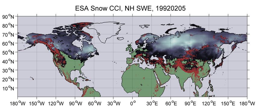
Snow water equivalent retrieval using satellite
sensors and climate trends of snow mass

Contents:

1) Snow water equivalent retrieval using satellite sensors

2) Current efforts to improve state-of-the-art satellite-based SWE retrieval

3) Bias-correction method & improved knowledge of the NH Snow Mass
Background on Passive microwave SWE
     monitoring
• Typical empirical SWE algorithms utilize channel difference (basis Chang et al. 1987)
     • 37 – 19 (V or H pol)
     • 19 – 10 (V pol)

• Currently available satellite-based Hemispherical SWE datasets
     • GlobSnow daily SWE from 1980 – present (FMI)
     • AMSR-E daily L3 Global SWE dataset from 2002 – present (NASA/NSIDC)

• Instrument record: SMMR (1978-1987), DMSP SSM/I, SSMIS (1987->), AMSR-E/AMSR-2
     • Continuity: US/DMSP, JAXA GCOM, Chinese FY-3-series include similar sensors

• SWE Retrieval issues
     •   Coarse resolution
     •   Performance for shallow and deep snow packs (saturation of 37GHz scatter on deep snow)
     •   Varying vegetation, land use and lakes effect SWE retrievals (challenge of resolution)
     •   Regional adaptations do not perform on global scale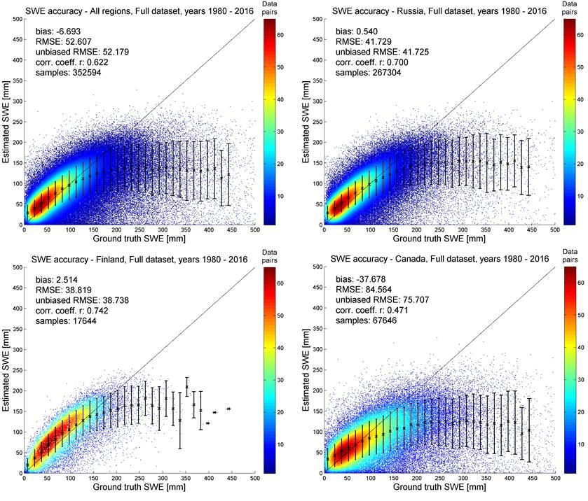
Snow Water Equivalent retrieval using
     data assimilation approach

• An approach published in Remote Sensing of Environment by Prof. Pulliainen
  (2006), refined in Takala et al. 2011
• Nature (2020) publication on NH Snow mass trends builds on this method
• The method utilizes
   • Microwave Radiometer data (SMMR, SSM/I, SSMIS)
      • 19 GHz (V-pol) & 37 GHz (V-pol and H-pol)
      • Time-series for 01/1979 – present day
   • Weather station-based snow depth observations
   • HUT snow emission model (Pulliainen et al. 1999)
ESA GlobSnow algorithm by FMI
(applies data assimilation)
 Dataset                                      Source
                                                                                 • Based on inversion of physical snow
                                                   SMMR, SSM/I, SSMIS
 Brightness temperature
                                                 L3 EASE gridded brightness
                                                                                   emission model (Pulliainen et al., 1999)
 (18.0/19.4, 37 GHz, H and V polarizations)
                                                       temperatures              • Physical model calibrated over weather
 Snow mask                                             IMS and/or NPP VIIRS
                                                                                   station locations (effective grain size)
                                                                                     • Grain size field extended over area
 Global forest fraction                          Derived from ESA GlobCover
                                                                                        of interest using Kriging technique
                                                Global average 70 kg/m3 (v2.0)
                                                                                 • Final step includes assimilation of snow
 Global Forest Biomass
                                                   ESA BIOMASAR (v2.01)            depth background field and radiometer
                                                                                   derived SWE estimates
 Land, ocean and ice mask                        Derived from ESA GlobCover

                                                 Derived from ETOPO5 data
 Mountain mask
                                                       (Etopo5 1988)
                                                   Synoptic weather station                                        References:
 Snow depth from weather stations
                                                        observations                                    Pulliainen et al., 1999
                                                                                                              Pulliainen, 2006
                                                                                                            Takala et al., 2011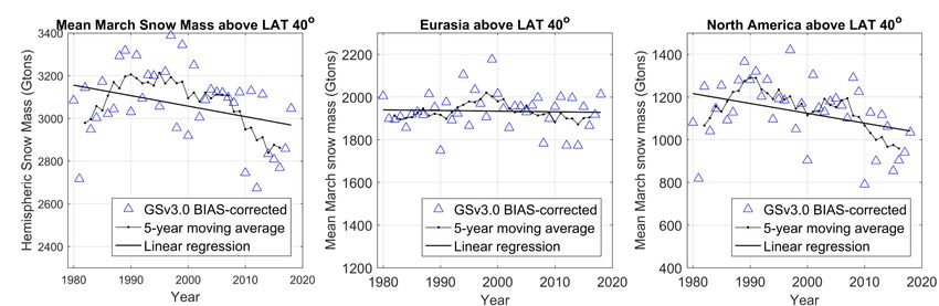
Data assimilation method (I)
• A Bayesian data assimilation approach:
• By searching the maximum value of the conditional probability of SWE for the
location under investigation given the time series of radiometer observations
and in situ observations:
max ( SWE | radiometer observations, in situ SD observations)
• Requires that radiometer observation can be modeled as a function of snow
depth and snow density (SWE)
• Spatial data analysis methods (kriging interpolation) applied for interpolating
spatially continuous snow depth values from discrete in situ observations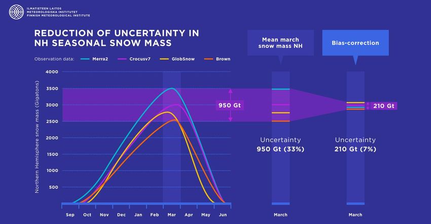
Data assimilation method (II)
• A three step procedure:
First step: Estimation of SD at the locations of reference (in situ) stations
     • By fitting the modeled brightness temperature difference between two channels (Tb,18.7GHz,V-pol
        – Tb,36.5GHz,V-pol) to the corresponding true SSM/I observed channel difference by optimizing
        the value of snow grain size
     • Yields information on the spatial behavior of snow grain size: average snow grain size and
       its variance for different dates for any location (x,y)
           • the variance is estimated through linearizing the relation between brightness
             temperature and snow grain size (Taylor series)

Second step: Determination of SD estimate and its variance from in situ data for any location (x, y) by
  kriging interpolation

Third step: Estimation of SD and SWE for the location (x,y) and for the moment of time (day) by weighing
  different data sources by their estimated variances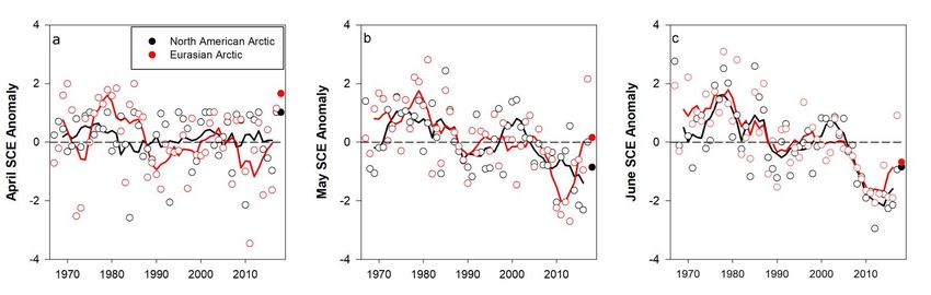
The HUT snow emission model
• Background
     • Semi-empirical model simple enough to be used for parameter retrieval
       from space-borne or airborne data
• Basic characteristics
     • scalar radiative transfer model
       for single snow layer
     • semi-empirical formulas for snow
       permittivity and extinction coefficient
     • empirical coefficient for radiation
       contribution scattered in snow layer
     • incoherent approach used for
       medium boundary effects
     • soil-snow reflectivity by empirical
       soil emission models
     • empirical formulas for atmospheric
       and forest cover effect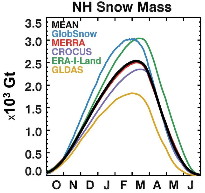
Flowchart of the retrieval approach

                                                                          (4) Kriged SD map
        (2) Weather station                                               & SD variance map
        obs. (SD)

(1) Satellite
observation
                                     (3) Kriged grain size                     (5) Vegetation
                                     background & gs                           background map
                                     variance map

                                                             SD/SWE estimate
                       HUT emission model applied
Flowchart of the retrieval approach

                      Step 1: mountain mask, water mask &
                      filtering
                      Step 2: Retrieval of effective grain size
                      Step 3: Kriging interpolation of effective
                      grain size
                      Step 4: Kriging interpolation of weather
                      station snow depth
                      Step 5: Dry snow detection
                      Step 6: Retrieval of SWE
                      Step 7: Snow area masking
40 year-long CDR time-series of Northern Hemisphere
snow conditions (ESA GlobSnow / Snow CCI SWE)
• First time reliable daily spatial information on
SWE (snow cover):
- Snow Water Equivalent (SWE)
- Snow Extent
- 25 km resolution (EASE-grid)
- Time-series for 1979-2019
• Passive microwave radiometer data
combined with ground-based synoptic snow
observations
• Greenland, glaciers & mountains masked
out
• Openly available (CCI data repository)
• Demonstration of NRT production started on
October 2010 (now within EUMETSAT /
Copernicus services)Snow CCI SWE v1.0 product time series
• Snow variable:
• Snow water equivalent (SWE)
• Uncertainty estimate (STD of SWE estimate)
• Retrieval algorithm: GlobSnow v3.0
(publication in review)
• Time series:
• Start: 6 January 1979
• End: 31 May 2019
• Spatial:
• Coverage: Northern Hemisphere
• Grid size: 0.25°
• Projection: Geograph. (lat/lon)
• Datum: WGS 84
• Temporal resolution: 1 day
• Aggregation: Monthly (+bias correction)
• File format: NetCDF4, CF-v1.7
• Metadata: Land/sea mask, SWE uncertaintySnow CCI SWE - spring 2010 animation
Accuracy characterization of the SWE product
 • Product absolute accuracy determined from
   independent multi-decadal (1980-2016) snow
   transect dataset from Russia, North America
   and Scandinavia

All samples    Number of           Bias            RMSE       Correlation          Mean SWE
               data pairs         [mm]             [mm]           (r)                [mm]
All regions   352 594       -6.7              52.6           0.62              89.0
Russia        267 304       0.5               41.7           0.70              79.9
Finland       17 644        2.5               38.8           0.74              93.9
Canada        67 646        -37.7             84.6           0.47              123.7

SWE
Snow water equivalent retrieval using satellite sensors and climate trends of snow mass Contents: 1) Snow water equivalent retrieval using satellite sensors 2) Current efforts to improve state-of-the-art satellite-based SWE retrieval 3) Bias-correction method & improved knowledge of the NH Snow Mass
ESA Snow CCI - SWE retrieval updates (up to date)
    •   Processing chain adaptation to lat/lon gridding and to cover full NH (0-90°N latitudes)
    •   Improved snow emission model within SWE retrieval (improved forest & lake considerations)
    •   Updated SD synop database: significantly more consistent long term time-series of SD data
        from mutliple sources (ECMWF, NCDC, RIHMI-WDC, Canada, etc.)
    •   Utilization of SCE information to augment SWE retrieval
    •   The ESA Snow CCI SWE v1.0 CDR (1979-2018) available via the ESA CCI data portal
ESA Snow CCI - further development of SWE
retrieval for climate applications
Further development efforts for SWE:
• Improved spatial resolution (0.10°)
• Utilization of enhanced resolution input data
• 12.5km EASE2 “SIR” data
• Dynamic snow density
• Utilization of spatially and temporally
dynamic snow density in SWE retrieval
• Synergistic utilization of optical snow
extent data in SWE retrieval
• JAXA & Snow CCI SCE datasets applied to
enhance SWE retrieval
• Updated/homogenized input datasets
• Monthly bias-corrected productDynamic snow density in SWE retrieval
• Temporally and spatially dynamic snow density reconstructed from multidecadal snow transect data
(Eurasia & North America)
• Applied in SWE retrieval (instead of constant snow density)
• Applied as post-production step
(implemented)
• Applied within SWE retrieval (efforts
on-going)Improved spatial resolution:
25 km EASE-grid -> 12.5km EASE2
• Utilization of the SIR enhanced resolution input Tb data from NSIDC (Brodzik et al. 2016)
• Preliminary validation results below: 12.5km enhanced resolution SWE product
-> (significantly improved SWE retrieval accuracy!)
Snow CCI preliminary validation: Oct.–May 2000 – 2010
- 25km vs. 12.5km dynamic snow density productSnow water equivalent retrieval using satellite sensors and climate trends of snow mass Contents: 1) Snow water equivalent retrieval using satellite sensors 2) Current efforts to improve state-of-the-art satellite-based SWE retrieval 3) Bias-correction method & improved knowledge of the NH Snow Mass
Changes in Snow Cover Extent:
- Arctic & Northern Hemisphere
Arctic Snow Cover Anomalies 1967-2018
The Arctic snow cover extent has been declining in the past decades,
especially in May and June
Source: NOAA Artic Report Card (C. Derksen & L. Mudryk)
Snow Cover Extent is
significantly decreasing! Northern Hemisphere Snow Cover Extent
->June SCE has seen a dramatic decrease!
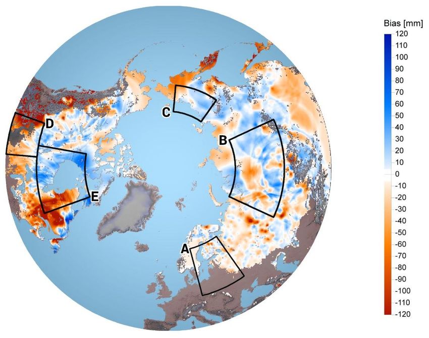
Source: Rutgers University Snow LabUncertainty in NH Seasonal Snow Mass
Spread in NH snow mass between model-based and Satellite-based estimates (ESA SnowPEx)
-> One of the key goals of the SnowPEx & Snow CCI projects was to reduce this uncertainty!
~1200 Gt
Satellite-based GlobSnow/Snow CCI SWE estimate Models vs. “Satellite-based“ dataUncertainty in NH Seasonal Snow Mass Goal: Accurate determination of the NH snow mass and its changes over the past 40 years (using available satellite-, model- & surface-based obs.) • Satellite & model estimates disagree -> Peak-SWE uncertainty: ESA SnowPEx ~1900-3100Gt • With such a high uncertainty – reliable trend analysis is very challenging! • A new approach: Bias correction of the satellite-based data with surface-based reference data (snow transect data from Fin/Can/Rus)
Bias-correction of the SWE CDRs                                                     (satellite + models)
 •    A bias-correction procedure that utilizes independent snow course observations has been developed and applied to the
      satellite-based SWE CDR (~2200 snow courses over NH)
 •    Assessment of model-based data records undertaken as well -> overall uncertainty of the overall NH snow mass conditions
      better constrained
 •    Significantly reduces the overall uncertainty, brings models & satellite-based climatologies to a very good agreement

Evolution of the annual
bias of GlobSnow SWE
estimates for March
Nature publication on NH snow mass: Reduction of the overall uncertainty The significant spread in NH snow mass between the Satellite and model-based estimates. -> Development of a new bias-correction methodology. Pulliainen, J., Luojus, K., Derksen, C. et al. Patterns and trends of Northern Hemisphere snow mass from 1980 to 2018. Nature 581, 294–298 (2020). https://doi.org/10.1038/s41586-020-2258-0
Nature publication on NH snow mass:
Reduction of the overall uncertainty
  The new bias-correction methodology, significantly reduces the uncertainty.
  -> Allowing us to determine for the first time reliably the trends and patterns of the
  NH snow mass for 1980-2018!

 Pulliainen, J., Luojus, K., Derksen, C. et al. Patterns and trends of Northern Hemisphere snow
 mass from 1980 to 2018. Nature 581, 294–298 (2020). https://doi.org/10.1038/s41586-020-2258-0
Nature publication on NH snow mass:
Reduction of the overall uncertainty
 The bias-correction methodology decreases the overall uncertainty significantly.
 Allows determination of the trends and patterns of the NH snow mass for 1980-2018!

  Pulliainen, J., Luojus, K., Derksen, C. et al. Patterns and trends of Northern Hemisphere snow
  mass from 1980 to 2018. Nature 581, 294–298 (2020). https://doi.org/10.1038/s41586-020-2258-0
Results from bias-corrected satellite-based
SWE CDR for 1979-2018
•   The bias-correction corrects (increases) especially the problematic ”deep snow” SWE estimates
    (typical under-estimation of deep snow is corrected to a significant degree)
Bias-corrected satellite-based SWE mean March
snow mass on northern hemisphere 1980-2018
• The bias-corrected dataset shows: no significant trend for NH for March
• The dataset shows no trend for Eurasia and a slightly negative trend for North America
• Peak SWE hasn’t significantly decreased yet, spring-time snow cover extent has!
Pulliainen, J., Luojus, K., Derksen, C. et al. Patterns and trends of Northern Hemisphere snow
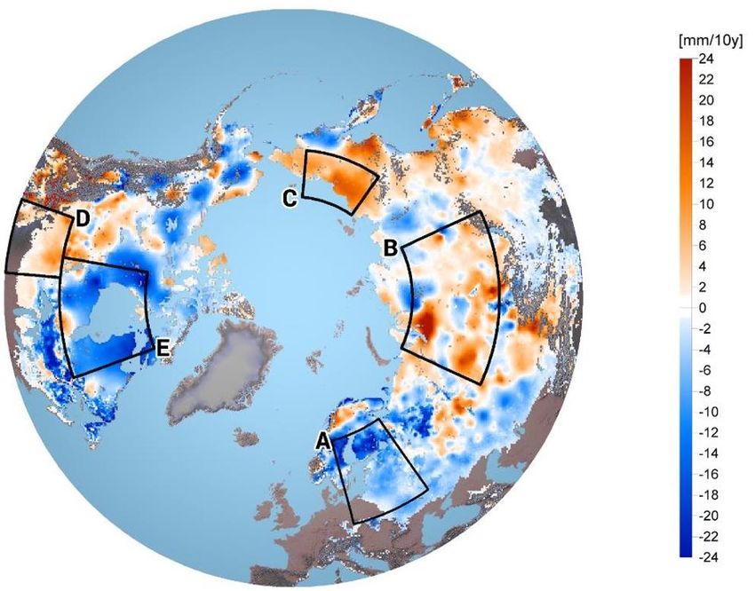
mass from 1980 to 2018. Nature 581, 294–298 (2020). https://doi.org/10.1038/s41586-020-2258-0Long term changes in NH Seasonal Snow Mass (from bias-corrected satellite-based SWE) • Decadal changes in NH snow mass [mm/10 years] High regional variability in snow mass trends on both continents are obvious
EUMETSAT H SAF
H65 SWE NRT
product
FMI participates in the EUMETSAT Hydro SAF
(Satellite Application Facility) with the Near Real Time
SWE product
The current operational SWE product H13 (Pan
European region) will be replaced with Northern
Hemispherical H65 product (brought online during 2021)
The mountains (in the sample image masked out) will
be provided by Turkish State Meteorological Service
(TSMS) -> providing a full NH-wide coverage
Once EUMETSAT EPS-SG satellites are launched
the H65 product will be based on MWI (Microwave
Imager) data
Copernicus Imaging Microwave Radiometer (CIMR)
      Mission Objective
      Respond's directly to the Integrated EU Arctic Policy                                ~Ø6m
      •   Climate Change and Safeguarding the Arctic
      •   Environment Sustainable Development in and around
          the Arctic
      •   International Cooperation on Arctic Issues
      •   Global SST capability

      Characteristics (To be Confirmed)
      -  Conically scanning multi-frequency microwave radiometer
      -  Single satellite, Observation Zenith angle 55±1.5°
      -  Loose convoy flight with MetOp-SG(B) ~300s separation
      -  ~95% global coverage every day, mean 6 hourly-revisit in Arctic Areas
      -  In Phase A/B1, Launch: 2025

      Channels (GHz, all H&V):      1.4, 6.9, 10.65, 18.7             36.5
      Resolution (km):              ≤55     10       ≤10      ≤5       ≤5
      NEΔT (K @150K):              ≤0.3 ≤0.2         ≤0.3     ≤0.3     ≤0.7
      Swath                         > 1900km
      Products (Performance TBC, P=Primary, S=Secondary)
      P1: Sea Ice Concentration (≤5 km, 5%)
      P2: Sea Surface Temperature (10 km, ~0.2 K)
      S: Sea Ice Drift (≤25 km, 3 cm/s)                         FMI participates the on-
      S: Thin Sea Ice Thickness (~40 km, 10%)
      S: Snow on Sea Ice
                                                                 going Mission studies.
      S: Snow Water Equivalent                                   CIMR will be excellent
      S: Sea Surface Salinity (~40 km)
      S: Ice Type (≤5 km)                                          for SWE retrieval!
      S: Extreme Wind
      Additional tertiary products (eg. global soil moisture, water vapour,
      precipitation rate…)

ESA UNCLASSIFIED - For Official Use                                                           CIMR | 12-13/04/2018| Slide 32
Conclusions
Efforts in the ESA Snow CCI project are on-going to improve the retrieval of SCE and SWE records from
satellite data – several updates to earlier “GlobSnow” SWE retrieval methodology
Further R&D: Dynamic snow density, improved spatial resolution, a new bias-correction method
-> significantly improved satellite-based SWE climate data record!
There has been a significant spread in NH snow mass between the satellite and model-based estimates
-> A new bias-correction methodology significantly decreases the NH snow mass
uncertainty -> Allowing us to determine for the first time reliably the trends and patterns of
the NH snow mass for 1980-2018
Key results:
• Overall NH SWE uncertainty ~33% -> 7% [950Gt -> 210Gt]
• Slightly decreasing March NH Snow mass trend for 1980-2018,
driven by changes in North AmericaYou can also read