The Checkered History of the Naming of America
←
→
Page content transcription
If your browser does not render page correctly, please read the page content below
The Checkered History of the Naming of America:
Early 16th Century Forays
Christopher Tyler
This is the second part of the two-part article on the world map can be traced to the spherical triangle concept
early history of the naming of America. In the first found in Leonardo da Vinci's octant map of ~1505 (see Fig.
part (Calafia, Spring 2021), it was shown that the 2 A,B). This map was one of the first to use the name AMER-
name AMERICA was not used at all for the North ICA, though only the South American continent was known
American continent before 1538. Here the gradual at that time, as described in the first part of this article
adoption of the name for each continent is traced up to (Calafia, Spring Issue, 2021). (Da Vinci's map based on
the end of the 18th century. spherical triangles, a minimally-distorted projection within
each octant and was the first to encompass the whole globe in
a single projection, Tyler, 2017) Figs. 2C, D show Oronce
Finé's illustration of how to develop these octants into an
integral form for the similar projection in his Sphaera Mundi
compendium of maps of the world. This concept was evident-
ly the impetus for the cardioid (heart-shaped) projection de-
veloped by German mathematician Johannes Stabius and
first used by Bernardo Sylvanus in 1511 (Fig. 2E, overlaid
with a root pair of da Vinci spherical triangles). Sylvanus fol-
lows da Vinci in using the name AMERICA for the solitary
South American continent.
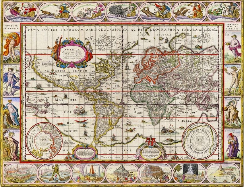
Mercator's double cordiform mappamundi (Fig. 1) also
adds the North American continent missing from both Syl-
vanus' and Finé's earlier versions. As further confirmation of
Figure 1. Gerhard Mercator, World map on double cordiform pro-
jection, 1538. Image courtesy of Wikimedia Commons.
its connection back to Leonardo da Vinci, Mercator's map is
unique among its predecessors in using all three of da Vinci's
A lthough the name AMERICA was first introduced early
in the 16th century to honor explorer Amerigo Vespuc-
ci, it was not applied to both continents for three decades
territorial labels in this northern region: AMERICA, Terra
Florida, and Bacalar (lower left quadrant in Fig. 1), though in
slightly different forms. Moreover, he follows da Vinci in
until it appeared in a baroque cartographic projection by showing the north coast of Africa as an almost unitary curve,
Gerhard Mercator in 1538 (Fig. 1), a the name of a very minimizing the major deflection of the coastline from Tunis
different form from the famous cylindri-
cal projection that he developed 30 years
later. Nevertheless, it soon dropped out
of regular use, even for the southern con-
tinent, until the turn of the 17th century
and was only securely established in its
modern usage about a century later. It is
particularly noteworthy that even Amer-
igo Vespucci's nephew, Juan Vespuche,
avoided the use of the term AMERICA
for either the South or the North Amer-
ican continents in both his 1524 and
1526 world maps.
Figure 2 A,B. Figure 2 C, D. Octants Figure 2 E. Root pair of da Vinci spher-
From da Vinci’s to integral form, Oronce ical triangles overlaid on the cardioid
The Origin of the Mercator Double octant map, c. 1505 Finé, 1531 projection of Sylvanus, 1511
Cordiform Projection
We can ask where Mercator gained the impetus to apply the to the Gulf of Sidra. These features confirm that Mercator
name AMERICA to the North American continent. The must have somehow had access to da Vinci's original concep-
inspiration for his curious double-heart-shaped form of tion, although Mercator uses the label AMERICAE, the plu-
Page 1 Calafia Journal Volume 2021, issue 2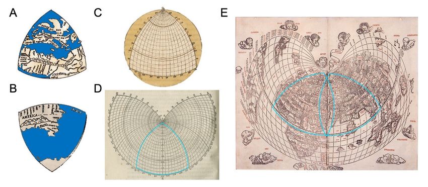
ral form in Latin for “The Americas,” for both the North and
South American continents (see Fig. 1). It was not until thir-
ty years later that Mercator developed his famous cylindrical
“Mercator projection” in 1569. By that time, however, he had
dropped the AMERICAE designation and, even at this late
date, labels the two continents INDIA NOVA!
    Similarly, as documented in the name usages tabulated in
Table 1, many well-known cartographers of the mid-16th
century avoided committing to any name for the progressive-
ly extending knowledge of the continent (such as Jerome
Münster, Pierre Desceliers, Sebastian Caboto, Guillaume Le
Testu, and Urbano Monte). Remarkably, by the late 16th
century, the world maps of Abraham Ortelius (1570, oval
format), Rumold Mercator (1587, Gerhard's son), and Jo-
codus Hondius (1595) had even gone further to adopt the

                           Table 1                               Figure 3. Willem Blaeu, Nova Totius Terrarum Orbis Geographica
                                                                 ac Hydrographica, 1606. Image courtesy Nations Online Project.

                                                                 reverse strategy of dropping the AMERICA designation for
                                                                 the South American continent and use it only for the North.
                                                                 Until the 17th century, the only cartographers to use the
                                                                 name again for both the northern and southern continents
                                                                 were Sebastian Münster in 1569 and Cornelis de Jode in
                                                                 1593. Conversely, de Jode's map of North America, although
                                                                 entitled “AMERICA PARS BOREALIS, FLORIDA, BAC-
                                                                 CALA, CANADA CORTEREALIS,” actually names the
                                                                 northern continent FRA[N]CIA NOVA (curiously mis-
                                                                 spelling the country designation). Thus, other than Münster
                                                                 and de Jode, the later 16th century still evinced a surprising
                                                                 dearth of the use of the name AMERICA for either the
                                                                 northern or the southern continents of this burgeoning land-
                                                                 mass.1

                                                                 Establishment of the Dual-Continental Nomenclature
                                                                 The dawn of the 17th century seemed to give the name
                                                                 AMERICA a new lease of life, beginning with the world map
                                                                 of Willem Blaeu, in Latin (Fig. 3), first published in Amster-
                                                                 dam in 1606. It is noteworthy that the North American con-
                                                                 tinent in this map has now ballooned to greater than the com-
                                                                 bined widths of Europe and Asia and still has a rather shaky
                                                                 grasp on the form of the coastline of its eastern seaboard. In-
                                                                 terestingly, California, which had been recently explored by
                                                                 Cortès, is shown in its true configuration of a peninsula at
                                                                 this early date. In terms of nomenclature, Blaeu's (1606) map
                                                                 introduced the unwieldy phrase AMERICA SEPTEN-
                                                                 TRIONALIS for the northern continent, accompanied by
                                                                 AMERICA MERIDIONALIS for the southern one (the two
                                                                 Latin adjectives being astronomical terms for 'north and
                                                                 'south', respectively). This Latin formulation gained populari-
                                                                 ty for the remainder of the 17th century (see lower section of
                                                                 Table 1).

     Volume 2021, issue 2                                  Calafia Journal                                       Page 2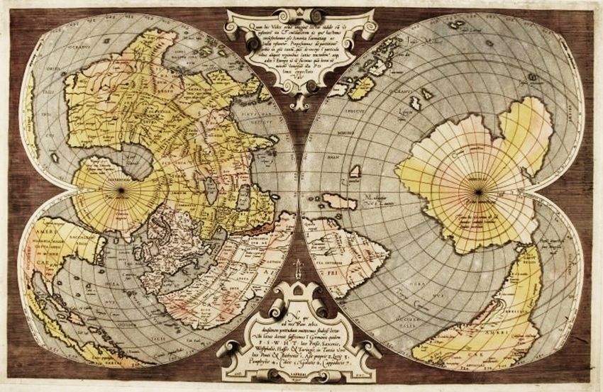
The 18th century saw a new tradition of simplifying the sporadic use for both continents, starting with Mercator's
names to their modern forms of South America and North early mappamundi of 1538 but, paradoxically, tended to be
America, thus continuing the convention begun by Mercator, applied only to the northern continent later in that century.
in 1538, of treating the whole hemisphere as a single meg- It was reintroduced in its Latin form for both continents at
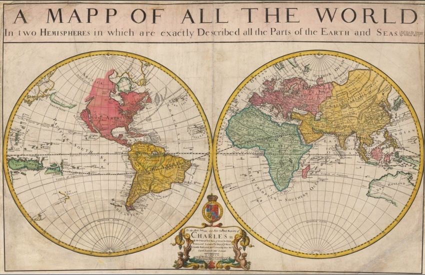
acontinent. The first example seems to be the double- the turn of the 17th century and was first used in its English
hemispheric globular map (Fig. 4) by London cartographer form of NORTH and SOUTH AMERICA in William Ber-
William Berry (1680). Note that, although the Americas are ry's world map in 1680. However, this modern English usage4
considerably more realistic than a century earlier, California, did not become securely established until the end of the 18th
which had been viewed as an elongated peninsula for a centu- century.
ry or more, was now reconfigured by Berry as an island2.
Moreover, only half of Australia had been mapped by this References
time, by Dutch traders who had named it New Holland. This Bergau R. (1879) Glockendon oder Glockenton [Nürnberger
format was shortly followed by Berry’s collaborator Herman Künstler-Familie], Allgemeine Deutsche Biographie
Moll's (1703) world map celebrating the English circumnavi- (ADB) (in German), 9, Duncker & Humblot: Leipzig, p.
gations of Drake more than a century earlier, together with 238.
two later ones. Many of Berry and Moll's maps were dedicated Finé O. (1531) Sphaera Mundi. Paris.
to Queen Anne of England, whose imperial aspirations ranged Moll H., Midwinter D. (1730) Composite Atlas. Bowles:
from Ireland to India, France, and parts of the Americas. London.
From Ruderman's 2017 biography of Moll3, we learn that Ruderman B.L. (2017) Antique maps by Herman Moll. Rare
their circle of coffee-house friends included the scientist Rob- Maps Website: https://www.raremaps.com/
ert Hooke, the archaeologist William Stuckley, the renowned mapmaker/107/Herman_Moll (accessed 2/2/21).
adventure authors Jonathan Swift and Daniel Defoe, and the Tyler C.W. (2017) Leonardo da Vinci's world map: On the
English explorer/pirates William Dampier, Woodes Rogers, neglected scope of his global cartographic projections.
and William Hacke. Through these contacts, Berry and Moll Journal of the International Map Collector's Society. 149,
gained a great deal of privileged cartographic information that 21-31.
was included in their maps. Tyler C.W. (2019) Was Leonardo da Vinci's world map the
first to name America? A quincentennial reappraisal.
Calafia, 2019(2), 7-12.
Tyler C.W. (2021) The checkered history of the naming of
America: Early 16th century forays. Calafia, 2021(1), 12-
15.
Endnotes
1
Note that Table 1 represents a good-faith effort at a compre-
hensive overview of world maps from the 16th through 18th
centuries, but some will inevitably have been missed, so they
should be considered to be only representative of the full list.
2
California was first depicted as an island by Antonio de
Herrera y Tordesillas in 1622, after 80 years of being consist-
Figure 4. William Berry, A Mapp of All the World, 1680. Image
ently mapped as a peninsula.
3
courtesy of the New York Public Library. The close collaboration between William Berry and Herman
Moll is attested by the Composite Atlas compiled by Berry,
Conclusion Moll, and fellow cartographers, containing a total of 64 maps
The cartographic use of the name AMERICA for the two con- and seven leaves of geographical tables, which sold at Chris-
tinents of the Western Hemisphere has had a surprisingly tie's in 2013 for £47,475 (https://www.christies.com/en/lot/
checkered history in the two centuries since the name was lot-5685675).
4
introduced in the first decade of the 16th century. It was used As may be noted from Table 1, world maps from non-
only sporadically for the southern continent in the prolifera- English speaking countries typically labeled the American
tion of world maps for the next thirty years, was not applied continents in Latin toponyms rather than their own lan-
to the northern continent at all in this period, and soon guage.
dropped out of regular use even for the southern continent
(Tyler, 2021). The name AMERICA then came back into
Page 3 Calafia Journal Volume 2021, issue 2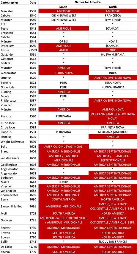
You can also read


