The Top 10 Places in the San Juan and Gulf Islands You Don't Want to Visit!
←
→
Page content transcription
If your browser does not render page correctly, please read the page content below
Northwest Cruising Destinations

The Top 10 Places in the
San Juan and Gulf Islands
You Don’t Want to Visit!
Story by Mark Bunzel
During last season we looked at some of the highly recommended scenic harbors and anchorages to visit in the San Juan
Islands. Now that you are settled by the fireplace, your boat tied safely to the dock, on the hard, or in storage for the winter,
it is a good time to think about next season. Before we start describing more of the special places in the San Juan and Gulf
Islands you really should visit, this month and next we will look at the places you really don’t want to visit.

The question, “Have you ever run aground?” immediately draws either the feeling of fear or arrogance when it comes up in
conversation amongst boaters. Fear, as many of us wonder when it will happen to us, or we immediately think back to the
time when it did happen. Arrogance is the reaction from those who think, “It will never happen to me”.

The truth is it happens to many of us. The old saying goes “if you haven’t run aground – it is only a matter of time before
you will!” According to BoatU.S.’s Director of Boating Safety, Chris Edmonston, it happens about 1200 time a year where
there is an injury or damage claim. Experts estimate there are 10 times or more as many groundings, often where there is
minimal or no reported damage other than a bruised ego for the captain. As the pictures show, it happens to many boaters
ranging from the inexperienced to the very experienced, in small boats as well as large.
                                                                                             Top 10 Places You DON’T Want to Visit!
                                                                                                      in the San Juan & Gulf Islands
                                                                                                      © 2004 Mark Bunzel – Page 1
So, let’s take a look at some of the places you don’t want to visit in our Pacific Northwest cruising area. Some, you know of,
some may be a surprise. I talked to a number of experts ranging from U.S. and Canadian Coast Guard personnel, Vessel-
Assist tow boat specialists, and the many charter operators in the area. The local charter companies each maintain their own
list of areas they don’t want their customers close-to as there have been too many un-intentional groundings. I also talked to
experienced boaters in the area. The common comment was almost always the same, “How could anyone run into trouble
there. It is so well marked and prominently shown on the charts”. Yet, each person we talked to also had a story either about
themselves or someone else they knew who did run into trouble somewhere in the cruising paradise of the Pacific
Northwest.

We also found several common trends in boat groundings. Captain John Aydelotte of Vessel-Assist Northwest said the
most common problems he saw were related to what he termed as “thin water”. The south end of the Swinomish Channel,
or the shallow areas along the west side of Whidbey Island are popular “stopping points” for his best customers. Inattention,
or a distraction are the common cause for striking rocks in the islands. Sometimes an activity as simple as pointing out a seal
poking it’s head up or basking on the rocks has lead to striking a
rock. Next comes, complacency and denial. It is a beautiful day…          Top 10 Places You Don’t Want to Go
the boat is running great… and crunch. Or, the feeling of well
being that it could never happen to me. Constant vigilance and
                                                                             1. Wasp Islands
attention are key to avoiding an accidential grounding and the
damages to your boat or injury to you and your crew that could
                                                                             2. Pole Pass
result.                                                                      3. Mosquito Pass
                                                                                  4.  Fisherman Bay
While this Top 10 list is not a strict ranking, here are several of the           5.  Johns Pass
most notorious places first which you either want to avoid, or                    6.  Blind Bay
where vigilance, prudence, and extra caution are advised. Several                 7.  Brentwood Bay
places are worth the extra vigilance as they are typically on the key             8.  Ganges Harbour-Long Bay &
routes to many of the must see places in the San Juan and Gulf                        Money Makers Reef
Islands.                                                                          9. Silva Bay
                                                                                  10. False Narrows
1. Wasp Islands and Wasp Passage
While well known as a problem spot, Captain Les Soland of Vessel-Assist San Juan was called on 8 times last season to
pull boats off the rocks in this area. The most notorious spot in Wasp Passage is around Yellow Island, particularly on the
rock strewn west side. Owned by the Nature Conservancy, Yellow Island is small and pretty with visitors permitted by
reservation only. According to Captain Soland, there is typically an orange floating buoy on the west side to warn of the
                                                                       dangerous reefs. But if you get within 30 feet of the
                                                                       buoy it may already be too late. The recommended
                                                                       strategy is to give Yellow Island a wide berth. To the
                                                                       south is Shirt Tail Reef, the scene of the memorable
                                                                       grounding of the classic motor yacht, the Malibu, in
                                                                       recent years. While Shirt Tail Reef is marked it still
                                                                       seems to claim a few victims every year or two.

                                                                           What is the best route to transit the Wasp Islands?
                                                                           Follow the same route the Washington State Ferries
                                                                           use following Wasp Passage to the south of Crane
                                                                           and Cliff Islands past the G “3” and G “1” lighted
                                                                           markers. This route appears narrow at times, but the
                                                                           route is marked with navigational aids and can be
                                                                           transited linearly. It is interesting to note on the charts
                                                                           that the passage between Cliff Island and McConnell
                                                                           Island is deeper and appears wider. But this requires
steering a curved route past obstacles that do not appear on the surface. On the chart it appears easy to follow the curve but
in reality the visual references that appear so clear on the chart are often awash or lurking underwater on this route. Unlike
the route to the south, there are no navigational aids to help select your turn points. Steering a curved route is hard when you
                                                                                                Top 10 Places You DON’T Want to Visit!
                                                                                                         in the San Juan & Gulf Islands
                                                                                                         © 2004 Mark Bunzel – Page 2
have limited visual references. You can pass through with good vigilance, attention to the depth sounder and reference to a
GPS chart plotter. But the record shows that this is an area where good captains with good boats do run aground.

2. Pole Pass
Want to avoid the Wasp Islands and Wasp Passage when heading west from Harney Channel? It is easy. Take Pole Pass.
When heading west, the buoys approaching Pole Pass warn you to keep your speed below 5 knots just past Bell Island, and
begin to set the stage for increased vigilance. Pole Pass is narrow, only about 75 yards at its narrowest, often with current
running through the pass. There are rarely problems in Pole Pass as everyone is watching carefully and transiting at slow
speed. But take a look at the charts, if you go through the Pass and turn to port to head towards Reef Island there are rocks
just past the Pass and what Captain John Aydelotte refers to as another “thin water” place. At high tide you may pass right
over them. But at mean low tide you may only have a couple of feet of water. Ouch! We regularly see boats proceed slowly
through the pass only to power up when clear and then turn to port. Many are lucky. Some run aground.

The best solution is to continue NW for about ¾ of a mile before turning Port towards the north end of Reef Island if your
headed west. If you headed to Deer Harbor, just continue on a course straight ahead after going through Pole Pass.

                                                                               Shoal

3. Mosquito Pass
The genesis for this article began in a friendly disagreement with a well respected charter operator. He claimed he does not
allow his first year charter customers to transit Mosquito Pass from Roche Harbor to visit the beautiful Westcott and
Garrison Bays. In his experience there have been too many groundings in the past. Other charter operators agreed, thus
typically denying their customers the chance to visit two of the most scenic and popular anchorages in the San Juan Islands.
The answer is really vigilance and better local knowledge. In “Exploring the San Juan and Gulf Islands” cruising guide,
Don Douglass shows a curving route which if carefully followed will avoid the problem areas. Positioning oneself on the
proper course in the fairway through the pass is relatively easy as the shore line on both sides allows for easy reference. The
key is follow the curved route to the R “6” buoy and not navigate directly to it. Likewise, if you are headed to Westcott and
Garrison Bays, do not cut the corner to the left side of R “6” when headed south, and avoid the fouled end of White Point.
Likewise, use vigilance when entering Mosquito Pass from the south by Hanbury Point using a curving route that threads a
                                                                                           Top 10 Places You DON’T Want to Visit!
                                                                                                    in the San Juan & Gulf Islands
                                                                                                    © 2004 Mark Bunzel – Page 3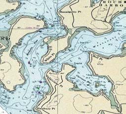
course through R “2” to G “3”, to R “4”. It sounds like basic navigation, but you would be surprised how many boats cut the
corners and run aground.

While the diagram shown on this page illustrates this route very clearly looking at the different charts in the sidebar on
“Consult Your Charts” shows you how one could become confused if quickly referencing the charts with an occasional
glance, while underway. Also, as you will see in the sidebar, the charts can each present a different view based on the map
making style of different cartographers emphasizing some areas and presenting less detail in others. As you will see in the
examples, referencing the charts may not be quite enough and local knowledge from your favorite cruising guide may be
the best assistance.

4. The Entrance to Fisherman Bay
Fisherman Bay, on the west side of Lopez Island is a very pleasant harbor to visit offering two marinas and a well protected
anchorage. But a lack of vigilance at the entrance catches more than a few boats each season. There are two problem areas
situated like a one-two punch; the outside entrance and just inside the entrance all the way to the anchorage. And in case you
are not aware, on a mean low tide you might want to consider waiting before entering or leaving the harbor as you might
find a few times during the month where boats with a draft of more than 4-5 ft. should not even consider using the entrance.
Yet, Fisherman Bay is a wonderful destination and worth making the effort to visit.

Local knowledge and the charts suggest first you do not cut the corner at the Fisherman Bay entrance sector light when
entering from the south. The flat calm water to the harbor entrance to west of the light looks inviting. Don’t do it! Look
carefully at the charts and you will see how shallow the water really is as the sand spit extends out to the sector light. Now
the fun begins, especially when the current is flowing in or out of the entrance. Once inside the sector light, head straight for
the R “4” entrance day beacon on the spit. Stay close to the starboard side of the channel. The current can affect your
steerage at this point, as it did to me one day when the wind and current almost put me sideways in the channel. Past R “4”
stay in the middle of the channel and keep going straight down the middle taking both green marks, G “5” and G “7” wide

                                                                                             Top 10 Places You DON’T Want to Visit!
                                                                                                      in the San Juan & Gulf Islands
                                                                                                      © 2004 Mark Bunzel – Page 4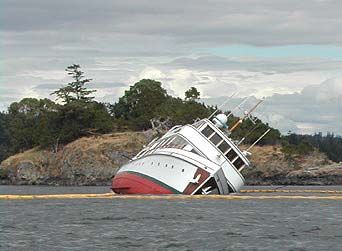
to port. Next, head straight to R “8”. Head past R “8” to starboard and you can head to the marinas or the anchorage area in
the bay.

5. Johns Pass
Prevost Harbor on Stuart Island is another destination worth visiting in the San Juan Islands. But on the southeast tip of
Stuart Island there is an area of what some call “thin water”. It requires the most vigilance when headed south through
John’s Pass. While the pass is narrow, most captains reduce speed and keep a careful watch while transiting the pass it self.
Once you are past the south shore of Johns Island it appears to be open water going forward. Consulting the charts, you can
see the rocks that extend to the east of Gossip Island that regularly cause problems for local boaters not paying attention.
When exiting past Johns Island it is critical to continue southeast, parallel to the shoreline for almost ¾ of a mile before
turning south. The temptation is very strong as you leave the pass to turn, especially if you are headed towards Roche
Harbor.

There are few rocks, if any, and obstructions in the San Juan and Gulf Islands not shown on navigation charts. Reading the
correct scale charts and even interpreting what the charts tell you can be confusing (See sidebar). GPS chart plotters may
increase risks. Rather than studying the big picture for a passage on a chart, setting routes electronically and pushing buttons
without looking at the detail of a route at the smallest scale practical, can lead to an accidental grounding

                                                                          The Top 3 Comments Most Often Stated
                                                                          After Going Aground!

                                                                              1. “Oh Sh**!!”
                                                                              2. “…But I have been through here
                                                                                 so many times before!”
                                                                              3. “My wife was at the helm while I
                                                                                 was down below using the
                                                                                 head…”

                                                                                            Top 10 Places You DON’T Want to Visit!
                                                                                                     in the San Juan & Gulf Islands
                                                                                                     © 2004 Mark Bunzel – Page 5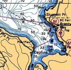
This subject has created a number of interesting discussions at the boat shows and with yachting groups in the
Pacific Northwest. Groundings are a problem – and the most often asked question is “How many groundings do
you think really happen each year in this area?” When you ask the US and Canadian Coast Guards, Vessel Assist
and the tow boat captains, they respond that it happens more often than it should, hundreds of times each season in
the San Juan and Gulf Islands. As you will read in this article, it leads to insurance claims, the loss of millions of
dollars towards repairs, boats sinking, and recently, even two fatalities. The experts say boaters are lulled into
complacency by the false security of visually seeing what appears as a safe passageway across the water. Or,
boaters many times suffer from a lack of vigilance with their situational awareness and they do not consult the
charts. As one expert said – “There are no uncharted rocks in the San Juan and Gulf Islands!”

The next 5 places on our list to fill out the top 10 are:

6. Blind Bay – Shaw Island
Blind Bay is a place you DO want to visit! It is a beautiful, large, protected bay, with a mix of trees and a pastoral
shore typical of Shaw Island. If you are entering Blind Bay from Harney Channel to the east, there is a dangerous
rock, well marked, between Blind Island and the area just west of the ferry docks. This entrance is not the problem
as almost all skippers aim for mid-way between the marked rocks and the mooring buoys to the west along Blind
Island. The problem is when one goes to leave to the west or enter Blind Bay from the west. There is an area of
shoal just to the northwest of Blind Island that is the site of a number of groundings every season. Bob Hale, in his
well respected 2004 Waggoner Cruising Guide, tells his readers a cautious “Do not pass west of Blind Island”. Don
Douglass and Réanne Hemingway-Douglass in their thorough Exploring the San Juan and Gulf Islands point out
that passage to the west of Blind Island is hazardous and recommend alert helmsmanship. They even provide a
suggested route diagram with a careful S-curve course keeping one close to Blind Island and proceeding well out
into Harney Channel before turning. The shoal to the west of Blind Island can be easily avoided. Most who hit the
rocks were fooled by the seemingly clear passage ahead once they left the harbor.

7. Brentwood Bay
The scenarios leading up to an accidental grounding have a common thread. Complacency, and often the goal of
reaching the dock and a cool, frosty beverage once settled in for the day, may cloud good, clear, seamanship. The
scenario for problems at Brentwood Bay may follow a wonderful scenic cruise down Tod Inlet with the intention of
visiting Butchart Gardens the next day. Or, maybe you have just left a wonderful afternoon visiting Butchart
Gardens and now want to take the short passage across the inlet and duck into Brentwood Marina for the night. You
can see the marina and really don’t need to consult the chart – or do you?

                                                                                     Top 10 Places You DON’T Want to Visit!
                                                                                              in the San Juan & Gulf Islands
                                                                                              © 2004 Mark Bunzel – Page 6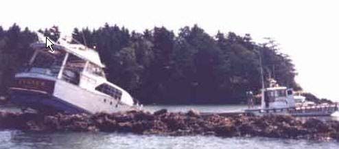
Just in front of the marina is a red nun buoy, U22. Keep this
                                                          buoy to the south of your course. While it is well marked, it
                                                          appears surprisingly close to the entrance to the marina.
                                                          Some are apparently confused by which side of the buoy to
                                                          pass. The management at the new Brentwood Bay Lodge
                                                          tells us that an average of one boat a week hits the reef.
                                                          When you call the marina on VHF a warning about the reef
                                                          is the first thing they tell you. The lesson is, on short hops or
                                                          even when close to reaching the dock, it does not hurt to
                                                          check the charts. The rocks and reefs are lurking out there
                                                          and will get complacent boaters.

                                                         8. Ganges/Long Harbour - Money Makers Reef
                                                         When we first heard about this problem area we thought
                                                         boaters were describing the well known Money Makers
                                                         Rock just off the Salt Spring Marina. Each year this spot
                                                         claims a few boats with mostly scraped bottom paint as it is
very close the marina docks and most boats are typically going by very slowly. It is said to be marked, but some say
that they have visited recently and there are no buoys in place to mark the rocks.

But, according to the Canadian Coast Guard, the real problem area is in the Chain Islands between Ganges and
Long Harbour. Just north of the Third Sister Island is an area of shoal and rocks that over the years has claimed it’s
share of boats. Last fall, it added two fatalities to its score as two boaters attempted to cut through this area in a fast
boat, late in the day, hitting the rocks at full speed. The best advise is not to cut through the Chain Islands. On the
surface the area looks clear, yet as the charts show, lurking below the surface are many areas with rocks and shoal.
We are often complacent thinking that cruising on the water is safe, safer than driving on a solid highway. But
underwater rocks, logs and other obstructions, combined with speed, can lead to fatal results.

9. Silva Bay – Shipyard Rock
Silva Bay is a popular harbor and resort location. For those traveling from Vancouver, it is often their first stop on
the way to the Gulf Islands. For those traveling through the Gulf Islands, it is a pleasant stop after cautiously
transiting through Gabriola Passage. The entrance to Silva Bay can be confusing as the harbor is not visible from
the entrance between Vance Island to the north, and Tugboat Island to the south. Shoal extends from the edge of
both islands with Shipyard Rock in the middle of the entrance channel. Local knowledge suggests giving wide
berth to the north of the beacon marking the rock. The rock extends well past the beacon to a new buoy, U39. Once
past the buoy, you can make your turn and proceed to the Silva Bay Resort, the anchorage area, or to the Royal
Vancouver Yacht Club outstation. Again, don’t be fooled by the apparent clear passage after the Shipyard Rock
beacon. Avoid the temptation and hold your turn until past the new buoy.

                                                                                         Top 10 Places You DON’T Want to Visit!
                                                                                                  in the San Juan & Gulf Islands
                                                                                                  © 2004 Mark Bunzel – Page 7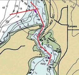
10. False Narrows
                                                                                  False Narrows was nominated by
                                                                                  the Canadian Coast Guard for the
                                                                                  Top 10. One would think the name
                                                                                  and warnings in all of the major
                                                                                  cruising guides would dissuade use
                                                                                  of this route over Dodd Narrows for
                                                                                  transiting north or south to, or from
                                                                                  Nanaimo. But it does provide a
                                                                                  short cut from Gabriola Pass when
                                                                                  headed to Nanaimo. More
                                                                                  importantly, the currents are often
                                                                                  half the strength of the current in
                                                                                  Dodd Narrows making it
                                                                                  particularly of interest if you are
                                                                                  early or late for slack tide. Local
                                                                                  knowledge is highly advised and
extra caution is required at half tide or less in False Narrows. While the channel is well marked with range markers
setting up the north and south approach points to the narrow part of the channel, according to the Canadian Coast
Guard, despite extra vigilance, boats run into trouble often in False Narrows. Sometimes the ebb current will push a
southbound boat into the mid-channel reef. If the natural hazards weren’t enough to contend with, local log tows
sometimes also use this channel instead of Dodd Narrows. Proceed with caution. If you are in a hurry, Dodd
Narrows may be faster to transit depending on the current.

Not everyone agrees with this Top 10. Many who commented for this article have their own favorite place to avoid,
or worse yet, where they have run aground. Running aground is humiliating and costly at the least, dangerous and
life threatening at the worst. The common thread to avoiding an accidental grounding appears to be vigilance,
situational awareness and a careful review of the charts at the smallest scale available for that area. Electronic
charting provides some assistance but is only as good as the user. Some GPS chart plotters don’t offer the detail to
navigate in close quarters. For some, the user may not have the chart plotter on the right scale to fully see the
hazards for the area they are transiting. In some cases the chart plotter may be highly accurate in presenting an
exact lat/long position for the vessel, but poorly positioned on the electronic chart due to reference errors from the
original surveys, soundings and the map making processes over decades of time. Take the attitude that danger may
exist. You know the dangers of crossing over the middle of the road’s centerline when driving. Navigating,
especially through the islands, can be an incredible and beautiful experience. Like the sea, it can be dangerous to
you and your crew without vigilance and respect.

Mark Bunzel is the Publisher and General Manager of nautical publisher, FineEdge.com in Anacortes, WA. Fine
Edge has recently released the 2nd Edition of its best selling “Exploring the San Juan and Gulf Islands” by Don
Douglass and Réanne Hemingway-Douglass to nautical stores and bookstores which covers all of the BEST places
to visit in the San Juan and Gulf Islands.
                                                                                     Top 10 Places You DON’T Want to Visit!
                                                                                              in the San Juan & Gulf Islands
                                                                                              © 2004 Mark Bunzel – Page 8
Consult Your Charts
Okay. Which one?
The common rule of thumb is – use the largest scale chart available to show the most detail for a given area. Scale
is easily recognized when working with paper charts. But when one quickly selects through multiple electronic raster
charts when using electronic charting on a PC, they are already scaled to an area, possibly offering several choices
including Canadian Charts if you have them installed. Mosquito Pass is a good example of the variance between
different government issued charts. The examples below show the differences between the approach taken by
different two cartographers working for the same mapping agency, and then the differences between two different
governments. The challenge for the prudent captain is to correctly interpret the chart, note hazards and obstacles,
and select a route for safe passage for the vessel and its crew. Add wind, current and distractions from the crew and
it is easy to see how mistakes can be made resulting in accidental groundings.

Note: Canadian Charts, as an un-stated policy, do not display navigational aids for US “inland waters” such as
Mosquito Pass. While many prefer the clear and colorful Canadian Hydrographic Charts, where depth contours are
easier to see like Chart 3441 of the San Juan Islands, note that not all navigational aids are shown in Mosquito
Pass.

NOAA Chart 18421                                         NOAA Chart 18433

  Canadian CHS Chart 3441                               Canadian CHS Chart 3462

                                                                                    Top 10 Places You DON’T Want to Visit!
                                                                                             in the San Juan & Gulf Islands
                                                                                             © 2004 Mark Bunzel – Page 9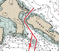
Tips to Avoid Unexpected Landfalls                                             Reprint Provided by:
    1. Review your course on the charts before you leave
    2. Check the tide, current and the winds to determine the impact
    3. Avoid areas with unmarked hazards
    4. Slow down
            If unsure, stop the boat until sure. Consider:
            • A collision at ½ Knot = Haulout and paint repairs to the
                gel coat                                                       For the best cruising guides
            • 1 Knot = Sand, fill, paint + 1 day in the yard
                                                                               on the Pacific Northwest,
            • 5-6 Knots = $5,000 - $30,000 in repairs & 3 weeks in the
                yard                                                           see our website at www.fineedge.com
            • Higher speeds can result in passenger injuries
    5. Check your attitude! Most groundings happen due to a lack of
        vigilance.

Contributors to this Article:
The following should be recognized and thanked for submitting material or pictures for this article:
The U.S. Coast Guard, the Canadian Coast Guard, Canadian Hydrographic Service, Victoria Police, BoatU.S. and
their Director of Safety, Chris Edmonston, Vessel-Assist of Pacific Northwest and San Juans’ Capt. John Aydelotte
and Capt. Les Soland, Michael Brown from the Silva Bay Resort, Capt. Wayne Gardner, photographer Peter Fromm
and cruising guide experts Don Douglass, Réanne Hemingway-Douglass and Robert Hale. The local charter
companies were particularly helpful with maps and amusing stories of customer “experiences” from Roger Van
Dyken of San Juan Sailing, Mark Finch from Ship Harbor Charters, Mike Lovell of Anacortes Yacht Charters and
Ron Snelgrove of Quick-Nav. Many individuals also contributed by confessing the lessons learned from their
groundings with the ending comment – “I will never run aground again!”

                                                                                   Top 10 Places You DON’T Want to Visit!
                                                                                            in the San Juan & Gulf Islands
                                                                                           © 2004 Mark Bunzel – Page 10
You can also read