SA N FR A NC ISCO BAY - PRODUCED BY THE OAKLAND MUSEUM OF CALIFORNIA IN PARTNERSHIP WITH THE SAN FRANCISCO ESTUARY INSTITUTE - Oakland ...
←
→
Page content transcription
If your browser does not render page correctly, please read the page content below
A FI EL D GU I DE FOR
I N & A R OU N D T H E
S A N FR A NC I SC O BAY

PRODUCED BY THE OAKL AND MUSEUM OF CALIFORNIA
IN PARTNERSHIP WITH THE
SAN FR ANCISCO ESTUARY INSTITUTE
C H I NA CA M P

        A LBA N Y BULB

C E N T R A L B AY P I E R S
      R A I MON DI PA R K

          FOST ER CI T Y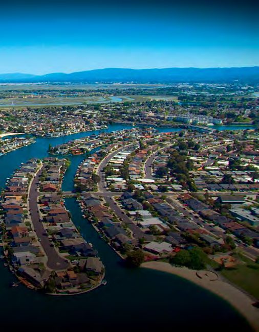
R E A DI NG T H E L A N D S CA PE   |   A F I EL D GU I DE

If you’re curious about what is here
and how it became this way, this
Field Guide can help you peel back
the layers of time. By looking
carefully for clues in the landscape,
you’ll understand how human
activity has long intertwined with
nature to create a hybrid landscape
around San Francisco Bay.
To get you started, we’ve told the stories of a few
areas around the bay, poking under the roadways
and parking lots of modern development to reveal
what’s beneath the surface. We’ve also assembled
a set of features to look for, and a list of online
sites that can give you more information.

                                                                          001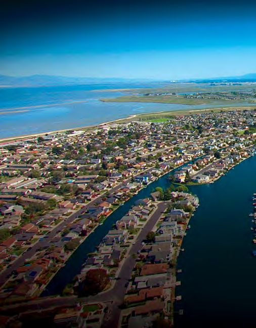
What to
      Look For
002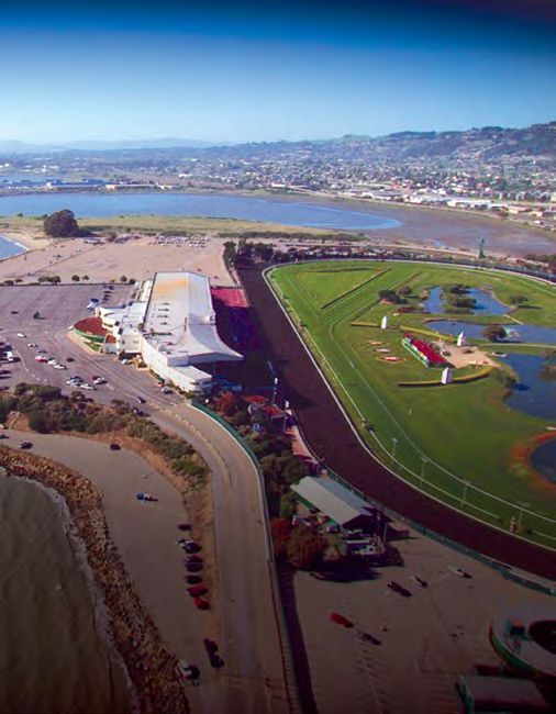
R E A DI NG T H E L A N D S CA PE   |   A F I EL D GU I DE

As you survey the shores in
and around the Bay Area...

Follow the water.

Observe the shape of the land.

Take an inventory of the plants.

Study the built environment.
opposite :   Berkeley Marina and Aquatic Park.                                                   003
opposite inset : Port of Oakland.
Follow the water.

O
          bserve where water flows and how
          it travels. This can tell you a lot about
          how we’ve shaped the landscape.
Water naturally flows in creeks down from the hills, across the flatter
plains and into the Bay. We’ve modified how water flows so that we can
collect it for drinking and irrigation, and to lessen the effects of flooding.
Some creeks have been covered over and channeled into pipes to provide
flood protection. Some of these are now being “daylighted,” or uncovered
and restored.

004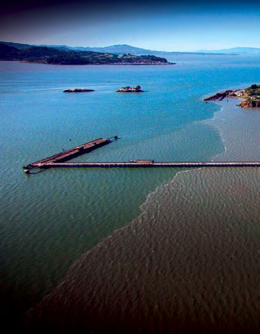
R E A DI NG T H E L A N D S CA PE    |   A F I EL D GU I DE

                                                 If you’re at the shoreline, look for
                                                 the effect of tides. High tide—
                                                 which can raise the Bay’s water
                                                 level as much as six feet—pushes
                                                 salty water up into the creeks and
                                                 sometimes floods the land.

The natural contours of Alameda Creek Slough.

If you’re walking along a creek,
look for signs that the structure
and path of the waterway has
been shaped by humans. Do you
see large rocks lining the edge of
a creek? Is the water flowing in                 Steps entering the Bay at low tide, Lucretia
                                                 Edwards Park, Richmond.
a gutter, ditch, or gully and into
a storm drain? Keep an eye out
for dams and mounds of earth
constraining the course of a creek.

opposite :
        Colma Creek lined with                                                                  005
flood control walls.
Observe the shape of the land.

B
        oth natural processes and human activity
        change the shape of the land, sometimes
        quite rapidly but also more slowly, over
longer time periods.
Natural forces of rain, flowing water, wind, plants, and animals cause
changes like erosion, landslides, earth flows, and sediment deposition.
Humans pave the landscape with roads, sidewalks, and parking lots.
People also fill in the Bay to create new land; contain the wetlands with
dikes; mine rock, salt, clay, and gravel; and level the land for farming
or infrastructure.

006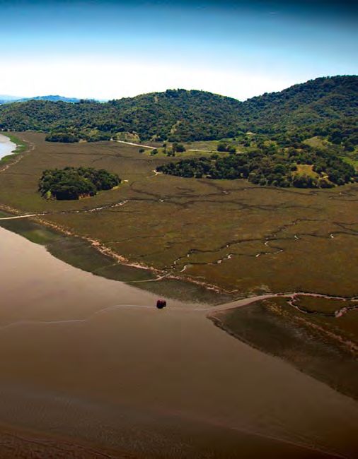
R E A DI NG T H E L A N D S CA PE   |   A F I EL D GU I DE

The natural topography of Coyote Hills at the      San Leandro Creek entering San Leandro Bay
Bay’s edge.                                        through a man-made canal near Martin Luther
                                                   King Jr. Regional Shoreline.

As you look at the landscape,
consider that its surface may
have changed over time. That flat
field may have formerly been a
hill. And the dry ground you’re
standing on may have once been
washed by the tides.

opposite :
        Paradise Cay yacht harbor, Tiburon, juts                                              007
out from the otherwise natural edge of the Bay.
Take an inventory of the plants.

O
        ver time, humans have changed the plant
        species that grow here. Learning about
        which plant species are native and which
are introduced can give you a deeper appreciation
for the area you live in. Look around—do any plants
seem out of place?
For thousands of years, the lowlands were composed mostly of native
grasses and wildflowers, dense patches of chaparral, and valley oak
savannas. Rushes, cattails, and sedges grew along rivers, freshwater
marshes, and wet meadows.

008
R E A DI NG T H E L A N D S CA PE | A F I EL D GU I DE
Salt tolerant plants, like pickleweed,
cordgrass, and saltgrass thrived
in tidal marshes.
Indigenous people actively managed
the vegetation of the Bay Area
through selective burning and other
practices that encouraged some
plants over others.
Non-native eucalyptus trees in McLaren Park.
Later, European and American
settlers introduced many new
plant species, like wild mustard,
desert cactus, and palm and
eucalyptus trees.
Together, these new plants and
people transformed the landscape
Native pickleweed in Napa. much more quickly.
opposite :
Non-native palm trees lining 009
San Francisco’s Embarcadero.Study the built environment.
H
umans have imposed a wide variety of
structures on the landscape. You can learn
about how people live in an environment
by looking at what is built on it, and how it all connects.
One way to understand infrastructure is to think about how we use the
things we build. We want to move easily through the landscape, so we
build roads, highways, bridges, mass transit systems, airports, railroad
tracks, trails, walkways, and bicycle paths. We’ve constructed houses,
apartments, and condos to live in.
010R E A DI NG T H E L A N D S CA PE | A F I EL D GU I DE
We work and shop in factories, Another way to see the built
office buildings, and retail stores. environment is to look for geometric
We’ve laid natural gas and shapes on the landscape. For
petroleum pipes and electrical example, straight lines and right
power lines to carry energy across angles are not often found in
and around the Bay. nature—they are usually created
by humans.
People pave straight roadways and
streets, divide property lines in
squares and rectangles, and plant
trees in a row. If the creek you’re
looking at runs in a straight line,
people have probably channeled
its flow. If a straight earthen wall
separates water from land,
it’s probably a human-made levee.
You can see the shapes and lines
from above—while traveling by
The diked maze of man-made salt ponds, plane, studying satellite images
South Bay.
and maps, or standing on a hill
looking at the landscape below.
opposite :
Runways of the San Francisco Airport, 011
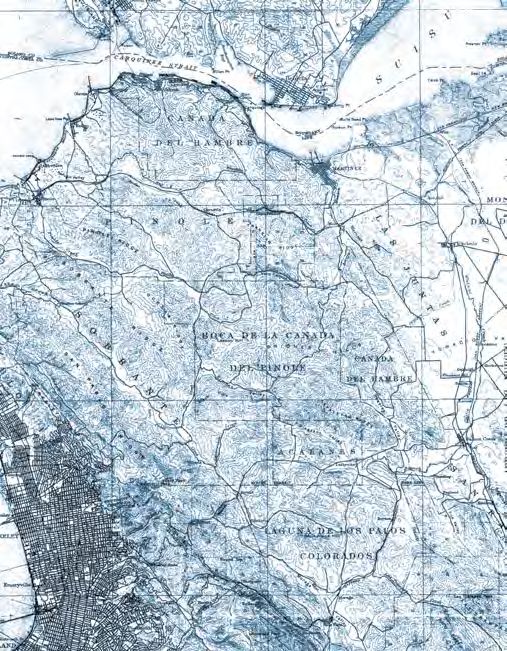
constructed on fill.Gold Rush
Legacy at
China Camp
012R E A DI NG T H E L A N D S CA PE | A F I EL D GU I DE
T
here was never any gold at China Camp.
But gold mining up in the Sierra foothills
changed the landscape here.
Beginning in the 1850s, miners in the Sierra Nevada Mountains used
a process known as “hydraulic mining” to blast mountainsides with jets
of water to unearth gold. The soil from those mountainsides washed
down rivers and creeks to the Bay. By 1885, 1.6 billion cubic yards of
sediment (enough to fill 500,000 Olympic-sized swimming pools or to
cover the entire city of San Francisco with a pile of dirt three stories tall)
had washed down to the Bay.
While this new sediment had many
negative impacts, it also created
new tidal marshes around the Bay,
including a “centennial” marsh at
China Camp. These new marshes,
a legacy of the Gold Rush, now
provide critical habitat for wildlife
like the endangered California
Clapper Rail.
Hydraulic mining in Nevada County, circa 1860s.
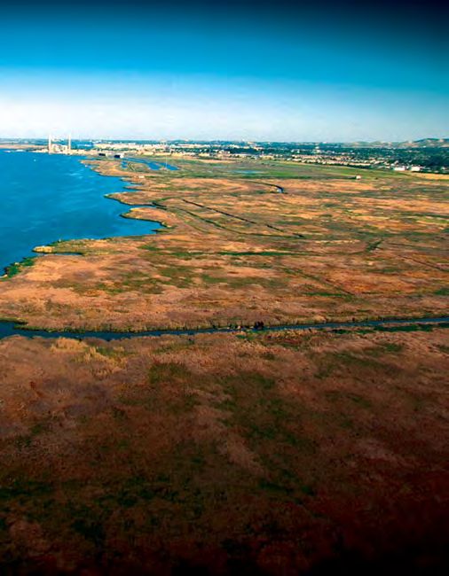
013What you’ll see.
Look for two different marshes: The original marsh at China Camp
an ancient tidal marsh and a is one of the largest ancient tidal
newer one created from Gold Rush marshes remaining in San Francisco
sediment. At China Camp you can Bay. It started to form about
tell where the ancient marsh ends 4,500 years ago when the rate of
and the young marsh begins by sea-level rise slowed enough for
looking at how straight or curvy marsh plants to take hold. You can
the channels are. identify the ancient marsh by its
sinuous (or curvy) channels.
Channels in the younger marsh—
formed from the rapid deposit of
Gold Rush sediment—are much
N straighter than those in the
EW
M ancient marsh. A newer section
OL A
D
M
R
SH of marsh, formed from Gold Rush
A sediment, is known as a “Centennial”
R
SH
marsh. Centennial marshes
are generally less complex than
ancient marshes.
The division between the original tidal marsh
and the centennial marsh.
014R E A DI NG T H E L A N D S CA PE | A F I EL D GU I DE
background: Detail of the channels curving through the marsh.
015Landfill of
Albany Bulb
016R E A DI NG T H E L A N D S CA PE | A F I EL D GU I DE
A
lbany Bulb is a local park that juts into the
Bay, providing excellent access to the water
and spectacular views of San Francisco.
The land is not original, but fabricated from discarded
construction material and other fill.
When the Golden Gate Fields racetrack—just to the south of the Bulb—
was created in 1939, part of the nearby shallow bay was filled in to
create parking lots. In the 1960s, building debris such as concrete, rebar,
and clay was dumped beyond this first fill, creating the shape of
Albany Bulb as we find it today. Dumping was halted in the 1980s.
Today the park provides for a
wide array of activities, including
dog-walking, bird-watching, and
viewing the scattered and ever-
changing art installations made
from remnant concrete and
driftwood. A homeless population
built shelters on one part of the
space. Future plans for the park
include turning the Bulb into part
of the Eastshore State Park.
Homeless encampment on Albany Bulb.
017What you’ll see.
Though it’s hard to believe that
the entire park is made of fill,
evidence of landfill is everywhere.
Look for broken concrete and
construction debris that lines the
edge where land meets water.
Known as riprap, this structure
stabilizes the land and protects
it from waves and tides. You can
see slabs of concrete poking out
from under a thin layer of clay;
spikes of rebar jutting into the air;
and walkways made from bricks Artists use the nearby riprap for their canvases.
and mortar. Native saltgrass and
invasive pampas grasses grow side
by side.
Landfill has created solid ground
in many places along the edge
of the Bay. On this map, the dark
blue is the historical marsh,
mudflat and open water, and the THE
BU LB
orange shows islands of land in
the mudflats. Black lines indicate
the original extent of the Bay.
Map of original shoreline around Albany Bulb.
018R E A DI NG T H E L A N D S CA PE | A F I EL D GU I DE
background: Riprap lines Albany’s shoreline from the racetrack to the Bulb.
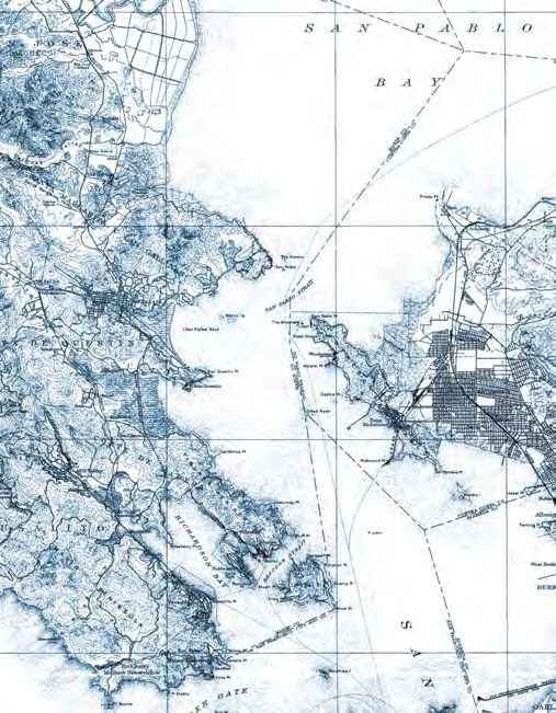
019Piers Reaching Into the Bay 020
R E A DI NG T H E L A N D S CA PE   |   A F I EL D GU I DE

B
               ecause the Bay is so shallow, people built long
               piers and wharves to reach the deep water
               of the Central Bay where ships could dock.
The Oakland Mole, originally constructed in the mid-1800s, extended
more than two miles into the Bay. A mole is different than a pier: it’s
made of stone or earth, and water can’t pass beneath it. The Oakland Mole
was built of dredged fill and topped with railroad tracks. After taking
the train to the end of the Oakland Mole, passengers boarded a ferry
for San Francisco.

                                                  The Berkeley Pier—at one point
                                                  3.4 miles long—extended from the
                                                  foot of University Avenue. First
                                                  built by the city of Berkeley in
                                                  1909, it had a long life connecting
                                                  goods and people with freight
                                                  ships and ferries. The ferries
                                                  stopped running in 1939 after the
                                                  Bay Bridge opened, and much of
                                                  the pier was left to decay.

The Oakland Mole once nearly reached as far as
Treasure Island.

                                                                                             021
What you’ll see.
Most of the Bay’s historical piers
were removed after the construction
of the Bay Bridge, but remnants
of the structures still exist.
Look for remnants of the Oakland
Mole in Middle Harbor Shoreline
Park in Oakland. This park sits at
the Bay end of the original Mole.
Although this small park juts only
a short distance into the waters
of the Bay today, the site was once
over a mile from shore. All the land
behind the park was filled after The remains of Berkeley Pier today.
1915 to create the Port of Oakland.
Old pilings from the Berkeley Pier
still extend almost all the way to
Treasure Island. You can see them
from the end of the modern-day
Berkeley Pier. A segment of the
original pier has been maintained
for pedestrians and fishing.
022R E A DI NG T H E L A N D S CA PE | A F I EL D GU I DE
background: Richmond pier, Richmond Point.
023Wetlands
Under a
Soccer Field
024R E A DI NG T H E L A N D S CA PE | A F I EL D GU I DE
A
lthough it’s now suitable for soccer players
of all ages, Raimondi Park in West
Oakland is actually a filled-in marsh.
Raimondi Park is a 10-acre park in West Oakland, providing much-
needed open space for barbecues, baseball, soccer, and other recreation.
It is also situated within a broad triangular wedge of what was once
a tidal marsh. This triangle remained stubbornly undeveloped until the
1880s. Early maps show the marsh’s channels and sloughs remained
as the surrounding area filled with houses and businesses. Eventually
the marsh was filled and the site became Bayview Park.
The current park was dedicated in
1947, and named in honor of Ernie
Raimondi, a minor league baseball
player who grew up in Oakland.
On this map the original shoreline
is indicated by a black line, and
the extent of the original marsh is
indicated in green.
Map of original marsh around Raimondi Park.
025What you’ll see.
Stand in the park facing the Bay—
150 years ago, you would have been
standing in a tidal marsh. Mudflats
and the open bay would stretch in
front of you. If the tide were at its
highest, your feet would be wet. Just
800 feet ahead—about where the
Ikea loading dock is—were small
sandy beaches. The Emeryville
shellmound—a sacred site to the
local Ohlone people—would be
visible a mile to the north.
For many years after the park was The soccer fields of Raimondi Park.
developed, you might have seen
Look at other low-lying areas
water collecting and ponding on
around the edge of the Bay. Tidal
the fields during the winter rainy
and seasonal flooding on yards,
season, a clue that this was once
fields, and roads is often an
a wetland. In 2007, the Oakland
indication that these are former
Tribune reported that the park’s
wetlands.
“drainage problems are so severe
that the fields are closed three
months of the year except to geese.”
In 2008, substantial refurbishment
included new drainage systems for
the playing fields.
026R E A DI NG T H E L A N D S CA PE | A F I EL D GU I DE
background:The original marsh may have looked like this one near Antioch
before Bay Fill created a space for Raimondi Park.
027Suburbs on
Top of
Tidal Marsh
028R E A DI NG T H E L A N D S CA PE | A F I EL D GU I DE
F
oster City, a suburban neighborhood
east of San Mateo, is one of the last places
around the Bay where housing was
constructed on marsh fill.
In 1898, rancher Frank Brewer built dikes and dried out the marsh
to grow hay for dairy cattle. In the 1940s, Leslie Salt Company built
evaporation ponds on part of the island. Real estate tycoon T. Jack Foster
dredged parts of the land in 1958 to create an artificial lagoon with
connecting waterways, pumping in 14 million cubic yards of sand.
Foster City is now home to 30,000 people.
Much of the Bay’s edge has been
FOSTER CITY
filled for agriculture and to provide
places to live and work. Two of the
first places filled were Yerba Buena
Cove and Mission Bay, made into
new city lots for booming San
Francisco in the mid-1800s. Some
other places around the Bay where
housing has been built on bay fill
include the Marina District in
San Francisco, Bay Farm Island
in Alameda, and Santa Venetia
in Marin County.
Aerial view of the man-made lagoons that
shape Foster City and the natural waterways
that surround it.
029What you’ll see.
Compare the wiggly shape of Seal
Slough to the Central Lagoon
of Foster City, which makes a
symmetrical arc through town.
Waterways engineered by humans
curve and twist much less than
those that are natural.
Notice how close the land lies to
the water. Foster City was built
just above sea level. During floods,
the city has to pump excess water
from the lagoon into the Bay.
Seal Slough snakes its way through San Mateo
before emptying into the Bay.
Natural and human-made waterways
have very different shapes. On the
west side of Foster City is Seal
Slough, a curvy and meandering
channel, which separates the suburb
from neighboring San Mateo. Seal
Slough is a large remnant channel
of the former marshes now beneath
Foster City.
030R E A DI NG T H E L A N D S CA PE | A F I EL D GU I DE
SOCCER FIELD
BACKGROUND (SFEI)
background: The man-made lagoons create symmetrical arches through Foster City
031Additional resources. H I S T OR ICA L E C OL O G Y San Francisco Estuary Institute sfei.org/he H I S T OR ICA L M A P S A N D I M AG E S US Geological Survey nationalmap.gov/historical/bard.wr.usgs.gov David Rumsey Map Collection davidrumsey.com Library of Congress loc.gov/index.html Online Archive of California oac.cdlib.org Calisphere, University of California calisphere.universityofcalifornia.edu N E W S PA P E R A R C H I V E S California Digital Newspaper Collection cdnc.ucr.edu/cgi-bin/cdnc CA L I F OR N I A H I S T OR ICA L C OL L E C T ION S California Historical Society californiahistoricalsociety.org Society of California Pioneers californiapioneers.org The Bancroft Library, UC Berkeley bancroft.berkeley.edu M USEUMS Oakland Museum of California museumca.org 032
R E A DI NG T H E L A N D S CA PE                    |   A F I EL D GU I DE

Image credits.
 background map, front cover and interior spreads: “San Francisco”             1873, Courtesy of the California History Room, California
 (Topography, 15’ quadrangle), U.S. Geological Survey, 1899,                    State Library, Sacramento, California.       page   14: China Camp
 Courtesy U.S. Geological Survey.             reference map, left inside        marsh map overlay, Image Courtesy of SFEI.               page   12/15
cover:   “San Francisco Bay,” Courtesy of Marnie B. Karger,                     background/front cover:       China Camp marsh, CLUI, 2013,
 2013.   page   2/back   cover:   Berkeley Marina and Aquatic Park,             Museum Commission page 17: “Hobocamp #3,” Orin Zebest/
 Center for Land Use Interpretation (CLUI), 2013, Museum                        Flickr, 2007, Courtesy of the artist. page 18, top: “One-Albany
 Commission.      inset:   Port of Oakland, CLUI, 2013, Museum                  Bulb (HDR),” Ben De Jesus/Flickr, 2010, Courtesy of the artist.
 Commission.      page   4: “Views of Colma Creek,” Nicole David,               bottom: Albany Bulb map overlay, Image Courtesy of SFEI. page

 Pulse of the Estuary, 2010, Courtesy of the San Francisco                     16/19   background:     Albany shoreline, CLUI, 2013, Museum
 Estuary Institute (SFEI). page 5, left: “Alameda Creek Slough,”                Commission. page 21: Foster City, Seal Slough (detail), National
 Charlie Day/Flickr, 2013, Courtesy of the artist. right: Lucretia             Agriculture Imagery Program (NAIP) of the U.S. Department
 Edwards Park, Micha Salomon, 2013, Courtesy of SFEI. page 6/                   of Agriculture (USDA), 2009, Image Courtesy of SFEI. page 22:
 front cover:   Paradise Cay yacht harbor, Tiburon, CLUI, 2013,                “Seal Slough,” King of Hearts/Wikimedia, 2011, Courtesy of
 Museum Commission.           page   7,   left:   “Coyote Hills Regional        the artist.   page   20/23   background/front cover:    Foster City,
 Park,” Marcel Marchon/Flickr, 2008, Courtesy of the artist.                    CLUI, 2013, Museum Commission.            page   25: Raimondi Park
 right: San Leandro Creek, Image Courtesy of SFEI. page 8: “The                 soccer field, Robin Grossinger, 2012, Courtesy of SFEI.          page

 Embarcadero, San Francisco,” MD111/Flickr, 2007, Courtesy                      26: Raimondi Park soccer field, Robin Grossinger, 2012, Image
of the artist. page 9, left: Pickleweed in Napa River tidal marsh,              Courtesy of SFEI. page 24/27 background: Marsh near Antioch,
 Susan Schwartzenberg, 2009, Courtesy of the artist.                  right:    CLUI, 2013, Museum Commission.            page   29: “San Francisco”
“Trees, McLaren Park, San Francisco,” Ed Brownson/Flickr,                       (Topography, 15’ quadrangle), U.S. Geological Survey, 1899,
 2012, Courtesy of the artist.        page   10: San Francisco Airport,         Courtesy U.S. Geological Survey.          page   30: “Broken Pier,”
 CLUI, 2013, Museum Commission.                   page   11: South Bay Salt     Dannebrog/Flickr, 2007, Courtesy of the artist.          page   28/31
 Ponds, CLUI, 2013, Museum Commission. page 13: “Hydraulic                      background:    Richmond pier, Richmond Point, CLUI, 2013,
 mining near French Corral, Piping the Bank, (near view)                        Museum Commission.
 Nevada County. #1404,” stereo card (reproduction), 1867–

Thank you.
This field guide was produced by the Oakland Museum of California in partnership with the
San Francisco Estuary Institute (SFEI): Ruth Askevold, Robin Grossinger, Sam Safran,
and Micha Salomon. With special thanks to the Center for Land Use Interpretation (CLUI).
This guide invites you to see San Francisco Bay
in a new way. Layers of urban history here rest on
an older landscape of grasslands, woodlands,
marshes, and tidal f lats. Given the challenges of
climate change and sea level rise, it’s a good time
to discover how the past shapes the future.
You can also read