Disc * - Design & Innovation for Sustainable Cities College of Environmental Design University of California - Berkeley Summer Session 2017 ...
←
→
Page content transcription
If your browser does not render page correctly, please read the page content below
Design & Innovation for Sustainable Cities
College of Environmental Design
University of California - Berkeley
Summer Session 2017
ENV DES 8/98
Gabriel Kaprielian
Agostino DiTommaso

  Disc *
                                             2017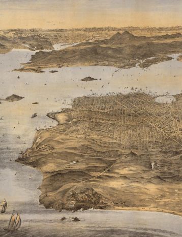
Disc* 2017 2
fieldwork + site visits*
                         Field Trip 1 | Bay Area Region | July 5th
                         Exploratorium Fisher Bay Observatory – Bay Model – Mt. Tamalpais

                          Our first field trip will focus on the dynamic interplay between the built
                         and natural environments of the Bay Area. You will learn about the
                         historical transformations that have shaped the region into the place
                         that you see today. We will begin at the top of Mt. Tamalpais, one of the
                         highest peaks in the area, which offers a panoramic view of the entire
                         San Francisco Bay and surrounding cities. We will be joined by LEAP
                         founder Nathaniel Kaufmann and Wildlife Biologist Lidia D’Amico as they
                         led an interpretive tour. Next, we will visit the Bay Model in Sausalito,
                         constructed by the U.S. Army Corps of Engineers as a working hydraulic
                         scale model of the San Francisco Bay. A Park Ranger will guide us through
                         the exhibit and talk about the pivotal history of the model’s construction
                         and the Save the Bay movement. We will then travel via ferry to the
                         Exploratorium’s Fisher Bay Observatory in San Francisco where we will be
                         joined by Senior Artist and Curator Susan Schwartzenberg to explore the
                         scientific exhibits and maps that allow us to understand the functioning of
                         the Bay ecology and urban morphology of San Francisco.

                         Fieldwork 2 | Walkabout | July 12th
                         Eastern San Francisco Waterfront - Heron’s Head Park

                          Alison Sant will lead this exploration of San Francisco’s Eastern
                         Waterfront. This area, on the verge of massive transformation, represents
                         more than any other in the city the complexity and contradiction that
                         characterize contemporary urban process. Remnants of its industrial
                         past and long-time residential communities here coexist with the first
                         outcomes of a series of interventions that will reshape the urban form and
                         the ecology of the area in radical ways. Throughout the walk we will have
                         a chance to meet with many professionals that are leading cutting-edge
                         work in this interesting site. We will hear from Carol Bach from the Port
                         of San Francisco, Noreen Weeden from the Audubon Society, Catherine
                         Boyer from the Romberg Tiburon Center for Environmental Studies, and
                         Jeremy Lowe from the San Francisco Estuary Institute about experimental
                         practices for climate change mitigation. We will talk with Philip Vitale from
                         the Trust of Public Land about the future of green public space planned
                         for the site. Finally, we will discuss with John Bela from Gehl Studio about
                         the ambitious projects for new development that are currently underway.

Disc* 2017 - Fieldwork                                                                                   3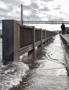
Disc* 2017 - Fieldwork 4
seminars*
                        Urban Innovation Seminar | Gabriel Kaprielian & Ghigo DiTommaso

                        The Urban Innovation Seminar provides a framework for discussing and
                        contextualizing student work. Every week, students will engage in lively
                        discussions ignited by brief presentations delivered by the Program Directors.
                        To prepare for each session, students will be assigned readings and writings on
                        the selected topics. The Urban Innovation Seminar will be presented in three
                        modules: Urban Place, Urban Form, and Urban Futures.

                        Urban Place will focus on understanding the transformations of the built
                        and natural environment of cities and how this can be used to inform
                        future design decisions. Topics will include the use of mapping to geo-
                        reference and layer past, present, and potential future urban and natural
                        conditions to develop a narrative of place.

                        Urban Form will explore precedents of city block and housing typologies
                        around the world and the factors and urban theory that shaped it.
                        Examples will include built urban form from various time periods and the
                        speculative urban form proposals and theory that in uenced it.

                        Urban Futures looks at the continually evolving nature of cities,
                        which are ever changing based on economic, social, environmental,
                        and technological factors. Topics will include smart cities, big data,
                        autonomous driving vehicles, ecoblocks, sustainability initiatives,
                        resilience cities, and the role of science fiction and speculative design.

                        Global Cities / Global Challenges Seminar | Ghigo DiTommaso

                        The Global Cities/Global Challenges Seminar addresses some of the most
                        pressing challenges global cities are facing today. Through a series of lectures
                        on the past, present and future of urban regions across five continents, we will
                        discuss the many wicked problems cities are tackling. The seminar will also
                        expose students to a series of success stores, showing how things can really
                        change for the better through the agency of environmental design.

Disc* 2017 - Seminars                                                                               5
digital workshops*
GIS Workshops | 11th and 13th
Katie McKnight – Digital Lead GIS
The GIS workshops will cover the basics of digital Geographic Information
System mapping and will directly support the studio project work. The
GIS Workshops will include geo-referencing historic maps, creating
thematic maps, and visualizing data geospatially. There will focus on
topics that will assist you in creating a past, present, future narrative
of your assigned team site. You will use historic maps to understand
the urban morphology and historic ecology, while layering current and
projected future maps to see areas of intersection and transformation.
Additionally, you will create scaled base maps to use as reference during
your site Fieldwork. Lastly, you will explore higher level mapping functions
such as 3D visualization with ArcScene, while paying particular attention
to mapping as an art to achieve compelling and informative graphics.
Rhino Workshops | July 20th, July 25th
GSI Instructors
The Rhino workshops will demonstrate digital 3D modeling and 2D
drafting techniques, rendering with the VRay plug-in, graphic exporting,
and digital fabrication file processing. Topics in the workshops will directly
support the studio project work. The Rhino Workshops will focus on
digital modeling and drafting to develop your urban design scenarios, in
addition to exporting 2D graphics for Adobe software and presentations
and creating perspective renderings with VRay.
Disc* 2017 - Workshops 6Adobe Workshop | July 21st
GSI Instructors
The Adobe workshop will include instruction with Photoshop, Illustrator,
and InDesign. The workshop will link the workflow from Rhino 2D
graphic exports, digital rendering, and generally focus creating high
quality presentation materials from design work. Photoshop will include
instruction on rendering techniques. Illustrator will be used primarily to
create 2D vector graphics. InDesign will be used for Presentation Board
layouts.
Digital Fabrication Workshop | July 25th
GSI Instructors
The Digital Fabrication workshop will demonstrate techniques for additive
and subtractive manufacturing. You will use Rhino software to create 2D
and 3D files for fabrication of parts for your game board. This includes
the use of 3D printing and lasercutting. In this process, you will learn to
materialize your digital designs into physical artifacts.
Disc* 2017 - Workshops 7studio syllabus*
“We need to view the fragility of the planet and its resources as an
opportunity for speculative design innovations rather than as a form for
technical legitimation for promoting conventional solutions. By extension,
the problems confronting our cities and regions would then become
opportunities to define a new approach.”
- Mohsen Mostafavi, Ecological Urbanism
Studio Goals
Learn theory and skills to analyze a complex urban environment, assess
need through research and mapping, develop an informed design
proposal, and create effective representation utilizing computer software
and digital fabrication methods.
Studio Overview
Through mapping, research, and design you will envision the future of
the San Francisco Bay Area’s urban waterfront as a model for resilient
urban design and adaptation in the face of sea level rise. You will use
the Bay Area as a living laboratory for research and speculative design
interventions. The studio project will build off of the Resilient By Design
Bay Area Challenge, an interdisciplinary competition which aims to
develop implementable designs for coastal resilience in Bay Area
communities. You will investigate and illustrate various scenarios to
address issues of sea level rise, infrastructure, housing, social inequity,
and livability, etc. To accomplish this task, you will work at multiple
scales (Regional + City + Neighborhood + Human) to understand the
interconnection and complexity of the urban fabric and local ecology.
Working in teams, you will focus on a given site context in San Francisco
Bay Area. Utilizing the framework of a gameboard your team will
investigate the built and natural environment, various stakeholders, and
adaptation scenarios that result in speculative designs for an innovative
new urban form. The final design and research will be represented both
physically with a digitally fabricated gameboard model and graphically
with presentation boards and a final program book. Each of you will be
a contributor to the content of this work and making DISC 2017 a success!
Disc* 2017 - Syllabus 8Studio Project – Adapting to Rising Tides in the San Francisco Bay Area
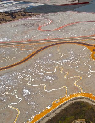
The waterfront along the San Francisco Bay is facing a growing threat
from sea-level rise. Over the years, the Bay Area has seen a large portion
of the historic wetlands filled or leveed off for residential, commercial,
and industrial land uses. With current sea-level rise projections, it appears
that the water will once again reclaim the bay lands that have been filled.
By the end of the century, a projected sea-level rise of 140cm may affect
an estimated 270,000 people in the Bay Area and 331 sq. kilometers of
urban development valued at $62 billion. To further complicate matters,
it is estimated that 2.1 million people and 660,000 homes are expected
to arrive by 2040, adding to the 7 million current Bay Area residents.
In addition to the built environment, sea-level rise will also affect the
ecology of the San Francisco Bay, threatening to submerge the majority
of existing tidal wetlands by mid-century.
The issues presented by sea level rise along the urban edge of the San
Francisco Bay involve a complex series of challenges. This includes
regional vs. local governance, built vs. natural environment, vulnerable
shared infrastructure, diverse stakeholders, population growth, etc.
With each chance scenario and potential design solution, there may be
multiple outcomes with winners and losers, resembling a gameboard.
How can the best design or policy be selected and tested? How will
distinct communities learn about different options and strategies for
coastal adaptation and be empowered to act? By creating and playing
a sea level rise adaptation “game” of your own design, you will explore
different scenarios to inform future urban planning decisions.
While climate change and sea level rise have are often seen as a
problem, we will instead view them as an opportunity for design
innovation to create more resilient and sustainable cities. Design of the
built environment is inherently an optimistic pursuit, and as such we will
explore the transformative potential of visualizing speculative futures. By
reframing sea level rise as an opportunity, we will explore design solutions
that move beyond mitigation strategies using the same old toolbox and
rather use climate change as the motivation to focus on innovative design
solutions that adapt to the needs of a 21st century city.
Through mapping, research, and design the focus of our studio work
will be to envision the future of San Francisco Bay Area’s urbanized
shoreline as a model for resilient and adaptable urban design. Each of
the sites has been chosen for their distinct characteristics, challenges,
and opportunities for growth and redesign. You will be tasked with
exploring different scenarios of coastal adaptation and innovative urban
design solutions. By researching the built and natural environment past,
present, and future you will gain an understanding of the constraints and
opportunities for informed design decisions. Using the framework of a
game board, you will investigate the various stakeholders and explore
different adaptation strategies and potential outcomes for coastal
resilience.
Disc* 2017 - Syllabus 9Disc* 2017 - Syllabus 10
Studio Deliverables

                        You will be conducting research and design work on a weekly basis,
                        individually and in teams. This work will build towards the final studio
                        deliverables described below:

                            •   Gameboard – The gameboard will represent the culmination of
                                research, mapping, and design strategies for your team’s assigned
                                site. You will use the gameboard to investigate the potential
                                outcomes of different scenarios and the relationship between
                                adaptation strategies and the various stakeholders. The final result
                                will be a layering of maps and site analysis with game pieces and
                                instructions for play. The game board will utilize a variety of digital
                                fabrication methods to construct the final product, including
                                subtractive and additive manufacturing. The result should be
                                a hybridized work of research, mapping, and design that is an
                                interactive game and artistic artifact.
                            •   Presentation Boards – The final presentation boards will display
                                the research and design efforts of your team graphically. This
                                will include the visualizations of different planning strategies and
                                scenarios. You will be given specific guidelines for content that will
                                include such graphics as a master plan, site and street sections,
                                perspective renderings, etc. You will be expected to illustrate
                                potential designs with visually compelling and clear graphics,
                                combined together in a professional format.
                            •   DISC 2017 Book – The DISC book will serve as a final archive
                                of the studio work. The book will be compilation of the design
                                process and final work, in addition to other DISC program content.

                        Weekly Overview

                        Week One: Bay Area / Region
                           • Bay Area Presentation
                           • Fieldwork #1 – Bay Area
                           • Research + Mapping

                        Week Two: Site Mapping / City
                           • Home City Presentation + Mapping Review
                           • Fieldwork #2 – Walkabout
                           • Research + Mapping
                           • Site Analysis Past, Present, Future

                        Week Three: Game board / Human
                           • Mid Review Presentation
                           • Field Trip #3 – Site Visits
                           • Game Development + Representation
                           • Stakeholders, Strategies, and Scenarios

                        Week Four: Design Production
                           • Final Review Mockup Presentation
                           • Digital Fabrication Models of Gameboard
                           • Presentation Boards
Disc* 2017 - Syllabus                                                                                     11
Week Five: Presentation
• Final Review Presentation + Public Exhibition
• Presentation Refinement
• Finalize Work and Prepare for Display
• Work Documentation + Portfolio and Studio Book
Week One: Bay Area / Region
Bay Area Research + Mapping
“… maps give us reality, a reality that exceeds our reach, our vision, the
span of our days, a reality that we achieve in no other way.”
- Dennis Woods, “The Power of Maps”
Learning Objectives
Gain a greater understanding of San Francisco city in the context of the
Bay Area region through research, mapping, and first-person observation.
Week One Overview
You will begin with a first-person observation of the Bay Area during
our Field Trip #1 that will include a visit to Fisher Bay Observatory in the
Exploratorium, the Bay Model, and Mt. Tamalpais. Joining us will be
expert professionals who will interpret and explain the urban and natural
transformations of the Bay Area.
You will continue your analysis of the Bay Area through mapping and
research. Working in teams, you will explore the past, present, and future
built and natural environment at the scale of the region.
Utilizing Internet databases and library resources at UC Berkeley, you will
compile information, written descriptions, and images that will combine
with your mapping to create a narrative of the Bay Area. In teams, you
will create a presentation with (20) slides that are visually compelling and
informative.
Each team will be assigned a specific area of focus that will serve as a
combined studio resource throughout the program. Teams will conduct
research into their assigned focus area.
Specific areas of focus:
• Historical Ecology (wetlands, flora, fauna)
• Indigenous History + Culture
• Coastal Transformations (bay fill, sea-level rise, levees)
• Urban Morphology historical development and future planning)
• Infrastructure (water, waste, energy)
• Demographics (race, income, social equity, gentrification)
• Transportation (roads, rails, ferries, bicycle routes, bus)
• Land Use (built land, open space, parks, public space)
• Policy (law and land use)
Disc* 2017 - Syllabus 12Week Two: Site Mapping / City
Site Analysis + Mapping
“Mapping is a fantastic cultural project, creating and building the world
as much as measuring and describing it.”
- James Corner, “The Agency of Mapping: Speculation, Critique
and Invention”
Learning Objectives
Utilize mapping techniques in combination with research and fieldwork
to gain a greater understanding of your assigned city site in the
context of Bay Area. Develop a narrative of the urban transformations,
historical ecology, current built and natural environment, demographics,
and potential future sea level rise scenarios that can inform a coastal
adaptation planning.
Weekly Overview
During the second week, we will take a closer look at cities and
neighborhoods. We will explore city form that has been built around the
world, including your own hometowns. We will attempt to understand
why cities are built the way they are based on a variety of factors including
environmental, economic, and cultural. In particular, we will focus on your
assigned cities and the neighborhoods where our studio project sites are
located.
We will begin with extensive mapping to understand the urban
morphology and underlying historic ecology of your sites. Through
mapping, we can investigate the past, present, and future context of our
sites and their relationship to the Bay Area region as a whole. Mapping
will allow us to geo-reference historic maps that layer on top of the
present built and natural environment to create a place narrative and
show how the city has been shaped over time. We can see what lies
underneath the city streets and explore the site ecology that existed
before and what remains today. Layering current maps of the city, we can
see the intersection of infrastructure, housing density, demographics,
and transportation to gain a more informed perspective for urban design
solutions.
In combination with site mapping, you will work in teams conducting
research on strategies for coastal adaptation and armament typologies
to combat flooding from sea level rise. This will include exploring case
studies of other city plans. As part of the research, Fieldwork #2 will be a
walkabout in the Southeastern waterfront of San Francisco where you will
learn from professional experts on site-specific work along the Bay. By the
end of the week, your team should have compiled work with mapping
and research that creates a compelling place narrative and potential
waterfront adaptation strategies.
Disc* 2017 - Syllabus 13Week Three: Gameboard / Human
Game Development
“Most of our housing and city planning has been handicapped because
those who have undertaken the work have had no clear notion of the
social function of the city.”
- Lewis Mumford, “What Is a City?”
Learning Objectives
Design a gameboard to play out various adaptation strategies for coastal
resilience that responds to the Resilient By Design Bay Area Challenge
and is informed by previous site mapping and case study research.
Define the stakeholders, scenarios, and instructions of play to investigate
potential outcomes. Create effective and compelling representation of
your work for graphic presentation and prepare files for digital fabrication.
Weekly Overview
Building off of the mapping, research, and fieldwork in week two, you will
further investigate your site by designing a game board and instructions
to test various adaptation strategies and events to determine scenarios
and their outcomes, which affect stakeholders. The previous site mapping
will serve as the literal base and basis for your game design as it begins
to take on three-dimensional form through rough physical hand modeling
and digital modeling with Rhino software.
Following the Resilient By Design Bay Area Challenge, you will explore
different adaptation strategies in response to sea level rise and objectives
for coastal resilience and community sustainability. This will incorporate
addressing factors of housing, infrastructure, transportation, social
inequity, climate change, and livability, etc. You will determine the
stakeholders involved in your site, which may include homeowners, local
government, distinct demographic groups, natural vs. built environment,
etc.
Ultimately, you will develop a game board to explore different scenarios
the site factors, events, and strategies. This will involve defining resilience
and sustainability objectives that respond to sea level rise flooding,
coastal armament, protecting tidal wetlands and Bay ecology, meeting
housing demands of a growing population, and creating a more livable
and equitable community. Many of these objectives may be at odds with
each other. You will explore different outcomes by designing and then
“playing” your game board. Ultimately, you will illustrate the different
adaptation scenarios and determine the best design proposals. The
urban designs should reflect the relationship of your site to the Bay Area
region, when considering interconnected elements such as infrastructure,
ecology, and the social function of the city at the human scale.
Digital workshops with Rhino 3D modeling software and Adobe Creative
Disc* 2017 - Syllabus 14Disc* 2017 - Syllabus 15
Suite are aimed at building your skills in order to design and represent
                        your ideas effectively. Specific design production guidelines will be given
                        to assist in developing a clear, comprehensive, and professional final
                        output. This will include presentation boards with outlined deliverables
                        such as a master plan, site sections, perspective renderings, diagrams,
                        etc. Additionally, you will begin to develop files for digital fabrication of
                        your game board in week four.

                        Week Four: Design Production
                        Digital Fabrication + Representation

                        “Construction is the art of making a meaningful whole out of many
                        parts. Buildings are witnesses to the human ability to construct concrete
                        things.”

                                - Peter Zumthor, “Thinking Architecture”

                        Learning Objectives

                        Produce effective and compelling two-dimensional graphic
                        representation and three-dimensional models of your design proposals.
                        Utilize advanced computer software and digital fabrication machines to
                        create inspiring work that meets the studio deliverables.

                        Weekly Overview

                        Week four will focus on the production of your game board and urban
                        design proposals. During this week, you will have full access to the
                        Digital Fabrication Lab to create rapid prototypes and your final Game
                        Board model. This will include using the 3D printers and lasercutters.
                        Additionally, you will refine your design scenarios and the two-
                        dimensional graphic representation for your presentation boards.

                        You will receive an orientation on how to use the equipment in the
                        Digital Fabrication Lab, in addition to instruction on how to create cut
                        and print files in preparation for digital fabrication. A Digital Fabrication
                        workshop will demonstrate techniques of file preparation for additive and
                        subtractive manufacturing.

                        Week Five: Presentation
                        Refinement + Exhibition

                        “The timeless task of architecture is to create embodied existential
                        metaphors that concretize and structure man’s being in the world.
                        Images of architecture reflect and externalize ideas and images of
                        life; architecture materializes our images of idea life. Buildings and
                        towns enable us to structure, understand and remember who we are.
                        Architecture enables us to place ourselves in the continuum of culture.”

                                - Juhani Pallasmaa, “An Architecture of the Seven Senses”

Disc* 2017 - Syllabus                                                                                   16
Learning Objectives
Refine and produce final representative work of design scenarios, research,
and game boards for public presentation. Documentation of work for
archiving.
Weekly Overview
During the final week of the program, the focus will be on finalizing work
for public presentation and documentation. You will present your final work
both at UC Berkeley and in San Francisco to the public and invited guests.
This is your opportunity to demonstrate what you have learned and to also
be part of the continuing discourse in planning the future of San Francisco
Bay Area.
By week five, the bulk of the work should be done and you will be tasked
with refining graphic content for the presentation. This will require working
effectively as a team to finish work in a timely and professional manner.
You will need to practice the oral presentation as a team, developing a
narrative that describes the final proposals, design process, and research.
In addition to the exhibition and presentation of final work, we will also be
documenting work for the DISC book and your portfolio.
Disc* 2017 - Syllabus 17Disc * College of Environmental Design University of California - Berkeley July 5 - Aug 5, 2016
You can also read