Harnessing Floodwater of Hill Torrents for Improved Spate Irrigation System Using Geo-Informatics Approach
←
→
Page content transcription
If your browser does not render page correctly, please read the page content below
Research Journal of Recent Sciences _________________________________________________ ISSN 2277-2502
               Vol. 3(1), 14-22, January (2014)                                                      Res.J.Recent Sci.

      Harnessing Floodwater of Hill Torrents for Improved Spate Irrigation
                    System Using Geo-Informatics Approach
           Faisal Nadeem Saher1, Nasly M.A.1, Tuty Asmawaty Binti Abdul Kadir2, Nasehir Khan E.M. Yahaya3,
                                             Wan Mohd Faizal Wan Ishak4
                             1
                               Civil Engineering and Earth Resources, University Malaysia Pahang, MALAYSIA,
                          2
                           Computer System and Software Engineering, University Malaysia Pahang, MALAYSIA
                                3
                                  Department of Irrigation and Drainage Malaysia, Kuala Lumpur, MALAYSIA
                     4
                       Centre for Earth Resources Research and Management, University Malaysia Pahang, MALAYSIA
                                          Available online at: www.isca.in, www.isca.me
                                  Received 3rd May 2013, revised 12th June 2013, accepted 5th July 2013
   Abstract
   In semi-arid regions, sustainability of agricultural system is most demanding in view of economical approaches for
   agricultural water management and its ensured availability. Flood flows of hill torrents have potential prospects for
   development to meet growing demands of water for agriculture. However to harvest this potential through traditional
   systems is not a success story. This paper discusses GIS and Remote Sensing tools application as a strategy to explore viable
   and economical prospective of floodwater management for spate irrigation. The fundamental problem is the optimal
   conservation of hill torrents flows and management of these water resources. To tackle this problem, a study for reservoir
   site selection was carried out. In this study, we present cost effective approach to mitigate the flood hazard while conserving
   this floodwater as irrigated water supply to minimize drought threats for a spate irrigation system. The novelty of study is
   development of a methodology for estimation of water holding capacity for reservoir by using geo-informatics tools. The
   objectives of paper are i. to demarcate the potential catchments of spate irrigation system and ii. floodwater storage by siting
   reservoir with geo-informatics tools. As an auxiliary output, a geo database is generated for intend to use its attribute data
   and spatial data for future research projects. This geo database include data layers of satellite imagery, GPS aided ground
   control points, irrigation network, catchments, administrative boundaries, proposed reservoir site location and digitized
   linear and polygon features. The results of this study depict that agricultural water management would be carried out
   efficiently with the use of developed methodology. The reliability of proposed reservoir solution is higher due to the use of
   high resolution datasets.
   Keywords: Hill torrents, flood water management, spate irrigation, Remote Sensing, GIS.

Introduction                                                          then conveyed by distribution canals to the series of fields8.
                                                                      Flood flows of hill torrents have potential prospects for
Sustainable irrigated agriculture is dependent on cost effective      development to meet growing demands of water for agriculture
approaches to conserve the water resources1 whereas spate             in Pakistan9. In fact, these hill torrents have a lot of potential for
irrigation systems are considered as risk-prone2. Risk in the         agricultural development, if managed wisely. To harvest this
semi-arid regions is due to long periods of drought and               potential through traditional system of floodwater diversion
undedicated variability in rainfall runoff and distribution3. In      through earthen bunds is not reliable10. Moreover, the total crop
Pakistan, spate irrigation is carried out on 1.4 M ha (10 % of        water requirement is more than double than annual rainfall, it is
canal irrigated area) and is the largest system of world4. This       obvious that to secure agricultural productivity secondary
information leads to investigate sustainable managing practices       source of irrigation is needed11. It is, therefore essentially
for areas of spate irrigation by using more sophisticated             paramount to conduct research for the improvement of
approach through GIS.                                                 traditional system and to develop the sustainable system for the
                                                                      use this water potential as irrigation. This paper discusses GIS
Spate irrigation is associated with water management of               and Remote Sensing tools application as a strategy to explore
mountainous catchments (hill torrents) in arid regions5. This         this kind of prospective for study of floodwater management for
system is a reliable form of water harvesting systems6 but it         spate irrigation, and to evade the possible hazards caused by
differs significantly from controlled surface and groundwater         these floods.
irrigation systems. Variability of flows in space and time is the
salient feature of spate irrigation and predictability of flows is    The problem of the area is that these hill torrents bring in flashy
difficult, as floodwater comes from large size catchments             floods of shorter duration and high peaks12. Due to steep
located in Pakistan7. In the lowlands, the floods are diverted to     gradients, hill torrent flood flows with high velocities, which
adjacent irrigable lands by means of diversion structures and         result in damages to standing crops, irrigation system, and

 International Science Congress Association                                                                                            14
Research Journal of Recent Sciences ______________________________________________________________ ISSN 2277-2502
Vol. 3(1), 14-22, January (2014)                                                                  Res. J. Recent Sci.

infrastructure13. The fundamental problem is the optimal
conservation of hill torrents flows i.e. the management of water
resources of these hill torrents9. The spate irrigation system has
been functioning quite satisfactorily for a longer period of time
in study area of D.G. Khan but in recent past, due to
accumulation of sediments in irrigation channels5 caused
uneven distribution of water in the main channels and created
serious problem for overall management of the system. Due to
silt deposit, the capacity of the spate water channels has reduced
and cannot carry the excessive flood discharges and water
overspill the banks which causes the loss of water and also
prove damaging source for the crops. Current scenario indicates
that there is dire need to update and improve GIS based datasets
at the command area and field levels which is very crucial for
sustainable crop production system. Therefore, to tackle the
problem a detailed study for reservoir site selection is carried
out.
In this study, we present cost effective approach to mitigate the
flood hazard while conserving this floodwater to provide as
irrigated water supply to minimize drought threats for a spate
irrigation system. The novelty of study is development of a
methodology for estimation of reservoir water holding capacity
by using geo-informatics tools. The objectives of paper are i. to
demarcate the potential catchments of spate irrigation system
and ii. floodwater storage by proposing reservoir with GIS
based estimation of storage capacity. As an auxiliary output a
geo-database is generated for intend to use attribute and spatial
data for future planning for development projects. This geo-
database include data layers of satellite imagery, GPS ground
control points, irrigation network, catchments, administrative
boundaries, proposed reservoir site location and digitized linear
and polygon features.                                                                          Figure-1
                                                                      Defining study area at regional level using visual aid in 3D
Material and Methods                                                                           module

Study area: The extent of study area is mainly divided into two      A study in the arid mountainous region to explore the spate
levels i. regional local and ii. local level. The reason to adopt    irrigation potential has been conducted earlier16. However, this
this strategy was to control the budget of study by using            study was mainly based on field surveys and mapping details.
optimized financial resources to determine the cost effective        The value addition of current research study is that it is based on
methodology.                                                         both the use of mapping details and geo-informatics tools.

Regional level study area: Study area at regional level consists     Study area at local level: The spate irrigation is directly linked
of 115,230 km2 covering four provinces of Punjab, Sindh,             with hill torrents. The Vehowa hill torrent in D.G. Khan has
Baluchistan and Khyber Pakhtun Khwa (KPK) of Pakistan. The           2634 km2 catchment area with average discharge of 85,000
selection was done through dynamic visual aid of Digital             cusec and the command area is 122 km2 (figure 2). This hill
Elevation Model (DEM) at 3D module of global mapper                  torrent has caused losses of Rs. 45 million, Rs. 130.6 million
software application (figure 1). Further for precise demarcation     and Rs. 150.30 million during floods season of 1973, 1975 and
under natural boundary conditions this area was delineated           197617. It would be considered that that if these floods were
using basin tool in Arc GIS. To find runoff accumulation, the        controlled at upper catchment, the amount of damage would be
hilly area was divided into sub-catchments using a digital           lesser.
elevation model and a GIS14. As the study area is not confined
of any administrative boundary, instead it is defined by the         The climate of the Vehowa is extremely hot and dry18 with an
mountainous catchment area. It has potential for spate irrigation    average annual rainfall of 300 mm. The temperature, humidity,
development as spate water coming from uphill have dissolved         evaporation and rainfall during the critical period from January
nutrients15 and it would be assume that more agricultural yield      to June are shown in (figure 3).
will be available.

International Science Congress Association                                                                                        15
Research Journal of Recent Sciences ______________________________________________________________ ISSN 2277-2502
Vol. 3(1), 14-22, January (2014)                                                                  Res. J. Recent Sci.

                                                        Figure-2
                              Local level study area with its catchment and command area

                                                     Figure-3
                        Temperature, humidity, evaporation and rainfall at Vehowa, D. G. Khan

International Science Congress Association                                                                      16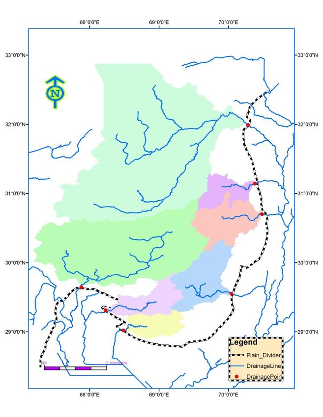
Research Journal of Recent Sciences ______________________________________________________________ ISSN 2277-2502
Vol. 3(1), 14-22, January (2014) Res. J. Recent Sci.
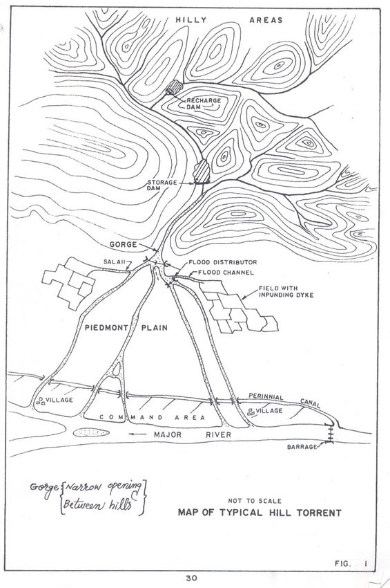
Spate mechanism: The typical spate mechanism is depicted in Quality and authenticity of datasets: As the main operation is
(figure 4)16, floodwater rush towards low height grounds. This done on SRTM based Digital Elevation Model (DEM),
water is normally causes flash floods but it fully depends upon therefore data authenticity description would lead to ensure the
the localized terrain. Before it enters to agricultural fields, it is quality of output results. SRTM was a joint project between the
divided and diverted. This study assumes that if terrain of hill National Imagery and Mapping Agency (NIMA) and the
torrents is digitally analyzed then more preferred solutions National Aeronautics and Space Administration (NASA),
would be available. The (figure 4) clearly convey its idea if we United States of America. The SRTM obtains elevation data on
have full information of the elevations then different kind of a near-global scale to generate the most complete high-
flood control structures sites would easily be define. It means resolution digital topographic database of earth19,20. Under this
more information, more sustainable irrigation system. mission, digital topographic data for 80% of the earth’s land
surface, with data points located at every 30 x 30 meters (1-arc-
second) on a latitude / longitude grid to 3-arc-second. The 3-arc-
second SRTM data has been used for this study to development
DEM.
The base map of the D.G khan and mountainous region of local
level study area provides the information to identify the target
areas of interest. The map is of large scale i.e. 1: 25,000
however additional features identification was done using SPOT
2.5 m resolution image of Vehowa, D.G. Khan. The satellite
image of Landsat TM (30 m resolution) was used for land use
classification acquired by the secondary source (Water
Resources Research Institute). The land cover data was also
used at regional level study area in the format of shape file. The
hydrological map and soil map were used to digitize the ground
water potential and to define land productivity classes
respectively at local level study area.
Research guide indicators: The research guide indicators
which were proved to be helpful during the development of
methodology and to define the scope of research work are
presented in (table 2). It was important to mention that these
research guide indicators are extracted points from literature
review.
Table-2
Research guide indicators with references
Figure-4
Research guide Indicator Research
General concept of hill torrents and spate mechanism
Spate irrigation is a floodwater harvesting
21
Datasets and specifications: The specifications of datasets and management
used in the research work are provided in (table 1). The Water sharing in spate irrigation system is its
procedural details of operations and purpose of use are 22
salient feature.
discussed under stepwise methodology. There would be wrong application of
traditional water right due to the changing 23
Table-1 cropping pattern.
Datasets specifications and sources Construction of check dams to slow down
Data type Specification the flood velocity and to trap the 24
Base map Scale (1: 250,000) sedimentation.
GPS data Point data through ground survey To find reservoir location, its feasibility
SPOT imagery 2.5 m resolution analysis and design parameters calculation 9
Landsat TM imagery 30 m resolution using GIS is sophisticated technique.
Topography sheet 1:250,000 Soil and water conservation practices are
Shuttle Radar Topography 25
3 arc resolution widely applied on highlands
Mission (SRTM) Investigating the potential for different water
Soil map 1:500,000 management techniques in spate irrigation
Hydrological map 1:500,000 26
system using the spate management model
Land cover data Shapefile and its use for decision making
International Science Congress Association 17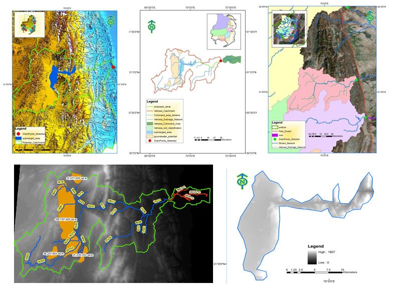
Research Journal of Recent Sciences ______________________________________________________________ ISSN 2277-2502
Vol. 3(1), 14-22, January (2014)                                                                  Res. J. Recent Sci.

Mapping: For the integration of information (satellite images,      groundwater availability. Similarly (figure 6b, c) demonstrates
maps digitization) geo-referencing and clipping were performed      the elevation model in 3D and color ramped theme respectively.
to prepare and integrated base information (figure 5).              Figure 6 (d) shows drainage network in the catchment area.
                                                                    Data layers shown in (figure 6a, d) were prepared using Arc GIS
Geo-database layers preparation: In GIS based analysis geo-         application while (figure 6b, c) with global mapper application
database is very important therefore it is very important to have   software. These layers were analyzed to identify the reservoir
a well-developed geo-database structure to exploit allof the GIS    location where floodwater would be store and to minimize the
analysis functionality27. Figure 6 (a) describes the catchment      threats of flood damages.
and command area overlaid by two layers of satellite image and

                                                       Figure-5
                Geo-referenced images overlay and demarcating prominent feature at agricultural field level

                                                        Figure-6
  a. Dam and groundwater potential, b. observing DEM flatness in command area, c. color ramped DEM and d. drainage
                                               pattern in catchment area

International Science Congress Association                                                                                    18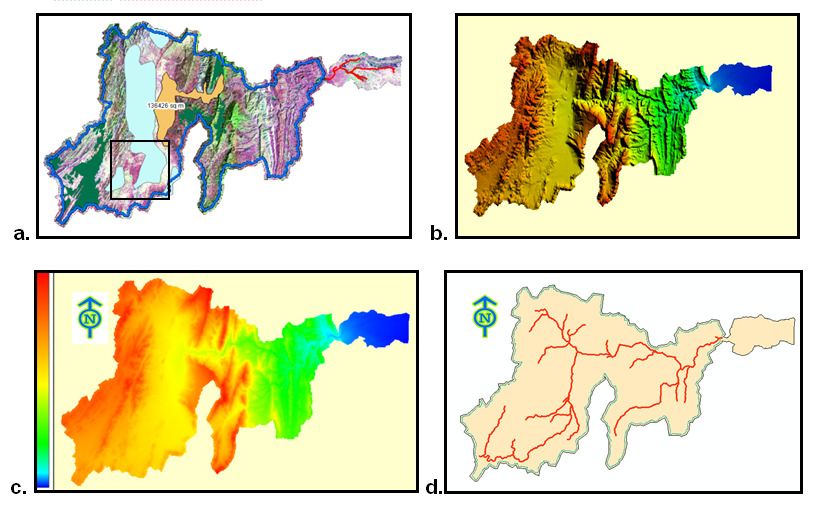
Research Journal of Recent Sciences ______________________________________________________________ ISSN 2277-2502
Vol. 3(1), 14-22, January (2014)                                                                  Res. J. Recent Sci.

Ground based survey with GPS was conducted and important          different options of reservoir height relevant dynamic scenarios
ground points were arranged and an elevation profile was          were generated. Each scenario came up with its submerged area
generated (figure 7). This profile would help to determine        under water (figure 8). The submerged area at 1270 m height
floodwater depths at different locations.                         from the datum line was captured as an image in 3D module.
                                                                  Then this image was geo-referenced with the Vehowa DEM
Reservoir siting and capacity analysis: All layers of geo-        (figure 8a). The submerged area was digitized and the Vehowa
database were merged with elevation model in 3D module of         command area DEM was clipped using this geo-referenced
global mapper and location of reservoir was identified. At        digitized submerged area boundary (figure 8b, c).

                                                            Figure-7
                                   Profile generation along agricultural structures with GPS

                a.

           b.                                                   c.
                                                            Figure-8
                     Reservoir capacity calculation and selection of site location using geo-informatics tools

International Science Congress Association                                                                                   19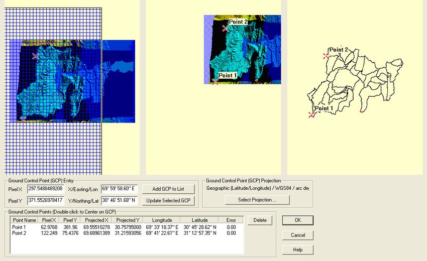
Research Journal of Recent Sciences ______________________________________________________________ ISSN 2277-2502
Vol. 3(1), 14-22, January (2014)                                                                  Res. J. Recent Sci.

Using Arc GIS, the DEM terrain was used to calculate gross        flood flows of D.G. khan hill torrents”30. In this study JICA
storage capacity of the dam. For proposed reservoir height of     improved the base line data and updated the study of NESPAK.
1270 meters from datum line, calculated water holding capacity    In this paper, further fine tuning is attempted for management
of reservoir was 1.73 Million m3. To prepare full inventory of    practices of floodwater to make agriculture more sustainable.
the reservoir, gross storage capacity change under different      (figure 10) describes the major results of this paper. A reservoir
water level below 1270 meters were calculated and graphically     with an elevation of 1270 m with gross capacity of 1.73 Million
presented in (figure 9).                                          m3 is proposed and it is assumed that after development of this
                                                                  reservoir it will be able to combat the drought and flood threats
Results and Discussion                                            for spate irrigation system. However, increased population is a
                                                                  limiting factor for the development of agriculture based
Sustainable irrigation system: During past decade, several        economy. Large tracts of land in the hill torrent areas are lying
study reports on spate irrigation by local and foreign experts    unproductive due to lack of irrigation facilities. The patchy and
have been prepared13,28,29. These reports addressed various       erratic pattern of rainfall does not support the agriculture sector.
aspects of hill torrent flood management. In 1984 National        Only a limited part of hill torrent areas is commanded by flood
Engineering Services Pakistan (Pvt) Ltd. (NESPAK) prepared a      irrigation and is dependent upon occasional runoff generated by
study entitled “Flood Management of D.G. Khan Hill Torrents”.     natural precipitation. Under this scenario, current study would
In 1992 Japan International Cooperation Agency (JICA)             contribute for the benefit of agriculture sector.
completed another study “development of irrigation based upon

                                                          Figure-9
                          Reservoir storage capacity calculations (BCM) per unit change in height

                                                          Figure-10
                                      Integration of layers for potential site possibilities

International Science Congress Association                                                                                      20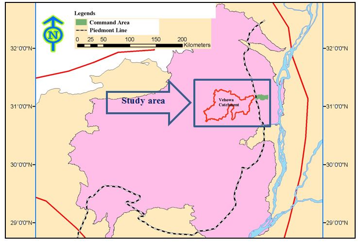
Research Journal of Recent Sciences ______________________________________________________________ ISSN 2277-2502
Vol. 3(1), 14-22, January (2014)                                                                  Res. J. Recent Sci.

Precise demarcation of catchments: A precise demarcation of             Conclusion
potential catchments (figure 11) of spate irrigation system was
completed at GIS platform. This digital information would be a          The main purpose of this study was to harness floodwater for
source for future developments and research activities and this         improved agricultural productivity and development of the
data will be used for master planning for spate irrigation system       study area through better water management practices under
which is second phase of this research work.                            economical ways. The results of this study depict that
                                                                        agricultural water management would be carried out using geo-
                                                                        informatics tools and developed methodology is a new
                                                                        contribution for the estimation of storage capacity with
                                                                        integrated tools of Arc GIS and global mapper software
                                                                        applications.

                                                                        In any kind of research study, the main discussion focuses on
                                                                        reliability of the results and it is directly linked with the
                                                                        accuracy and authenticity of the input datasets and applied
                                                                        procedure. However the reliability of proposed reservoir is
                                                                        higher due to the use of high resolution image (2.5 m spatial
                                                                        resolution) and use of more refined methods of data operations
                                                                        like careful and precise geo-referencing, GPS data integration
                                                                        under consultation of the field experienced experts of Water
                                                                        Resources Research Institute (WRRI) of National Agriculture
                                                                        Research Center.

                                                                        Acknowledgments
                                                                        Contribution of Water Resources Research Institute (WRRI) for
                                                                        providing data and is highly appreciated, where Dr. Rakhshan
                                                                        Roohi, Dr. Bashir Ahmad, Dr. Arshad Ashraf and Engr.
                                                                        Muhammad Zahir UlIkram, Program Director (Spate Irrigation)
                        Figure-11                                       supported this research. This study funded by University
   Precise demarcation of potential catchments for spate                Malaysia Pahang under research grant GRS 110334.
                        irrigation
                                                                        References
Impacts of dam on agriculture: The management of flood
flows for agricultural development essentially requires a               1.   Triana E. and Labadie J.W., GIS-Based Decision Support
comparative study of pre and post project level of production.               System for Improved Operations and Efficiency
The historical cropping pattern based on revenue record of D. G.             Conservation in Large-Scale Irrigation Systems, Journal of
Khan would be used to estimate the after effects due to                      Irrigation and Drainage Engineering, 1(1), 857–867
development of proposed floodwater storage reservoir. The                    (2012)
runoff Vehowa catchment if trapped with the proposed reservoir
                                                                        2.   Komakech H.C., Mul M.L., van der Zaag P., and
then existing cropped area would be increased moreover it can
                                                                             Rwehumbiza F.B.R., Water allocation and management in
also assume that yield per acre will also increase. It is a fact that
                                                                             an emerging spate irrigation system in Makanya
man needs to conserve the water resources and to manage water
                                                                             catchment, Tanzania, Agricultural Water Management,
system for efficient use. This need is growing more due to
                                                                             98(11), 1719–1726 (2011)
population increase. Resultantly, a sustainable and manageable
spate agricultural system would be a solution to minimize the           3.   Belaqziz S., Khabba S., Er-Raki S., Jarlan L., Le Page M.,
gaps between demand and supply of agricultural products.                     Kharrou M.H., M. El Adnani and a. Chehbouni, A new
                                                                             irrigation priority index based on remote sensing data for
This study outlines a procedural approach using GIS and remote               assessing the networks irrigation scheduling, Agricultural
sensing techniques to identify potential site for harnessing                 Water Management, 119, 1–9 (2013)
floodwater for command area. The used datasets includes                 4.   Lawrence P. and Van Steenbergen F., Improving
satellite imagery, topographic sheets, ground survey and                     Community Spate Irrigation, Report OD 154, (2005)
developed geo-database. The digitized irrigation network would
be suitable to locate potential sites for field structures as an        5.   Verheijen O. and Van Aarst S., Spate Irrigation,
improved strategy for development and up gradation of                        Livelihood Improvement and Adaptation to Climate
irrigation water network.                                                    Variability and Change, International Fund for
                                                                             Agricultural Development, 1–48 (2008)

International Science Congress Association                                                                                        21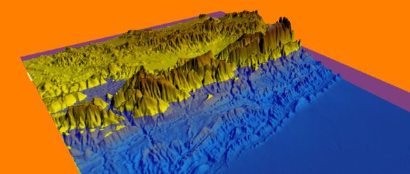
Research Journal of Recent Sciences ______________________________________________________________ ISSN 2277-2502
Vol. 3(1), 14-22, January (2014)                                                                  Res. J. Recent Sci.

6.   Ahmad S., Indigenous Water Harvesting Systems In             19. Reuter H.I., Nelson A. and Jarvis A., An evaluation of
     Pakistan, Islamabad, Water Resources Research Institute          void‐filling interpolation methods for SRTM data,
     National Agricultural Research Centre, (2000)                    International Journal of Geographical Information
7.   Ahmad S., Rod-Kohi System Development and                        Science, 21(9), 983–1008 (2007)
     Management In Pakistan – A National Project, Water           20. Rabus B., Eineder M., Roth A., and Bamler R., The shuttle
     Resources Research Institute National Agricultural               radar topography mission - a new class of digital elevation
     ResearchCentre, Islamabad, (2001)                                models acquired by spaceborne radar, ISPRS Journal of
8.   Tesfai M., A land suitability system for spate irrigation        Photogrammetry and Remote Sensing, 57(4), 241–262
     schemes in Eritrea, Soil Use and Management, 18, 77–78           (2003)
     (2002)                                                       21. van Steenbergen F., Understanding the sociology of spate
9.   Saher F.N. and Mehdi M.R., Selection of Hydraulic                irrigation: cases from Baluchistan, Journal of Arid
     Structures for Spate Irrigation, in International Congress       Environments, 35(2), 349–365 (1997)
     on Irrigation and Drainage Workshop on Capacity              22. Jamali H. and Hufty M., Transformation or degradation :
     Building and Training in the Water Sector, 69–77 (2008)          transition from karez to tubewell irrigation and its
10. van Steenbergen F., Lawrence P., Haile A.M., Salman M.            implications for power relations and social structure in
    and Faurès J.M., Economics of spate irrigation, in                Baluchistan, Pakistan, in 13th IASC Biennial International
    Guidelines on spate irrigation, Rome: Food and                    Conference, 1–18 (2011)
    Agriculture Organization of the United Nations (2010)         23. Bahamish A.A., Final Report On Legal Survey of Existing
11. Ahmad M.D., Turral H. and Nazeer A., Diagnosing                   Traditional Water Rights in the Spate Irrigation Systems in
    irrigation performance and water productivity through             WadiZabid and WadiTuban, (2004)
    satellite remote sensing and secondary data in a large        24. Christine P., Jerzy S., Hanna W. and Krzysztof R.,
    irrigation system of Pakistan, Agricultural Water                 Dynamic slowdown: A flood mitigation strategy
    Management, 96(4), 551–564 (2009)                                 complying with the integrated management concept –
12. Ahmad H., Bokhari J.I., Tallat Q. and Siddiqui M.,                implementation in a small mountainous catchment,
    Flashflood risk assessment in Pakistan, in Pakistan               International Journal of River Basin Management, 3(2),
    Engineering Congress, 71st Annual Session Proceedings,            75–85 (2005)
    707, 696–708 (2011)                                           25. Bekele W. and Drake L., Soil and water conservation
13. Javed M.Y., Nadeem M. and Javed F., Technical                     decision behaviour of subsistence farmers in the Eastern
    Assistance Consultant’s Report on Pakistan : Additional           Highlands of Ethiopia: a case study of the Hunde-Lafto
    Works for the Preparation of Hill Torrent Management              area, Ecological Economics, 46(3), 437–451 (2003)
    Plan (2007)                                                   26. K. El-Askari, Investigating the potential for efficient water
14. Yoshikawa N., Nagao N. and Misawa S., Evaluation of the           management in spate irrigation schemes using the Spate
    flood mitigation effect of a Paddy Field Dam project,             Management Model, Journal of Applied Irrigation
    Agricultural Water Management, 97(2), 259–270 (2010)              Science, 40(2), 177–192 (2005)

15. Wagner I. and Zalewski M., Effect of hydrological patterns    27. Minár J., Mentlík P., Jedlička K. and Barka I.,
    of tributaries on biotic processes in a lowland reservoir —       Geomorphological Information System: Idea and Options
    consequences for restoration, Ecological Engineering,             For Practical Implementation, Eomorphologic Informatics
    16(1), 79–90 (2000)                                               System–prototype, 247–266 (2005)

16. NESPAK, Master Feasibility Studies for Flood                  28. Water Resources Research Institute (WRRI), National
    Management of Hill Torrents of Pakistan, Supporting               Agriculture Research Council (NARC), Islamabad Issues /
    Volume-III, Punjab Province, National Engineering                 Problems, (1991)
    Services Pakistan (1998)                                      29. Rehabilitation L. and Oosterbaan R., Spate Irrigation :
17. NESPAK, National Flood Commission Plan, Lahore,                   Water Harvesting and Agricultural Land Development
    (1978)                                                            Options in the NWFR of Pakistan Water Harvesting and
                                                                      Agricultural Land Development Options in the NWFR of
18. Nawaz Khan A. and Ali Z., Evaluation of the Chashma               Pakistan Cover image, 1–27 (2010)
    Right Bank Irrigation Project and Strategy Formulation
    Using the Swot Approach, Irrigation and Drainage, 61(4),      30. FFC, Pakistan Water Sector Strategy, Medium Term
    464–476 (2012)                                                    Investment Plan, Volume 3, Islamabad, Pakistan, (2002)

International Science Congress Association                                                                                    22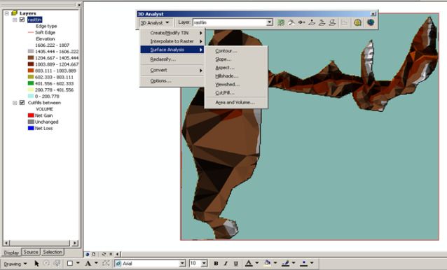
You can also read