WATER QUALITY SAMPLING FROM AN UNMANNED AERIAL VEHICLE
←
→
Page content transcription
If your browser does not render page correctly, please read the page content below
WATER QUALITY SAMPLING FROM AN
UNMANNED AERIAL VEHICLE
T. Porter (Auckland Council), T. Gower and E. Clayton (Pattle Delamore Partners
Ltd)

ABSTRACT
Water quality sampling can be a hazardous activity. Field staff contend with weather,
exposure to contaminants, use of various sampling platforms, and access that can be
restrictive due to bank vegetation and heights.        While Professional Scientific and
Technical Services is not recognized as a high-risk industry by New Zealand legislation,
Worksafe notified injuries occurred at a rate of twenty-five incidents per thousand
employees in 2017. In the last ten years there has been one registered fatality. Finding
sampling solutions that keep hazards to a minimum and reduce staff risk can mean
eliminating sampling points that are deemed too hazardous to access.

This presentation will detail a new process for the collection of marine water samples.
Samples were required for enterococci analysis from four popular swimming beaches
along Auckland’s east coast: Takapuna, Narrow Neck, Kohimarama and Mission Bay.
These beaches are popular not only for casual swimming and access by members of the
public, but also support organized summer swimming events (Summer Swim Series), and
tourist operations (kayaking and stand-up paddle boarding) where the ‘contact zone’ of
human interaction with water extends much further off shore. Typical water quality
sampling that consists of a grab sample at knee depth may not be accurately measuring
enterococci counts at representative locations for such activities.

In order to measure enterococci at these locations (and provide validation of the current
Safeswim model), surface water samples are required to be collected in varying depths
along transects that extend from the beach out to deep water. Across each transect
samples need to be collected from just below the surface at six locations where the depth
of water is as follows: at knee, waist, 1.5 , 2 , 4 and 6 metres. In the past, this would
have required the use of a powered vessel with a Maritime New Zealand certificate of
survey, qualified crew, and the added expense that is associated with such a sampling
platform. Alternatively, a non-powered vessel (such as a kayak) can be used, thereby
increasing the risk of staff being exposed to water related health and safety hazards.

In this project example, a waterproof drone was fitted with a tether to fly to waypoints
and dip a sampling vessel. The drone can lift up to a one kilogram weight, allowing for
adequate sampling volume for a range of tests if required. For each sampling transect, a
one kilometre profile was surveyed using an Acoustic Doppler Profiler (ADP), allowing for
the measurement of depth at a known tide datum. As each sampling run is conducted at
different tide levels, reference to this surveyed transect can be made when calculating
sample depth locations and the required sampling locations can be pulled from the
surveyed profile. The drone’s autopilot is then used to fly to these sampling locations and
collect the required water samples.

This methodology eliminated two major Health and Safety hazards that were identified at
the beginning of the project: Working around deep water and working from a mobile
sampling platform.

KEYWORDS
Water quality, drone, Health and Safety, communities, field sampling.
1     INTRODUCTION
1.1    IMPORTANCE OF A HEALTHY MARINE ENVIRONMENT
The health of the marine environment is a major concern for many Aucklanders. In 2018,
94 per cent of beach users rated the quality of the water at Auckland’s beaches and
lagoons as important (Allpress et al., 2018).

Many waterways and beaches in Auckland are unsafe for swimming after rainfall events,
and as of February 2019, 12 beaches have long-term warnings advising against
swimming due to the long-term water quality. Contamination of these swimming sites
can come from a variety of sources including birds, dogs, livestock, onsite wastewater
systems, wastewater overflows and wastewater contamination of stormwater.

Auckland Council and Watercare are working to investigate and fix these water quality
issues. In 2018 a water quality targeted rate worth approx. $400 million over 10 years
was passed, with 61% of respondents to the public consultation in favour of an
accelerated water quality improvement programme. One of the main reasons
respondents stated for supporting the targeted rate is the value of recreational use of
water, especially swimming at beaches (Auckland Council, 2018).

1.2   SAFESWIM

Auckland Council has enabled the public to make an informed decision on the potential
health risks of swimming by providing information through Safeswim.

Safeswim is a partnership between Auckland Council, Watercare, Surf Life Saving
Northern Region and the Auckland Regional Public Health Service. Safeswim uses
predictive models, meteorological data and information on pollution events to provide
real-time forecasts on water quality at 115 swimming sites (both marine and freshwater)
across Auckland (as of February 2019).

In late 2018 a swim event pin was added onto the Safeswim website. This allows specific
advice for some offshore swimming events to be provided, rather than risk being based
on the nearest Safeswim site. The Safeswim homepage showing real-time forecast of
water quality, and the swim event pin, are shown in Figure 1.

      A                                              B

Figure 1. Screenshot of Safeswim website (A) showing real-time forecast of water quality, and
swim event pin (B) on Safeswim website.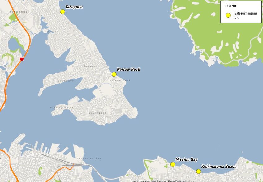
1.3 PROJECT BRIEF
In keeping with New Zealand guidelines, Safeswim usually monitors and reports water
quality in up to 0.5 metres water depth.
However previous investigations at Takapuna identified that, while the risk of poor water
quality following rainfall generally persists near to the shore, the water quality at the
surface further away from the shore beyond this point (approximately 1.5 m water
depth) generally remained good and did not exceed public health guidelines.
This is particularly relevant to ocean swimming events and other watersports (such as
stand-up paddle boarding) which are often take place in deeper water. In 2018 a series
of swim events in Auckland were cancelled or moved due to Safeswim indicating a high
risk at the nearest beach at the time of the events.
The enterococci sampling detailed in this paper will enable an increased understanding of
the varying nature of contamination at those beaches where swimming events are
routinely held. The samples will also be used as part of the continuing review and
refinement of the Safeswim models.
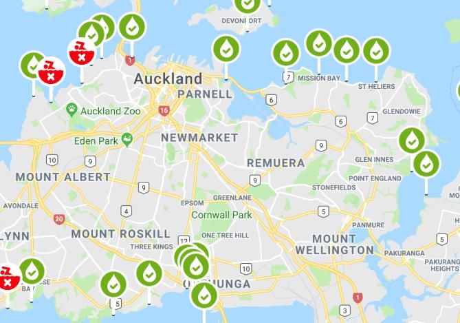
Four beaches were chosen for sampling due to their popularity for offshore swimming
events. These are Takapuna, Narrow Neck, Kohimarama and Mission Bay (Fig. 2). Each
beach was to have three transects sampled (Fig. 3), with six samples collected for
analysis from each transect. Samples were to be collected from just below the surface at
knee, waist, 1.5 m, 2 m, 4 m and 6 m depths, up to a maximum of 1 kilometre from
shore.
Figure 2. Location of four Safeswim beaches to be sampled.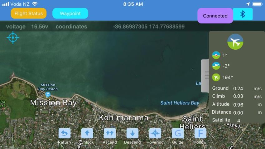
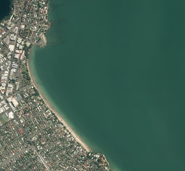
Figure 3. Maps of the sampling transects for each beach: Mission Bay and Kohimarama (A),
Takapuna (B), and Narrow Neck (C). All coordinates in NZTM2000.
2    CHALLENGES OF TRADITIONAL MARINE SAMPLING
In shallow nearshore waters, water quality sampling typically involves hand-collecting
samples at a given depth, for example, knee and waist. For deeper offshore waters, a
vessel of some sort is required, and this is how such sampling programmes have been
conducted in the past. In addition to the Health and Safety at Work Act 2015, the
Maritime Transport Act 1994 applies to commercial maritime operators of powered
vessels. In order to use a powered vessel for a sampling operation, the vessel is required
to hold survey certificate from Maritime New Zealand, and employ a correctly licensed
captain and crew (Maritime New Zealand, n.d.). If a certified crew or vessel are not
available, only a non-powered vessel (such as a kayak) is permitted. For sampling
regimes involving large distances offshore, such as described in the project brief, a kayak
is unlikely to be a safe or practical option. Whether using a powered or non-powered
vessel, there will always be inherent health and safety issues associated with working
over deep water, on an unstable sampling platform, and in potentially poor weather.
Staff would be exposed to a range of hazards, including drowning, exposure to
pathogens, and hypothermia that can only partly be controlled when sampling in such
conditions.

The cost of either chartering or purchasing such a vessel, and maintaining the required
crew and certifications is not insignificant (can be upwards of $3000 per day for a
certified survey vessel and captain). Personnel requirements may also be higher than
other sampling projects, as the vessel crew would be in addition to the normal staff
required to conduct the sampling. This is especially so if both deep and shallow water
sampling are required, as separate teams would be needed to collect offshore and
nearshore samples. In addition to the health and safety issues and costs, there are also
logistical difficulties that come with boat-based sampling. For example, arranging a vessel
and crew, and launching can take time that may not be available for some sampling
programmes, such as examining wastewater overflows immediately after heavy rain
events. Therefore, a novel method of water quality sampling that utilises the emerging
technology of unmanned aerial vehicles (UAVs), or drones, was developed that addressed
the logistical, financial, and health and safety issues of traditional sampling approaches.

3    A NOVEL APPROACH: WATER QUALITY SAMPLING WITH A DRONE
Over the last five years, the increasing accessibility of UAVs has presented exciting
opportunities for a variety of commercial and scientific applications in environmental
monitoring (Manfreda et al., 2018). Drones are now commonly used for aerial
reconnaissance of study/work sites, multispectral imaging for agriculture, and
topographic surveying of landslides. The technology presents the most benefit in
situations/locations that are difficult or unsafe to access via normal means. In recent
years there have been attempts to develop drones as water sampling platforms (Koparan
et al. 2018; Ore et al. 2015). However, such work has often involved high-end UAVs, or
custom-built sampling equipment, such as remote-controlled on-board pumps, and have
not been weatherproof. Despite the accessibility and flexibility of UAV technology, it has
not been widely adopted for water quality sampling, and we are aware of no examples of
drones being operationalised for such programmes in New Zealand. We therefore present
a novel technique that utilises an off-the-shelf, waterproof UAV and standard sampling
equipment that could be applied to a wide variety of water quality projects. The sub-
sections which follow detail the equipment and method that has been developed.
3.1        EQUIPMENT AND PERSONNEL
There are many makes and models of UAV available for purchase, however, most are not
water resistant, making them unsuitable for operations in poor weather. Therefore, in this
project a fully waterproof drone, designed ostensibly for fishing, is utilised for sampling in
a wide range of conditions. Specific equipment that is used includes:

      •   SwellPro Splash Drone 3 Auto IP67 rated waterproof, floating UAV (Fig. 4)

      •   High-gain 5.8GHz antenna to maximise range of video transmission from on-board
          camera

      •   HydraSleeve spill-proof groundwater sampler for sample collection

      •   Lead weight and 2 meter tether to suspend Hydrasleeve below UAV

      •   Fishing float for controlling the depth of the sample

               Figure 4. The SwellPro Splash Drone 3 Auto. Source: www.swellpro.com.
A team of three people are employed to undertake the sampling method described below.
This includes a dedicated UAV pilot responsible for safely operating the aircraft and
navigating to the correct sample locations. The second team member is responsible for
handling water samples, including collecting the nearshore samples (knee and waist
depth only), and exchanging Hydrasleeves from the UAV between flights. The third
person on site is primarily for safety, ensuring members of the public remain clear of the
drone take-off and landing area, and watching for other aircraft. The third person can
also engage with any beachgoers interested in the sampling.

3.2        DETERMINING SAMPLE LOCATIONS
The project brief requires samples to be collected along three shore-normal transects at
each beach. These samples need to be from just below the surface at six different
depths: knee, waist, 1.5 m, 2 m, 4 m and 6 m. To determine the correct locations for
sampling, calm weather bathymetric surveys of each transect were conducted using a
SonTek M9 Acoustic Doppler Profiler (ADP), out to a distance of 1000 m. A SonTek
Castaway CTD was used to provide salinity corrections to the acoustic data. The resultant
high-resolution bathymetric profiles are combined with tidal information to determine the
offshore distance (from a predetermined take-off coordinate, usually just seaward of the
treeline or seawall) at which each sample must be taken. The water level offset between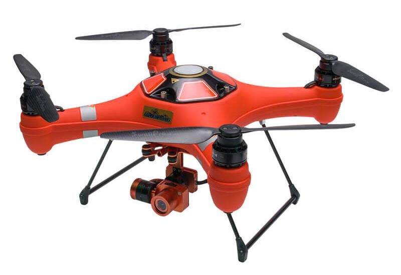
the date and time of surveying and the sampling run is calculated using a tidal forecast
model supplied by Land Information New Zealand (10 minute resolution, Auckland port
tide gauge). Flying distances are calculated and plotted automatically for a given
sampling time (Fig. 5). In cases when lower tides mean the water remains shallow for
several kilometres offshore a maximum sampling distance of 1000 m is adopted. With the
sampling location calculator installed on a portable tablet, the required flying distances
are easily updated on site at the time of each flight, thereby maximising the accuracy of
tidal offsets and depth estimations (Fig. 6).
3
1
Profile
-1 1.5m 2m 4m 6m
Depth (m)
-3 Survey Water Level
-5 Sampling Water Level
-7 Sampling Location
-9
-11
0 100 200 300 400 500 600 700 800 900 1000 1100
Distance from shore (m)
Figure 5. Bathymetric profile of Takapuna Beach (northern transect) showing tidal offset and
sampling locations for the 1.5, 2, 4, and 6 meter samples for a run at 11/01/2019 11:00. Vertical
axis displays depth relative to the water surface at the time the bathymetric survey was
conducted.
Sample Distances (m from high tide
beach) for each of the below depths
Sample Distance Calculator Enter data only for cells in white adjusted for tide. If depth is beyond
drone range, distance set to 1000m.
Date/time of intended
Date/Time of M9 survey Tide height (m) at time of sampling run - nearest Tide height at time of Tidal differnce between
Transect (NZST) survey 10min (NZST) sampling (m) survey and sampling (m) -1.5 -2 -4 -6
MissionNorth 11/01/2019 6:50 1.457 25/01/2019 12:30 2.85 1.393 55 69 229 354
MissionMid 11/01/2019 7:10 1.62 25/01/2019 15:00 0.942 -0.678 233 261 410 1000
MissionSouth 11/01/2019 7:50 1.968 25/01/2019 13:30 2.194 0.226 69 134 342 1000
KohiNorth 11/01/2019 8:20 2.235 25/01/2019 14:00 1.79 -0.445 111 213 342 1000
KohiMid 11/01/2019 8:50 2.49 25/01/2019 14:30 1.404 -1.086 208 254 472 1000
KohiSouth 11/01/2019 9:20 2.714 25/01/2019 15:00 1.05 -1.664 335 358 629 1000
TakaNorth 11/01/2019 11:00 3.074 25/01/2019 15:30 0.746 -2.328 270 312 475 731
TakaMid 11/01/2019 11:30 3.032 25/01/2019 16:00 0.516 -2.516 173 210 346 565
TakaSouth 11/01/2019 12:10 2.859 25/01/2019 16:30 0.379 -2.48 204 230 356 487
NarrowNorth 11/01/2019 13:40 2.1 25/01/2019 20:00 1.916 -0.184 97 127 237 410
NarrowMid 11/01/2019 14:10 1.808 26/01/2019 20:00 1.321 -0.487 122 138 199 419
NarrowSouth 11/01/2019 14:30 1.621 27/01/2019 20:00 0.892 -0.729 97 112 180 440
Figure 6. Example output of the sample distance calculator used in the field to determine flying
distances from shore.
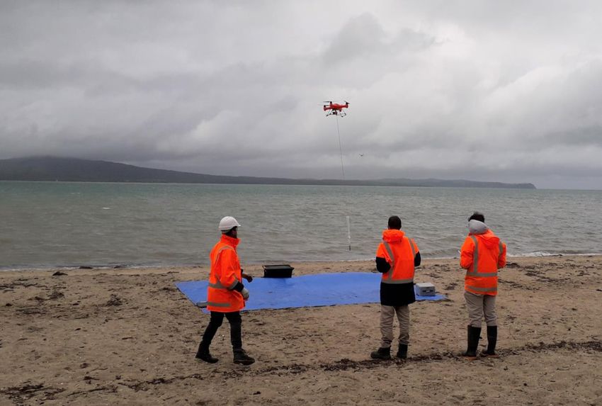
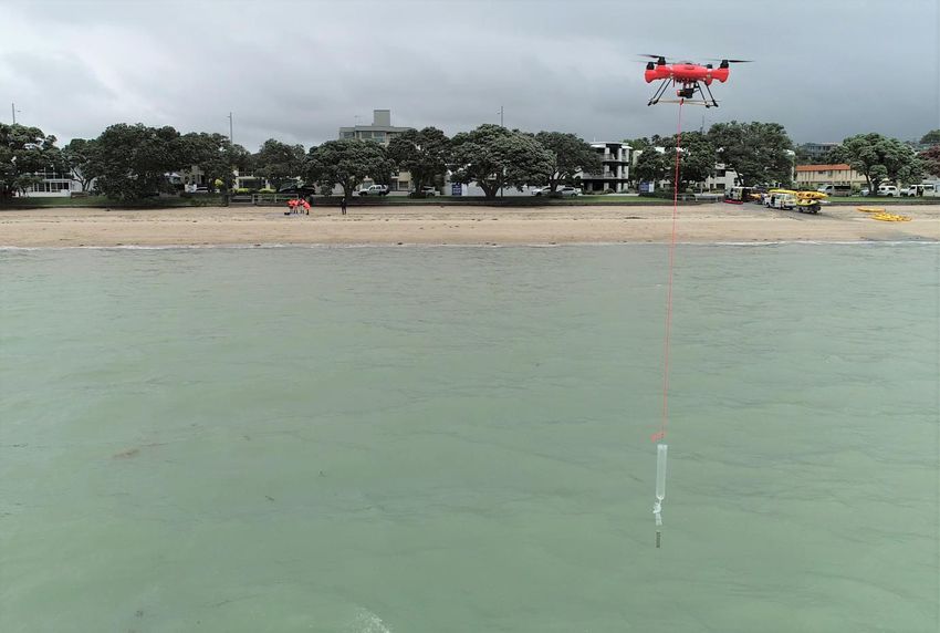
3.3 COLLECTING SAMPLES
The UAV is navigated to the specified sample location using the SwellPro Fly app (Fig. 7)
and autopilot function. Waypoints are used to fly the drone along the sample transect line
at a pre-set altitude. When the pre-determined distance is reached, the drone descends,
submerging the HydraSleeve and collecting the water sample, before ascending and
returning to its take-off position. A float is fixed to the tether to ensure the sample is
taken from near the surface (Fig. 8). To retrieve the sample, the drone hovers above the
beach while one staff member disconnects the HydraSleeve, replaces it with a sterile
empty unit, and then decants the sample into a pre-labelled 150 ml container. The drone
then departs to collect the next sample, with the process repeating several times per
flight (Fig. 9). The number of samples that can be collected in one flight depends on the
distance covered and battery capacity (this project uses 5200mAh batteries with a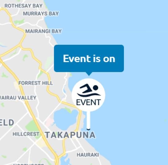
10-15 minute flying time, allowing for up to four samples per flight). Meanwhile, shallow
water samples are collected by hand from the beach. Photographs of the drone sampling
in operation at Kohimarama Beach are provided in Figures 10 and 11.

Figure 7. Screen capture of the SwellPro Fly app used for programming waypoints into the Splash
Drone’s on-board autopilot.

                                1

                                                           2

              Float

             HydraSleeve

             Weight

                                                                  Fixed sample depth

                      Figure 8. Diagram depicting the sampling procedure used.
4 3 2 1
Figure 9. Diagram displaying flight sequence in which multiple samples are collected in one flight.
Figure 10. View from shore of drone sampling operation at Kohimarama Beach.Figure 11. View from offshore of drone sampling operation at Kohimarama Beach. 4 BENEFITS OF A UAV-CENTRED APPROACH There are a range of benefits to a UAV-based sampling programme, versus using a boat, including reduced hazards to personnel, cost savings, and logistical improvements. Regarding health and safety, this method is fundamentally attractive as it avoids requiring staff to work over deep water, thereby reducing exposure to drowning and other serious hazards. Further, because all sampling is conducted from the beach (instead of on a boat and the beach simultaneously), a smaller team can be used, thereby putting less people at risk. Cost savings come primarily from the lack of need to use a certified vessel and crew, therefore less field expenses and less personnel costs are incurred. For example, the UAV described above can be purchased off-the-shelf for approximately $3,000 —similar to, or cheaper than, the cost of chartering a vessel and captain for just one day. Depending on the nature of the project, there are potential time savings also, as once onsite repeat samples can be collected rapidly. Collecting samples to meet a weather window (for example post-wet weather) can require sampling at short notice. The flexibility of drone sampling can thereby be a advantage over having to arrange the launch of a vessel. Sampling from a drone can also be more practical during high wave conditions, where sampling from a vessel may be problematic, providing a sufficiently long tether and high enough altitude are employed to keep clear of swell.
A supplementary benefit of UAV monitoring is that it is visible to beachgoers and
therefore the sampling may generate interest from the public. The third member of the
sampling team will be in place to engage with the public about the sampling programme
and Safeswim.

5    RISKS AND LIMITATIONS
Despite the various health and safety, financial, and logistical advantages of drone-based
sampling, as with any method there are still risks and limitations. The majority of the
health and safety hazards are related to the use of the UAV, and the risk of crash or
collision with people, property, or other aircraft. However, there are controls that can
substantially reduce the likelihood of such events (in addition to complying with all Civil
Aviation Authority (CAA) rules, in particular Part 101). First, check that it is safe and legal
to fly in the airspace where sampling is to be conducted and log a flight plan
(www.airshare.co.nz). Other important safety measures include maintaining a take-off
and landing area that is clear of people (aside from necessary personnel), not flying
directly over people, maintaining a low altitude, and having a dedicated safety observer
(in addition to the pilot) to watch for other airspace users. If such controls are put in
place, the greatest risk likely applies to staff working under the drone, for example, when
exchanging samples. Therefore a hard hat, eye protection, and cut resistant gloves are a
necessity, in addition high-visibility attire and steel-toed boots.

There is also a financial risk of loss of the UAV. Using a waterproof and buoyant model
(that can land on and take off from water) is useful, nevertheless, if a malfunction occurs
while flying offshore, immediate retrieval may not be possible. Ensuring equipment is well
maintained, that there is always more than sufficient battery capacity for the return run,
and never flying out of sight can make a loss far less likely. The risk of loss can be further
mitigated by purchasing a UAV that includes a locator beacon.

There are several other technical and logistical limitations that should be considered when
deciding on whether method described is appropriate for a given task. Firstly, the method
does not include the ability to directly measure water depth at the time of sampling.
While the ADP technology used for bathymetric surveys is sufficiently accurate for
sampling purposes, the method used for determining water level at the time of sampling
includes inherent uncertainty. In particular, it relies on a tidal model for a single location
and does not consider factors such as storm surge. Discrepancies between the predicted
and actual tidal level at the sampling location mean that the depths used to determine
sampling locations must be considered approximate only.

Other limitations relate to the particular choice of UAV, and drone technology in general.
There are few waterproof drones on the market, and the Splash Drone contains a
somewhat rudimentary autopilot system compared to other non-waterproof models,
limiting its capacity for more complicated, pre-programmed flight plans. Additionally there
will always be a limit to the distance that can be covered that will be less than what is
possible with a boat, both due to the transmission range of the on-board antenna, and
the battery capacity (the model used here has a maximum transmission range of just
over 1 km). Weather conditions can also hamper sampling efforts, as most commercially
available UAVs are rated for wind speeds up to 30 or 40 km/hr. Visibility can also be an
issue, especially in bad weather, as CAA rules require visual contact to be maintained by
the ground crew.
6    SUMMARY:
This project has shown the benefits which UAV can bring to collecting water quality
samples, with the potential to be safer, faster and cheaper than traditional methods.

Auckland Council has utilised UAV sampling in this project to better understand the water
quality of coastal marine areas which usually would require sampling from a vessel.

This work will help feed into the Safeswim predictive models to provide better information
to Aucklanders about the risk to human health of recreational activities at any given time
or beach.

7    REFERENCES

Allpress, J., Clark, A., Rootham, E., Huang, T. (2018) Safeswim Impact Evaluation Have
     improvements to Safeswim changed Aucklanders’ awareness and behaviour? [online]
     http://www.knowledgeauckland.org.nz/assets/publications/TR2018-004-Safeswim-
     impact-evaluation.pdf

Auckland Council (2018) Water Quality Targetted Rate [online]
   https://ourauckland.aucklandcouncil.govt.nz/media/19292/attachment-b-water-
   quality-targeted-rate.pdf

Koparan, C., Koc, A. B., Privette, C. V., Sawyer, C. B., & Sharp, J. L. (2018). Evaluation
   of a UAV-assisted autonomous water sampling. Water (Switzerland), 10(5).
   https://doi.org/10.3390/w10050655

Manfreda, S., McCabe, M. F., Miller, P. E., Lucas, R., Madrigal, V. P., Mallinis, G., … Toth,
   B. (2018). On the use of unmanned aerial systems for environmental monitoring.
   Remote Sensing, 10(4). https://doi.org/10.3390/rs10040641

Maritime New Zealand. (n.d.). Health And Safety: A Guide                     For   Mariners.
    https://www.maritimenz.govt.nz/commercial/safety/health-and-
    safety/documents/HS-guide-for-mariners.pdf

Ore, J.-P., Elbaum, S., Burgin, A., & Detweiler, C. (2015). Autonomous Aerial Water
    Sampling.       Journal     of    Field      Robotics,    32(8),    1095–1113.
    https://doi.org/10.1002/rob.21591
You can also read