11.0 Flooding and geomorphology - Idemitsu Australia Resources
←
→
Page content transcription
If your browser does not render page correctly, please read the page content below
IDEMITSU AUSTRALIA RESOURCES

11.0 Flooding and geomorphology
11.1         Introduction
This chapter discusses the outcomes of the flood hydrology and geomorphology assessments completed for
the Ensham Life of Mine Extension Project (the proposed project, hereafter referred to as ‘the Project’). The
chapter includes assessment of potential geomorphic impact of the Project on the Nogoa River channel,
floodplain and tributaries, and the consequential impacts on environmental values (EVs) of the Nogoa River
system.
The flood hydrology technical report is presented in Appendix E-3 (Hydrology and flooding). The supporting
Hydrology and flooding report in Appendix E-3 (Hydrology and flooding) has been prepared based on an
earlier project definition. The project definition presented in this chapter supersedes that definition and does
not require any additional changes to the study.

 Environmental objectives and outcomes
 The Project seeks to protect environmental values in the vicinity of the Project Site relating to water. Within
 the Project Site, environmental values specifically relate to the those set out under the Environmental
 Protection (Water and Wetland Biodiversity) Policy 2019 (EPP WWB) and include aquatic ecosystems,
 irrigation, farm supply/use, stock water, aquaculture, human consumer, primary recreation, secondary
 recreation, visual recreation, drinking water, industrial use, and cultural and spiritual values.
 As the Project is an extension of the current underground mining operation at Ensham Mine, impacts to
 water are not considered to be significant. However, given the potential risks to downstream water
 resources, flooding and geomorphology has been assessed as a critical matter in the environmental impact
 statement (EIS) on a precautionary basis.
 The existing Ensham Mine currently manages impacts to water in accordance with the requirements of
 Environmental Authority (EA) EPML00732813.
 The Subsidence Report, which has been independently peer reviewed, supports that subsidence, would be
 typically less than 40 mm (noting that seasonal variation in moisture content can result in up to 50 mm
 changes in surface levels) based on a factor of safety of 1.6.
 Given the predicted level of subsidence, the Project is not expected to generate any flooding or
 geomorphological impacts on water values at the Project Site. As such, no additional mitigation measures
 have been proposed.

11.2         Legislation and policy
11.2.1       Water Act 2000
In Queensland, the Water Act 2000 (Qld) (Water Act) is the primary statutory document that establishes a
framework for the planning, allocation and use of non-tidal water. With respect to the geomorphic aspects of
the Project, the Water Act provides a framework for sustaining the health of ecosystems, water quality, water-
dependent ecological processes and biological diversity associated with watercourses, lakes, springs, aquifers
and other natural water systems, including, where practicable, reversing degradation that has occurred.

ENSHAM LIFE OF MINE EXTENSION PROJECT ENVIRONMENTAL IMPACT STATEMENT                                         11-1
IDEMITSU AUSTRALIA RESOURCES
11.2.2 Environmental Protection (Water and Wetland Biodiversity) Policy 2019
The EPP WWB is the primary instrument for surface water management under the Environmental Protection
Act 1994 (Qld). The EPP WWB governs discharge to land, surface water and groundwater, aims to protect
EVs and sets water quality guidelines and objectives.
EVs for waterways draining the Project Site are provided in the Nogoa River Sub-basin EV and water quality
objectives scheduling document, prepared pursuant to the EPP WWB. The Project is located within the Lower
Nogoa and Theresa Creek tributaries and Lower Nogoa main channel.
The EVs for waterways draining the Project Site are:
aquatic ecosystems
irrigation
farm water supply
stock watering
aquaculture (main channel only)
human consumers of aquatic foods
primary recreation
secondary recreation
visual recreation
drinking water supply
industrial use
cultural and spiritual values.
The geomorphic impacts of the Project have been assessed with consideration to the EVs.
11.2.3 Environmental authority EPML00732813 Condition G2
The EA for the existing Ensham Mine contains Condition G2 which requires a Factor of Safety (FoS) for the
bord and pillar underground structures for areas connected with flood areas and waterways. Condition G2
Bord and pillar – factors of safety states that:
“The environmental authority holder will determine relevant pillar and roadway dimensions to ensure that the
following factors of safety are achieved:
a) 2.11 for bord and pillar workings beneath the Nogoa River anabranch;
b) 2.11 for access roadways beneath the Nogoa River to connect the bord and pillar and longwall mining
areas; and
c) 1.6 for all other bord and pillar workings beneath the floodplain of the Nogoa River.”
It is noted that Ensham propose a 1.6 FoS for the Project, including below the Nogoa River and Nogoa
River anabranch as discussed in Chapter 8 (Land resource) and Appendix B-2 (Subsidence). The
Subsidence Report which includes the FoS of 1.6 was prepared by Gordon Geotechniques Pty Ltd (RPEQ)
and identifies that subsidence would typically be less than 40 mm reducing to typically less than 20 mm
above the bell out pillars. The findings of the Subsidence Report are supported by bord and pillar mining
guidance published by the IESC which states:
ENSHAM LIFE OF MINE EXTENSION PROJECT ENVIRONMENTAL IMPACT STATEMENT 11-2
IDEMITSU AUSTRALIA RESOURCES
d) “Where the pillars have been designed to be stable, the vertical subsidence is typically less than 20
mm. Natural or seasonal variations in the surface levels, due to the wetting and drying of soils, are
approximately 20 mm; hence, vertical subsidence of less than 20 mm can be considered to be no
more than the variations that occur from natural processes and should have negligible impact on
surface infrastructure.”
This is consistent with Ensham’s approach of developing stable pillars that result in negligible subsidence.
Whilst the Commonwealth guidance discusses seasonal variation of 20 mm having a negligible effect on
surface infrastructure, the guidance also states that seasonal variation can be as high as 50 mm or more due
to changes in moisture content.
The findings of the Subsidence Report have been peer reviewed by Mine Advice (Russell Frith - RPEQ) and
Byrnes Geotechnical (Ross Seedsman - RPEQ). For further information on subsidence and the FoS refer to
Appendix B-2 (Subsidence).
11.3 Methodology
11.3.1 Flooding
The hydrology and flooding assessment for the Project draws upon a number of previous studies undertaken
in the Project Site. Previous flood studies applicable to the Project include:
flood study of the Nogoa River catchment upstream and downstream of the Ensham Mine (KBR, 2013))
flood study of the rehabilitation and closure planning for Ensham Mine’s existing operations (HEC,
2019).
The initial flood study (KBR, 2013) comprised of both hydrological and hydraulic modelling to simulate rainfall
runoff (XP-RAFTS) and flow depths and velocities within the catchment (TUFLOW). Modelling was calibrated
against previous high rainfall events at Ensham Mine, including the December 2010/2011 event which is the
largest event to have been recorded in the region in recent history. The modelling was also peer reviewed
independently as part of the Ensham Coal Mine flood levee certification.
Supplementary flood modelling undertaken for the Ensham Mine rehabilitation and closure planning (HEC,
2019) built upon the previous models developed by KBR. The updated model predicted stream flow across
the Ensham Mine and the resulting peak flow rates near the Duck Ponds gauging station, located on the Nogoa
River downstream of the Project Site. Further calibration of the hydraulic model was undertaken which
confirmed the validity of the model in predicting flood events at the Duck Ponds gauging station.
Model simulations were undertaken to forecast peak flood levels, depths, afflux and velocities for the range of
annual exceedance probability (AEP) flow events at Ensham Mine. A flood frequency analysis was performed
on the peak annual flows recorded at the Duck Ponds gauging station based on 24 years of available data.
As the subsidence assessment undertaken for the Project (Appendix B-2 (Subsidence)) predicts that
subsidence in the Project Site (if it were to occur) will be less than 40 mm (noting that seasonal variation in
moisture content can result in up to 50 mm changes in surface levels), previous flood modelling results are
considered applicable to the Project and therefore remain unchanged from the approved operations at the
existing Ensham Mine.
ENSHAM LIFE OF MINE EXTENSION PROJECT ENVIRONMENTAL IMPACT STATEMENT 11-3
IDEMITSU AUSTRALIA RESOURCES
11.3.2 Geomorphology
The geomorphic properties and dominant erosion mechanisms of the Nogoa River have been characterised
to assist in the assessment of potential impacts on river and anabranch geomorphology within the Project Site.
The assessment relies upon site inspections and the results of detailed hydraulic modelling of the river and
floodplain under existing conditions and following development of the Project (HEC, 2019).
The flood modelling informs the flooding characteristics of relevance to the assessment of morphology of the
Nogoa River floodplain. For this study, the ‘regional’ model was modified by reducing the grid size from 30
metres (m) to 10 m to improve the model resolution within the channel (WRM model). The WRM model was
then re-run without altering the hydrology or other hydraulic model parameters derived in the regional model.
No other parameters in the model were reviewed or altered as part of this assessment.
The modelling has been used to define the capacity of the Nogoa River channel together with the frequency
at which the various flood channels receive Nogoa River flows. The distribution of flow in the flood channels
has also been determined. Velocity and shear stress have been used to characterise hydraulic conditions of
relevance to the floodplain morphology.
The modelling included:
An assessment of the 10 per cent AEP design flood to represent the behaviour of the river at bank full
flow conditions. The bank full flow is the maximum flow that the channel can carry before it overflows onto
the adjacent floodplain. In geomorphologic studies, the bank full flow is often considered to be the stream-
forming flow, because it often exerts the greatest influence on channel geometry.
An assessment of the 1 per cent AEP design flood to represent the behaviour of the river during large
floods.
11.3.2.1 Impacts of flood events on the underground bord and pillar network.
Essentially there are two pathways for floodwater to ingress the underground bord and pillar network.
1. Pathway 1 would be through the failure of the 1:1,000 levees and flooding of the underground workings
via the portals. This risk has been assessed in prior studies and is managed through conditions in the
existing site EA. As there are expected to be no changes to the floodplain from this Project this does not
form part of this EIS.
2. Pathway 2 would be through permeation of flood water down through the strata into the bord and pillar
network. Groundwater modelling contained in Appendix F-1 (Groundwater impact assessment) includes
recharge from rain events between 2008 and 2019 including flood events. Geotechnical assessment of
pillar stability has considered additional loads from saturated alluvium and overlying flood water depth
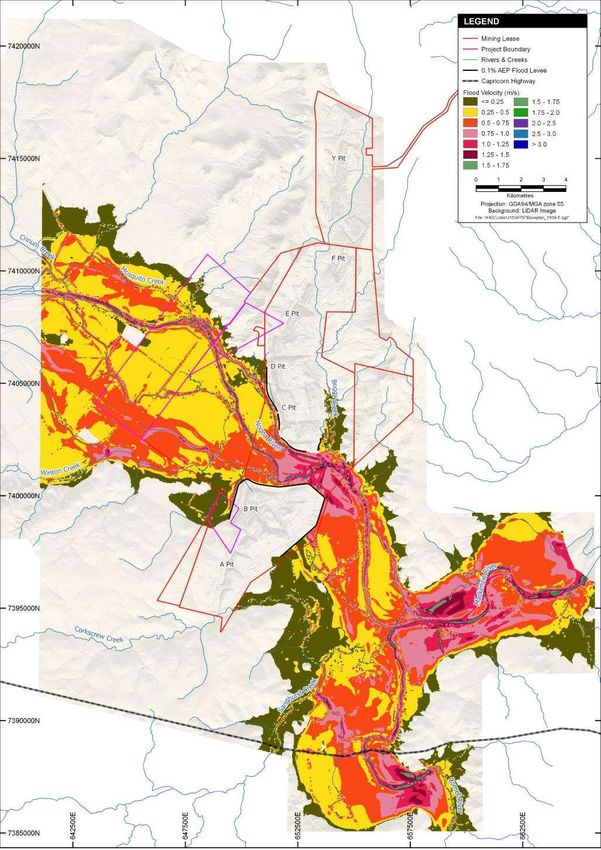
indicated in Figure 11-3 for a 1:1,000 (0.1 per cent AEP) year flood event.
The subsidence study also considered the effect of flooding the underground working post mining on the
strength of the pillar system.
The Subsidence Report found that in the longer term, flooding of the Project underground workings will occur
post closure when water is no longer pumped from the underground mine and the groundwater rebounds. The
subsidence study undertaken by Gordon Geotechniques (2020) assessed that flooding of mine workings could
influence pillar load in two ways:
1. The water pressure acting on the roof of the workings would function as a hydraulic jack to unload the
pillars or
2. The overburden may be fully saturated over the full water head, effectively reducing the density, resulting
in lower loads on the pillars.
ENSHAM LIFE OF MINE EXTENSION PROJECT ENVIRONMENTAL IMPACT STATEMENT 11-4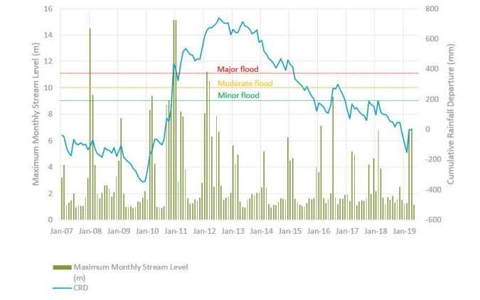
IDEMITSU AUSTRALIA RESOURCES

Both these mechanisms have a positive impact on the stability of underground bord and pillar workings.

11.4         Description of environmental values
11.4.1       Drainage characteristics
The main drainage feature in the Project Site is the Nogoa River. There are several significant upper tributaries
of the Nogoa River with the two of relevance to the Project being Theresa Creek and Crinum Creek, which
drain into the Nogoa River about 29 kilometres (km) and 21 km upstream of Ensham Mine respectively. The
Comet River drains into the Nogoa River about 8 km downstream of Ensham Mine. The Nogoa River and the
Comet River combine to form the Mackenzie River, which then becomes the Fitzroy River.
Fairbairn Dam was constructed on the Nogoa River 40 km upstream of the Theresa Creek confluence.
Releases are made from the dam to deliver supplies to downstream riparian water users and to maintain
supplies from Bedford and Bingegang weirs to various towns, mines and irrigators. Since the construction of
Fairbairn Dam in 1973, regulated releases are made to supply downstream users on most days.
Figure 11-1 shows the local drainage characteristics of the Nogoa River floodplain from the Theresa Creek
confluence to the Comet River confluence, which includes the Project Site. The Nogoa River drains through
the floodplain from west to east. There are also a number of flood channels across the floodplain that become
active as floodwaters rise. The most notable active channel is called the Anabranch, which is located
immediately to the east of Zone 1 of the Project Site.
The existing Ensham Mine has developed open-cut pits on the northern and southern sides of the Nogoa River
channel. The pits extend into the floodplain and are protected from flooding by earth levees as shown in
Figure 11-1. The levees provide flood protection for the open-cut pits (and underground mine portals) up to
the 0.1 per cent AEP event.
Two flood channels drain across the southern floodplain, one of which drains into Winton Creek. These flood
channels have been called Flood Channel 1 and 2 in this assessment and are likely paleochannels of the
Nogoa River. Another flood channel called Mosquito Creek drains along the northern floodplain downstream
of the Crinum Creek confluence.
Nogoa River within the reach consists of a well-defined 10 m deep channel that is carved through a relatively
flat floodplain channel. It is generally about 500 m wide from crest to crest to the adjacent floodplain except
adjacent to the Anabranch, where it narrows to about 300 m. Vegetation within the channel varies from very
mature eucalypts (demonstrating low rates of lateral movement) on the islands to immature trees and pioneer
species within the lower bench flood channels.
The Anabranch is slightly narrower than the main Nogoa River channel and is about 150 m wide and is also
slightly shorter and steeper. The Anabranch is characterised by a low flow channel that has a pool and riffle
sequence with a relatively defined lower bench and moderate bank slopes.
Flood Channel 1 consists of a broad and ill-defined channel adjacent to the Nogoa River and becomes more
defined as it drains into Winton Creek . The upper reaches are bound by floodplain infrastructure. The bed
gradient in Winton Creek is almost twice as steep as the upstream Flood Channel 1. However, water levels in
Winton Creek are significantly impacted by backwater flows from Nogoa River.
Flood Channel 2 consists of a well-defined channel that is up to 5 m deep and 40 m wide. It is bound by
floodplain infrastructure for much of its length.

ENSHAM LIFE OF MINE EXTENSION PROJECT ENVIRONMENTAL IMPACT STATEMENT                                       11-5
IDEMITSU AUSTRALIA RESOURCES

Mosquito Creek, which bifurcates from Crinum Creek, drains along a relatively incised valley that is about 5 m
deep and up to 200 m wide.
11.4.2       Floodplain characteristics
The Nogoa River floodplain varies in width from about 4 km at the location of Ensham Mine (currently narrowed
to 1.5 km by the mine levees) to about 13 km near the Crinum Creek confluence. The floodplain consists of
quaternary alluvium and lacustrine deposits of a mix of sand, silt, clay and gravel. Hansen Consulting (2006)
characterised the alluvium as a strongly structured alkaline heavy (cracking) clay soil classified as a grey or
brown vertosol soil. The soils are non-sodic but are moderately dispersive.
The alluvial soils are bound to the south by eroded sediments from the elevated Tertiary Emerald formation
and to the north-west by late tertiary colluvium and late Permian sandstone and silty sandstone at the location
of Ensham Mine.

ENSHAM LIFE OF MINE EXTENSION PROJECT ENVIRONMENTAL IMPACT STATEMENT                                     11-6
IDEMITSU AUSTRALIA RESOURCES

11.4.3       Existing flood conditions
The terrain in the Project Site is generally flat, with the area to the west of Ensham Mine a floodplain of the
Nogoa River, a tributary of the Fitzroy River. Fairbairn Dam was constructed on the Nogoa River upstream of
Emerald in 1973 and supplies water to various industrial, agricultural and residential users. The dam has
significantly changed the flow regime in the downstream reaches of the Nogoa and Mackenzie Rivers. A flood
event in December 2010/2011 event was the largest event to have been recorded since the Fairbairn Dam
was commissioned.
The Department of Natural Resources, Mines and Energy (DNRME) records flows in the Nogoa River at the
Duck Ponds gauging station (130219A). The Bureau of Meteorology classifies flood levels at the Duck Ponds
gauging station as minor, moderate and major for water level at respectively 9, 10 and 11 m above the riverbed.
According to this classification, January 2008 and December 2010 have been two major flood events and
January 2012 has been a moderate flood event. The latest flood event in July 2016 was minor.
The maximum monthly level for the Nogoa River, as recorded at the Duck Ponds gauging station 130219A,
against the cumulative rainfall departure (CRD) is shown in Figure 11-2 (refer to Figure 7, Appendix F-1
(Groundwater impact assessment)).

Figure 11-2 Maximum monthly level for Nogoa River plotted against cumulative rainfall departure

ENSHAM LIFE OF MINE EXTENSION PROJECT ENVIRONMENTAL IMPACT STATEMENT                                   11-8
IDEMITSU AUSTRALIA RESOURCES
As part of the hydrology and flooding assessment undertaken for the Project (Appendix E-3 (Hydrology and
flooding)), flooding behaviour such as inundation, flow depth and flow velocity in the Nogoa River have been
forecast based on previous flood modelling. The modelling considered the 10 per cent AEP, 5 per cent AEP,
1 per cent AEP and 0.1 per cent AEP maximum inundation areas and peak flow depths for existing conditions.
Flood modelling of the Nogoa River floodplain shows that:
The Anabranch is highly connected to the river receiving flows potentially multiple times per year
The flood channels would receive flows once every 5 to 10 years, on average when the main Nogoa River
channel overflows
The channel capacity, or the channel-forming flow of the Nogoa River is equivalent to an event between
the 18 per cent and 10 per cent AEP events
For the 10 per cent AEP event, the majority of flows are conveyed by the Nogoa River channel (54 per
cent) with the Anabranch conveying 36 per cent and Flood Channel 2 10 per cent. Very little flow is
conveyed by Flood Channel 1.
For the 1 per cent AEP event, Flood Channel 1 and 2 convey the majority of the flow (52 per cent) followed
by the main Nogoa River channel (26 per cent).
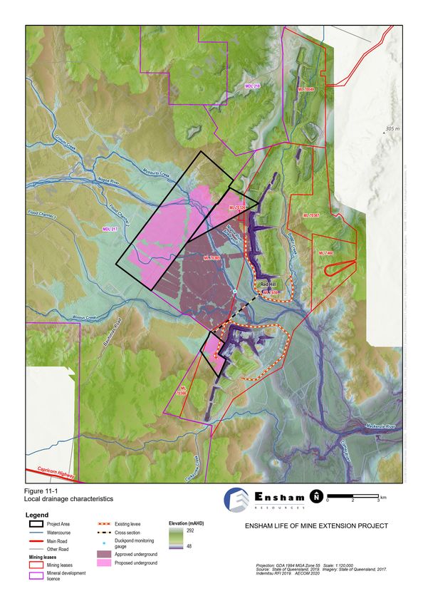
Figure 11-3 illustrates the maximum flood depth for the 0.1 per cent (1 in 1,000 year) AEP event for existing
conditions. Figure 11-4 illustrates the peak flow velocities for the 0.1 per cent (1 in 1,000 year) AEP event for
existing conditions. The range of flood scenarios are presented and discussed in Appendix E-3 (Hydrology
and flooding).
ENSHAM LIFE OF MINE EXTENSION PROJECT ENVIRONMENTAL IMPACT STATEMENT 11-9IDEMITSU AUSTRALIA RESOURCES Figure 11-3 Existing conditions flood depths for the 0.1 per cent (1 in 1,000 year) AEP event ENSHAM LIFE OF MINE EXTENSION PROJECT ENVIRONMENTAL IMPACT STATEMENT 11-10
IDEMITSU AUSTRALIA RESOURCES

Figure 11-4 Existing conditions peak flow velocities for the 0.1 per cent (1 in 1,000 year) AEP event

ENSHAM LIFE OF MINE EXTENSION PROJECT ENVIRONMENTAL IMPACT STATEMENT                              11-11
IDEMITSU AUSTRALIA RESOURCES

11.5         Potential impacts
11.5.1       Flooding Impacts
Flooding impacts as a result of the Project have been assessed by comparing the existing conditions against
the operational flood conditions. As no changes to the surface topography is predicted, the existing flood
conditions presented in Section 11.4.3 are considered applicable to the Project operational conditions and
hence remain unchanged from approved operations at the Ensham Mine. The flood modelling undertaken for
the Project is presented in Appendix E-3 (Hydrology and Flooding). The modelling shows the changes to the
existing and operational conditions as a result of the Project.
Overall, the Project is not expected to have any additional impact on the flows or flow regime of the Nogoa
River compared to existing approved operations. The model predictions for the existing operation and the
Project indicates that a similar annual extraction volume of between 600 ML and 700 ML is required in both
scenarios. This is less than the extraction allocation from the Nogoa River of 1500 ML/yr.
The Project does not require any materially additional surface infrastructure above what is already provided at
the existing Ensham Mine that may impact flood storage volumes. The Project is not expected to have a
significant impact on the flood regime. Impacts to flooding will be managed within the existing disturbance
areas at Ensham Mine. The existing surface infrastructure (flood levee) will be used to provide flood protection
from 1 in 1,000 year flood event, which is in accordance with the current EA. Furthermore, the analysis
indicates that there would not be additional flooding impacts at the Project Site as a result of the Project.
No assessment of regulated structures is made in this EIS as there are no regulated structures associated
with the Project.

11.5.2       Geomorphology Impacts
11.5.2.1     Potential changes in surface levels due to subsidence
Subsidence can alter surface gradients affecting in-stream velocities and the distribution of floodplain flow. In
high-subsidence areas this can potentially lead to a channel avulsion, where flow is directed to a new flow path
that becomes the main channel. The changes in flow velocity and distribution can affect surface water EVs
through increased erosion or sediment deposition.
The subsidence assessment found that there would be little or no (less than 40 mm) subsidence from the
Project. Predicted subsidence above the panel pillars following secondary coal recovery in the Project Site is
predicted to be less than 40 mm. This reduces to less than 20 mm above the bell out pillars (Gordon
Geotechniques, 2020). Subsidence of this magnitude would be undetectable because natural process such
as changes in vegetation, soil shrinkage or swelling due to variations in moisture content, or fluvial processes
of erosion and deposition could produce similar (or greater) variations in surface levels as recognised by the
Department of Agriculture, Water and the Environment (IESC, 2015).
This means that the Project is not predicted to cause any measurable surface subsidence that may alter water
flow, which is consistent with the surface monitoring (LiDAR) assessments across the existing underground
mine. The potential impacts of subsidence on surface water resources are discussed in Chapter 10 (Surface
water resources).

ENSHAM LIFE OF MINE EXTENSION PROJECT ENVIRONMENTAL IMPACT STATEMENT                                     11-12
IDEMITSU AUSTRALIA RESOURCES

11.5.2.2     Impacts of flood events on the underground bord and pillar network
The Project is proposed to be undertaken using bord and pillar mining with a minimum FoS of 1.6. This mining
system forms a regular array of stable coal pillars and roadways in each panel and does not cause large scale
overburden fracturing and subsidence. Between each panel large 35-40 m (solid) barrier panels (blocks of
coal) are left and are designed to minimise the interaction of overburden loads between the panels. Barrier
pillars between panels have a higher FoS, for example, a 35 m wide barriers at 180 m depth is 2.75. This
increases to 3.15 for the 40 m wide barrier pillars. Similarly, the 25 m solid barriers between the sub-panels
have minimum FoS values of 2.04 at 180 m depth of cover (i.e. FoS greater than the EA Condition G2
requirements).
In a 1:1,000 (0.1 per cent AEP) flood event, a temporary 10 m flood depth is predicted within the Nogoa River
channel above the Zone 1 bord and pillar mining area as indicated in Figure 11-3. Assuming a density for the
water of 1.1 t/m3 to conservatively allow for some sediment load, the increase in the effective depth of cover
for a 10 m deep flood would be 4.5 m. The temporary short term increase in density due to saturation of the
river alluvium was also be considered. The Nogoa River alluvium averages 20 m thick and when saturated is
assessed to have an upper bound density of 2.8 t/m3. This temporary increase in density equates to an
additional 2.9 m depth of cover and a total effective depth of cover increase of 7.4 m.
In this area, the Nogoa River flows over thicker Aries-Castor Seams (typically 5 - 5.2 m) in the shallower (130-
170 m) eastern part of Zone 1. In the deeper (170-190 m), western part of the area, the seam thins to 3 m.
The FoS of the pillars below the Nogoa channel has been conservatively assessed in the deepest parts of
these two areas where the pillar load is the highest. The upper bound seam thickness, flood depth and alluvium
density have also been assumed.
In the deeper western part of the area, increasing the depth of cover from 190 m to 197.4 m, above the standard
24 m by 28 m (centre dimension) pillars, temporarily decreases the FoS from 1.91 to 1.84, still significantly
above the minimum 1.6. Whilst mining in the eastern, shallower part of the area it is anticipated, based on
experience in the current underground workings, that 0.8 m of roof coal would be left in place. The maximum
pillar height would therefore be 4.4 m.
At 170 m depth of cover, the FoS for standard pillar configuration (24m x 28m) temporarily decreases in a
1:1,000 (0.1 per cent AEP) flood event to 1.42. As these FoS values are less than 1.6, the standard pillar
configuration will be increased to (26 m x 30 m) or the mining height would be reduced to ~3.87 m to ensure
the FoS is maintained above 1.6. This mining methodology has been shown to be effective in the current
Ensham underground workings in controlling the FoS (refer to “Increase in Pillar Load During a Flood Event”
memo (Gordon Geotechniques, 2021)).
Over the remainder of the flood plain, the predicted maximum flood depth is 2-4 m based on Figure 11-3. At
4 m flood depth, the increase in the effective depth of cover is 1.8 m. Similarly, the soil cover on the flood plain
is typically less than 2 m and when saturated would account for an additional 0.29 m depth of cover. The
temporary total effective depth of cover increase of 2.09 m over the flood plain is therefore not considered
significant based on the commentary above for flooding along the Nogoa River channel.
11.5.2.3     Loss of surface water through stream bed cracking caused by mine subsidence
Stream bed cracking can affect surface water EVs by reducing surface water flow volumes and diverting
surface water, along with potential contaminants, to groundwater.
Unlike longwall mining, pillars and barrier pillars will remain after mining to support the roof, with the mined
areas of the coal seam remaining as permanent voids (i.e. no goaf). With limited (less than 40 mm) subsidence
predicted, and as evident at the existing underground workings, no cracking of river / stream beds is predicted.

ENSHAM LIFE OF MINE EXTENSION PROJECT ENVIRONMENTAL IMPACT STATEMENT                                         11-13
IDEMITSU AUSTRALIA RESOURCES

The groundwater assessment (Appendix F-1) and subsidence assessment (Appendix B-2) concluded that
the Project will not increase the risk of streambed cracking and associated losses of baseflow to groundwater.
11.5.2.4     Surface infrastructure
Surface infrastructure such as roads, culverts, dams, conveyors or vent shafts can potentially interfere with
surface drainage and flood flows. Resulting changes in flow velocity and direction can potentially affect surface
water EVs through increased erosion or sediment deposition, or increased in flood levels.
As the Project is a continuation of the existing underground mining, using existing surface infrastructure located
on the existing approved mining leases (MLs) with additional minor flaring infrastructure, it is concluded that
existing and new infrastructure associated with the Project will not change surface flow regimes.

11.5.3       Impacts on environmental values
Based upon the above discussion. the Project will not cause any material change in flood velocities and shear
stresses from existing conditions because there will be no measurable change in ground surface levels. The
morphology of the river channel and floodplain, including the sediment transport characteristics and erosion
potential, will not be impacted by the Project. Therefore, impacts on surface water EVs relevant to
geomorphology as a result of the Project are considered unlikely.

11.6         Mitigation measures
As the Project is an extension of the current underground operations at Ensham Mine with no material changes
to site infrastructure, impacts to surface water flow are not considered to be significant. The management of
impacts to surface water is primarily achieved through the design of the site water management system.
The existing Ensham Mine already has a number of flood protection measures in place, including a flood levee
to protect the existing operations during the 0.1 per cent AEP (1 in 1,000 year) event. As no changes to the
surface topography are required, the existing flood conditions are expected to continue for the Project.
The final landform for the closure of the open cut voids will include landforms as approved in Appendix 3 of
the EA. The existing levees provide 1 in 1,000 (0.1 per cent AEP) flood event immunity, and hence will provide
protection to the portals and accordingly, the existing approved underground as well as the expanded workings
proposed for this Project.
Following closure of the open cut mine, the existing flood levees will be incorporated into the final landform
design, with overburden emplacement areas behind the levee being reshaped in a manner that achieves a
stable landform. This landform will provide protection to the final Ensham Mine landforms north and south of
the Nogoa River in perpetuity against flood events up to 0.1 per cent AEP plus 0.5 m.
The geotechnical assessment based on the proposed bord and pillar design and a 1.6 FoS does not predict
subsidence at the Project exceeding the natural 50 mm variation. Annual assessments will be conducted using
LiDAR to assess potential subsidence (recognising that none is predicted above natural variation). If LiDAR
data identifies differences in ground levels, an investigation will be conducted to verify the presence of
secondary evidence of subsidence as described in Chapter 8. A revision of the EA Condition G2 is provided
in Chapter 27 to monitor and investigate changes in surface levels above mined out areas.
Based on estimated additional loads under a potential 1 in 1,000 (0.1 per cent AEP) flood event where
temporary additional loading from flood waters within the main river channel may be expected, the pillar sizing
would be increased from 24 m x 28 m to 26 m x 36 m or the mining height reduced to 3.87 m to mitigate
additional loading under the river and maintain a minimum 1.6 FoS at the temporary effective 177.4 m depth

ENSHAM LIFE OF MINE EXTENSION PROJECT ENVIRONMENTAL IMPACT STATEMENT                                       11-14
IDEMITSU AUSTRALIA RESOURCES

of cover. No additional mitigation for mined areas under the floodplain with shallower flood depth is required
(refer to “Increase in Pillar Load During a Flood Event” memo (Gordon Geotechniques, 2021)).
The subsidence and groundwater assessments considered that groundwater levels will recover within the
underground workings following mine closure. This will happen gradually, as groundwater within the
surrounding coal seam flow, due to pressure differences, into the underground workings. The subsidence
assessment states that this will provide long-term stability and not result in changes to the overlying Nogoa
River and floodplain in the long-term.
The existing Ensham Mine currently manages impacts to water in accordance with the requirements of EA
EPML00732813. In accordance with condition G5 of the EA, Ensham Mine currently have measures in place
to ensure that dangerous goods and hazardous substances are stored in a secure manner to prevent loss of
containment during flooding events. As the Project is not expected to have any flooding impacts on water
values in the Project Site, no additional mitigation measures are proposed.
As there are no predicted geomorphological impacts as a result of the Project, no specific mitigation measures
are required.

11.7         Summary and conclusions
The assessment of flooding and geomorphology for the Project is based on hydraulic modelling undertaken
during previous studies at Ensham Mine.
The assessment also draws on the mine water balance assessment undertaken for the Project (Chapter 10
(Surface water resources)). The assessment demonstrates that, as the Project is an extension of existing
operations at Ensham Mine and requires no additional surface disturbance or infrastructure, the existing
flooding conditions are expected to remain unchanged.
The existing levees provide protection against flood events up to 0.1 per cent AEP plus 0.5 m in compliance
with the Ensham Mine EA conditions. The existing flood levees will be incorporated into the landform design,
with overburden emplacement areas behind the levee being reshaped in a manner that achieves a long-term
stable landform. This landform will provide protection against flooding of the underground workings through
the portals.
The geotechnical assessment did not predict subsidence for the Project that would exceed a 40 mm natural
variation under normal seasonal conditions. The assessment was based on a FoS of 1.6 for bord and pillars
under the river and in the floodplain.
The subsidence assessment also concluded that natural groundwater recovery of the underground workings
will have a positive impact on the stability, noting that the assessment also indicated the workings will remain
stable during mining when dry.
Ensham Mine’s existing water management system, which comprises water storages, water reticulation and
water release facilities, would be adequate to meet the operational requirements of the Project without
augmentation (HEC 2020). Potential changes to surface water flow and flooding, including the stability and
erosion of waterways, as a result of subsidence is not predicted. Therefore, the Project is not expected to have
any additional impact on the flows or flow regime of the Nogoa River compared to existing approved operations.

ENSHAM LIFE OF MINE EXTENSION PROJECT ENVIRONMENTAL IMPACT STATEMENT                                     11-15
You can also read