Colligan Mahon Catchment Assessment 2010-2015 - (HA 17) - Catchment Science & Management Unit Environmental Protection Agency
←
→
Page content transcription
If your browser does not render page correctly, please read the page content below
Colligan Mahon Catchment Assessment
             2010-2015
               (HA 17)

       Catchment Science & Management Unit

         Environmental Protection Agency
                 December 2018

                   Version no. 3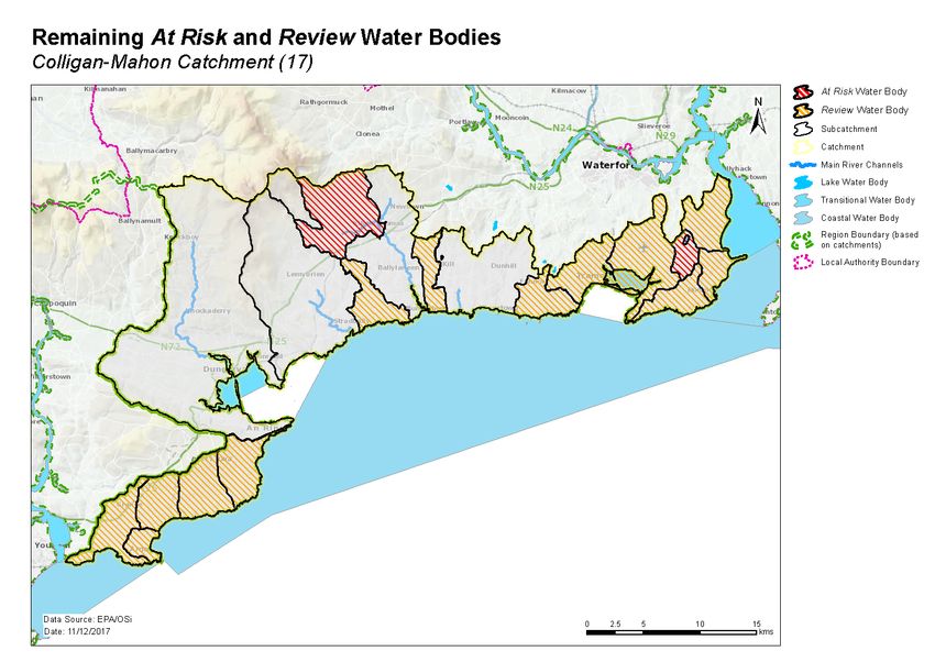
Preface
This document provides a summary of the characterisation outcomes for the water resources of the
Colligan Mahon Catchment, which have been compiled and assessed by the EPA, with the assistance of
local authorities and RPS consultants. The information presented includes status and risk categories of
all water bodies, details on protected areas, significant issues, significant pressures, load reduction
assessments, recommendations on future investigative assessments, areas for actions and
environmental objectives. The characterisation assessments are based on information available to the
end of 2015. Additional, more detailed characterisation information is available to public bodies on the
EPA WFD Application via the EDEN portal, and more widely on the catchments.ie website. The purpose
of this document is to provide an overview of the situation in the catchment and help inform further
action and analysis of appropriate measures and management strategies.
This document is supported by, and can be read in conjunction with, a series of other documents which
provide explanations of the elements it contains:

    1. An explanatory document setting out the full characterisation process, including water body,
       subcatchment and catchment characterisation.
    2. The Final River Basin Management Plan, which can be accessed on: www.catchments.ie.
    3. A published paper on Source Load Apportionment Modelling, which can be accessed at:
       http://www.jstor.org/stable/10.3318/bioe.2016.22
    4. A published paper on the role of pathways in transferring nutrients to streams and the relevance
       to water quality management strategies, which can be accessed at:
       http://www.jstor.org/stable/pdf/10.3318/bioe.2016.19.pdf
    5. An     article   on    Investigative   Assessments       which     can     be    accessed     at:
       https://www.catchments.ie/download/catchments-newsletter-sharing-science-stories-june-
       2016/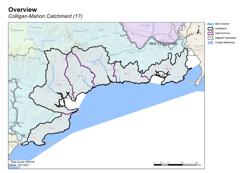
Table of contents
1     Introduction .......................................................................................................................... 1
2     Water body status and risk of not meeting environmental objectives ............................... 2
    2.1     Surface water ecological status ..................................................................................... 2
      2.1.1        Rivers and lakes ..................................................................................................................2
      2.1.2        Transitional and Coastal (TraC) .......................................................................................... 3
    2.2     Groundwater status....................................................................................................... 6
    2.3     Risk of not meeting surface water environmental objectives ...................................... 7
      2.3.1        Rivers and lakes ..................................................................................................................7
      2.3.2        Transitional and Coastal (TraC) .......................................................................................... 7
    2.4     Risk of not meeting groundwater environmental objectives ....................................... 8
    2.5     Protected areas ............................................................................................................. 9
      2.5.1        Drinking water protected areas ......................................................................................... 9
      2.5.2        Bathing waters ...................................................................................................................9
      2.5.3        Shellfish areas ....................................................................................................................9
      2.5.4        Nutrient sensitive areas .....................................................................................................9
      2.5.5        Natura 2000 sites ...............................................................................................................9
    2.6     Heavily modified water bodies .................................................................................... 11
3     Significant issues in At Risk water bodies .......................................................................... 11
4     Significant pressures........................................................................................................... 11
    4.1     Water bodies ............................................................................................................... 11
      4.1.1        Rivers, lakes, transitional and coastal (TraC) ...................................................................11
      4.1.2        Groundwater ....................................................................................................................12
    4.2     Pressure type ............................................................................................................... 12
      4.2.1        Agriculture ........................................................................................................................12
      4.2.2        Urban waste water treatment plants ..............................................................................12
      4.2.3        Domestic waste water .....................................................................................................13
      4.2.4        Other significant pressures ..............................................................................................13
      4.2.5        Forestry ............................................................................................................................13

5     Load reduction assessment ................................................................................................ 16
    5.1     River water body load reductions ............................................................................... 16
    5.2     TraC load reductions.................................................................................................... 17
6     Further characterisation and local catchment assessments ............................................. 18
7     Catchment summary .......................................................................................................... 18
8     Areas for Action .................................................................................................................. 19
    8.1     Process of Selection ..................................................................................................... 19
    8.2     Outcomes of process ................................................................................................... 19
9     Environmental Objectives .................................................................................................. 20
    9.1     Surface Water .............................................................................................................. 21
    9.2     Groundwater ............................................................................................................... 21
10 Acknowledgements ............................................................................................................ 24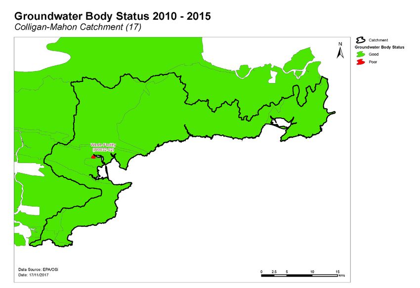
1   Introduction
This catchment includes the area drained by the Rivers Colligan and Mahon and all streams entering
tidal water between Cheekpoint and East Point, Co. Waterford, draining a total area of 665 km². The
largest urban centre in the catchment is Tramore. The other main urban centres are Dungarvan and
Dunmore East. The total population of the catchment is approximately 41,320, with a population density
of 62 people per km².

This is a coastal catchment, dominated by the sandstone uplands of the Monavullagh and Comeragh
Mountains. The southwestern region of the catchment to the south of Helvick Head is drained by a
series of small southerly flowing rivers including the Knockmeelmore, Ballylangadon, Addrigole,
Screathan and Maol and Choirnigh Rivers. The flat, karstified limestone-floored valley, to the west of
Dungarvan is drained by the Brickey River which flows into Dungarvan Harbour behind Cunnigar. There
are rich deposits of copper around the coast in this catchment and copper mining was historically
important in this area. An arterial drainage scheme was completed on the Brickey River by the OPW
between 1965 and 1967. The Colligan River drains the western flanks of the Monavullagh Mountains,
flowing south, through Dungarvan and into Dungarvan Harbour from where it reaches the sea between
Ballynacourty Point and Helvick Head.

The Dalligan River drains the southern tip of the Monavullagh Mountains, flowing south to the sea west
of Ballyvoyle Head. The eastern flanks of the Monavullagh Mountains are drained by the River Tay which
flows southeast and into the sea near Stradbally. The River Mahon rises close to the Summit plateau of
the Commeragh Mountains, flowing south and over Mahon Falls, before turning east and then south at
Kilmacthomas and finally flowing out to sea at Bunmahon. The eastern part of the catchment is drained
by a series of north-south flowing rivers including the Kilmurrin, Ballynagorkagh, Monloum and Corbally
Rivers, the last two of which reach the sea through Tramore Bay.

The Colligan Mahon catchment comprises six subcatchments (Table 1, Figure 1) with 35 river water
bodies, two lakes, six transitional and six coastal water bodies, and ten groundwater bodies.

Table 1. List of subcatchments in the Colligan Mahon catchment

                 Subcatchment ID                                   Subcatchment Name
 17_1                                                 Kilmurrin_SC_010
 17_2                                                 MONLOUM_SC_010
 17_3                                                 Mahon_SC_010
 17_4                                                 Tay_SC_010
 17_5                                                 Maoil_an_Choirnigh_SC_010
 17_6                                                 Colligan_SC_010

                                                  1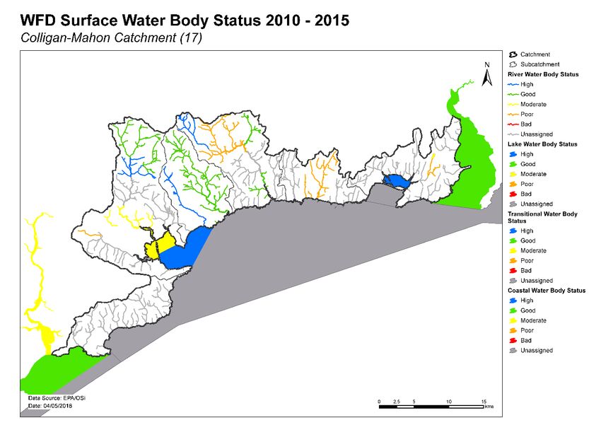
Figure 1. Subcatchments in the Colligan Mahon catchment

2   Water body status and risk of not meeting environmental objectives
2.1 Surface water ecological status
2.1.1   Rivers and lakes
♦ There were ten (27%) river and lake water bodies at Good or High status, and six (16%) at less than
  Good status in 2015 (Table 2, Figure 2). Twenty-one (57%) river and lake water bodies are
  unassigned.
♦ Four river water bodies and sites have a high ecological status objective. In 2015, three (75%) of
  these water bodies were at High status, and one was at Good (Figure 3, Appendix 1).
♦ The numbers of water bodies at each status class in 2007-09 and 2010-15 are shown in Figure 4
  (rivers). The Belle lake water body has remained at Moderate status throughout the cycles.
♦ Since 2007-09 when WFD monitoring began, one water body has an improved status whereas four
  have deteriorated (Figure 7).
♦ The variation in nutrient concentrations and loads in the Colligan and Mahon main channel is
  illustrated in Appendix 2.

                                                 2
2.1.2     Transitional and Coastal (TraC)
♦ There are 12 TraC water bodies in the Colligan Mahon catchment, five of which are transitional
  water bodies and seven are coastal. One transitional and two Coastal water bodies (Lower
  Blackwater M Estuary / Youghal Harbour, Youghal Bay and Western Celtic Sea (HAs 18;19;20)) are
  also shared with the Blackwater catchment.
♦ Five of the water bodies are at Good or High status (Dungarvan Harbour, Tramore Back Strand,
  Waterford Harbour, Barrow Suir Nore Estuary and Youghal Bay) and two (Lower Blackwater M
  Estuary/Youghal Bay and Colligan Estuary) are at less than Good status in 2015 (Table 2, Figure 5).
  Five water bodies are unassigned.
♦ Tramore Back Strand has a high ecological status objective. In 2015, it was at High status (Figure 3,
  Appendix 1).
♦ The numbers of water bodies at each status class in 2007-09 and 2010-15 are shown in Figure 5
  (TraCs).
♦ Note several of the TraC water bodies are shared with other catchments, HAs 13,19 and 20.
Table 2. Summary of surface water body status and risk categories

            Number                           2010-15 Status                           Risk Categories
            of water                                                             Not at                  At
             bodies     High    Good        Mod    Poor       Bad   Unassigned            Review
                                                                                  Risk                  Risk
 Rivers        35        3        7          1       4        0        20        10       18            7
 Lakes         2         0        0          1       0        0         1        0        1             1
 TraCs         12        2        3          2       0        0         5        5        4             3

Figure 2. Surface water ecological status

                                                         3
Figure 3. High ecological status objective water bodies and sites
River status over the WFD cycles
25
No. of Water Bodies
20
15
Unassigned
Unassigned
10
Moderate
Moderate
Good
Good
5
Poor
Poor
High
High
0
07-09 10-15
WFD Cycles and Status
Figure 4. Number of rivers at each status class in 2007-09 and 2010-15
4Transitional and Coastal water body status over the
WFD cycles
6
No. of Water Bodies
5
4
Unassigned
Unassigned
3
Moderate
Moderate
2
Good
Poor
Good
High
High
1
Bad
0
07-09 10-15
WFD Cycles and Status
Figure 5. Number of TraCs at each status class in 2007-09 and 2010-15
Figure 7. Surface water body status change from 2007-09 to 2010-15
52.2 Groundwater status
♦ There were nine groundwater bodies at Good status and one at Poor status in 2015 (Table 3, Figure
8). IE_SE_G_178 - Waste Facility (W0032-02) was classified at Poor status due to improved
information being available and the development of technical assessment approaches, rather than
there being deterioration in water quality in this water body between 2007-12 and 2010-15
♦ In 2007-12, all ten groundwater bodies were classed at Good status (Figure 6).
Table 3. Summary of groundwater body status and risk categories
2010-15 Status Risk Categories
Number of
water bodies Good Poor Not at Risk Review At Risk
Groundwater 10 9 1 3 5 2
Groundwater status over the WFD monitoring cycles
12
No. of water bodies
10
8
6
Good
4 Good
Poor
Poor
2
0
07-12 10-15
Monitoring cycles and status
Figure 6. Number of groundwater bodies at each status class in 2007-12 and 2010-15
Figure 8. - Groundwater body status 2010-2015
62.3 Risk of not meeting surface water environmental objectives
2.3.1 Rivers and lakes
♦ There are ten Not at Risk river and lake water bodies (Figure 9, Table 2) and these require no
additional investigative assessment or measures to be applied, other than those measures that are
already in place.
♦ There are 19 river and lake water bodies in Review for which more information is required.
♦ Eight surface water bodies in the catchment are At Risk of not meeting their water quality
objectives. Measures will be needed in these water bodies to improve the water quality outcomes.
Summary information for the At Risk water bodies is given in Appendix 3.
2.3.2 Transitional and Coastal (TraC)
♦ There are five TraC water bodies (Dungarvan Harbour, Tramore Bay, Eastern Celtic Sea (HAs 13;17),
Tramore Bay, Western Celtic Sea (HAs 18;19;20) Barrow Suir (HA16) and Barrow Suir Nore Estuary)
which are Not at Risk (Figure 9) and therefore require no additional investigative assessments or
measures to be applied, other than those measures that are already in place.
♦ Four TraC water bodies (Waterford Harbour, Tramore Back Strand, Brickey Estuary and Mahon
Estuary) are in Review.
♦ The remaining three TraC water body in the catchment (Colligan Estuary, Lower Blackwater M
Estuary / Youghal Harbour and Youghal Bay) are At Risk of not meeting their water quality objectives.
Measures will be needed in these water bodies to improve the water quality outcomes.
Figure 9. Surface water body risk
72.4 Risk of not meeting groundwater environmental objectives
♦ Three groundwater bodies are Not at Risk (Figure 10, Table 3) and require no additional investigative
assessment or measures to be applied, other than those measures that are already in place.
♦ Five groundwater bodies are in Review. Ballyknock is hydrologically linked to surface waters that are
not meeting water quality objectives where it is considered likely that groundwater is a contributing
source of nutrients (Figure 10, Table 5). All five groundwater bodies (Ballyknock, Dungarvan, Helvick
Head, Glenville and Tourig Group 3) have elevated nitrate concentrations.
♦ There are two At Risk groundwater bodies. Tramore is hydrologically linked to surface waters that
are not meeting water quality objectives where it is considered likely that groundwater is a
contributing source of nutrients (Table 5). Waste Facility (W0032-02) IE_SE_G_178 has ammonia
issues. Measures will be needed in both water bodies to improve water quality outcomes.
Figure 10. Groundwater body risk
Table 4. Summary of At Risk surface water bodies where phosphate from groundwater may contribute
to an impact.
Groundwater body Receiving water
Receiving water body name
name body code
Tramore IE_SE_17D020300 DUNHILL_010
82.5 Protected areas
2.5.1 Drinking water protected areas
♦ There are 52 abstractions in the Colligan Catchment, comprising one group water scheme, 37 public
supply schemes and nine private supply schemes.
♦ Forty-seven of the abstractions are from six groundwater bodies (Dungarvan, Glenville, Helvick
Head, Kilrion, and Tramore); and five are from five river water bodies (Mahon_040, Mahon_030,
Ballyvaden str_010, Tay_030 and Maoil_an_Choirnigh_010). The list of the public supplies and the
associated water bodies is provided in Appendix 4.
♦ There was one drinking water source that was non-compliant with the standards for nitrate in 2015
– Tramore groundwater body. All other sources were compliant.
♦ All drinking water sources were compliant with the standards for pesticides in 2015.
2.5.2 Bathing waters
♦ There are six designated bathing waters in the catchment.
♦ Four of the bathing waters are in satisfactory condition.
♦ The remaining two (Ardmore Beach and Bunmahon Beach) failed to meet their environmental
objectives, due to bacteriological water quality.
♦ The list of the bathing waters and the associated water bodies is provided in Table 5.
2.5.3 Shellfish areas
♦ There are two designated shellfish areas in the catchment (Dungarvan Harbour and Waterford
Harbour (Cheekpoint/ Arthurstown/ Creadan).
♦ They are compliant with the relevant standards and there are no water quality issues of concern.
♦ Details on the shellfish areas and their associated water bodies are summarised in Table 6.
2.5.4 Nutrient sensitive areas
♦ There are no nutrient sensitive areas in the catchment.
2.5.5 Natura 2000 sites
♦ There are six Special Areas of Conservation (SACs) in the catchment (Appendix 5). However, these
SACs do not have water quality and/or quantity conservation objectives for their qualifying
interests.
♦ There are four Special Protected Areas (SPAs) in the catchment:
o Dungarvan Harbour SPA (004032)
o Helvick Head to Ballyquin SPA (004192)
o Mid-Waterford Coast SPA (004193)
o Tramore Back Strand SPA (004027)
As there are no specific water quality and quantity supporting conditions identified in the site-
specific conservation objectives for these SPAs, the intersecting water bodies are not assigned
priority action for WFD protected area purposes in the second cycle.
9Table 5. Designated bathing waters in the catchment
Bathing Water Water Body Intersection Objective met? Comment Objective met?
Comment
Name Code Name Code Yes No
Ardmore Beach IESEBWC050_0000_0100 Eastern Celtic Sea (HAs 13;17) IE_SE_050_0000 Sufficient quality for 2012-2015.Less than
Good quality E.coli, 95th percentile: 900
and 90th percentile: 428. IE results are just
failing Good quality, 95th percentile: 211
and 90th percentile: 105. Returned to
Sufficient in 2015.
Ardmore returned to ‘Sufficient’ in 2015
assessment. Several high results in 2014
were due to sewage effluent disinfection
system failures. A new WWTP
commissioned in Q1 2016 is likely to lead to
status improvements or, as a minimum,
classification as ‘Changes’
Bunmahon Beach IESEBWC050_0000_0200 Eastern Celtic Sea (HAs 13;17) IE_SE_050_0000 Sufficient quality for 2012-2015.Less than
Good Quality E.coli, 95th percentile: 589
and 90th percentile: 316. Excellent quality
IE results, 95th percentile: 97 and 90th
percentile: 53. Comparable performance in
2016 should meet Good quality.
Counsellors' Strand, Dunmore IESEBWC100_0000_0100 Waterford Harbour IE_SE_100_0000
East
Dunmore Strand, Dunmore East IESEBWC100_0000_0200 Waterford Harbour IE_SE_100_0000
Tramore Beach IESEBWC110_0000_0100 Tramore Bay IE_SE_110_0000
Clonea Beach IESEBWC140_0000_0100 Dungarvan Harbour IE_SE_140_0000
10Table 6. Designated shellfish areas in the catchment
Shellfish area Water body intersection Objective met?
Name Code Name Code Yes No
Dungarvan Harbour IEPA2_0045 Colligan Estuary IE_SE_140_0100
Dungarvan Harbour IE_SE_140_0000
Waterford Harbour IEPA2_0056 Barrow Suir Nore Estuary IE_SE_100_0100
(Cheekpoint/Arthurstown
/Creadan) Waterford Harbour IE_SE_100_0000
2.6 Heavily modified water bodies
♦ There are no designated heavily modified water bodies (HMWB) in the catchment.
♦ There are no designated artificial water bodies (AWB) in the catchment.
3 Significant issues in At Risk water bodies
♦ Excess ammonia and phosphate leading to eutrophication are the dominant issues in rivers and
lakes in Colligan Mahon Catchment. While pollution from organic matter is also a concern, this is
only for a limited number of water bodies. Hydromorphological pressures were not identified for
this catchment.
♦ Nitrates and excessive nutrients are the significant issue for TraC water bodies in the Colligan Mahon
Catchment.
♦ Of the ten groundwater bodies, two are At Risk. Phosphates are an issue in one of the groundwater
bodies, which is likely to be a contributing source of nutrients to surface water bodies that are not
meeting water quality objective. Ammonia from the waste site Waste Facility (W0032-02)
IE_SE_G_178 is also an issue in a groundwater body.
4 Significant pressures
4.1 Water bodies
♦ Where water bodies have been classed as At Risk, by water quality or survey data, significant
pressures have been identified.
♦ Figure 11 shows a breakdown of the number of At Risk water bodies in each significant pressure
category.
4.1.1 Rivers, lakes, transitional and coastal (TraC)
♦ Significant pressures have been identified through the initial characterisation process, in 11 surface
water bodies, two of which have multiple pressures. The significant pressures will be refined as
further characterisation is are carried out.
♦ The significant pressure affecting the greatest number of river and lake water bodies is agriculture,
followed by urban waste water, domestic waste water, other, and forestry (Figure 11).
♦ The significant pressure affecting the greatest number of TraC water bodies is agriculture, followed
by urban waste water (Figure 11).
114.1.2 Groundwater
♦ The significant pressure affecting the Waste Facility (W0032-02) IE_SE_G_178 groundwater body is
the waste facility W0032-02. The key parameter of concern is ammonia. The significant pressure
affecting Tramore groundwater body is domestic waste water, which is causing phosphate issues.
Significant pressures in At Risk water bodies
7
6
5
No. of water bodies
4 Groundwater
Transitional
Coastal
3
Lakes
Rivers
2
1
0
Agriculture Urban Waste Domestic Waste Other Forestry
Water Water
Figure 11. Significant pressures impacting on At Risk water bodies
4.2 Pressure type
4.2.1 Agriculture
♦ Agriculture is a significant pressure in one lake (Belle lake), three river water bodies (Leperstown
Stream_010, Tay_010 and Brickey_010), one transitional water body (Lower Blackwater M Estuary
/ Youghal Harbour) and one coastal water body (Youghal Bay) (Figure 12). The issues related to
farming in this catchment are phosphorus loss to surface waters from, for example, direct
discharges; or runoff from yards, roadways or other compacted surfaces, or runoff from poorly
draining soils, resulting in excess nutrients in surface waters. The pollution impact potential map
showing areas of relative risk for phosphorus loss from agriculture to surface water is given in
Appendix 6.
4.2.2 Urban waste water treatment plants
♦ Urban Waste Water Treatment Plants (WWTPs) and agglomeration networks have been highlighted
as a significant pressure in three At Risk water bodies; details are given in Table 7 and Figure 13.
Kilmacthomas WWTP, which impacts Mahon_020, was due to be upgraded in 2016.
12Table 7. Waste Water Treatment Plants and agglomerations identified as Significant Pressures in At Risk
water bodies and expected completion dates for associated upgrade works, where applicable.
Expected
2010-15 Completion Date
Facility name Facility Type Water Body Ecological Status
Kill Kilmurrin Cove
A0380 < 500 p.e. Stream_010 Unassigned N/A 1
Kilmacthomas 1,001 to 2,000
D0275 p.e. Mahon_020 Poor 2016
Dungarvan Colligan
D0017 > 10,000 p.e. Estuary 2 Moderate N/A 1
4.2.3 Domestic waste water
♦ Domestic waste water has been identified as a significant pressure in two river water bodies
(Dunhill_010 and Brickey_010) and one groundwater body (Tramore) (Figure 14). This is due to a
concentration of unsuitable domestic waste water treatment systems and unlicensed discharges in
close proximity to the water bodies. The significant issues are a combination of excess nutrients
entering surface waters and microbiological contamination. Furthermore, several septic tank
systems are mapped in areas of karst.
4.2.4 Other significant pressures
♦ Unknown Anthropogenic
Collgan_040 is an At Risk water body which has unknown anthropogenic pressures (Figure 15).
♦ Waste
The significant pressure affecting the Waste Facility (W0032-02) IE_SE_G_178 groundwater body is
the waste facility W0032-02 (Figure 15).
4.2.5 Forestry
♦ Forestry has been identified as a significant pressure in the Tay_010 river water body (Figure 16).
The significant activity is clearfelling, with an area felled in relatively close proximity to the
monitoring point during 2010-12 monitoring, which has resulted in heavy siltation and excess
nutrients in the surface water body.
1Currently not specified in improvement plans.
2The Dungarvan agglomeration network, rather than the WWTP, has been identified as a pressure impacting the Colligan
Estuary.
13Figure 12. Water bodies that are At Risk and are impacted by agricultural activities
Figure 13. Water bodies that are At Risk and are impacted by urban waste water
14Figure 14. Water bodies that are At Risk and are impacted by domestic waste water
Figure 15. Water bodies that are At Risk and are impacted other anthropogenic pressures
15Figure 16. Water bodies that are At Risk and are impacted by forestry activities 5 Load reduction assessment 5.1 River water body load reductions ♦ The results of the main channel assessment for the Colligan-Mahon catchment indicate that orthophosphate is moderately low along the Mahon main channel and TON concentrations increase steadily downstream (Appendix 2). ♦ For water bodies where phosphorus monitoring data are available, the reduction in P load that would be required to bring the mean concentration back to the EQS of 0.035 mg/l as P, can be estimated using a simple method based on the average 2013 to 2015 concentration and the average flow, or the estimated 30th percentile flow (Q30) where flow data are not available. The relative load reductions are ranked on a national scale from Very High (>1 kg/Ha/y), to High (0.5-1 kg/Ha/y), to Medium (0.25-0.5 kg/Ha/y) to Low (
Table 9. Relative load reductions required in monitored water bodies that are At Risk.

                             Water body                                  P Load Reduction Required

 Kilmurrin Cove Stream_010                                                         Low
♦ The nitrate assessment is aimed at reducing the nitrate loading to the associated TraC water bodies.
  For water bodies where nitrate monitoring data are available, the reduction in TON load that would
  be required to bring the annual concentrations back to 2.60 mg/l can be estimated.
♦ In the Colligan-Mahon catchment, the available data indicate that N load reductions are required in
  13 river water bodies (Table 10).
Table 10. Relative load reductions required in monitored water bodies.

                     Water body                                 N Load Reduction Required
  COLLGAN_040                                                             High
  BRICKEY_020                                                             High
  MAHON_020                                                               High
  TAY_030                                                                 High
  COLLIGAN_020                                                            High
  MAHON_030                                                               High
  DUNHILL_010                                                             Med
  BRICKEY_010                                                             High
  MAHON_040                                                               Med
  KILMURRIN COVE STREAM_010                                               Med
  TAY_010                                                                 Low
  ARAGLIN (COLLIGAN)_010                                                  Low
  MAHON_010                                                               Low

5.2 TraC load reductions
Some 18 estuaries in Ireland have been monitored on a continual basis since 1990 as part of Ireland’s
commitment under the Convention for the Protection of the Marine Environment of the North-East
Atlantic (the Ospar Convention). This has shown that generally over the long term, nutrients have
decreased but further reduction will be required in many cases to support Good Ecological Status.
However, many estuaries have not been monitored to the same degree, and where monitoring data in
insufficient, an ongoing programme of modelling has been undertaken to estimate potential nutrient
load removal from contributing sub-catchments.

Different estuaries may require reductions in different nutrients. Further modelling work is required to
determine precisely what load reductions are required, but in the interim, further monitoring will be
carried out to assess the improvements resulting from various planned measures, and to confirm the
nature of the issues.

♦ The Colligan Estuary is impacted by excess nutrients which are derived from the lower reaches of
  the Colligan (Colligan_040) and the agglomeration network issues in Dungarvan. The estuary is N
  limited which indicates that reductions in nitrogen loads will be required. However, the estuary can
  also be P limited in summer. Estuarine modelling has not been carried out and therefore the extent
  of the load reduction that is required cannot be estimated. However, as a first step, reduction of N
  losses through remediation of the network issues, and reductions of nutrients generally from the
  Colligan River catchment, particularly Colligan_040, should be carried out.

                                                  17
♦ The Brickey Estuary which is connected to the Colligan Estuary is unmonitored and is therefore in
Review. Based on visual evidence it is highly likely that the estuary has water quality issues that are
like the Colligan estuary. The inflowing Brickey River also has elevated nutrients derived largely from
agricultural practices. Further monitoring is required.
♦ Load reductions for the Lower Blackwater M Estuary / Youghal Harbour and Youghal Bay are
outlined in the Blackwater Catchment Assessment.
6 Further characterisation and local catchment assessments
♦ Further characterisation through local catchment assessments is needed in eight of the At Risk
water bodies to refine the understanding of the significant pressures at the site/field scale so that
specific and targeted measures can be identified.
♦ Further characterisation through local catchment assessments is needed in 19 of the Review water
bodies to refine the understanding of the significant pressures at the site/field scale so that specific
and targeted measures can be identified.
♦ Brief definitions on the 10 IA assessment scenarios are given in Appendix 7.
Table 11. Local catchment assessment allocation for At Risk and Review river and lake water bodies in
the catchment
Risk IA 1 IA 2 IA 3 IA 4 IA 5 IA 6 IA 7 IA 8 IA 9 IA 10 Total
At 2 2 0 1 2 0 1 1 0 0 9
Risk
Revie 0 1 16 0 1 2 1 0 0 0 21
w
Note water bodies may have multiple categories of Local Catchment Assessments
7 Catchment summary
♦ Of the 37 rivers and lake water bodies, eight are At Risk of not meeting their WFD objectives.
♦ Excess ammonia and phosphate are the dominant issues in rivers and lakes in Colligan Mahon
Catchment, which are likely to be attributed to pressures that include agriculture, urban waste
water, domestic waste water and forestry. While pollution from organic matter is also a concern,
this is only for a limited number of water bodies.
♦ There are three At Risk transitional water bodies – the Colligan Estuary, Lower Blackwater M Estuary
/ Youghal Harbour and Youghal Bay. Nitrates and excessive nutrients are the significant issues in this
catchment. The Lower Blackwater M Estuary / Youghal Harbour and Youghal Bay are shared with
the Blackwater catchment.
♦ There are two At Risk groundwater bodies – IE_WE_G_0084, Waste Facility (W0032-02) due to
ammonia, and Tramore due to phosphates that have the potential to impact on associated At Risk
surface water bodies.
188 Areas for Action
The characterisation outcomes described above have highlighted that there is significant work to do in
the catchment to protect and restore water quality, and meet the objectives of the WFD. During the
development of the draft river basin management plan it became apparent that there would be a need
to prioritise areas for collective action so that the best return on investment could be achieved. 190
Areas for action have been selected nationally in a process as described below. There are three areas
for action in the Colligan/Mahon catchment.
8.1 Process of Selection
Following the publication of the draft river basin management plan in early 2017, the EPA and the Local
Authority Waters and Communities Office (LAWCO) jointly led a collaborative regional workshop
process to determine where, from a technical and scientific perspective, actions should be prioritised in
the second cycle. The prioritisation process was based on the priorities in the draft river basin
management plan, the evidence from the characterisation process, and the expertise, data and
knowledge of public body staff with responsibilities for water and the different pressure types. The
recommended areas for action selected during the workshops were then agreed by the Water and
Environmental Regional Committees. Since this selection, the Local Authorities Water and Communities
Office (LAWCO) have undertaken public engagement and feedback sessions in each local authority.
The recommended areas for action are an initial list of areas where action will be carried out in the
second cycle. All water bodies that are At Risk still however, need to be addressed. As issues are
resolved, or when feedback from the public engagement process is assessed, areas for action may be
removed from the list and new areas will be added. If additional monitoring shows that new issues have
arisen, new areas may become a priority and may need to be added to the work programme.
The initial list of areas for action is not therefore considered as a closed or finite list; it simply represents
the initial areas where work will be carried out during the second WFD planning cycle from 2018 to
2021.
8.2 Outcomes of process
The outcomes for the Colligan Mahon catchment are summarised below.
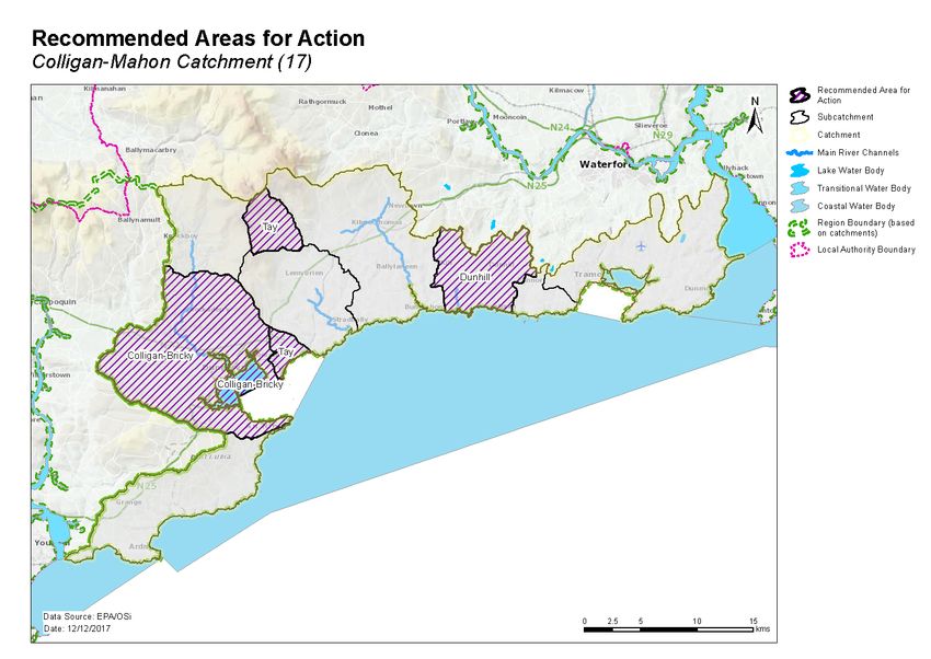
♦ Three recommended areas for actions (Table 12, Figure 17) were selected.
♦ These are the Colligan-Bricky, Tay, and Dunhill.
♦ These include:
• 10 river water bodies – five At Risk and five Review, and
• Two transitional water bodies – one At Risk and one Review.
♦ Two groundwater bodies, that are At Risk or Review due to groundwater contribution of
nutrients to surface water bodies, intersect with three of the recommended areas for action,
see Table 13. Actions taken to improve surface water will need to take account of the
groundwater contribution to surface water.
A remaining 22 At Risk and Review surface water bodies were not included in the recommended areas
for action for the second cycle. The distribution of these is presented in Figure 18. These include:
♦ 17 river and lake water bodies – three At Risk and 14 Review, and
♦ Five transitional water bodies – two at risk and three review
Table 12. Recommended Areas for Action in the Colligan Mahon catchment
19Number
Recommended Local
of water SCs Reason for Selection
area for action authority
bodies
• One deteriorated water body that is discharging into
Colligan estuary (moderate status).
• One Poor status water body that is discharging into
Bricky estuary, an estuary where macroalgae is increasing.
• Opportunity to build on existing knowledge of Inland
Fisheries Ireland and Irish Water regarding two unlicensed
discharges from pumping stations at Moate and
Colligan-Bricky 8 17_6 Waterford
Ballynagaul in Killongford_010 into Dungarvan Harbour
shellfish area.
• Important fisheries (sea trout, sea bass, oyster industry).
• Important for birds (SPA).
• Active CLAMs (coordinated local aquaculture
management) group in Newry.
• Important habitat for natural oyster beds.
• Discharges into popular bathing area (Stradbally)
• Discharges into an important sea bass fishery
Tay 2 17_4 Waterford • One deteriorated High Ecological Status objective water
body.
• One potential 'quick win'.
• Building on work completed by Waterford County
Council.
• Discharges into green coast bathing area.
• Potential to coordinate with recent work: Integrated
Dunhill 2 17_1 Waterford
Constructed Wetland development, local community work
to naturalise stream and biodiversity study completed by
Irish Water.
• One deteriorated water body.
Table 13 Groundwater bodies intersecting with surface water bodies in Recommended Areas for Action
Groundwater bodies Intersecting surface water bodies Recommended Area
Code Name Risk Code Name for Action
IE_SE_G_014 Review IE_SE_17C010300 COLLGAN_040
IE_SE_G_014 Review IE_SE_17C010300 COLLGAN_040 Colligan-Bricky
Ballyknock
IE_SE_G_014 Review IE_SE_17D030100 DEELISH STREAM_010
IE_SE_G_014 Review IE_SE_17C390620 CUSHCAM_010 Tay
IE_SE_G_146 At risk IE_SE_17D020300 DUNHILL_010
Tramore KILMURRIN COVE Dunhill
IE_SE_G_146 At risk IE_SE_17K030200
STREAM_010
9 Environmental Objectives
The environmental objectives are the target status for each At Risk or Review water body and the date
by which that status is expected to be achieved (Appendix 3). Where a water body is Not at Risk and is
already at its target status, the environmental objective is deemed to have been met.
209.1 Surface Water
♦ Assuming resources are available and actions are taken in the recommended areas for action, of
the six At Risk surface water bodies, it is predicted that 1 (17%) will improve by 2021 and 5 (83%)
will achieve their objective by 2027. For the six Review surface water bodies, the absence of
information on these water bodies means that there is no scientific basis to quantify an
environmental objective date and therefore a 2027 date is set, see Table 14.
Table 14. Environmental objective dates for water bodies in the Recommended Areas for Action
Risk Category No. of Water No. of WBs for 2021 No. of WBs for
Bodies Improvement 2027 Status
Improvement
Rivers
At Risk 5 1 4
Review 5 0 5
TraC
At Risk 1 0 1
Review 1 0 1
Total 12 1 11
♦ Fifteen surface water bodies have met their 2015 environmental objective. Two of the 15 water
bodies met their environmental objective for ecological status but failed to meet their protected
area objectives.
♦ As action is not yet planned to be taken in four of the remaining five At Risk surface water bodies, a
2027 date is applied to all four water bodies. Due to planned upgrade works at an urban waste
water treatment plant, a 2021 objective is applied to the fifth At Risk water body.
♦ For the 17 Review surface water bodies, the absence of information on these water bodies means
that there is no scientific basis to quantify an environmental objective date and therefore a 2027
date is set, see Table 15.
Table 15. Environmental objectives dates in the At Risk and Review surface water bodies not included
in Recommended Areas for Action
Risk Category No. of Water Bodies No. of WBs for 2021 No. of WBs for 2027
Improvement Status Improvement
Rivers
At Risk 2 1 1
Review 13 0 13
Lakes
At Risk 1 0 1
Review 1 0 1
TraCs
At Risk 2 0 2
Review 3 0 3
Total 22 1 21
9.2 Groundwater
♦ Nine of the ten groundwater bodies are currently Good status and, therefore, have met their
environmental objectives.
♦ The one groundwater body, Waste Facility (W0032-02), in the Colligan Mahon catchment that is
less than Good status has an environmental objective date of 2027.
21Figure 17. Location of Recommended Areas for Action in the Colligan Mahon Catchment
Figure 18. Location of At Risk and Review water bodies located outside Recommended Areas for Action in the Munster Blackwater Catchment
10 Acknowledgements
The Colligan Mahon Catchment Assessment (Version 3) has been produced by the Catchment Science
& Management Unit, EPA, with the assistance of the following:

   •   Waterford City and County Council
   •   Cork County Council.
   •   Tipperary County Council.
   •   Inland Fisheries Ireland.
   •   Local Authorities Waters & Communities Office.
   •   Irish Water.
   •   RPS Group.
   •   Ecological Monitoring & Assessment Unit, EPA.
   •   Hydrometric & Groundwater Section, EPA.
   •   Informatics Section, EPA.
   •   Laboratories, EPA.
   •   Office of Environmental Enforcement, EPA.
   •   Department of Housing, Planning and Local Government.
   •   DAFM Agriculture.
   •   DAFM Forest Service.
   •   Coillte.
   •   Teagasc.
   •   Geological Survey Ireland.
   •   National Federation of Group Water Schemes.
   •   National Parks and Wildlife Service.
   •   Board Iascaigh Mhara.
   •   Marine Institute.
   •   Sea Fisheries Protection Authority.
Appendix 1 High ecological status objective water bodies and sites
 Water body/ Site      Type                 Codes             2015 Status
 COLLIGAN_020          River                IE_SE_17C010150   High
 DALLIGAN_010          River                IE_SE_17D010300   High
 MAHON_010             River                IE_SE_17M010100   High
 TAY_010               River                IE_SE_17T010050   Good
 Tramore Back Strand   Coastal water body   IE_SE_120_0000    High
Appendix 2 Catchment scale nutrient concentrations and in-stream loads
The results of the in-stream water quality assessment for the Colligan and Mahon main channels are
illustrated in Chart 1. Orthophosphate results in the Colligan main channel increase from 0.08 to
0.012mg/l downstream and remain well below the EQS for good status (0.035mg/l). Only two of the
four Colligan main channel water bodies have chemistry data associated with them. The
orthophosphate concentrations throughout the Mahon main channel are also moderately low and
range from 0.005 to 0.030mg/l.

Ammonia concentrations in the Colligan main channel increase from 0.020 to 0.054mg/l, and remain
below the EQS for good status (0.065mg/l). Along the Mahon main channel, ammonia concentrations
show a significant spike at Mahon_020, exceeding the EQS and decreases downstream to below the
EQS.

TON concentrations along the Colligan main channel increase downstream, but remain below the
2.6mg/l threshold value. The TON concentrations along the Mahon main channel become elevated from
Mahon_020 above the threshold and increase steadily downstream.

The nutrient loadings, as shown in Chart 2, show similar trends to the concentrations trends in Chart 1.

                                          Chart 1: Colligan and Mahon Main Channel Nutrients
                                   0.10                                                                                                                 3.5
                                   0.09
  Ortho-P & Total Ammonia (mg/l)

                                                                                                                                                              Total Oxidised Nitrogen (mg/l)
                                                                                                                                                        3.0
                                   0.08
                                   0.07                                                                                                                 2.5

                                   0.06
                                                                                                                                                        2.0
                                   0.05
                                                                                                                                                        1.5
                                   0.04
                                   0.03                                                                                                                 1.0
                                   0.02
                                                                                                                                                        0.5
                                   0.01
                                   0.00                                                                                                                 0.0
                                           COLLIGAN_010

                                                          COLLIGAN_020

                                                                         COLLIGAN_030

                                                                                        COLLGAN_040

                                                                                                        MAHON_010

                                                                                                                    MAHON_020

                                                                                                                                MAHON_030

                                                                                                                                            MAHON_040

                                          Orthophosphate                                Total Ammonia               Total Oxidised Nitrogen
Chart 2: Colligan Main Channel Nutrient Loading
6000 250,000
Ortho-P & Total Ammonia (Kg/yr)
Total Oxidised Nitrogen (Kg/yr)
5000
200,000
4000
150,000
3000
100,000
2000
50,000
1000
0 0
COLLIGAN_010
COLLIGAN_020
COLLIGAN_030
COLLGAN_040
MAHON_010
MAHON_020
MAHON_030
MAHON_040
P Load (Kg/yr) Ammonia Load (Kg/yr) TON Load (Kg/yr)Appendix 3 Summary information on At Risk and Review surface water bodies
High
Ecological
Status
Ecological Ecological Objective Date to Meet Recommended
Subcatchment Water body Water Status Status Water Significant Environmental Area for Action
code code Water body name body type Risk 07-09 10-15 Body Y/N Pressures Objective Name
17_1 IE_SE_17_6 Ballinlough Lake Review Unassigned Unassigned N 2027
17_1 IE_SE_17F070820 Fennor_North_010 River Review Unassigned Unassigned N 2027
17_1 IE_SE_17K030200 Kilmurrin Cove Stream_010 River At risk Unassigned Unassigned N UWW 2027 Dunhill
17_1 IE_SE_17D020300 Dunhill_010 River At risk Moderate Poor N DWW 2027 Dunhill
17_2 IE_SE_17B290990 Ballygunnermore_010 River Review Unassigned Unassigned N 2027
17_2 IE_SE_17B400790 Ballymabin_010 River Review Unassigned Unassigned N 2027
17_2 IE_SE_17K210690 Cooltegin_010 River Review Unassigned Unassigned N 2027
17_2 IE_SE_17_5 Belle Lake At risk Moderate Moderate N Ag 2027
17_2 IE_SE_17K410990 Knockacurrin_010 River Review Unassigned Unassigned N 2027
17_2 IE_SE_17M060970 Monloum_010 River Review Unassigned Unassigned N 2027
17_2 IE_SE_17L010300 Leperstown Stream_010 River At risk Poor Poor N Ag 2027
17_2 IE_SE_100_0000 Waterford Harbour Coastal Review Good Good N 2027 Waterford Harbour
17_2 IE_SE_120_0000 Tramore Back Strand Coastal Review High High Y 2027
17_3 IE_SE_17B030100 Ballyvaden Str_010 River Review Unassigned Unassigned N 2027
17_3 IE_SE_17F050990 Faha 17_010 River Review Unassigned Unassigned N 2027
17_3 IE_SE_17M010200 Mahon_020 River At risk Moderate Poor N UWW 2021 (measures planned)
17_3 IE_SE_130_0100 Mahon Estuary Transitional Review Unassigned Unassigned N 2027
17_4 IE_SE_17C390620 Cushcam_010 River Review Unassigned Unassigned N 2027 Tay
17_4 IE_SE_17T010050 Tay_010 River At risk High Good Y Ag,For 2021 Tay
17_5 IE_SE_17A050900 Addrigoole_010 River Review Unassigned Unassigned N 2027
17_5 IE_SE_17B200760 Ballylangadon_010 River Review Unassigned Unassigned N 2027
17_5 IE_SE_17D090400 Duffcarrick 17_010 River Review Unassigned Unassigned N 2027
17_5 IE_SE_17M100650 Maoil_An_Choirnigh_010 River Review Unassigned Unassigned N 2027
17_5 IE_SE_17S030780 An_Screathan_010 River Review Unassigned Unassigned N 2027
17_5 IE_SW_020_0000 Youghal Bay Coastal At risk Good Good N Ag 2027
17_5 IE_SW_020_0100 Lower Blackwater M Estuary / Youghal Harbour Transitional At risk Moderate Moderate N Ag 2027
17_6 IE_SE_17B010090 Brickey_020 River Review Unassigned Unassigned N 2027 Colligan-Bricky
17_6 IE_SE_17C010180 Colligan_030 River Review Unassigned Unassigned N 2027 Colligan-Bricky
17_6 IE_SE_17D030100 Deelish Stream_010 River Review Unassigned Unassigned N 2027 Colligan-Bricky
17_6 IE_SE_17B010050 Brickey_010 River At risk Poor Poor N Ag,DWW 2027 Colligan-BrickyHigh
Ecological
Status
Ecological Ecological Objective Date to Meet Recommended
Subcatchment Water body Water Status Status Water Significant Environmental Area for Action
code code Water body name body type Risk 07-09 10-15 Body Y/N Pressures Objective Name
17_6 IE_SE_17K380650 Killongford_010 River Review Unassigned Unassigned N 2027 Colligan-Bricky
17_6 IE_SE_17C010300 Collgan_040 River At risk Good Moderate N Other 2027 Colligan-Bricky
17_6 IE_SE_140_0100 Colligan Estuary Transitional At risk Moderate Moderate N UWW 2027 Colligan-Bricky
17_6 IE_SE_140_0200 Brickey Estuary Transitional Review Unassigned Unassigned N 2027 Colligan-Bricky
Ag: Agriculture M+Q: Mines and Quarries
DWW: Domestic Waste Water Peat: Peat Drainage and Extraction
For: Forestry DU: Diffuse Urban
Hymo: Hydromorphology UWW: Urban Waste Water
Ind: Industry
Note: Significant Pressures for Review water bodies have not been included as they will need to be confirmed as part of an Investigative Assessment.
Protected Area: IfIf awater
waterbody
bodyisisone
oneorormore
more of of the
the following,
following: Drinking
Drinking Water Protected Area;
Area,
Bathing Water,
Water; Shellfish Water,
Area; Nutrient
NutrientSensitive
SensitiveArea
Areaor;
oraaNatura
Natura2000
2000site
sitewith
withaqualifying
water dependent
interest,
qualifying
then it hasinterest with a water
been highlighted quality and/or
as a protected area quantity conservation objective, then it has been
in this table.
highlighted as a protected area in this table.Appendix 4 Drinking water supplies in the catchment
Scheme Code Scheme Name Water Body Water Body Code Objective Reason
met? Yes why not
/No met
3100PRI3109 Ardnahoe Group Water Tramore IE_SE_G_146 Yes N/A
Scheme
3100PRI3124 West Waterford Golf Club Dungarvan IE_SE_G_052 Yes N/A
3100PRI3105 Coolnasmear National Kilrion IE_SE_G_085 Yes N/A
School
3100PRI3101 Dunhill National School Tramore IE_SE_G_146 Yes N/A
3100PRI3102 Fenor National School Tramore IE_SE_G_146 Yes N/A
3100PRI3103 Newtown School Tramore IE_SE_G_146 Yes N/A
3100PRI3104 Seafield National School Tramore IE_SE_G_146 Yes N/A
3100PRI3106 St. Declans School Tramore IE_SE_G_146 Yes N/A
3100PRI3114 Stradbally National School Tramore IE_SE_G_146 Yes N/A
3100PRI3111 Ardmore Ronans Helvick Head IE_SE_G_073 Yes N/A
3100PUB1052 Graiguearush Kilrion IE_SE_G_085 Yes N/A
3100PUB1040 Dunhill Cois Coille Tramore IE_SE_G_146 Yes N/A
3100PUB1141 Dunhill Ballynageeragh Tramore IE_SE_G_146 Yes N/A
3100PUB1043 Faha Tramore IE_SE_G_146 Yes N/A
3100PUB1045 Fews Tramore IE_SE_G_146 Yes N/A
3100PUB1046 Garrahylish Tramore IE_SE_G_146 Yes N/A
3100PUB1051 Graiguenageeha Tramore IE_SE_G_146 Yes N/A
3100PUB1039 Dungarvan Dungarvan IE_SE_G_052 Yes N/A
3100PUB1004 Ardmore (Monea) Helvick Head IE_SE_G_073 Yes N/A
3100PUB1022 Comeragh (Briska Lower) Tramore IE_SE_G_146 Yes N/A
3100PUB1010 Ballyguiry Helvick Head IE_SE_G_073 Yes N/A
3100PUB1152 Ballydermody Tramore IE_SE_G_146 No Nitrates
3100PUB1135 Ardmore (Liskealty) Helvick Head IE_SE_G_073 Yes N/A
3100PUB1001 Adramone Helvick Head IE_SE_G_073 Yes N/A
3100PUB1018 Ballyogarty Tramore IE_SE_G_146 Yes N/A
3100PUB1039 Dungarvan Dungarvan IE_SE_G_052 Yes N/A
Dungarvan Dungarvan IE_SE_G_052 Yes N/A
3100PUB1005 Deelish Kilrion IE_SE_G_085 Yes N/A
(Ballinacourty)Deelish
(Ballinacourty)
Deelish Kilrion IE_SE_G_085 Yes N/A
(Ballinacourty)Deelish
(Ballinacourty)
Deelish (Ballinacourty) Kilrion IE_SE_G_085 Yes N/A
3100PUB1023 Crough Kilrion IE_SE_G_085 Yes N/A
3100PUB1039 Dungarvan Dungarvan IE_SE_G_052 Yes N/A
3100PUB1036 Currabaha West Tramore IE_SE_G_146 Yes N/A
3100PUB1061 Kilgobnet Kilrion IE_SE_G_085 Yes N/A
3100PUB1064 Kilmacthomas Tramore IE_SE_G_146 Yes N/A
3100PUB1067 Kilnafrehan Kilrion IE_SE_G_085 Yes N/A
3100PUB1069 Kilrossanty Tramore IE_SE_G_146 Yes N/A
3100PUB1072 Knockyelan Tramore IE_SE_G_146 Yes N/AScheme Code Scheme Name Water Body Water Body Code Objective Reason
met? Yes why not
/No met
3100PUB1056 Kealfoun Tramore IE_SE_G_146 Yes N/A
3100PUB1075 Leagh Cross Helvick Head IE_SE_G_073 Yes N/A
3100PUB1104 Kilbrien (Ballinakill) Kilrion IE_SE_G_085 Yes N/A
3100PUB1053 Grallagh Glenville IE_SW_G_037 Yes N/A
3100PUB1114 Old Parish (Loskeran Helvick Head IE_SE_G_073 Yes N/A
Borehole)
3100PUB1145 Old Parish (Loskeran Helvick Head IE_SE_G_073 No data N/A
Gates)
3100PUB1085 Roberts Cross Helvick Head IE_SE_G_073 Yes N/A
3100PUB1087 Scrahan Tramore IE_SE_G_146 Yes N/A
3100PUB1147 Pairc an Aonaigh Tramore IE_SE_G_146 Yes N/A
3100PUB1110 East Waterford Water Mahon_040 IE_SE_17M010350 No data N/A
Supply Scheme
3100PUB1106 Ballylaneen MAHON_030 IE_SE_17M010300 Yes N/A
3100PUB1130 Ballyvadden Ballyvaden str_010 IE_SE_17B030100 Yes N/A
3100PUB1093 Stradbally TAY_030 IE_SE_17T010400 Yes N/A
3100PUB1084 Ring/Helvick/Seaview Maoil_an_Choirnigh_010 IE_SE_17M100650 Yes N/A
Appendix 5 Prioritisation of water bodies with Natura 2000 site qualifying interestsRelevant
Target Water Water Status Survey
SAC Name Qualifying Prioritise? Code
status body type bodies (risk) data?
interests
Ardmore Head SAC 002123 none
Comeragh Mountains SAC
001952 none
Glendine Wood SAC
002324 none
Helvick Head SAC 000665 none
River Barrow And River
Nore SAC 002162 none
Tramore Dunes And
Backstrand SAC 000671 noneAppendix 6 Pollution Impact Potential (PIP) Map for Phosphorus For areas where agriculture is deemed as the significant pressure, areas of high risk to surface water can be targeted. The map below shows relative risk of loss of phosphorus to surface water. The risk of phosphorus losses is strongly correlated on whether the land is poorly draining or free draining and the loadings applied i.e. significant loadings applied on poorly draining areas result in a high potential risk to surface water. However, this figure does not imply that actual losses from these areas are occurring but is a useful tool for informing where resources should be focused (i.e. by allowing high risk areas to be identified and prioritised for further investigation). PIP maps are available online at a scale of 1:20,000 and can be accessed by public bodies via the EDEN process.
Appendix 7 Local Catchment Assessment Categories
               Category                  Assessment & Measures Evaluation Details

                 IA1                  Further information provision (e.g. from IFI, LAs,
                                      EPA)

                 IA2                  Point source desk-based assessment

                 IA3                  Assessment of unassigned status water bodies,
                                      requiring field visit(s)

                 IA4                  Regulated point sources, requiring field visit/s

                 IA5                  Stream (catchment) walk to evaluate multiple
                                      sources in a defined (1 km) river stretch (used as
                                      the basis for estimating resource requirements)

                 IA6                  Stream (catchment) walk in urban areas

                 IA7                  Stream (catchment) walk along >1 km river
                                      stretches

                 IA8                  Stream (catchment) walk along high ecological
                                      status (HES) objective rivers

                 IA9                  Lakes assessment, requiring field visits

                 IA10                 Groundwater assessments, requiring field visits
You can also read