Nanny-Devlin Catchment Assessment 2010-2015 - (HA 08) - Catchment Science & Management Unit Environmental Protection Agency - Catchments.ie
←
→
Page content transcription
If your browser does not render page correctly, please read the page content below
Nanny-Devlin Catchment Assessment
            2010-2015
              (HA 08)

      Catchment Science & Management Unit

        Environmental Protection Agency
                December 2018

                  Version no. 3
Preface
This document provides a summary of the characterisation outcomes for the water resources of the
Nanny Catchment, which have been compiled and assessed by the EPA, with the assistance of local
authorities and RPS consultants. The information presented includes status and risk categories of all
water bodies, details on protected areas, significant issues, significant pressures, load reduction
assessments, recommendations on future investigative assessments, areas for actions and
environmental objectives. The characterisation assessments are based on information available to the
end of 2015. Additional, more detailed characterisation information is available to public bodies on
the EPA WFD Application via the EDEN portal, and more widely on the catchments.ie website. The
purpose of this document is to provide an overview of the situation in the catchment and help inform
further action and analysis of appropriate measures and management strategies.
This document is supported by, and can be read in conjunction with, a series of other documents
which provide explanations of the elements it contains:

   1. An explanatory document setting out the full characterisation process, including water body,
      subcatchment and catchment characterisation.
   2. The Final River Basin Management Plan, which can be accessed on: www.catchments.ie.
   3. A published paper on Source Load Apportionment Modelling, which can be accessed at:
      http://www.jstor.org/stable/10.3318/bioe.2016.22
   4. A published paper on the role of pathways in transferring nutrients to streams and the
      relevance to water quality management strategies, which can be accessed at:
      http://www.jstor.org/stable/pdf/10.3318/bioe.2016.19.pdf
   5. An     article   on    Investigative Assessments      which     can    be     accessed   at:
      https://www.catchments.ie/download/catchments-newsletter-sharing-science-stories-june-
      2016/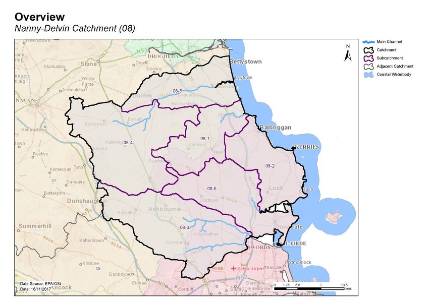
Table of contents
1     Introduction .......................................................................................................................... 1
2     Water body status and risk of not meeting environmental objectives ............................... 2
    2.1     Surface water ecological status ..................................................................................... 2
      2.1.1        Rivers ..................................................................................................................................2
      2.1.2        Transitional and Coastal (TraC) .......................................................................................... 2
    2.2     Groundwater status....................................................................................................... 6
    2.3     Risk of not meeting surface water environmental objectives ...................................... 7
      2.3.1        Rivers ..................................................................................................................................7
      2.3.2        Transitional and Coastal (TraC) .......................................................................................... 7
    2.4     Risk of not meeting groundwater environmental objectives ....................................... 8
    2.5     Protected areas ............................................................................................................. 9
      2.5.1        Drinking water abstractions ............................................................................................... 9
      2.5.2        Bathing waters ...................................................................................................................9
      2.5.3        Shellfish areas ....................................................................................................................9
      2.5.4        Nutrient Sensitive Areas ....................................................................................................9
      2.5.5        Natura 2000 Sites .............................................................................................................11
    2.6     Heavily modified water bodies .................................................................................... 11
3     Significant issues in At Risk water bodies .......................................................................... 11
4     Significant pressures........................................................................................................... 11
    4.1     Water bodies ............................................................................................................... 11
      4.1.1        Rivers, Transitional and Coastal (TraC) ............................................................................12
      4.1.2        Groundwater ....................................................................................................................12
    4.2     Pressure type ............................................................................................................... 13
      4.2.1        Agriculture ........................................................................................................................13
      4.2.2        Hydromorphology ............................................................................................................13
      4.2.3        Urban waste water treatment plants ..............................................................................15
      4.2.4        Diffuse urban ....................................................................................................................15
      4.2.5        Domestic waste water .....................................................................................................15
      4.2.6        Industry ............................................................................................................................18
      4.2.7        Extractive industry ...........................................................................................................18
      4.2.8        Other significant pressures ..............................................................................................18

5     Load reduction assessment ................................................................................................ 18
    5.1     River water body load reductions ............................................................................... 18
    5.2     TraC load reductions.................................................................................................... 18
6     Further Characterisation and Investigative Assessments.................................................. 20
7     Catchment summary .......................................................................................................... 20
8     Areas for Action .................................................................................................................. 21
8.1     Process of Selection ..................................................................................................... 21
    8.2     Overview of process .................................................................................................... 21
9     Environmental Objectives .................................................................................................. 23
    9.1     Surface Water .............................................................................................................. 23
    9.2     Groundwater ............................................................................................................... 23
10 Acknowledgements ............................................................................................................ 26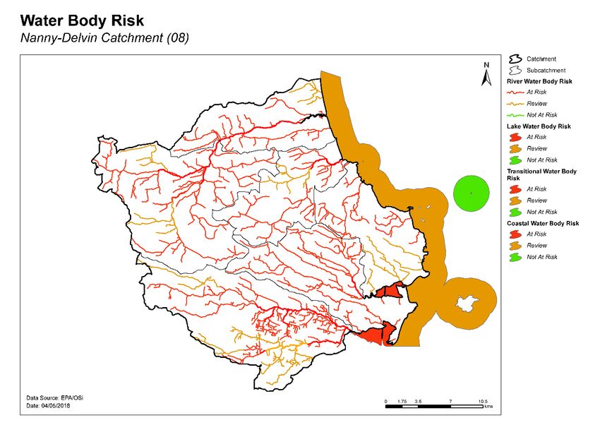
1   Introduction
This catchment includes the area drained by the Rivers Nanny and Delvin and by all streams entering
tidal water between Mornington Point and Sea Mount, Co. Dublin, draining a total area of 711km².
The largest urban centre in the catchment is Swords. The other main urban centres in this catchment
are Donabate, Lusk, Skerries, Balbriggan, Stamullen, Laytown, Bettystown, Duleek, Ashbourne, Ratoath
and Dunshaughlin. The total population of the catchment is approximately 159,230 with a population
density of 224 people per km².

The Nanny River flows east from Kentstown, after which it is joined from the south by the River
Hurley, which drains the area north of Ashbourne. The Nanny continues east through Duleek before
flowing into the Irish Sea at Laytown. The Delvin River flows north east from Garristown and through
Stamullin before entering the sea at Knocknagin Viaduct.

The coastal part of the catchment from Balbriggan to Rush is drained by a series of small rivers
including the Matt, Balcunnin and Palmerstown Rivers. The Ballyboghil River flows east through
Ballyboughal before entering Rogerstown Estuary and flowing into the sea around the Burrow north of
Portraine. The Broadmeadow River flows east from Dunshaughlin, through Rathoath and Ashbourne,
and into Malahide Estuary north of Swords. The Ward River drains the southern edge of the
catchment, flowing east and through Swords, then joining the Broadmeadow River and continuing to
sea via Malahide Estuary.

An arterial drainage scheme was completed on the Broadmeadow and Ward Rivers by the OPW
between 1961 and 1964 and on the Matt River between 1964 and 1965. Flood relief works were
completed on the Nanny River around Duleek in 1998.

The Nanny-Devlin catchment comprises six subcatchments with 34 river water bodies, no lakes, three
transitional and three coastal water bodies, and ten groundwater bodies (Table 1, Figure1).

Table 1. List of subcatchments in the Nanny-Devlin catchment

Subcatchment ID                   Subcatchment Name
08_1                              Delvin_SC_010
08_2                              PALMERSTOWN_SC_010
08_3                              Broadmeadow_SC_010
08_4                              Nanny[Meath]_SC_010
08_5                              Nanny[Meath]_SC_020
08_6                              Ballough[Stream]_SC_010

                                                 1
Figure 1. Subcatchments in the Nanny-Devlin catchment
2 Water body status and risk of not meeting environmental objectives
2.1 Surface water ecological status
2.1.1 Rivers
♦ There were three (9%) river water bodies at Good or High status, and 20 (59%) at less than Good
status in 2015 (Table 2, Figure 2). Eleven (32%) river water bodies are unassigned.
♦ There are no river water bodies and that have a high ecological status objective.
♦ The numbers of water bodies at each status class in 2007-09 and 2010-15 are shown in Figure 4
(rivers).
♦ Five water bodies have improved and two have deteriorated since 2007-09 (Figure 6).
♦ The variation in nutrient concentrations and loads in the Nanny main channel is illustrated in
Appendix 1.
2.1.2 Transitional and Coastal (TraC)
♦ Of the six TraC water bodies, one (17%) was at Good status (North-western Irish Sea (HA 08)), two
were at Moderate status (Malahide Bay and Broadmeadow Water), and one was at Bad status
(Rogerstown Estuary) (50%) in 2015 (Table 2, Figure 2). Two TraC water bodies (33%) are
unassigned (Nanny Estuary and Rockabill).
♦ There is one TraC water body with a high ecological status objective, North-western Irish Sea
HA08. This water body was at Good ecological status in 2015. Figure 3 Appendix 1.
2♦ The numbers of TraC water bodies in each status class in 2007-09 and 2010-15 is shown in Figure
5.
♦ Note the coastal water body (North-western Irish Sea (HA 08), is shared with Catchment 07 and
Catchment 09.
Table 2. Summary of surface water body status and risk categories
Number 2010-15 Status Risk Categories
of water Not at At
bodies High Good Mod Poor Bad Unassigned Review
Risk Risk
Rivers 34 0 3 4 16 0 11 0 9 25
TraC 6 0 1 2 0 1 2 1 2 3
Figure 2 Surface water ecological status
3Figure 3. High ecological status objective water bodies and sites.
River status over the WFD cycles
20
18
16
No. of Water Bodies
14
12
10
Poor
Poor
8
Unassigned
Unassigned
6
Moderate
Moderate
4
Good
2
0
07-09 10-15
WFD Cycles and Status
Figure 4. Number of rivers at each status class in 2007-09 and 2010-15
4Transitional and Coastal water body status
over the WFD cycles
3.5
3
No. of Water Bodies
2.5
2
1.5 Moderate
Unassigned
Unassigned
Moderate
1
Good
High
Bad
0.5
0
07-09 10-15
WFD Cycles and Status
Figure 5. Number of transitional and coastal water bodies at each status class in
2007-09 and 2010-15
Figure 6. Surface water body status changes from 2007-09 to 2010-15
52.2 Groundwater status
♦ There were eight groundwater bodies at Good status (80%) and two (Bettystown and Industrial
Facility (P0014-03) IE_EA_G_062) at Poor (20%) status in 2015 (Table 3, Figure 7 and 8).
Table 3. Summary of water body status and risk for ground waters
Number of 2010-15 Status Risk Categories
water bodies Good Poor Not at Risk Review At Risk
Groundwater 10 8 2 3 5 2
Groundwater status over the WFD monitoring cycles
10
No. of water bodies
9
8
7
6
5
Good
Good
4
3
2
Poor
Poor
1
0
07-12 10-15
Monitoring cycles and status
Figure 7. Number of groundwater bodies at each status class in 2007-12 and 2010-15
Figure 8. Groundwater body status 2010-15
62.3 Risk of not meeting surface water environmental objectives
2.3.1 Rivers
♦ There are no Not At Risk river water bodies in the catchment.
♦ There are nine river water bodies in Review. This applies to five water bodies where more
information is required and three water bodies where measures have recently been implemented
and improvements have not yet been realised.
♦ Twenty-five surface water bodies in the catchment are At Risk of not meeting their water quality
objectives. Measures will be needed in these water bodies to improve the water quality outcomes.
Summary information for the At Risk water bodies is given in Appendix 3.
2.3.2 Transitional and Coastal (TraC)
♦ One TraC water body (Rockabill) is Not at Risk (Figure 9, Table 2) and requires no additional
investigative assessment or measures to be applied, other than those measures that are already in
place.
♦ Two TraC water bodies (North-western Irish Sea (HA 08) coastal and Nanny Estuary, transitional)
are in Review where more information is required.
♦ Three TraC water bodies including two transitional (Rogerstown Estuary and Broadmeadow
Water) and one coastal water body (Malahide Bay) in the catchment are At Risk of not meeting
their water quality objectives. Measures will be needed in these water bodies to improve the
water quality outcomes.
Figure 9. Surface water body risk
72.4 Risk of not meeting groundwater environmental objectives
♦ Three groundwater bodies are Not at Risk (Figure 10, Table 3) and require no additional
investigative assessment or measures to be applied, other than those measures that are already in
place.
♦ Five groundwater bodies are in Review (Duleek, Realtage, Hynestown, Balbriggan and Balrothery)
(Figure 10) because of elevated nitrate concentrations.
♦ Two groundwater bodies are At Risk and measures will be needed in these water bodies to
improve the water quality outcomes. Bettystown is At Risk due to groundwater contribution of
phosphate to At Risk surface waters that are not meeting their water quality objectives (Table 4).
Industrial Facility (P0014-03) IE_EA_G_062 is At Risk because of DCM, MTBE and TBA.
Figure 10. Groundwater body risk
Table 4. Summary of At Risk surface water bodies where phosphate from groundwater may contribute
to an impact.
Groundwater body Receiving water
Receiving water body name
name body code
Bettystown IE_EA_08H010400 HURLEY_030
Bettystown IE_EA_08N010280 NANNY (MEATH)_020
Bettystown IE_EA_08N010400 NANNY (MEATH)_030
Bettystown IE_EA_08N010500 NANNY (MEATH)_040
Bettystown IE_EA_08N010700 NANNY (MEATH)_050
82.5 Protected areas
2.5.1 Drinking water abstractions
♦ There are 12 abstractions in the Nanny Catchment comprising of six public supplies and three
private supplies (Appendix 3).
♦ All 12 of the abstractions are from four groundwater bodies (Lusk-Bog of the Ring IE_EA_G_014,
Swords IE_EA_G_011, Duleek IE_EA_G_012 and Realtage IE_EA_G_020). The list of the public
supplies and the associated water bodies is provided in Appendix 3.
♦ All sources were compliant with the standard for nitrate in 2015.
♦ One source was non-compliant for pesticides in 2015 (East Meath RWS), which is abstracted from
Lusk-Bog of the Ring. The key issue was total pesticides. All other sources were compliant.
2.5.2 Bathing waters
♦ There are eight designated bathing waters in the catchment.
♦ Four of the bathing waters are in satisfactory condition, however four (Rush, South Beach;
Loughshinny Beach; Skerries, South Beach and Balbriggan, Front Strand Beach) failed to meet their
bathing water objectives, due to bacteriological water quality.
♦ The list of the bathing waters and the associated water bodies is provided in Table 5.
2.5.3 Shellfish areas
♦ There are two designated shellfish areas in the catchment (Malahide and Balbriggan/Skerries).
They are compliant with the relevant standards and there no water quality issues of concern.
♦ Details on the shellfish area and its associated water body is summarised in Table 6.
Table 6. Designated shellfish areas in the catchment
Shellfish area Water body intersection Objective met?
Name Code Name Code Yes No
Malahide IEPA2_0057 North-western Irish Sea (HA 08) IE_EA_020_0000
Balbriggan\Skerries IEPA2_0063 North-western Irish Sea (HA 08) IE_EA_020_0000
2.5.4 Nutrient Sensitive Areas
♦ There is one designated Nutrient Sensitive Area (NSA) (Broadmeadow Estuary (Inner)) in the
catchment.
♦ The NSA is associated with Swords waste water treatment which has tertiary treatment and,
therefore, is compliant with environmental objectives for NSAs.
♦ The NSA, associated agglomeration and intersecting water body is provided in Table 7.
Table 7. Nutrient sensitive areas in the catchment
Objective
Nutrient Sensitive Area Agglomeration Water body intersection
met? Comment
Name Code Name Code Name Code Yes No
Broadmeadow Broadmeadow Tertiary treatment
IETW_EA_2001_0026 Swords D0024 IE_EA_060_0100
Estuary (Inner) Water is in place.
9Table 5. Designated bathing waters in the catchment
Bathing Water Water Body Intersection Objective met? Comment Objective met?
Comment
Name Code Name Code Yes No
Rush, South Beach IEEABWC020_0000_0300 North-western Irish Sea (HA 08) IE_EA_020_0000 Rush South beach was classified as having
poor water quality (based on the assessment
of bacteriological results) during 2011-2014
and 2012-2015.
Loughshinny Beach IEEABWC020_0000_0400 North-western Irish Sea (HA 08) IE_EA_020_0000 Loughshinny showed one exceptionally poor
sample after heavy rain in 2014 but would
otherwise meet ‘Sufficient’ quality.
Management plan actions include
decommissioning of existing Septic tank and
diversion of flows to Barnageeragh WWTP
(Skerries). Expected by end 2017.
Skerries, South Beach IEEABWC020_0000_0500 North-western Irish Sea (HA 08) IE_EA_020_0000 Sufficient quality: 2012-2015.
Less than Good quality E.coli, 95th
percentile: 525 and 90th percentile: 305.
Good quality IE, 95th percentile: 144 and
90th percentile: 77.
If comparable performance is achieved in
2016, Good quality is possible.
Balbriggan, Front Strand Beach IEEABWC020_0000_0600 North-western Irish Sea (HA 08) IE_EA_020_0000 Sufficient quality: 2012-2015. Sufficient
quality Ecoli, 95th percentile: 702 and 90th
percentile: 402. Marginal sufficient status IE,
95th percentile: 210, 90th percentile: 114. If
2016 results are similar, it may remain at
‘Sufficient’.
Balbriggan remains extremely vulnerable to
pollution from the Matt River and activities
within Balbriggan harbour area. Control
measures indicated in the 2013 BW profile
to be followed up with Fingal Co. Co.
Laytown/Bettystown IEEABWC020_0000_0700 North-western Irish Sea (HA 08) IE_EA_020_0000
Portrane, the Brook Beach IEEABWC020_0000_0200 North-western Irish Sea (HA 08) IE_EA_020_0000
Donabate, Balcarrick Beach IEEABWC020_0000_0100 North-western Irish Sea (HA 08) IE_EA_020_0000
Rush, North Beach IEEABWC020_0000_0350 North-western Irish Sea (HA 08) IE_EA_020_0000
102.5.5 Natura 2000 Sites
♦ There are two Special Areas of Conservation (SACs) in the catchment (Appendix 4). However,
these SACs do not have water quality and/or quantity conservation objectives for their qualifying
interests.
♦ There are three Special Protected Areas (SPAs) in the catchment:
o Broadmeadow/Swords Estuary SPA
o River Nanny Estuary and Shore SPA
o Rogerstown Estuary SPA
As there are no specific water quality and quantity supporting conditions identified in the site-
specific conservation objectives for these SPAs, the intersecting water bodies are not assigned
priority action for WFD protected area purposes in the second cycle.
2.6 Heavily modified water bodies
♦ There is one designated heavily modified water body (HMWB) in the catchment – Broadmeadow
Water due to public transport infrastructure. It was classified as having Moderate Ecological
Potential in 2013-15.
♦ There are no artificially modified water bodies (AWBs) in the catchment.
3 Significant issues in At Risk water bodies
♦ Excess phosphorus leading to eutrophication is the dominant issue in the rivers.
♦ Alteration of hydromorphological (or physical) conditions are impacted (including the input of
excessive fine sediment) due to land drainage and channelisation. The excessive release of fine
sediment has also occurred through animal access to water bodies. Such impacts have altered the
morphology of water bodies and in turn, altered habitat conditions. The Broadmeadow and
Rogerstown estuaries are also impacted hydromorphologically by the Dublin-Belfast railway line.
♦ The Rogerstown Estuary IE_EA_050_0100 is being impacted by nutrients (DIN) and deteriorated
dissolved oxygen conditions, fish and opportunistic macroalgae are an issue, and the seagrass
beds are in decline. Broadmeadow Water IE_EA_060_0100 is impacted by excess nutrients (DIN),
deteriorated dissolved oxygen conditions and BOD; and fish, phytoplankton and opportunistic
macroalgae are at less than Good status. Malahide Bay IE_EA_060_0000 has macroalgae issues,
however nutrient conditions are satisfactory.
♦ Groundwater bodies act as a pathway to surface waters and may be contributing some of the
phosphate in places. There is also an issue in relation to chemistry, specifically DCM, MTBE and
TBA in IE_EA_G_062.
4 Significant pressures
4.1 Water bodies
♦ Where water bodies have been classed as At Risk, by water quality or survey data, significant
pressures have been identified.
♦ Figure 11 show a breakdown of the number of At Risk water bodies in each significant pressure
category.
114.1.1 Rivers, Transitional and Coastal (TraC)
♦ Significant pressures have been identified by the initial characterisation process in 28 surface
water bodies, 24 of which have multiple pressures. The significant pressures will be refined as
further characterisation is carried out.
♦ The significant pressure affecting the greatest number of water bodies is agriculture, followed by
hydromorphological pressures, urban waste water, diffuse urban, domestic waste water, industry,
mines and quarries and other.
♦ The significant pressures affecting the Rogerstown Estuary IE_EA_050_0100 are agriculture and
domestic waste water. Broadmeadow Water IE_EA_060_0100 is also impacted by domestic waste
water, as well as urban waste water. Malahide Bay IE_EA_060_0000 is impacted by urban waste
water.
4.1.2 Groundwater
♦ There is one At Risk groundwater body, Bettystown IE_EA_G_016, which is impacted by
agriculture; and another groundwater body, Industrial Facility (P0014-03) IE_EA_G_062, which is
impacted by industry.
Significant pressures in At Risk water bodies
25
20
No. of water bodies
15
Groundwater
10 Transitional
Coastal
Rivers
5
0
Figure 11. Significant pressures impacting on At Risk water bodies
124.2 Pressure type
4.2.1 Agriculture
♦ Agriculture is a significant pressure in 21 river water bodies, one transitional water body
(Rogerstown Estuary) (Figure 12, Appendix 3) and one groundwater body (Bettystown
(IE_EA_G_016)). The issues related to farming in this catchment are predominantly due to
enrichment from diffuse phosphorus loss to surface waters from, for example, direct discharges;
or runoff from yards, roadways or other compacted surfaces, or runoff from poorly draining soils.
Sediment can also be a problem from land drainage works, bank erosion from animal access or
stream crossings. Issues with sheep dipping was also noted in one water body. One groundwater
body is impacted by agriculture, and is acting as a pathway to surface water, contributing to
phosphate issues in receiving waters. The pollution impact potential map showing areas of relative
risk for phosphorus loss from agriculture to surface water is given in Appendix 5.
4.2.2 Hydromorphology
♦ Eighteen river water bodies within the Delvin, Palmerstown, Broadmeadow and Nanny [Meath]
subcatchments are subject to extensive modification due to the presence of drainage schemes.
Siltation was also identified as an issue within three of these channelised river water bodies
located within Delvin, Broadmeadow and Nanny [Meath]. An impoundment is impacting a water
body within the Delvin subcatchment. See Appendix 3 for information on these water bodies.
Figure 13.
Table 6a – Hydromorphological pressures on the Nanny/Delvin Catchment
Pressure Sub-Catchment Water body Code
Modification due to Drainage Delvin_SC_010 Delvin_010
Schemes (Channelisation) Palmerstown_ SC_010 Matt_010
Broadmeadow_ SC_010 Broadmeadow_010
Broadmeadow_020
Broadmeadow_030
Broadmeadow_040
Fairyhouse Stream_010
Ratoath Stream_010
Ward_020
Ward_040
Nanny_ SC_010 Hurley_010
Hurley_030
Nanny_010
Nanny_020
Nanny_030
Nanny_ SC_020 Nanny_040
Nanny_050
In River Structures Delvin_ SC_010 Delvin_010
13Figure 12. Water bodies that are At Risk and are impacted by agricultural activities
Figure 13. Water bodies that are At Risk and are impacted by hydromorphological pressures
144.2.3 Urban waste water treatment plants
♦ Urban Waste Water Treatment Plants (WWTPs) and agglomeration networks have been
highlighted as a significant pressure in 15 At Risk water bodies; details are given in Table 8 and
Figure 14. Five At Risk water bodies are impacted by WWTPs and agglomeration networks that are
scheduled to be upgraded before 2021. Four At Risk water bodies are impacted by the Ringsend
Agglomeration, which is due to be upgraded post 2027, one water body, Delvin_040, is impacted
by Stamullen WWTP, which is scheduled to be upgraded in 2025, and one water body,
Broadmeadow Water, is impacted by the Swords WWTP, which will be upgraded in 2017.
Figure 14. Water bodies that are At Risk and are impacted by urban waste water
4.2.4 Diffuse urban
♦ Diffuse urban pressures, caused by misconnections, leaking sewer, pumping station overflows and
runoff from paved and unpaved areas (including a motorway), have been identified as a significant
pressure in eight water bodies (Figure 15, Appendix 3) for several towns which include Balbriggan,
Swords, Dunshaughlin, Ratoath and Ashbourne. The significant issues are a combination of
enrichment due to orthophosphate and ammonia concentrations. There are also impacted
oxygenation conditions.
4.2.5 Domestic waste water
♦ Domestic waste water has been identified as a significant pressure in six river water bodies and
two transitional Rogerstown and Broadmeadow estuaries. The significant issues arise from
unsuitable domestic waste water treatment systems when they are poorly sited on areas of high
pollution impact potential/poorly draining soils, resulting in enrichment and organic
contamination (Figure 16, Appendix 3).
15Table 8. Waste Water Treatment Plants and agglomerations identified as Significant Pressures in At
Risk water bodies and expected completion dates for associated upgrade works, where applicable.
2010-15 Expected
Ecological Completion
Facility name Facility Type Water Body Status Date
Garristown
A0110 < 500 p.e. Delvin_010 Poor NA 1
Stamullen 2,001 to 10,000
D0262 p.e. Delvin_040 Poor 2023
Ringsend
D0034 > 10,000 p.e. Ward_020 2 Poor Post 2027
Ringsend
D0034 > 10,000 p.e. Broadmeadow_010 2 Poor Post 2027
Ringsend
D0034 > 10,000 p.e. Broadmeadow_020 2 Poor Post 2027
Ringsend
D0034 > 10,000 p.e. Ward_040 2 Poor Post 2027
Ardcath
A0017 < 500 p.e. Hurley_030 Moderate NA 1
Kentstown
D0479 500 to 1,000 p.e. Nanny (Meath)_010 Poor 2019
Kentstown
D0479 500 to 1,000 p.e. Nanny (Meath)_020 Poor 2019
Kentstown
D0479 500 to 1,000 p.e. Nanny (Meath)_030 Unassigned 3 2019
Kentstown
D0479 500 to 1,000 p.e. Nanny (Meath)_040 Moderate 2019
Ardcath
A0017 < 500 p.e. Nanny (Meath)_040 Moderate NA 1
Skreen
A0055 < 500 p.e. Nanny (Meath)_040 Moderate NA 1
Portrane,
Donabate, Rush,
Lusk 2,001 to 10,000
D0114 p.e. Turvey_010 2 Unassigned 3 2018
Colecot Cottages
A0107 < 500 p.e. Ballough Stream_020 Poor NA 4
Swords
D0024 > 10,000 p.e. Broadmeadow Water Moderate 2017
Malahide
D0021 > 10,000 p.e. Malahide Bay Moderate NA 1
1 Currently not specified in improvement plans.
2
The agglomeration network, rather than the WWTP, has been identified as a significant pressure impacting
Broadmeadow_010, Broadmeadow_020, Ward_020, Ward_040 and Turvey_010.
3
Ecological Status is not available for Nanny (Meath)_030 and Turvey_010, however, following discussions at the local
authority workshops, both water bodies were deemed to be At Risk of not meeting their environmental objectives.
4
Colecot Cottages agglomeration network is scheduled to be upgraded by 2024, however, the WWTP, which is not scheduled
to be upgraded, has been identified as the significant pressure impacting Ballough Stream_020.
16Figure 15. Water bodies that are At Risk and are impacted by diffuse urban pressures
Figure 16. Water bodies that are At Risk and are impacted by domestic waste water
174.2.6 Industry
♦ One industrial facility has been identified as a significant pressure impacting Nanny (Meath)_030
(Appendix 3). Elevated concentrations of orthophosphate and total ammonia are the significant
issues related to this point source discharge. Groundwater body IE_EA_G_062 has an Industrial
Facility (P0014-03) as a significant pressure, with DCM, MTBE, TBA having an impact.
4.2.7 Extractive industry
♦ Mines & Quarries
A quarry has been identified as a potentially significant pressure in Delvin_020 water body. The
significant issues are a combination of sediment release (clay is being stockpiled beside the water
body) and organic pollution.
4.2.8 Other significant pressures
♦ Waste
There is an unauthorised landfill which has been identified as a potentially significant pressure on
Hurley_030, with an upward trend in ammonia concentrations.
5 Load reduction assessment
5.1 River water body load reductions
♦ Phosphate is the main parameter influencing water quality in rivers in the catchment.
♦ For water bodies where phosphorus monitoring data are available, the reduction in P load that
would be required to bring the mean concentration back to the EQS of 0.035 mg/l as P, can be
estimated using a simple method based on the average 2013 to 2015 concentration and the
average flow, or the estimated 30th percentile flow (Q30) where flow data are not available. The
relative load reductions are ranked on a national scale from Very High (>1 kg/Ha/y), to High (0.5-
1 kg/Ha/y), to Medium (0.25-0.5 kg/Ha/y) to Low (♦ The Rogerstown Estuary is impacted by excess nutrients which are derived from the upstream
catchment area of the Ballough stream and Ballyboghil_010, both of which are also at less than
Good status because of excess nutrients. Estuarine modelling has not been carried out and
therefore the extent of the load reduction that is required cannot be estimated. However, as a
first step, reduction of diffuse losses of N and P should be targeted within the catchment areas of
the Ballough stream and Ballyboghil_010.
♦ The Broadmeadow Estuary is impacted by excess nutrients from the discharge from the Swords
WWTP, and from the upstream catchment areas of the Broadmeadow and Ward Rivers. Estuarine
modelling has not been carried out and therefore the extent of the load reduction that is required
has not been estimated. As a first step, improvements in the estuary from the nutrient reductions
achieved through the planned upgrading of the Swords WWTP should be monitored, followed by
an assessment of any further reductions that may then be required from the catchment area.
♦ The Malahide estuary is impacted by excess nutrients from the Broadmeadow estuary and the
Malahide WWTP. The required load reduction is unknown. Improvements following the upgrade
of the Swords WWTP should be monitored as a first step.
Table 9. Relative load reductions required in monitored water bodies that are At Risk.
Water Body P Load Reduction Required
NANNY (MEATH)_030 High
BALLYBOGHIL_010 Med
BALLOUGH STREAM_020 High
DELVIN_040 Med
BROADMEADOW_010 V. High
HURLEY_030 Low
NANNY (MEATH)_010 Med
RATOATH STREAM_010 Med
DELVIN_010 Low
HURLEY_010 Low
FAIRYHOUSE STREAM_010 Low
NANNY (MEATH)_020 Low
WARD_020 Low
DELVIN_020 Low
WARD_040 Low
196 Further Characterisation and Investigative Assessments
♦ Further characterisation through local catchment assessments is needed in 25 of the At Risk water
bodies to refine the understanding of the significant pressures at the site/field scale so that
specific and targeted measures can be identified.
♦ Further characterisation through local catchment assessments is needed in nine Review water
bodies to refine the understanding of the significant pressures at the site/field scale so that
specific and targeted measures can be identified.
♦ Brief definitions on the 10 IA assessment scenarios are given in Appendix 6 and the number of IAs
required for each scenario are given in Table 10.
Table 10. Local catchment assessment allocation for At Risk and Review river and lake water bodies
Risk IA 1 IA 2 IA 3 IA 4 IA 5 IA 6 IA 7 IA 8 IA 9 IA 10 Total
At Risk 21 8 2 0 7 8 9 0 0 0 55
Review 8 3 2 0 0 3 1 0 0 0 17
Note water bodies may have multiple categories of Local Catchment Assessments
7 Catchment summary
♦ Of the 34 river water bodies, 25 are At Risk of not meeting their WFD objectives.
♦ Excess nutrient loss, mainly phosphate, leading to eutrophication is a major issue for rivers in the
catchment. The significant pressures relating to excess nutrients are primarily agricultural (diffuse
and point), but also waste water (urban and domestic) and diffuse urban.
♦ Hydromorphological (or physical) conditions (including the input of excessive fine sediment) and
poor habitat quality are also an issue for 18 river water bodies.
♦ There are three TraC water bodies At Risk, Rogerstown Estuary IE_EA_050_0100 and
Broadmeadow Water IE_EA_060_0100 are At Risk and are impacted by excess nutrients, with the
significant pressures being agriculture and domestic waste water for Rogerstown Estuary, and
domestic and urban waste water for Broadmeadow Water. Malahide Bay IE_EA_060_0000 is
impacted by urban waste water, resulting in macroalgae issues.
♦ There are two At Risk groundwater bodies in the catchment - Bettystown IE_EA_G_016 and
Industrial Facility (P0014-03) IE_EA_G_062. Bettystown IE_EA_G_016 is impacted by agriculture,
and is acting as a pathway to surface water, contributing to phosphate issues in places. Industrial
Facility (P0014-03) IE_EA_G_062 is impacted by an industrial facility, which is impacted by DCM,
MTBE and TBA.
208 Areas for Action
The characterisation outcomes described above have highlighted that there is significant work to do in
the catchment to protect and restore water quality, and meet the objectives of the WFD. During the
development of the draft river basin management plan it became apparent that there would be a
need to prioritise areas for collective action so that the best return on investment could be achieved.
190 Areas for action have been selected nationally in a process as described below. There are 3 areas
for action in the Nanny/Delvin catchment.
8.1 Process of Selection
Following the publication of the draft river basin management plan in early 2017, the EPA and the
Local Authority Waters and Communities Office (LAWCO) jointly led a collaborative regional workshop
process to determine where, from a technical and scientific perspective, actions should be prioritised
in the second cycle. The prioritisation process was based on the priorities in the draft river basin
management plan, the evidence from the characterisation process, and the expertise, data and
knowledge of public body staff with responsibilities for water and the different pressure types. The
recommended areas for action selected during the workshops were then agreed by the Water and
Environmental Regional Committees. Since this selection, the Local Authorities Water and
Communities Office (LAWCO) have undertaken public engagement and feedback sessions in each local
authority.
The recommended areas for action are an initial list of areas where action will be carried out in the
second cycle. All water bodies that are At Risk still however, need to be addressed. As issues are
resolved, or when feedback from the public engagement process is assessed, areas for action may be
removed from the list and new areas will be added. If additional monitoring shows that new issues
have arisen, new areas may become a priority and may need to be added to the work programme.
The initial list of areas for action is not therefore considered as a closed or finite list; it simply
represents the initial areas where work will be carried out during the second WFD planning cycle from
2018 to 2021.
8.2 Overview of process
The outcomes for the Nanny catchment are summarised below.
♦ Three recommended areas for actions (Table 11, Figure 17) were selected.
♦ These are the Rogerstown Estuary, Lower Nanny Tillage and Ashbourne Diffuse Urban.
♦ These include eight river water bodies – seven At Risk and one Review.
♦ One groundwater body, which is At Risk due to groundwater contribution of nutrients to
surface water bodies, intersects with one of the recommended areas for action, see Table 12.
Actions taken to improve surface water will need to take account of the groundwater
contribution to surface water.
A remaining 31 At Risk and Review surface water bodies were not included in the recommended areas
for action for the second cycle. The distribution of these is presented in Figure 18. These include:
♦ 26 river water bodies – 18 At Risk and eight Review, and
♦ Five transitional and coastal water bodies – three At Risk and two Review.
Table 11. Recommended Areas for Action in the Nanny catchment
21Number
Recommended Local
of water SCs Reason for Selection
area for action authority
bodies
• Building on improvements by IW, including sewer
improvement in Turvey, installation of reed beds and
discussion with Tesco on their facility.
• Building on monitoring completed by Fingal County
Rogerstown 08_6
5 Fingal Council.
Estuary 08_2
• Discharges into two designated bathing waters (Portrane
and Donabate).
• Headwaters to Rogerstown Estuary.
• Subcatchment project.
• Pilot project to examine impact of tillage on poorly
draining soils.
• The Nanny Meath river discharges into coastal waters
Lower Nanny
2 08_5 Meath which have both designated bathing and shellfish areas.
Tillage
• Building on existing improvements by Irish Water at
Duleek waste water treatment plant.
• One deteriorated water body.
• Pilot project to address urban diffuse pressures with focus
on 500m stretch of Broadmeadow_020.
Ashbourne Building on work carried out by Meath and Irish Water to
1 08_3 Meath
Diffuse Urban rehabilitate leaky sewers.
• Small and manageable area with single pressure (urban
diffuse).
Table 12. Groundwater body intersecting with surface water bodies in one Recommended Area for
Action
Groundwater body Intersecting surface water bodies Recommended Area for
Code Name Risk Code Name Action
IE_EA_08N010500 NANNY (MEATH)_040
IE_EA_G_016 Bettystown At risk Lower Nanny Tillage Project
IE_EA_08N010700 NANNY (MEATH)_050
229 Environmental Objectives
9.1 Surface Water
♦ Assuming resources are available and actions are taken in the recommended areas for action, of
the seven At Risk surface water bodies, it is predicted that all will achieve their objective by 2027.
For the one Review surface water body, the absence of information on this water body means that
there is no scientific basis to quantify an environmental objective date and therefore a 2027 date
is set, see Table 13.
Table 13. Environmental objective dates for water bodies in the Recommended Areas for Action
Risk Category No. of Water No. of WBs for 2021 No. of WBs for 2027
Bodies Improvement Status Improvement
Rivers
At Risk 7 0 7
Review 1 0 1
Total 8 0 8
♦ One surface water body has met its 2015 environmental objective.
♦ As action is not yet planned to be taken in the remaining 21 At Risk surface water bodies, a 2027
date is applied to all 21 of the water bodies.
♦ For the 10 Review surface water bodies, the absence of information on these water bodies means
that there is no scientific basis to quantify an environmental objective date and therefore a 2027
date is applied, see Table 14.
Table 14. Environmental objectives dates in the At Risk and Review surface water bodies not included
in Recommended Areas for Action
Risk Category No. of Water No. of WBs for 2021 No. of WBs for
Bodies Improvement 2027 Status
Improvement
Rivers
At Risk 18 0 18
Review 8 0 8
TraC’s
At Risk 3 0 3
Review 2 0 2
Total 31 0 31
9.2 Groundwater
♦ Eight of the ten groundwater bodies are currently Good status and, therefore, have met their
environmental objectives.
♦ Of the two groundwater bodies in the Nanny catchment that are less than Good status, both have
a 2027 environmental objective.
23Figure 17. Location of Recommended Areas for Action in the Nanny-Devlin Catchment
24Figure 18. Location of At Risk and Review water bodies located outside Recommended Areas for Action in the Nanny-Devlin Catchment
2510 Acknowledgements
This Nanny -Devlin Catchment Assessment (Version 3) has been produced by the Catchment Science &
Management Unit, EPA, with the assistance of the following:
• Fingal County Council
• Meath County Council.
• Inland Fisheries Ireland.
• Local Authorities Waters & Communities Office.
• Irish Water.
• RPS Group.
• Ecological Monitoring & Assessment Unit, EPA.
• Hydrometric & Groundwater Section, EPA.
• Informatics Section, EPA.
• Laboratories, EPA.
• Office of Environmental Enforcement, EPA.
• Department of Housing, Planning and Local Government.
• DAFM Forest Service.
• DAFM Agriculture.
• Bord Na Mona.
• Coillte.
• Teagasc.
• Geological Survey Ireland.
• National Federation of Group Water Schemes.
• National Parks and Wildlife Service.
• National Water Forum.
26Appendix 1 High ecological status objective water bodies and sites
Water body/Site Type Codes 2015 Status
North-western Irish Sea (HA 08) TraC IE_EA_020_0000 Good
27Appendix 2 Catchment scale nutrient concentrations and in-stream loads
The results of the instream water quality assessment for the Nanny and Delvin main channel
catchments are illustrated in Chart 1 and Chart 2, respectively. The assessment is based on the mean
concentrations between 2013 and 2015 at each site from the headwaters down to the estuary. The
results show that nutrients are elevated in both main channels.
Chart 1 shows the highest concentration of orthophosphate is observed in the head waters Nanny
(Meath)_010 at 0.11mg/l, which is the receiving water for the Kentstown Waste water Treatment
Plant (WWTP) and decreases gradually to 0.042mg/l at the catchment outlet (Nanny (Meath)_050.
Similarly, to the orthophosphate concentrations, ammonia concentrations spike in the head waters at
0.237mg/l and decrease rapidly downstream but remain only marginally below the Environmental
Quality Standard (EQS) for good status (0.065mg/l), with the exception of the Nanny (Meath)_040
which exceeds the EQS at 0.067mg/l.
The TON concentrations remain elevated above the 2.6mg/l drinking water threshold along the main
channel with a spike towards the catchment outlet Nanny (Meath)_050 at 3.87mg/l, which is the
receiving water for the Bellewstown WWTP.
Chart 1: Nanny Main Channel Nutrients
0.250 5.0
Ortho-P & Total Ammonia (mg/l)
0.225 4.5
Total Oxidised Nitrogen (mg/l)
0.200 4.0
0.175 3.5
0.150 3.0
0.125 2.5
0.100 2.0
0.075 1.5
0.050 1.0
0.025 0.5
0.000 0.0
NANNY NANNY NANNY
(MEATH)_010 (MEATH)_030 (MEATH)_050
Ortho-Phosphate Total Ammonia Total Oxidised Nitrogen
Chart 2 shows that nutrient concentrations increase downstream along the Delvin main channel. The
Delvin_010 to Delin_040 water bodies are the receiving waters for a small number of WWTPs
including the Clonalvy, Garristown, Naul and the Stamullen.
The average 2013-2015 orthophosphate concentrations are elevated and range from 0.063mg/l in the
headwaters to 0.11mg/l to the catchment outlet.
Ammonia concentrations increase from 0.051 to 0.125mg/l towards the catchment outlet and are
elevated above the Environmental Quality Standard (EQS) for good status (0.065mg/l) in Delvin_020
and Delvin_040.
28The TON concentrations remain elevated along the main channel with the highest concentrations of
3.9 to 4.0mg/l in the Delvin_030 and Delvin_040, respectively.
Chart 2: Delvin Main Channel Nutrients
0.14 4.5
4.0
Ortho-P & Total Ammonia (mg/l)
0.12
Total Oxidised Nitrogen (mg/l)
3.5
0.10
3.0
0.08 2.5
0.06 2.0
1.5
0.04
1.0
0.02
0.5
0.00 0.0
DELVIN_010 DELVIN_020 DELVIN_030 DELVIN_040
Orthophosphate Total Ammonia Total Oxidised Nitrogen
29Appendix 3 Summary information on At Risk and Review surface water bodies
High
Ecological
Status
Ecological Ecological Objective Date to Meet
Subcatchment Water Status Status Water Environmental Recommended Area
code Water body code Water body name body type Risk 07-09 10-15 Body Y/N Significant Pressures Objective for Action Name
08_1 IE_EA_08D010300 Delvin_030 River Review Unassigned Unassigned N 2027
08_1 IE_EA_08D010080 Delvin_010 River At risk Poor Poor N Ag,DWW,Hymo,UWW 2027
08_1 IE_EA_08D010250 Delvin_020 River At risk Moderate Moderate N Ag,Hymo,M+Q 2027
08_1 IE_EA_08D010400 Delvin_040 River At risk Poor Poor N Ag,UWW 2027
08_1 IE_EA_020_0000 North-western Irish Sea (Ha 08) Coastal Review High Good Y 2027
08_2 IE_EA_08B310940 Balcunnin_010 River Review Unassigned Unassigned N 2027
08_2 IE_EA_08M010900 Matt_010 River At risk Unassigned Unassigned N DU,Hymo 2027
08_2 IE_EA_08M030500 Mill Stream (Skerries)_010 River At risk Unassigned Unassigned N DU 2027
08_2 IE_EA_08P030930 Palmerstown 08_010 River Review Unassigned Unassigned N 2027 Rogerstown Estuary
08_2 IE_EA_050_0100 Rogerstown Estuary Transitional At risk Moderate Bad N Ag,DWW 2027
08_3 IE_EA_08W010050 Ward_010 River Review Poor Unassigned N 2027
08_3 IE_EA_08B020400 Broadmeadow_010 River At risk Poor Poor N Ag,DU,Hymo,UWW 2027
08_3 IE_EA_08B020600 Broadmeadow_020 River At risk Poor Poor N DU,Hymo,UWW 2027 Ashbourne Diffuse Urban
08_3 IE_EA_08B020700 Broadmeadow_030 River At risk Unassigned Poor N Ag,DWW,Hymo 2027
08_3 IE_EA_08B020800 Broadmeadow_040 River At risk Poor Poor N Ag,Hymo 2027
08_3 IE_EA_08D030300 Dunshaughlin Stream_010 River Review Poor Good N 2027
08_3 IE_EA_08F010500 Fairyhouse Stream_010 River At risk Poor Poor N Ag,DWW,Hymo 2027
08_3 IE_EA_08R010150 Ratoath Stream_010 River At risk Poor Poor N Ag,DU,DWW,Hymo 2027
08_3 IE_EA_08W010070 Ward_020 River At risk Poor Poor N Ag,Hymo,UWW 2027
08_3 IE_EA_08W010300 Ward_030 River Review Poor Good N 2027
08_3 IE_EA_08W010610 Ward_040 River At risk Poor Poor N DU,Hymo,UWW 2027
08_3 IE_EA_060_0100 Broadmeadow Water Transitional At risk Moderate Moderate N DWW,UWW 2027
08_4 IE_EA_08F050930 Flemingstown 08_010 River Review Unassigned Unassigned N 2027
08_4 IE_EA_08N010400 Nanny (Meath)_030 River At risk Unassigned Unassigned N Ag,Hymo,Ind,UWW 2027
08_4 IE_EA_08H010200 Hurley_010 River At risk Poor Moderate N Ag,Hymo 2027
08_4 IE_EA_08H010280 Hurley_020 River Review Poor Good N 2027
08_4 IE_EA_08H010400 Hurley_030 River At risk Moderate Moderate N Ag,Hymo,Other,UWW 2027
08_4 IE_EA_08N010110 Nanny (Meath)_010 River At risk Poor Poor N Ag,DWW,Hymo,UWW 2027
08_4 IE_EA_08N010280 Nanny (Meath)_020 River At risk Moderate Poor N Ag,Hymo,UWW 2027
08_5 IE_EA_08B330980 Betaghstown 08_010 River Review Unassigned Unassigned N 2027
3008_5 IE_EA_08M020100 Mosney_010 River At risk Poor Poor N Ag,DU,DWW 2027
08_5 IE_EA_08N010500 Nanny (Meath)_040 River At risk Poor Moderate N Ag,Hymo,UWW 2027 Lower Nanny Tillage
08_5 IE_EA_08N010700 Nanny (Meath)_050 River At risk Moderate Poor N Ag,Hymo 2027 Lower Nanny Tillage
08_5 IE_EA_030_0100 Nanny Estuary Transitional Review Unassigned Unassigned N 2027
08_6 IE_EA_08B031500 Ballough Stream_010 River At risk Unassigned Unassigned N Ag 2027 Rogerstown Estuary
08_6 IE_EA_08T020700 Turvey 08_010 River At risk Unassigned Unassigned N Ag,DU,UWW 2027 Rogerstown Estuary
08_6 IE_EA_08B012200 Ballyboghil_010 River At risk Poor Poor N Ag 2027 Rogerstown Estuary
08_6 IE_EA_08B031600 Ballough Stream_020 River At risk Poor Poor N Ag,UWW 2027 Rogerstown Estuary
08_6 IE_EA_060_0000 Malahide Bay Coastal At risk Moderate Moderate N UWW 2027
Ag: Agriculture M+Q: Mines and Quarries
DWW: Domestic Waste Water Peat: Peat Drainage and Extraction
For: Forestry DU: Diffuse Urban
Hymo: Hydromorphology UWW: Urban Waste Water
Ind: Industry
Note: Significant Pressures for Review water bodies have not been included as they will need to be confirmed as part of an Investigative Assessment.
Protected Area: IfIf awater
waterbody
bodyisisone
oneorormore
more of
of the
the following,
following: Drinking
Drinking Water Protected Area;
Area,
Bathing Water,
Water; Shellfish
Shellfish Water,
Area; Nutrient
Nutrient Sensitive
Sensitive Area
Area or;
or aa Natura
Natura 2000
2000 site
sitewith
withqualifying
a water
dependent
interest, qualifying
then interest
it has been with a as
highlighted water quality and/or
a protected area inquantity conservation objective, then it
this table.
has been highlighted as a protected area in this table.
31Appendix 4 Drinking water supplies in the catchment
Scheme Code Scheme Name Water Body Water Body Code Objective Reason
met? Yes why
/No not met
2300PRI2153 Largo Foods Lusk-Bog of the Ring IE_EA_G_014 Yes N/A
0900PRI9021 Cooneys, Annasbrook Lusk-Bog of the Ring IE_EA_G_014 Yes N/A
2300PRI4011 Churchfields Housing Swords IE_EA_G_011 Yes N/A
Estate
2300PUB1008 East Meath RWS Lusk-Bog of the Ring IE_EA_G_014 No Total
pesticid
es
2300PUB1051 Bellowstown Borehole Duleek IE_EA_G_012 Yes N/A
2300PUB1052 Hollymount Borehole Duleek IE_EA_G_012 Yes N/A
2300PUB1104 Dean Hill Borehole Realtage IE_EA_G_020 Yes N/A
2300PUB1105 Danestown Borehole Realtage IE_EA_G_020 Yes N/A
0900PUB1003 F_ZONE3 Lusk-Bog of the Ring IE_EA_G_014 Yes N/A
Bog of the Ring
Borehole PW2
F_ZONE3 Lusk-Bog of the Ring IE_EA_G_014 Yes N/A
Bog of the Ring
Borehole PW3
F_ZONE3 Lusk-Bog of the Ring IE_EA_G_014 Yes N/A
Bog of the Ring
Borehole PW4
F_ZONE3 Lusk-Bog of the Ring IE_EA_G_014 Yes N/A
Bog of the Ring
Borehole PW5
32Appendix 5 Prioritisation of water bodies with Natura 2000 site qualifying
interests
Relevant Qualifying Target Water body Water Status Prioriti Co Survey
SAC Name
interests status type bodies (risk) se? de data?
Malahide Estuary SAC
000205 none
Rogerstown Estuary
SAC 000208 none
33Appendix 6 Pollution Impact Potential (PIP) Map for Phosphate
For areas where agriculture is deemed as the significant pressure, areas of high risk to surface water
can be targeted. The map below shows relative risk of loss of phosphate to surface water. The risk of
phosphate losses is strongly correlated on whether the land is poorly draining or free draining and the
loadings applied i.e. significant loadings applied on poorly draining areas result in a high potential risk to
surface water. However, this figure does not imply that actual losses from these areas are occurring but is
a useful tool for informing where resources should be focused (i.e. by allowing high risk areas to be
identified and prioritised for further investigation). PIP maps are available online at a scale of 1:20,000 and
can be accessed by public bodies via the EDEN process.
34Appendix 7 Local catchment assessment categories
Category Assessment & Measures Evaluation Details
IA1 Further information provision (e.g. from IFI, LAs,
EPA)
IA2 Point source desk-based assessment
IA3 Assessment of unassigned status water bodies,
requiring field visit(s)
IA4 Regulated point sources, requiring field visit/s
IA5 Stream (catchment) walk to evaluate multiple
sources in a defined (1 km) river stretch (used as
the basis for estimating resource requirements)
IA6 Stream (catchment) walk in urban areas
IA7 Stream (catchment) walk along >1 km river
stretches
IA8 Stream (catchment) walk along high ecological
status (HES) objective rivers
IA9 Lakes assessment, requiring field visits
IA10 Groundwater assessments, requiring field visits
35You can also read