Geology and History of the Cumberland Plateau - National ...
←
→
Page content transcription
If your browser does not render page correctly, please read the page content below
National Park Service
U.S. Department of the Interior

Big South Fork National River and Recreation Area
Oneida, Tennessee

  Geology and History of
  the Cumberland Plateau
Geological History
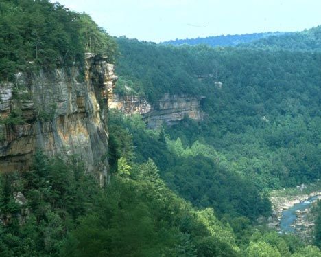
Rising over 1000 feet above the region around it, the Cumberland Plateau is a large, flat-topped
tableland. Deceptively rugged, the Plateau has often acted as a barrier to man and nature’s
attempts to overcome it. The Plateau is characterized by rugged terrain, a moderate climate, and
abundant rainfall. Although the soils are typically thin and infertile, the area was once covered
by a dense hardwood forest equal to that of the Appalachians less than sixty miles to the east. As
a landform, this great plateau reaches from north-central Alabama through Tennessee and
Kentucky and Pennsylvania to the western New York border. Geographers call this landform
the Appalachian Plateau, although it is known by various names as it passes through the differ
ent regions. In Tennessee and Kentucky, it is called the Cumberland Plateau.
Within this region, the Cumberland River and its tributaries are formed. A view from any over-
look quickly confirms that the area is indeed a plateau. The adjoining ridges are all the same
height, presenting a flat horizon.
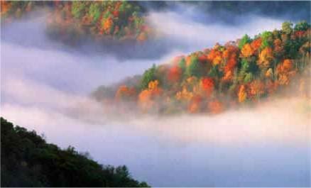
The River Systems
The Clear Fork River and the New River
come together to form the Big South Fork of
the Cumberland River, the third largest
tributary to the Cumberland. The Big South
Fork watershed drains an area of 1382 square Leatherwood Ford in the evening sun
miles primarily in Scott, Fentress, and Morgan
counties in Tennessee and Wayne and Overlooks
McCreary counties in Kentucky.
Kentucky, Blue Heron Area
Yahoo Falls Devils Jump #
The rivers and streams have been the major
Blue Heron Catawba Bear Creek
force that has created the often-dramatic
landscape of the area today. As the streams
Tennessee, Bandy Creek Area
have cut downward into the sandstone, which
East Rim # Leatherwood
caps the plateau, they have carved out gorges
Sunset * Angel Falls *
and canyons, leaving behind cliffs, natural
arches, rock shelters and waterfalls. Eleva
Tennessee, Rugby Area
tions are not extreme, but change suddenly.
Honeycreek #
They range from 1800 feet along the highest
ridge tops to 800 feet along the river. # Easy Access - - Wheelchair accessible
* Undeveloped - - No protective railing
1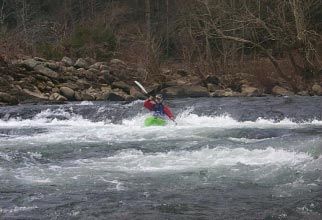
Geological History
Rocks of the Plateau
The rocks that now form the cap of the Cumberland Plateau were laid down in a ancient shal
low sea over 350 million years ago, during the Mississippian (360- 320 million years ago) and the
Pennsylvanian (320 - 296 million years ago) periods of geologic time. These sediments were
deposited in horizontal layers thousands of feet thick. The resulting pressure hardened these
sediments into layers of limestone, shale, coal, and sandstone. Beginning about 285 million years
ago, the entire area was slowly lifted over 2000 feet above sea level and erosion immediately
began to shape the landscape.
It is interesting to note that most of the coal A good place to view up close layers of
mined in Kentucky and all in Tennessee comes shale, coal, sandstone and the overhang
from the Cumberland Plateau. At present, the ing conglomerate cap is near Leather-
river has just begun to cut into the limestone wood Ford Trailhead on the Angel Falls
deposits, which are estimated to be over 320 Trail. The trail is 2.0 miles one way.
million years old. Limestone, therefore, plays
an insignificant part in the landscape of the
area. As you travel from the gorge rim to the
river below, the various rock layers become
evident.
Learn more about coal mining on the Cum
berland Plateau. Visit the town of Stearns,
Kentucky and ride the Scenic Railway down
to the Blue Heron Mining Community. You
The school house, one of many "ghost structures"
can also drive to Blue Heron via KY Hwy 742.
which are part of the Blue Heron Mining Community
A self-guided brochure “A Guide to the Blue
Heron Community” is available to enhance
your visit.
2Geology
Dramatic cliffs, arches, rock shelters, chimneys, and other interesting features are carved into
the sandstone of the plateau. The conglomerate rock that caps the sandstone is quite resistant to
erosion while the underlying rocks are much softer and more easily eroded. Differential weath
ering is responsible for the formation of many fascinating features of the Big South Fork. Hun
dreds of arches and rock shelters of varying size wait to be discovered by the adventurous
explorer; however, hiking or horse trails lead to many of them, which have been named.
WATERFALLS
Cumberland Falls KY 90 near Corbin, KY
Yahoo Falls KY 700 near Whitley City
Slave Falls Fork Ridge Road Sawmill Trailhead
Northrup Falls One mile east of Allardt, Colditz
Cove State Natural Area then one
mile south of TN 52
ROCKSHELTERS
Yahoo Falls Yahoo Falls Scenic Area off KY 700
Dome Rockhouse Big Island Loop (Horse Trail) Yahoo Falls, Kentucky's highest
waterfall drops 113 feet.
Indian Rockhouse Slave Falls Loop Trail
Hazard Cave Pickett State Park
Witches Cave Gentleman’s Swimming Hole Trail
The best hiking trails for viewing numerous large
rockshelters are the Middle Creek Trail and the lower
loop of the Twin Arches Trail.
CHIMNEYS
Two large chimney rocks can be viewed from Station
Camp Road as you near the river access. Chimney Rock
3Geology
Arches
The Big South Fork National River and Recreation Area abounds in dramatic cliffs, arches, and
rockshelters. The region may contain more natural arches that any other region in the eastern
United States. Natural arches are found frequently in the Big South Fork at the edges of the
tableland surface, there the resistant Rockcastle Conglomerate slowly succumbs to erosion.
Arches form along gorge edges where the resistant sandstone is able to support its own weight
when layers below erode away.
TWIN ARCHES were formed by headward
erosion along a narrow ridge . The arches are
considered to be the largest arches in the Big
South Fork and quite possibly in the Eastern
United States. They may be reached by a
number of routes, the shortest being a .7 mile
hike from the Twin Arches Trailhead.
NEEDLE ARCH is a thin, delicate arch that
was left standing alone when the back of the
rockshelter of which it was once a part
eroded. It can be reached from the Sawmill North Arch of the Twin Arches
Trailhead on Fork Ridge Road.
SPLIT BOW ARCH is unusual in that a KOGER ARCH is a broad arch and was the
narrow finger of the bluff split away from the result of rockshelter erosion. It is accessible
main bluff. When large chunks of rock fell, a from the Sheltowee Trace and also a short
high, thin bridge was all that was left. You trail leading up from Devils Creek Road near
can see the arch from an overlook or hike a the Yamacraw area.
0.7 loop trail that will take you through the
arch. Signs at the Bear Creek Scenic Area in BUFFALO ARCH is also accessible from the
Kentucky (just off KY 742) will direct you to Sheltowee Trace near the Big South Fork/
the arch. Daniel Boone National Forest boundary on
Rock Creek. Located in the Daniel Boone
YAHOO ARCH is another arch formed as a National Forest, it can also be reached from
result of erosion at the back of a rockshelter. Hwy 1363.
It can be easily reached from the Yahoo Falls
Scenic Area just off KY 700. GOBBLERS ARCH in the Daniel Boone
National Forest provides a passageway for an
alternative to the Sheltowee Trace leading
from Rock Creek to Peters Mountain
Trailhead. 4Human History
The First Humans mains in rock shelters, in riverside campsites
and in remote upland sites. These people
About 20,000 years ago the great ice sheets moved their camps frequently, following the
began retreating northward, opening the way seasonal changes in food supply. It is likely
for nomadic hunters to enter North America. that their bands were small in number, con
By 10,000 BC these early Americans had sisting primarily of members of the same
reached the southeast searching for large family.
game animals such as elk, bison, deer and
bear. The numerous rockshelters found in the About 900 to 1000 AD a major shift to agricul
Big South Fork made convenient homes for ture led the Indians to leave the Plateau for
the early peoples. the more fertile river bottoms of larger
streams such as the Tennessee and Cumber-
As millennia passed the climate and forest land. There they lived in towns and villages
changed and the large herd animals began to developing complex societies highly depen
disappear. The people began to adapt to a dent on agriculture. Only occasionally did
changing environment. Instead of hunting hunting parties venture into the remote areas
large animals they now depended on a variety of the Cumberland Plateau. By the time the
of smaller game and plant foods. Eventually first longhunters began to explore the area in
they began to collect plants and hunt on a the late 1700s there was only very sparse
seasonal basis to insure a more sustained food Indian settlement in the region.
supply. Evidence of these activities still re-
Archaeology
Many of the dry rockshelters on the Cumber-
land Plateau have preserved clues about
prehistoric life not found in other open sites.
Unfortunately about 98% of these sites have
been damaged through vandalism and the
hunting of relics. Artifacts and archaeological
sites are rare, non-renewable resources. You
can help preserve Big South Fork’s cultural
history. If you find an artifact or archaeologi
cal site, leave it as you find it. Please report
any recent site destruction you may observe
or any artifacts or sites you may discover.
Trained archeologists under park service
supervision work to recover artifacts .
5Human History
European Settlement around the region. The terror caused by
guerilla warfare during the Civil War did little
but isolate the region even more. Industry was
By 1780 the Big South Fork and its tributaries
limited to simple water-powered gristmills,
were being actively hunted and explored. By
moonshining and the mining of “nitre”
1800 there were several permanent home-
(potassium nitrate) for gunpowder. You can
steads in the area. The land itself was quite
see evidence of nitre mining in one of the
rugged as local names still suggest. Names
rockshelters on the Twin Arches Loop Trail.
such as Troublesome, Difficulty, and No
Business leave little doubt. Early settlement
was confined to the river and streams where
small sections of fertile land could be found.
The first settlers came from Virginia and
North Carolina and were primarily of English
and Scotch-Irish ancestry. Local place names
still give testimony to these early families.
These hardy pioneers thrived on the indepen
dence and isolation of the Cumberland
Plateau. Through hard work and determina
tion they established small, self-sufficient
farms and eventually small communities. For
the next 100 years relatively little changed on History is interpreted at pioneer camp set up for visitors
the Plateau as progress seemed to flow and school children to enjoy.
Cemeteries
Many of the older gravesites in the area are
simply marked with an upturned stone and
are scarcely recognizable. A visit to the one of
the larger cemeteries such as the Katie
Blevins, Hattie Blevins, or Terry cemeteries
will give testimony to some of the earliest
family names. Jonathan Blevins, the first
longhunter to permanently settle here, is
buried near Station Camp Creek.
The Oscar Blevins Farm is one example of a subsistence
farm. Others are the Lora Blevins Farm and the John
Litton/General Slaven Farm. 6Human History
Industrial Revolution
The solitude and isolation were not to last
forever, as the Industrial Revolution finally
came to the Cumberland Plateau. The region’s
rich timber and coal resources were basically
untapped in the early 1900s, and the nation’s
industrialists saw it as a source of wealth. The
Big South Fork was suddenly alive with logging,
railroads, and coal mining. Logging and mining
camps seemed to spring up overnight as the
local people were drawn by the lure of wages.
Companies such as the Stearns Coal and
Lumber and Tennessee Stave and Lumber were The O&W Bridge can be reached by driving or hiking.
to have a profound influence on the area.
The pace was rapid until the end of World War II when the area’s coal and timber resources
were depleted. By the early 1950s logging camps, railroads and mines began to be abandoned
and once thriving towns such as Zenith, Barthell and Blue Heron became ghost towns. Suddenly
many people found themselves unemployed. No longer were they content to return to the
homesteads and live in the remote isolated “hollers.” The lifestyle of most was changed forever.
The old communities were slowly abandoned as people searched for a better way of life. Many
left the area entirely as they looked for work in the cities of the Industrial North. The land itself
was also changed forever as the scars left behind by logging, mining, and farming were left for
nature to slowly heal.
Blue Heron Mining Community
Hike, drive, or ride the Scenic Railway to the
Blue Heron Mining Community. Pick up a
copy of “A Guide to the Blue Heron Commu
nity” to assist you as you walk around the re-
created mining town of Blue Heron.
Coal mining exhibit
7 Blue Heron TippleNational Park Service
Big South Fork National River and Recreation Area
There are many reminders still evident of the and Recreation Area in 1974 the area is being
past activity that has influenced the Big South preserved and opened for recreational use.
Fork. There are trail guides available in the Now others can enjoy the rugged beauty that
bookstores that will help you to identify more local residents have long known and appreci
of the historical sites. Today the area is under- ated.
going change as a new chapter in the history
of the Big South Fork begins. With the estab
lishment of the Big South Fork National River
Recreational Activities
ATV Riding Backpacking Campfire Programs
Canoeing Exploring Fishing
Four-Wheel Driving Hiking Horseback Riding
Hunting Kayaking Mountain Bike Riding
Nature Walks Photography Picnicking
RV Camping Road Bike Riding Rock Climbing
Scenic Views/Overlooks Scuba Snorkeling
Swimming Tent Camping Trail Bike Riding
Trapping Whitewater Rafting
8National Park Service
Obed Wild and Scenic River
Wild and scenic are good words to describe the Big South Fork, it is a free-flowing river
the Obed river system. Located south of the and changes dramatically with the weather
Big South Fork, the Obed Wild and Scenic conditions and the seasons. The visitor
River was added to the National Park system center in Wartburg is the best place to plan
in October, 1974. Consisting of four streams, your visit to the park. Wartburg, TN is
Daddys Creek, Clear Creek, the Emory River located 34 miles south of Oneida on US 27.
and the Obed River, it shares like geological
features and a similar history with the Big
South Fork. In his Thousand Mile Walk to the
Gulf, John Muir said of the Emory River, “Its
banks are luxuriantly peopled with rare and
lovely flowers and overarching trees, making
one of Nature’s coolest and most hospitable
places. Every tree, every flower, every ripple
and eddy of this lovely stream seemed sol
emnly to feel the presence of the great Cre
ator.”
The Obed offers some of the best whitewater
Hiker at Lilly Bluff Overlook
paddling on the Cumberland Plateau. Like
Kayaking has long been popular on
the rivers and streams of Obed
WSR
9Park Neighbors
Daniel Boone National Forest
The Daniel Boone National Forest borders the Big South Fork National River and Recreation
Area on the north where you will also find hiking, camping and other recreational opportunities.
The U.S. Forest Service , Stearns Ranger District, is located on U.S. 27 north of Whitley City,
Kentucky.
Natural Arch Recreation Area Take KY 927 off US 27
Hemlock Grove Picnic Area Take KY 1363 off KY 167
Great Meadows Campground (north of Pickett State Park, TN154)
Other Parks, Natural Areas, Points of Interest
Kentucky
Cumberland Falls State Resort Park North of Whitley City, KY on US 27, turn east onto
KY90.
General Burnside State Park Two miles south of Burnside, KY off US 27
Tennessee
Pickett State Park Hwy. 154 North
Colditz Cove State Natural Area Off TN 52 east of Allardt, TN
Historic Rugby Hwy 52 East
Alvin C. York Gristmill North of Jamestown on US 127
Cordell Hull Birthplace Off TN 42 near Byrdstown, TN
Catoosa Wildlife Management Area South of Obed Wild & Scenic River
Lone Mountain State Forest Southwest of Wartburg off US 27
Frozen Head State Park Southeast of Wartburg off TN 62
Cumberland Mountain State Park South of I-40 on US 127
10National Park Service U.S. Department of the Interior Big South Fork National River and Recreation Area 4564 Leatherwood Road Oneida, Tennessee 37841 Some images included in this publication were taken with digital equipment provided through a grant by Kodak EXPERIENCE YOUR AMERICA
You can also read