FEMA Flood Insurance Rate Maps Changes and How to Respond - Getty Images - 27th Annual National Conference on Beach Preservation
←
→
Page content transcription
If your browser does not render page correctly, please read the page content below
27th Annual National Conference on Beach Preservation
                     February 13, 2014

FEMA Flood Insurance Rate Maps
  Changes and How to Respond

                                      Getty Images
           Andrew Condon, Ph. D.
             Tem Fontaine, P.E.
•   Historic origins of the National Flood Insurance Program (NFIP)
    •   Risk methodology, models, and mapping
    •   Building codes and regulations for Coastal A Zone designation
    •   Community Rating System
    •   LOMR
    •   2012 Biggert Waters Flood Insurance Reform Act (BW-12)

         History   Methods & Models   Building Codes   CRS   LOMA/LOMR   BW-12
2
1966
         1950’s                               House Document                                                                    1975 “Guidelines
    The feasibility of                         465, “A Unified                             1973                                  for Identifying
    providing flood                           National Program                        Flood Disaster                              Coastal High
     insurance first                            for Managing                         Protection Act of                           Hazard Zones”,
        proposed                                Flood Losses”                              1973                                 USACE Galveston

                               1965                                    1968                                  1973 “General
                             Southeast                             National Flood                           Guidelines for
                         Hurricane Disaster                       Insurance Act of                        Identifying Coastal
                             Relief Act                            1968 – Creates                            High Hazard
                                                                   National Flood                           Zones”, USACE
                                                                 Insurance Program                         Galveston / Flood
                                                                                                          Disaster Protection
                                                                      (NFIP)                                  Act of 1973

                  History   Methods & Models         Building Codes    CRS     LOMA/LOMR          BW-12
3
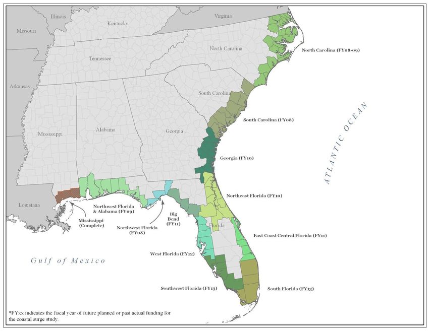
1975 - 1980                                     Image: FEMA Region III

Flood Insurance                              1980
   Rate Maps                              FEMA issues                                                                 2012 Biggert-
 (FIRMs) for ~                           “Users Manual                                1994 “Flood                     Waters Flood
      270                               for Wave Height                                Insurance                        Insurance
 communities                              Analysis” and                              Reform Act of                    Reform Act of
   published                                WHAFIS                                       1994”                             2012

                            1977                                1981 - 1990                          2005 Hurricane                      2012 Superstorm
                          National                            Improvements                               Katrina:                             Sandy
                        Academy of                           and additions to                          Remapping
                          Sciences                              the NAS                                  follows               Image: US Air Force
                      “Methodology                             Methodology                           throughout the
                      for Calculating                                                                Gulf Coast and
                        Wave Action                                                                     Southeast
                           Effects
                      Associated with
                       Storm Surges”

                                                                              Image: NASA

                  History   Methods & Models          Building Codes           CRS      LOMA/LOMR       BW-12
4
• “A program of flood insurance can promote the public interest by encouraging sound
      land use by minimizing exposure of property to flood losses …” (FEMA, 2004)
    • Enables property owners in participating communities to purchase insurance protection
      from the government against losses from flooding
    • More than 21,800 local governments participate in the NFIP
    • Three main elements
       • Hazard ID and mapping
       • Floodplain management criteria
       • Flood insurance

        History   Methods & Models   Building Codes   CRS   LOMA/LOMR   BW-12
5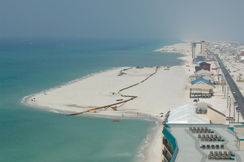
Step 2: Storm                                              Step 4: Overland
•Storm Rate and Storm                      Surge Modeling          •Combine Coupled Model               Wave Analysis     •Flood Insurance Rate Map
  parameter characterization                                         Results with Storm
• Storm Tracks                       • Detailed Mesh                 Characterization            • WHAFIS model
• JPM Development                      Development                 • JPM-OS
• JPM-OS Development                 • Coupled Hydrodynamic        • Account for Uncertainty
                                       and Wave Modeling           • Obtain SWEL

        Step 1: Storm                                                      Step 3: Return
                                                                                                                                      Output
       Characterization                                                   Period Analysis

               History         Methods & Models       Building Codes   CRS     LOMA/LOMR       BW-12
6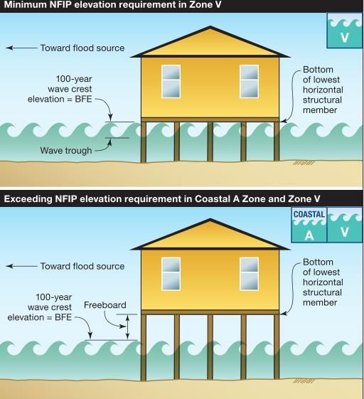
Historical Storm Central Radius to Forward Storm
(year) Pressure Maximum Speed Heading
• Analyze historic climatology for region Deficit
(hPa)
Winds
(km)
(m/s) (°N)
• Storm rate Notnamed (1944) 45 63 8.0 10
Notnamed (1945) 37 --- 5.8 62
• Storm characterization Notnamed (1946)
Notnamed (1947)
27
22
46
---
8.5
4.0
13
12
Notnamed2 (1947) 29 24 6.7 39
Notnamed (1948) 52 13 3.6 24
Notnamed2 (1948) 38 24 7.6 42
Easy (1950) 55 28 2.2 24
Love (1950) 23 --- 8.0 46
How (1951) 20 --- 7.2 81
Notnamed (1953) 28 --- 8.9 51
Hazel (1953) 23 --- 8.9 46
Judith (1959) 14 --- 5.8 45
Donna (1960) 75 44 4.0 338
Isbell (1964) 45 56 7.2 36
Abby (1968) 20 --- 4.0 27
Gladys (1968) 36 31 3.6 47
Floyd (1987) 20 --- 7.6 61
Keith (1988) 18 135 7.6 65
Marco (1990) 14 19 4.0 354
Gordon (1994) 18 148 4.0 27
Mitch (1998) 23 278 8.9 62
Irene (1999) 27 74 4.5 33
Gordon (2000) 24 46 4.9 21
Gabrielle (2001) 30 46 8.0 34
Charley (2004) 66 19 8.9 15
Wilma (2005) 60 56 7.6 47
Fay (2008) 19 37 2.7 10
Image: Condon & Sheng / Natural Hazards 62, 2 (2012) 345-373 Image: G. R. Toro et al. / Ocean Engineering 37 (2010) 114-124
History Methods & Models Building Codes CRS LOMA/LOMR BW-12
7
Image: Condon & Sheng / Ocean Engineering 43 (2012) 13-22                             Image: Condon & Sheng / Ocean Engineering 43 (2012) 13-22

    History     Methods & Models               Building Codes      CRS   LOMA/LOMR   BW-12
8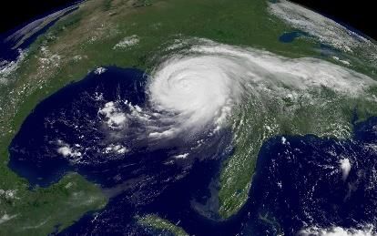
Image: FEMA Region IV

    • The conditional probability that a storm with the specific characteristics x will generate a flood elevation in
      excess of η
    • Infinite number of possible hypothetical storm tracks based on the multiple integral
    • Multiple integral is approximated as a summation over a discrete set of storm-parameter values (each term (i)
      corresponds to one combination of storm parameters
    • Need for optimal sampling techniques!

          History      Methods & Models   Building Codes   CRS   LOMA/LOMR   BW-12
9
• Optimal Sampling (OS)
     • Develop an optimal ensemble of storms
        which can adequately represent
        the inundation threat to a region
     • Based on the historical tracks & climatology
     • Cover the expected surge response
        in the region for any climatologically
         possible storm
     • Storm characteristics are varied for
        each track

        History   Methods & Models   Building Codes   CRS   LOMA/LOMR   BW-12
10
Traditional JPM BFE Optimal Storm BFE
• 46,800 simulations • 197 simulations
• Selecting combinations of storm
parameters and their weights to
minimize the number of
simulations needed
• An order of magnitude or more
reduction
Images: Condon & Sheng / Natural Hazards 62, 2 (2012) 345-373
History Methods & Models Building Codes CRS LOMA/LOMR BW-12
11Image: Condon & Sheng / Natural Hazards 62, 2 (2012) 345-373
• Use detailed, high resolution (10s of meters) numerical grids with dynamically coupled
hydrodynamic-wave modeling systems
• https://www.fema.gov/national-flood-insurance-program-flood-hazard-mapping/numerical-
models-meeting-minimum-requirement-0
History Methods & Models Building Codes CRS LOMA/LOMR BW-12
12• Calculation of still water elevation made at each grid cell
• At each cell, i peak surges each with an associated rate of occurrence is obtained
• Histogram of accumulated surge rate is constructed (at each cell) – approximation of surge height
density distribution
• Secondary error terms are accounted for by redistributing the contents of the bins in a
Gaussian pattern over neighboring bins
• astronomical tide level
• variations in the surge response caused by random variations in Holland B and departures of the
actual wind from the idealized modeled wind
• Random errors caused by lack of skill of the numerical modeling
• Develop modified histogram which is summed from the highest bin down to the
lowest, resulting in an estimate of the cumulative surge distribution
History Methods & Models Building Codes CRS LOMA/LOMR BW-12
13Image: A.W. Niedoroda et al. / Ocean Engineering 37 (2010) 82-90
Image: A.W. Niedoroda et al. / Ocean Engineering 37 (2010) 82-90
Image: Condon & Sheng / Natural Hazards 62, 2 (2012) 345-373
History Methods & Models Building Codes CRS LOMA/LOMR BW-12
14Using the updated stillwater elevations, overland wave hazard analysis is performed
to create FIRMS by:
1. Developing layout of transects
2. Performing storm induced erosion assessments and updating primary frontal
dune (PFD) determinations
3. 1-Dimensional overland wave height modeling
4. Wave runup modeling
History Methods & Models Building Codes CRS LOMA/LOMR BW-12
151. Developing layout of transects
• Physical factors (topography, bathymetry, shoreline orientation, land cover
data)
• Societal factors (variations in development and density)
• Field reconnaissance (verify placements, direct modeling efforts to focused
areas, hydraulic and/or flood control structures, maintenance or condition of
existing hydraulic structures, verification of land type data for wave
modeling)
History Methods & Models Building Codes CRS LOMA/LOMR BW-12
162. Performing storm induced erosion assessments and updating primary frontal dune (PFD) determinations
• Coastal Hazard Analysis Modeling Program (CHAMP) used to assess storm-induced beach & dune erosion (540 ft2 rule)
• 540 ft2 rule says that an average cross-sectional area of 540 ft2 (or 20 cyds volume per foot along the shore) is required
above the SWEL and seaward of the dune crest to prevent dune breaching or removal
• Remove the dune, if reservoir is less than 540 ft2
• Retreat the dune, if reservoir is more than 540 ft2
Image: FEMA
History Methods & Models Building Codes CRS LOMA/LOMR BW-12
173. 1-Dimensional overland wave height modeling
• Wave Height Analysis for Flood Insurance Studies (WHAFIS)
• Computes wave heights, wave crest elevations, flood insurance risk zone designations, and flood zone boundaries along
the transects
• Incident wave height can be specified or computed by WHAFIS based on fetch (no refraction, diffraction)
Image: FEMA
History Methods & Models Building Codes CRS LOMA/LOMR BW-12
184. Wave runup modeling
• Uprush of water from wave action on a shore barrier intercepting stillwater level
• Wave runup elevation is the value exceeded by 2% of the runup events
• RUNUP 2.0, ACES, and several others based on the site conditions
History Methods & Models Building Codes CRS LOMA/LOMR BW-12
19• FEMA will consider beach nourishment
if the project is significant and will be
maintained for many years
• Tall, large, and well-established with
longstanding vegetation
• FEMA may include the project in the
flood study if a community can
demonstrate the commitment and
resources to undertake long-term
maintenance of a beach nourishment
project
• Whether included in flood study or not,
may receive credit through CRS
• More info: 44 CFR 65.11
History Methods & Models Building Codes CRS LOMA/LOMR BW-12
20• Mapping of Coastal Hazard Areas
• Special Flood Hazard Area (SFHA)
• Land area covered by the floodwaters of the base flood.
• NFIP regulations are enforced and mandatory purchase of
flood insurance applies
• Zone VE
• Inundated by the 1-percent-annual-chance flood
• Areas subject to waves greater than 3 feet
• The primary frontal dune
• Zone AE
• Inundated by the 1-percent-annual-chance flood
• Wave height < 3 ft.
• Area of Moderate Wave Action (MoWA)
• 3 ft. > Wave height ≥ 1.5 ft.
• Limit of Moderate Wave Action (LiMWA)
• location of 1.5 foot wave height within coastal AE
zone
• Area of Limited Wave Action (MiWA)
• Wave height < 1.5 ft.
• Zone X
• Areas above the 1-percent-annual-chance flood level
Image: FEMA
History Methods & Models Building Codes CRS LOMA/LOMR BW-12
21Note that FEMA does not have a regulatory flood zone named the “Coastal A Zone”
• Two conditions for CAZ
1. Water depth sufficient to support waves
between 1.5 and 3.0 feet high
• Requires stillwater depths of 2 to 4 feet at the
site
2. Expectation that wave heights between
1.5 and 3.0 feet will occur during the
1% chance storm
• Requires wave heights at the shoreline
greater than 1.5 feet, sufficient water depth
between the shoreline and the building site
and few, if any obstructions that may block
Image: FEMA
or dampen the waves, between the shoreline
and the site
History Methods & Models Building Codes CRS LOMA/LOMR BW-12
22• 2010 FBC, Building
• Reference to ASCE 7 (for loads) and to ASCE
24 require the designer to determine if CAZ
conditions exist
• ASCE 24: “Area within a special flood
hazard, landward of a V Zone or landward of
an open coast without mapped V Zones. In a
CAZ, the principal source of flooding must be
astronomical tides, storm surges, seiches, or
tsunamis, not riverine flooding. During the
base flood conditions, the potential breaking
wave heights shall be greater than or equal to
1.5 ft.”
• ASCE 24 requires buildings to be treated
the same as buildings in coastal high
hazard areas (Zone V), with one exception
– openings are required in breakaway walls
Image: FEMA
History Methods & Models Building Codes CRS LOMA/LOMR BW-12
23• 2010 FBC, Residential
• R322.2 specifies that the CAZ applies
only if a LiMWA is delineated on the
FIRM or if a community otherwise
designates an area as subject to 1.5 to 3 ft.
wave conditions
• R322.2.1 specifies that if the CAZ has
been designated, then lowest floors shall
be elevated to or above the base flood
elevation plus 1 foot, or the design flood
elevation, whichever is higher
Image: FEMA
History Methods & Models Building Codes CRS LOMA/LOMR BW-12
24• Additional References
• ASCE 7
• ASCE 24
• FEMA P-499 Home Builder’s Guide to
Coastal Construction
• FEMA P-550, Recommended Residential
Construction for Coastal Areas: Building
on Strong and Safe Foundations
• FEMA P-55 Coastal Construction Manual
History Methods & Models Building Codes CRS LOMA/LOMR BW-12
25• Community Rating System
• Build Higher
• Map Amendments and Revisions via site specific analysis
History Methods & Models Building Codes CRS LOMA/LOMR BW-12
26Goals
• Reduce flood losses
• Facilitate accurate insurance ratings
• Promote awareness of the importance of
flood insurance
Image: FEMA
History Methods & Models Building Codes CRS LOMA/LOMR BW-12
27• ~ 460 communities in FL participate in NFIP
• 47% of those participate in CRS
Rank by Flood Ins. Policy Count Community Name Number of Flood CRS Class
(as of May 2012) Insurance Policies
1 Miami-Dade County 196,875 5
2 Lee County 88,954 5
3 Palm Beach County 72,536 5
4 Collier County 57,718 6
5 City of Miami 48,646 7
6 City of Miami Beach 47,379 6
7 Sarasota County 44,935 5
8 City of Ft. Lauderdale 42,989 7
9 Hillsborough County 40,881 5
10 City of St. Petersburg 38,056 6
History Methods & Models Building Codes CRS LOMA/LOMR BW-12
28• CRS encourages local governments to adopt
regulations that require the foundation design
in a CAZ comply with the more stringent
requirements applied to V Zones
• Up to 650 credit points are available for local
governments that map CAZ and regulate these
areas based on V Zone building standards
• Other points for engaging in any of 18
activities in four categories
• Public info
• Mapping and regulations
• Flood damage reduction
• Flood preparation Image: FEMA
History Methods & Models Building Codes CRS LOMA/LOMR BW-12
29Image: FEMA
History Methods & Models Building Codes CRS LOMA/LOMR BW-12
30• LOMA – Letter of Map Amendment
• An official amendment to the currently effective FIRM, which establishes that a subject
building or structure is no longer located in a SFHA. Issued by FEMA, a LOMA removes
a structure (not a property) from a SFHA
• LOMR – Letter of Map Revision
• An official revision to the currently effective FIRM. Issued by FEMA, a LOMR changes
flood zones, BFEs, and WCEs (wave crest elevations)
• LOMR-F – LOMR Based on Fill
• Similar to a LOMA, except a LOMA-F is submitted for properties on which fill has been
placed to raise a structure or lot to or above the BFE
History Methods & Models Building Codes CRS LOMA/LOMR BW-12
31• Typical project includes
• Collecting and reviewing available data
• Determining appropriate 100 year storm parameters
• Site visits to determine conditions along transects
• Modeling transects using FEMA CHAMP model
• Drawing proposed new flood zones
• FEMA approved models
• http://www.fema.gov/national-flood-insurance-
program-flood-hazard-mapping/numerical-models-
meeting-minimum-requirement-0
History Methods & Models Building Codes CRS LOMA/LOMR BW-12
32• Calls for increases in rates of subsidized flood insurance policies to more
accurately reflect the real flood risk to insured properties
• 5% fee for each policy will be assessed to contribute to the program’s reserve
fund
• Primary residences in SFHAs will be able to keep their subsidized rates unless
or until
• The property is sold
• The policy lapses
• You suffer severe, repeated, flood losses
• A new policy is purchased
History Methods & Models Building Codes CRS LOMA/LOMR BW-12
33• January 1, 2013
• Owners of subsidized policies on non-primary/secondary residences in a SFHA saw a 25%
increase until rates reflect true risk
• October 1, 2013
• Owners of subsidized policies on property that has experienced severe or repeated flooding saw a
25% rate increase annually until rates reflect true risk
• Owners of subsidized policies on business/non-residential properties in a SFHA saw a 25% rate
increase annually until rates reflect true flood risk
• Beginning Late 2014 at the earliest
• Current grandfather procedure provides eligible property owners the option of using risk data
from previous FIRMs if a policyholder maintained continuous coverage through a period of a
FIRM revision or if a building was constructed “in compliance” with the requirements to the
zone and BFE reflected on a previous FIRM
• Upon a revised or updated flood map, BW-12 requires adjustment and phase in rates over 5 years
“to accurately reflect the current risk of flood to such property.”
History Methods & Models Building Codes CRS LOMA/LOMR BW-12
34• Only 20% of NFIP policies receive subsidies
• FEMA analysis: 7% of policies in FL saw immediate rate increases under initial
implementation
• FL Office of Insurance Regulation has approved two companies already selling
private flood insurance
• Continues to be a dynamic situation
History Methods & Models Building Codes CRS LOMA/LOMR BW-12
35• Insurance rates will be going up
• New modeling / mapping efforts continue to evolve
• Coastal building code requirements will get more stringent
• There are ways to reduce premiums: CRS, building higher, LOMA/LOMR
History Methods & Models Building Codes CRS LOMA/LOMR BW-12
36Thank You Special Thank You to Tucker Mahoney with FEMA for her input
3/13/2014
            History   Methods & Models   Building Codes   CRS   LOMA/LOMR   BW-12
38
• Area of Limited Wave Action (MiWA) – An area of special flood hazard landward
of the Area of Moderate Wave Action that is subject to wave heights less than 1.5
feet. These areas are designated Zone AE on a FIRM.
• Area of Moderate Wave Action (MoWA) – An area of special flood hazard
landward of the Coastal High Hazard Area that is subject to wave heights that are
less than 3 feet, but greater than or equal to 1.5 feet. These areas are designated
Zone AE on a FIRM and area sometimes referred to as “coastal AE zones.”
• Base Flood Elevation (BFE) – The elevation of a flood having a 1-percent chance
of being equaled or exceeded in any given year.
• Coastal BFEs – The 1-percent-annual-chance flood elevations shown on a FIRM
within the Coastal High Hazard Area.Coastal BFEs can be calculated using the
following equation: Stillwater Elevation + Wave Height = Coastal BFE
• Coastal High Hazard Area (CHHA) – An area of special flood hazard extending
from offshore to the inland limit of a primary frontal dune along an open coast
and any other area subject to high-velocity wave actions from storms or seismic
sources.
3/13/2014
History Methods & Models Building Codes CRS LOMA/LOMR BW-12
39• High-Velocity Wave Action - A condition in which wave heights or wave runup
depths are greater than or equal to 3.0 feet.
• Limit of Moderate Wave Action (LiMWA) – A line within the SFHA desidnated
Zone AE on a FIRM that marks the inland limit of the area inundated by the 1-
percent-annual-chance, 1.5-foot breaking wave. The LiMWA is provide on the
FIRM, for informational purposes, because these moderate waves can cause
damage to structures; the damage would not be as severe as the damage caused
by the 1-percent-annual-chance, 3-foot breaking waves.
• Preliminary BFEs – The BFEs that are shown on the Preliminary FIRM and in the
Preliminary FIS report before the 90-day appeal period begins.
• Primary Frontal Dune (PFD) – A continuous or nearly continuous mound or ridge
of sand with relatively steep seaward and landward slopes immediately landward
and adjacent to the beach and subject to erosion and overtopping from high
tides and waves during major coastal storms. The inland limit of the PFD occurs at
the point where there is a distinct change from a relatively steep slope to a
relatively mild slope.
3/13/2014
History Methods & Models Building Codes CRS LOMA/LOMR BW-12
40• Stillwater Flood Elevation (SWEL) – Projected elevation that floodwaters would
assume, referenced to NGVD29, NAVD88, or other datum, in the absence of
waves resulting from wind or seismic effects.
• Stillwater Flood Level (SWFL) – Rise in the water surface above normal water
level on the open coast due to the action of wind stress and atmospheric
pressure on the water surface.
• Storm Surge – The water that is pushed toward land from the high winds of a
major storm, such as a hurricane.
• Transect – Cross section taken perpendicular to the shoreline to represent a
segment of coast with similar characteristics.
• Wave – A ridge, deformation, or undulation of the water surface.
• Wave Height – The vertical distance between the highest part of a wave (crest)
and the lowest part of the wave (trough).
3/13/2014
History Methods & Models Building Codes CRS LOMA/LOMR BW-12
41• Special Flood Hazard Area (SFHA)
• The land area covered by the floodwaters of the base flood. Where NFIP’s floodplain management
regulations must be enforced and the area where the mandatory purchase of flood insurance
applies (Two primary zones: VE and AE)
• VE Zone
• Coastal High Hazard areas where wave action and/or high-velocity water can cause structural
damage during the base flood. Subdivided into elevation zones with BFEs assigned. Must meet
one or more of the following criteria
1. The wave runup zone occurs where the (eroded) ground profile is 3.0 feet or more below the 2-percent
wave runup elevation
2. The wave overtopping splash zone is the area landward of the crest of an overtopped barrier, in cases
where the potential 2-percent wave runup exceeds the barrier crest elevation by 3.0 feet or more
3. The breaking wave height zone occurs where the 3-foot or greater wave heights could occur (this is the
area where the wave crest profile is 2.1 feet or more above the total Stillwater level)
4. The primary frontal dune zone, as defined in 44 CFR Section 59.1 of the NFIP regulations
• VE Zone boundary shown on the FIRM is defined as the farthest inland extent of any of the four
criteria listed
3/13/2014
History Methods & Models Building Codes CRS LOMA/LOMR BW-12
42• AE Zone
• Areas of inundation by the 1-percent-annual-chance flood, including areas with the 2-
percent wave runup elevation less that 3.0 feet above the ground and areas with wave
heights less than 3.0 feet. These areas are subdivided into elevation zones with BFEs
assigned. The AE zone will generally extend inland to the limit of the 1-percent-annual-
chance flood SWEL
• X Zone
• Areas above the 1-percent-annual-chance flood level. On the FIRM, a shaded X zone
area is inundated by the 0.2-percent-annual-chance flood and an unshaded X zone area
is above the 0.2-percent-annual chance flood
3/13/2014
History Methods & Models Building Codes CRS LOMA/LOMR BW-12
433/13/2014
History Methods & Models Building Codes CRS LOMA/LOMR BW-12
442. Performing storm induced erosion assessments and updating primary frontal dune
(PFD) determinations
3/13/2014
History Methods & Models Building Codes CRS LOMA/LOMR BW-12
45• For a LOMA to be issued to:
• Remove a structure from the SFHA:
• NFIP regulations require that the lowest adjacent grade be at or above the BFE To
• Remove an entire lot from the SFHA:
• NFIP regulations require the lowest point on the lot be at or above BFE
• Necessary Info to complete MT-EZ
• A copy of the Plat Map for the property or a copy of the Deed for the
property
• A certified site plan showing the precise location of the structure
• Copy of the FIRM panel and FIS report
• Elevation Certificate
History Methods & Models Building Codes CRS LOMA/LOMR BW-12• LOMRs change flood zones
• Does not reduce risk, but does reduce how risk is reflected on a map
reduced premiums
• Necessary info to complete MT-2
• Overview and Concurrence Form
• Coastal Analysis Form
• Coastal Structures Form
• Payment Form
• Requester must:
• Provide all of the data used in determining the revised floodplain boundaries, flood
profiles, floodway boundaries, etc.
• Provide all data necessary to demonstrate that the physical modifications to the
floodplain meet NFIP regulations, have been adequately designed to withstand the
impacts of the 1% annual chance flood event, and will be adequately maintained;
• Demonstrate that the revised information (e.g., hydrologic and hydraulic analyses and
the resulting floodplain and floodway boundaries) is consistent with the effective FIS
information.
History Methods & Models Building Codes CRS LOMA/LOMR BW-12• Coastline to be Revised
• Effective FIS
• Type of analyses used for the effective FIS (approximate or detailed wave parameter computations)
• Revised Analysis
• Certified topographic info
• Structure plans
• Survey notes
• Storm surge data
• Meteorological data
• All equations / models must be referenced
• Descriptions / sketches of transect profiles for revised erosion, wave height, wave runup, and wave
overtopping analyses
• Wave runup and overtopping
• Results
• Location of coastal high hazard area boundaries
• Maximum wave height elevation
• Maximum wave runup elevation
• Mapping Requirements
• Certified topographic map showing the information indicated in t
• Current FIRM annotated to show the revised 1% annual chance floodplain boundaries
History Methods & Models Building Codes CRS LOMA/LOMR BW-12• An official revision to an effective NFIP map stating FEMA’s determination concerning
whether a structure or parcel has been elevated on fill above the BFE and is,
therefore, excluded from the SFHA
• When fill material has been placed after the first FIRM of the area was established
Typically a 2 – step process
1. A Conditional Letter of Map Revision based on Fill (CLOMR-F) is submitted to FEMA
• Shows proposed grading plan with fill elevations, structure elevations, and existing flood
elevations
• FEMA determines if proposed fill is sufficient to remove structures from the floodplain
2. Once approved and fill is placed, a LOMR-F is submitted
• Contains as-built info and elevations, which should be consistent with CLOMR-F
History Methods & Models Building Codes CRS LOMA/LOMR BW-12• NFIP minimum requirements for buildings
do not recognize the risk associated with
waves less than 3 ft. high
• Two alternatives to adopt CAZ provisions
1. Application of Zone V standards within the
CAZ if FEMA has delineated a LiMWA
2. Application of Zone V standards within an
area designated by the community as
“Coastal A Zone.” The community selects
the area, which may be done by specifying a
distance inland from shore, by identifying a
specific geographic area, or by delineating
specific areas on a map
Image: FEMA Image: FEMA
History Methods & Models Building Codes CRS LOMA/LOMR BW-12
503. 1-Dimensional overland wave height modeling
• WHAFIS Transect Considerations
• Should be placed along any shoreline across which damaging waves may propagate during the
base flood
• All open coast shorelines and other shorelines along large sheltered bodies of water subject to storm
surge flooding (bays, sounds, and estuaries)
• Orientated in the direction that waves propagate across the 0.0 ft. contour (from water to land)
• Balance between representing coastal flood and severe wave conditions in developed upland
areas and study resources
• WHAFIS Input Considerations
• Typically the base (1%) SWEL + Setup and controlling wave height at the transect start
• Special cases where more detailed study is needed exist (sheltered bays, islands, etc.)
• Vegetation, Coastal Structures, Buildings must be specified
History Methods & Models Building Codes CRS LOMA/LOMR BW-12
51You can also read