Flood Risk Assessment - Galway County Council Housing Development Gort Uí Lochlainn & Coill Bhruchláin, Moycullen, Co. Galway - Galway County ...
←
→
Page content transcription
If your browser does not render page correctly, please read the page content below
Galway County Council
                   Housing Development
Gort Uí Lochlainn & Coill Bhruchláin, Moycullen, Co. Galway
                Flood Risk Assessment

                                                          www.tobin.ie
Housing Development, Gort Uí Lochlainn & Coill Bhruchláin, Moycullen, Co. Galway

Flood Risk Assessment
                                          Document Control Sheet
Document Reference        10578 - TR01 FRA Moycullen Draft.docx
Report Status             Issued
Report Date               May 2020
Current Revision          A
Client:                   Galway City Council
Client Address:           1st Floor,
                          Fairgreen House,
                          Fairgreen Rd,
                          Galway,
                          H91 AXK8
Project Number            10578

Galway Office                  Dublin Office              Castlebar Office             London Office
Fairgreen House,               Block 10-4,                Market Square,               17 Bowling Green Lane,
Fairgreen Road,                Blanchardstown             Castlebar,                   Clerkenwell,
Galway,                        Corporate Park,            Mayo,                        London,
H91 AXK8,                      Dublin 15,                 F23 Y427,                    EC1R 0QB,
Ireland.                       D15 X98N,                  Ireland.                     United Kingdom.
                               Ireland.
Tel: +353 (0)91 565 211        Tel: +353 (0)1 803 0406    Tel: +353 (0)94 902 1401     Tel: +44 (0)203 915 6301

                                                              Reviewed                   Authorised
Revision         Description         Author:       Date                       Date                        Date
                                                                 By:                        by:
  D01              Draft               BM        07/2019         BD          08/2019        BD          08/2019
  D02          Updated draft           BM        12/2020        MG            12/20         BD          12/2020
   A        Issued for Planning        CK        05/2021         SB          05/2021        MG          05/2021

                                            TOBIN Consulting Engineers

Disclaimer
This Document is Copyright of TOBIN Consulting Engineers Limited. This document and its contents have been
prepared for the sole use of our Client. No liability is accepted by TOBIN Consulting Engineers Limited for the use
of this report, or its contents for any other use than for which it was prepared.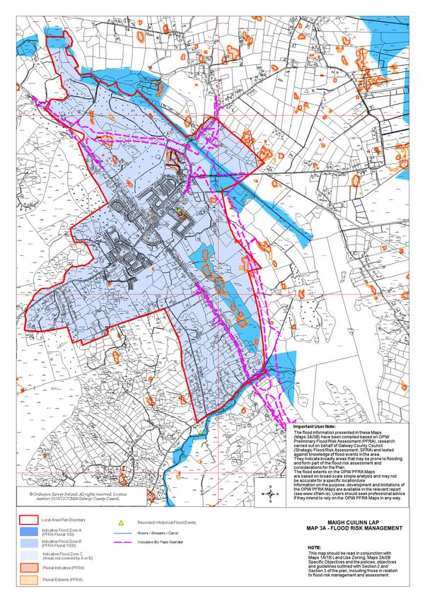
Table of Contents
1     Introduction ......................................................................................................... 1
2     Historical Flooding & FLOOD MAPS.................................................................... 3
2.1   OPW FLOOD MAPS............................................................................................. 3
2.2   OPW PRLIMINARY FLOOD RISK ASSESSMENT (PFRA) MAPS ......................... 4
3     Planning & Flood Risk Management Guidelines ................................................... 6
3.1   THE PLANNING SYSTEM & FLOOD RISK MANAGEMENT GUIDELINES ......... 6
3.2   THE FLOOD RISK MANAGEMENT CLIMATE CHANGE ADAPTION PLAN ...... 7
3.3   GALWAY COUNTY DEVELOPLEMT PLAN (2015-2021) ................................... 8
3.4   MAIGH CUILINN LOCAL AREA PLAN 2013-2019 ............................................. 8
4     APPRAISAL OF EXISTING DRAINAGE INFRASTRUCTURE ............................. 11
5     FLOOD RISK ASSESSMENT............................................................................... 12
5.1   FLUVIAL FLOOD RISK ....................................................................................... 12
5.2   GROUNDWATER FLOOD RISK ........................................................................ 12
5.3   PLUVIAL FLOOD RISK ....................................................................................... 13
5.4   IMPACT OF THE DEVELOPMENT ELSEWHERE .............................................. 13
5.5   THE JUSTIFICATION TEST ................................................................................ 13
6     CONCLUSION.................................................................................................... 14

                                                                                                            -i-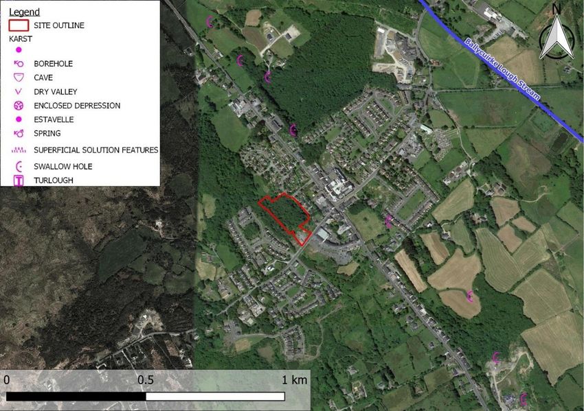
Table of Figures
Figure 1.1 – Site Location .......................................................................................................................... 2

Figure 1.2 - Proposed Site Development Plan ........................................................................................ 2

Figure 2.1 - Extract from National Flood Hazard Mapping database ................................................... 3

Figure 2.2 - Indicative Flood Mapping from OPW PFRA Study ............................................................ 4

Figure 3.1 – Extract from Maigh Cuilinn LAP 2013-2019, Map 3B Flood Risk Management Town
Centre ........................................................................................................................................................ 10

Figure 4-1 Sketch showing local drainage infrastructure in vicinity of subject site .......................... 11

Figure 4.1 - Karst features in vicnity of proposed site [GSI database]................................................ 12

                                                                                                                                      - ii -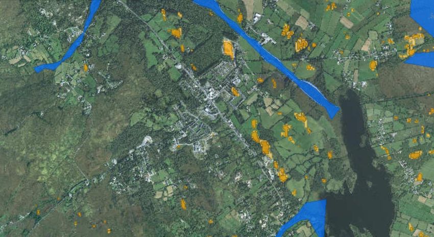
1      INTRODUCTION
TOBIN Consulting Engineers have been commissioned to provide engineering and environmental
consultancy services for the proposed construction of 31 housing units at Gort Uí Lochlainn & Coill
Bhruchláin, Mountain Road, Moycullen, Co. Galway (Figure 1.1 & Figure 1.2).

This preliminary Flood Risk Assessment (FRA) has been prepared in accordance with a Stage 2
Initial Flood Risk Assessment as defined by the guidelines produced by the Department of
Environment, Heritage and Local Government (DoEHLG), The Planning System and Flood Risk
Management Guidelines for Planning Authorities, 2009 as follows:

        “to confirm sources of flooding that may affect a plan area or proposed development site,
       to appraise the adequacy of existing information and to scope the extent of the risk of
       flooding which may involve preparing indicative flood zone maps. Where hydraulic models
       exist the potential impact of a development on flooding elsewhere and of the scope of
       possible mitigation measures can be assessed. In addition, the requirements of the detailed
       assessment should be scoped.”

The proposed residential development is located along Baile Ard (L1320) just off of the N59 in
Moycullen, Co. Galway (see Figure 1.1). The greenfield site is approximately 17.307ha in area.
Existing ground elevations vary from 35.14mOD to 39mOD.

The aim of this FRA is to “appraise the adequacy of existing information” (extract from PSFRM
Guidelines, see above) to identify the risk, if any, of flooding in relation to the proposed
development.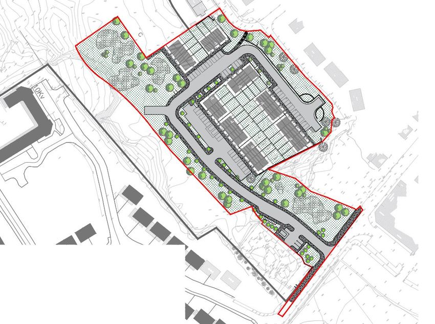
Figure 1.1 – Site Location

                                        To
                                     Clifden
                                               N59

                                                            To
                                                          Galway

                                                                   N59

                  Figure 1.2 - Proposed Site Development Plan

Legend

         Proposed Development Site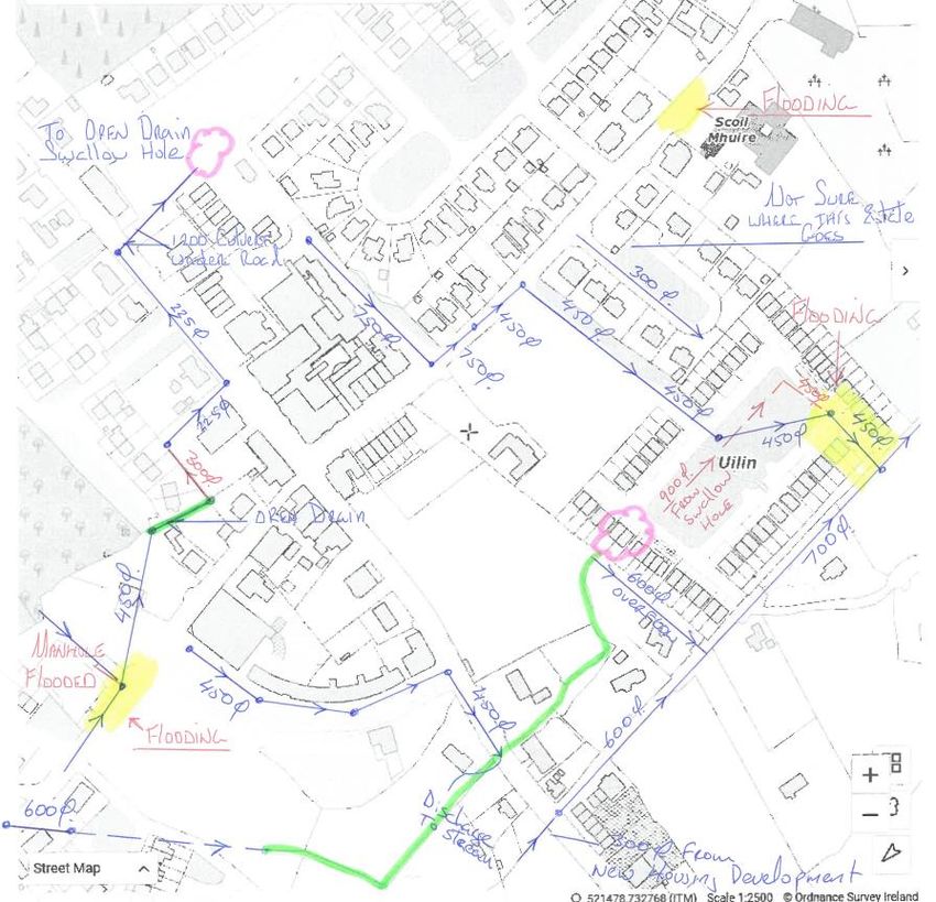
2         HISTORICAL FLOODING & FLOOD MAPS
2.1           OPW FLOOD MAPS

The OPW’s online National Flood Hazard Mapping database1 provides information on reported
floods, in the form of reports, photos and newspaper articles.

The database does not provide any record of flood events occurring at the proposed development
site (see Figure 2.1).

The proposed site is approximately 370m from a recurring flood event caused by a turlough. This
flood report can be found in Appendix 1.

With existing ground elevations at the proposed development site of 35.0mOD or higher, the
subject site is at least 18.0m above the ground elevations at the location of the recurring flood event
(approximately 17.0mOD).

                  Figure 2.1 - Extract from National Flood Hazard Mapping database

                                                                              Recurring Flood Event
                                                                              Flood Source; Turlough
                                                                              See Appendix 1

                       Proposed Development
                       Site Location

                                                                               Approx. 370m

1
    www.floodmaps.ie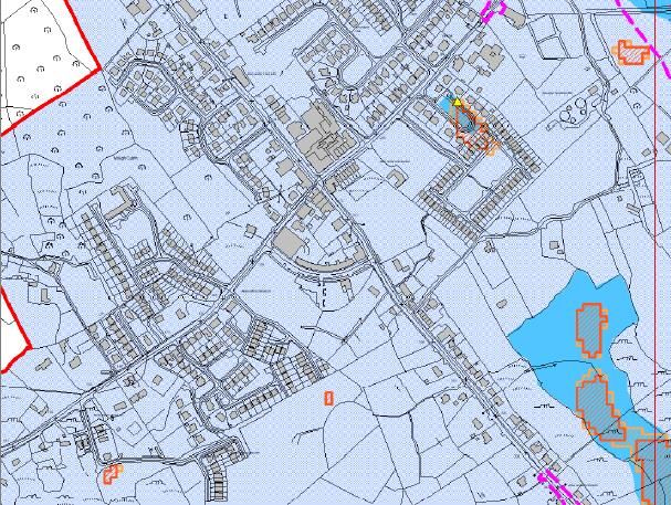
2.2            OPW PRLIMINARY FLOOD RISK ASSESSMENT (PFRA) MAPS

In 2009 the OPW produced a series of maps to assist in the development of a Preliminary Flood
Risk Assessment (PFRA) throughout the country. These maps were produced from a number of
sources. It should be noted that “the flood extents shown on these maps are based on broad-scale
simple analysis and may not be accurate for a specific location” 2.

Figure 2.2 gives an overview of the indicative flood extents in the vicinity of the subject site.

                       Figure 2.2 - Indicative Flood Mapping from OPW PFRA Study

                                                          Predicted Pluvial             Predicted Fluvial
                                                          Flood Extents                 Flood Extents

                                      Approx. 460m

                                                                                    Approx. 880m

                                                                                    Approx. 370m
               Proposed Development
               Site Location                                                        Approx. 410m

                                                       Predicted Pluvial
                                                       Flood Extents

Fluvial Flood Risk

The predicted flood extents at the subject site are shown in Figure 2.2. It should be noted that these
flood extents are for the current probability of flooding and specifically exclude any allowance for
climate change.

The PFRA indicative flood mapping of the area does not identify any areas as being liable to fluvial
(river) flooding in the vicinity of the proposed site. The indicative flood mapping shows the proposed
site is located approximately 880m from the nearest fluvial flood extents (see Figure 2.2). With
existing ground elevations of 35.0mOD or higher, the subject site is at least 26.0m above the
estimated 1000 year flood level in the Ballycuirke Lough Stream (9.0 mOD derived from the PFRA
mapping).

Pluvial Flood Risk

Pluvial modelling was carried out by HR Wallingford in November 2010 as part of the PFRA study.
The 100- and 1000-year flood extents were generated by analysing 1, 3, 6, and 24-hour rainfall
events. The design storm rainfall was applied to the National Digital Terrain Model (DTM) with an
allowance for infiltration based on the soil type in the area.

2
    The National Preliminary Flood Risk Assessment (PFRA) Overview Report, OPW (March 2012)
The DTM used for the PFRA study’s flood plain mapping was generated from RADAR based
technology in 2007 and is stated to have a 5m horizontal resolution (re-sampled to 10m resolution)
and 0.01m vertical resolution, to a quoted vertical accuracy of 0.5m RMSE 3. The accompanying
report to the PFRA notes that the process “due to the scale of analysis, has not taken into account
local drainage structures such as culverts through embankments or other local drainage that would
not be resolved in the DTM at a national scale”.

The PFRA pluvial flood maps were also adapted by the OPW to show only the extents where the
flood depths were greater than 200mm (on the basis that depths lower than this would not cause
significant damage given door-step levels above ground level) 4.

The analysis carried out by HR Wallingford as part of their PFRA study indicates that pluvial
flooding (ponding of surface water) is not likely to occur within the proposed residential
development site. The PFRA flood mapping indicates that the proposed site is located
approximately 370m from the nearest pluvial flood extents (see Figure 2.2).

Groundwater Flood Risk

As part of the PFRA study indicative groundwater flood mapping was produced by Mott MacDonald
Ltd. A model-based approach to generate groundwater flood extents was not possible due to the
lack of available data. Therefore, the following methods were used:
       1)      “The use of existing mapping of past groundwater flood events (e.g., from 1994/95, and
               late 2009), developed from ground-based observation, aerial photography or satellite
               imagery and the maximum extents observed”;
       2)      “The delineation of flood extents around turloughs based on an assumed height of
               flooding of 4m above the base elevation of the turlough (the median of observed ranges)
               using the OPW’s national DTM, with manual adjustment to ensure pragmatic extents”;
       3)      “The use of records of past groundwater flood events to validate or adjust the flood
               extents derived using the other approaches”.

“It should be noted that due to the absence of a model-based approach, only one set of flood extents
were generated, with no specific event probability (although where observed flood data was used,
these are likely to represent quite extreme events).”5

The PFRA mapping did not indicate any sources of groundwater flooding in the vicinity of the
proposed residential development site (see Figure 2.2).

3
    National Pluvial Screening Project for Ireland (HR Wallingford, November 2012)

4
    The National Preliminary Flood Risk Assessment (PFRA) Overview Report (OPW, March 2012)

5
    The National Preliminary Flood Risk Assessment (PFRA) Overview Report (OPW, March 2012)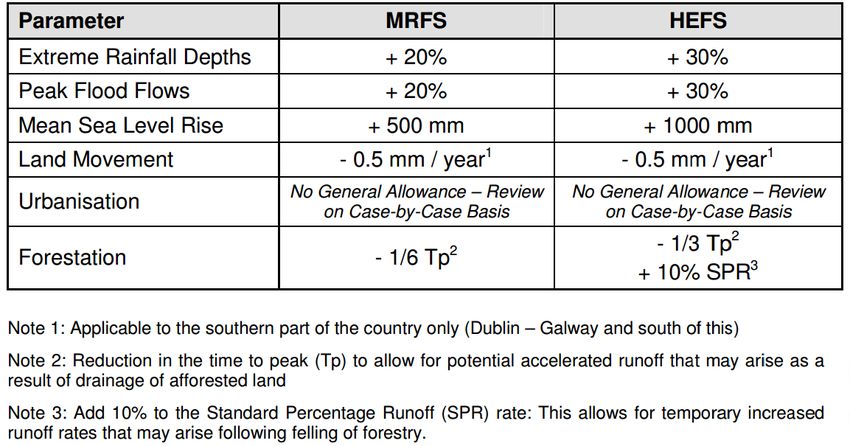
3       PLANNING & FLOOD RISK MANAGEMENT GUIDELINES
This section of the report considers the following plans and guidance documents:
    • The Planning System and Flood Risk Management Guidelines (OPW & DOEHLG 2009)
    • The Flood Risk Management Climate Change Adaptation Plan (OPW 2015)
    • The Galway County Development Plan 2017-2023
    • Maigh Cuilinn Local Area Plan 2013-2019

3.1         THE PLANNING SYSTEM & FLOOD RISK MANAGEMENT GUIDELINES

The ‘The Planning System and Flood Risk Management’ (PSFRM) guidance document, published in
2009 by The Department of Environment, Heritage and Local Government (DoEHLG) and the
Office of Public Works (OPW), discuss flood risk in terms of three flood zones. It also identifies
vulnerability classes for development in order to define what type of development is suitable within
what flood zone and when the Justification Test should be applied.

The flood zones, vulnerability classes and requirement for the Justification Test are summarised in
Table 1.

 Table 1 Matrix of vulnerability versus flood zone to illustrate appropriate development and that
         are required to meet the Justification Test (Extract from the PSFRM Guidelines)

                                              Recommendation based on Vulnerability of Development
Flood        Probability of Flooding
Zone            (Return Period)               Highly Vulnerable or         Less           Water
                                             Essential Infrastructure   Vulnerable      Compatible

                  High Probability
         (more frequent than 1% or 1 in                                 Justification
    A                                           Justification Test                      Appropriate
         100-yr for river flooding or 0.5%                                 Test
         or 1 in 200 for coastal flooding)

               Moderate Probability
         (between 0.1% or 1 in 1000 and
         1% or 1 in 100 for river flooding
    B                                           Justification Test      Appropriate     Appropriate
          and between 0.1% or 1 in 1000
           year and 0.5% or 1 in 200 for
                 coastal flooding)

                  Low Probability
    C                                             Appropriate           Appropriate     Appropriate
         (less frequent than 1 in 1000-yr)

The PSFRM Guidelines state that ‘dwelling houses’, such as the proposed development which is the
subject of this flood risk assessment, are classified as “highly vulnerable” development in terms of
their sensitivity to flooding. The proposed development has been assessed using the 1000-yr flood
event.
3.2 THE FLOOD RISK MANAGEMENT CLIMATE CHANGE ADAPTION PLAN
The Flood Risk Management Climate Change Adaptation Plan (published May 2015) has been
prepared under the remit of the National Climate Change Adaptation Framework. It sets out the
policy on climate change adaptation of the Office of Public Works (OPW), the lead agency for flood
risk management in Ireland, based on a current understanding of the potential consequences of
climate change for flooding and flood risk in Ireland, and the adaptation actions to be implemented
by the OPW and other responsible Departments and agencies in the flood risk management sector.
The document recommends two future flood risk scenarios for considering future implications of
factors, including climate change, in relation to future flooding. The Mid-Range Future Scenario
(MRFS) recommends a “likely” future scenario while the High-End Future Scenario (HEFS)
represents a more “extreme” future scenario. Table 2 sets out the allowances for both scenarios.
Table 2 Allowances in Flood Parameters for the Mid-Range and High-End Future Scenarios
For the purpose of this flood risk assessment, we have assessed the proposed development against
the Mid-Range Future Scenario as it represents a likely future scenario.3.3 GALWAY COUNTY DEVELOPLEMT PLAN (2015-2021)
Chapter 8 of the 2015-2021 County Development Plan (CDP) deals with the area of flood risk.
The following are the key policies described in the CDP pertaining to flood risk:
Policy FL 1 “It is the policy of Galway County Council to support, in co-operation with the OPW,
the implementation of the EU Flood Risk Directive (2007/60/EC), the Flood Risk
Regulations (SI No. 122 of 2010) and the DEHLG/OPW publication The Planning
System and Flood Risk Management Guidelines (2009) (and any
updated/superseding legislation or policy guidance). Galway County Council will
also take account of the Shannon International and Western Catchment Flood Risk
Assessment and Management Studies.”
Policy FL 4 “The Council shall implement the key principles of flood risk management set out in
the Flood Risk Management Guidelines as follows:
(a) Avoid development that will be at risk of flooding or that will increase the
flooding risk elsewhere, where possible;
(b) Substitute less vulnerable uses, where avoidance is not possible; and
(c) Mitigate and manage the risk, where avoidance and substitution are not
possible.
Development should only be permitted in areas at risk of flooding when there are no
alternative, reasonable sites available in areas at lower risk that also meet the
objectives of proper planning and sustainable development.
Development in areas which have the highest flood risk should be avoided and/or
only considered in exceptional circumstances (through a prescribed Justification
Test) if adequate land or sites are not available in areas which have lower flood risk.”
3.4 MAIGH CUILINN LOCAL AREA PLAN 2013-2019
The Maigh Cuilinn Local Area Plan takes due consideration of The Planning System and Flood Risk
Management: Guidelines for Planning Authorities 2009, the flood risk mapping available from the
PFRA and the recommendations emanating from the Strategic Flood Risk Assessment for County
Galway.
Galway County Council has carried out a Strategic Flood Risk Assessment (SFRA) for County
Galway, including a specific assessment for the Maigh Cuilinn Plan Area. As part of the SFRA, the
historic flood risk areas have been identified and a number of local level assessments have also been
carried out, including local knowledge of flood extents and site walkovers.
The SFRA generally confirms the flood extents identified in the OPW Preliminary Flood Risk
Assessment mapping for Maigh Cuilinn. The Local Area Plan identifies Flood Zones in accordance
with the Guidelines using data from the PFRA and SFRA (see Figure 3.1).
Section 3.6.2 Policies and Objectives of the Maigh Cuilinn Local Area Plan 2013-2019 deals with
flood risk management and assessment.
Policy UI 2 “It is the policy of Galway County Council to support, in co-operation with
the OPW, the implementation of the EU Flood Risk Directive (2007/60/EC),
the Flood Risk Regulations (SI No. 122 of 2010) and the DoEHLG/OPW
publication The Planning System and Flood Risk Management Guidelines for
Planning Authorities 2009 (or any updated/superseding legislation or policyguidance). Galway County Council will also take account of the OPW
Catchment Flood Risk Management Plans (CFRAMs), Preliminary Flood
Risk Assessment (PFRA) and the Strategic Flood Risk Assessment for
County Galway 2012 and any recommendations and outputs arising from
same that relate to or impact on the Plan Area”
Objective UI 8 - Flood Risk Management and Assessment
“Ensure the implementation of the DoEHLG/OPW publication The Planning
System and Flood Risk Management Guidelines for Planning Authorities
2009 (or any updated/superseding document) in relation to flood risk
management within the Plan Area. This will include the following:
1. Avoid, reduce and/or mitigate, as appropriate in accordance with The
Planning System and Flood Risk Management Guidelines for Planning
Authorities 2009, the risk of flooding within the flood risk.
2. Development proposals in areas where there is an identified or potential
risk of flooding or that could give rise to a risk of flooding elsewhere may
be required to carry out a Site-Specific Flood Risk Assessment, and
Justification Test where appropriate, in accordance with the provisions
of The Planning System and Flood Risk Management Guidelines for
Planning Authorities 2009, (or any superseding document). Any flood
risk assessment should include an assessment of the potential impacts of
climate change, such as an increase in the extent or probability of
flooding, and any associated measures necessary to address these
impacts.
3. Development that would be subject to an inappropriate risk of flooding
or that would cause or exacerbate such a risk at other locations shall not
normally be permitted
4. Where certain measures proposed to mitigate or manage the risk of
flooding associated with new developments are likely to result in
significant effects to the environment or Natura 2000 sites downstream,
such measures will undergo environmental assessment and Habitats
Directive Assessment, as appropriate.
Objective UI 9 - Flood Zones and Appropriate Land Uses (Refer to Map 3A/3B, Appendix 2)
Protect Flood Zone A and Flood Zone B from inappropriate development
and direct developments/land uses into the appropriate Flood Zone in
accordance with The Planning System and Flood Risk Management
Guidelines for Planning Authorities 2009 (or any superseding document)
and the guidance contained in DM Guidance UI 1- Flood Zones and
Appropriate Land Uses. Where a development/land use is proposed that is
inappropriate within the Flood Zone, then the development proposal will
need to be accompanied by a Development Management Justification Test
and Site-Specific Flood Risk Assessment in accordance with the criteria set
out under with The Planning System and Flood Risk Management Guidelines
for Planning Authorities 2009. In Flood Zone C, where the probability of
flooding is low (less than 0.1%, Flood Zone C), the developer should satisfy
him or herself that the probability of flooding is appropriate to the
development being proposed.
Objective UI 11 – Specific Flood Risk Locations (Refer to Map 3A/3B, Appendix 2)
Planning applications on lands identified within pluvial PFRA areas outside
of Indicative Flood Zone A on Map 3A/3B, shall be accompanied by a Site
Specific Flood Risk Assessment that corresponds with that outlined under
Chapter 5 “Flooding and Development Management” of The Planning
System and Flood Risk Management Guidelines for Planning Authorities2009). Such assessments shall be prepared by suitably qualified experts with
hydrological experience and shall quantify the risks and effects of any
necessary mitigation, together with the measures needed or proposed to
manage residual risks.
Objective UI 12 – Lands Transected by Flood Zones
In the case of lands transacted by the outer boundary of Indicative Flood
Zone A or B, where it can be demonstrated to the satisfaction of the Planning
Authority that the outer boundary does not reflect local topographical
and/or flood path conditions, the Planning Authority may consider the
extension of a zone that outside of the indicative flood zone area into this
area, to an extent that is generally less than the existing area, subject to the
submission of a Site Specific Flood Risk Assessment and Justification Test as
appropriate and the developer satisfying the Planning Authority and him or
herself that the probability of flooding is appropriate to the development
being proposed and will not increase flood risk elsewhere.”6
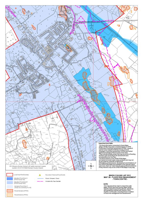
Figure 3.1 – Extract from Maigh Cuilinn LAP 2013-2019, Map 3B Flood Risk Management Town
Centre
Local Area Plan Boundary
Indicative Flood Zone A
(PFRA FLUVIAL 100)
Proposed Development
Site Location Indicative Flood Zone B
(PFRA FLUVIAL 1000)
Indicative Flood Zone C
(Areas not covered by A or B)
Pluvial Indicative (PFRA)
Pluvial Extreme (PFRA)
Map 3A/3B - Flood Risk Management Town Centre, in the Maigh Cuilinn LAP 2013-2019 (Appendix
2) indicates that the proposed development site is in Flood Zone C, i.e. that there is less than a 0.1%
probability of the site flooding.
6
Maigh Cuilinn Local Area Plan 2013-2019, Forward Planning, Galway County Council (April 2013)4 APPRAISAL OF EXISTING DRAINAGE INFRASTRUCTURE
A topographical survey of the site and local drainage infrastructure was carried out by TOBIN in
October 2020.
As shown in Figure 4-1, stormwater drainage infrastructure in Moycullen is comprised of sewers
(shown in blue with diameters in mm) and open channels (highlighted green), discharging to a
number of swallow holes (circled pink).
Based on anecdotal evidence, minor pluvial flooding occurs at a number of areas in the village, areas
shaded yellow in sketch below. This includes minor ponding on the Mountain Road to the east of
the subject site. This flooding is attributed to limited hydraulic capacity at this point in sewer
network.
While Galway County Council have recently commissioned the design of sewer upgrades to
address drainage problems in the area, this assessment only considers the current situation as the
upgrades have not yet been defined.
Subject site
Open Drain (green)
Figure 4-1 Sketch showing local drainage infrastructure in vicinity of subject site5 FLOOD RISK ASSESSMENT
Referring to Section 3.1 of this report, the proposed residential development is classified as “highly
vulnerable” in terms of its sensitivity flooding. The PSFRM guidance document recommends that
such developments be constructed in flood zones C, i.e. that there is less than a 0.1% probability of
the site flooding. Accordingly, the proposed development has been assessed against a 1,000-year
flood event (i.e. 0.1% Annual Exceedance Probability).
5.1 FLUVIAL FLOOD RISK
There are no rivers or streams evident in the vicinity of the existing site. There is an existing
drainage channel running north to south on the west side of the proposed development site, which
collects surface water runoff within the existing site and from the elevated adjoining land.
The existing drainage channel will be replaced with a culvert, providing surface water runoff from
the elevated adjoining land a flow path through the site, discharging to an existing drainage channel
approximately 160m south east of the proposed development.
Surface water generated onsite will be managed by a dedicated surface water management system
and runoff will be limited to greenfield runoff rates in accordance with the SUDS design principals.
Based on the results of the PFRA (Figure 2.2) it is predicted that the subject site is not liable to fluvial
(river) flooding during a 1000 year MRFS.
It is therefore estimated that the risk of fluvial flooding to the development is minimal.
5.2 GROUNDWATER FLOOD RISK
Based on a review of the PFRA study and GSI mapping of karst features in the area (Figure 5.1),
there is no evidence to suggest groundwater flooding at the proposed development site.
Figure 5.1 - Karst features in vicnity of proposed site [GSI database]5.3 PLUVIAL FLOOD RISK Pluvial modelling and analysis carried out by HR Wallingford as part of their PFRA study indicates that pluvial flooding (ponding of surface water) is not likely to occur within the proposed residential development site (see Figure 2.2). Site drainage and storm water storage will be provided to cater for surface water runoff, generated onsite, as part of a dedicated surface water management system. Surface water runoff from the site will be limited to greenfield runoff rates in accordance with the SUDS design principals. The landscaping and topography of the developed site shall provide safe exceedance flow paths in the event of extreme flood events or in the case of a blockage of the drainage system, to minimise risks to people and property. There is anecdotal evidence of pluvial flooding on the Mountain Road close to the site entrance (depths
6         CONCLUSION
TOBIN Consulting Engineers were commissioned to provide engineering and environmental
consultancy services for the proposed residential development in Moycullen, Co. Galway (Figure
1.1 & Figure 1.2).

    The Flood Risk Assessment (FRA) undertook a review of:
       • OPW Flood Hazard mapping
       • OPW Preliminary Flood Risk Assessment (PFRA) Study
       • The Planning System & Flood Risk Management (PSFRM) Guidelines
       • Flood Risk Management Climate Change Adaptation Plan
       • Galway County Development Plan (2015-2021);
       • Maigh Cuilinn Local Area Plan 2013-2019;
       • Stage 2 SFRA for the Maigh Cuilinn Local Area Plan 2013-2019;

With reference to the PSFRM guidelines, the proposed residential development is classified as a
“highly vulnerable development” in terms of its sensitivity to flooding. Such developments are
considered appropriate within Flood Zone C, i.e. in areas not liable to flooding during a 1-in-1000
year Mid-Range Future Scenario.

The outcome of the Flood Risk Assessment is summarised as follows:
       Fluvial Flooding

          Based on the results of the PFRA Study (Figure 1.1) it is predicted that the subject site is not
          liable to fluvial (river) flooding during a 1000 year MRFS.

          It is therefore estimated that the risk of fluvial flooding to the development is minimal.

          Groundwater Flooding

          Based on a review of the PFRA study and GSI mapping of karst features in the area, there is
          no evidence to suggest groundwater flooding at the site. It is estimated that the risk of
          groundwater flooding to the proposed development is minimal.

          Pluvial Flooding

          Pluvial modelling and analysis carried out by HR Wallingford as part of their PFRA study
          indicates that pluvial flooding (ponding of surface water) is not likely to occur within the
          proposed residential development site (see Figure 2.2).

          Surface water runoff from the site will be limited to greenfield runoff rates by a dedicated
          storm water management system. The landscaping and topography of the developed site
          shall provide safe exceedance flow paths in the event of extreme flood events or in the case
          of a blockage of the drainage system.

          Surface water runoff from the elevated adjoining lands will flow through the site by culvert
          and discharge at greenfield rate to the existing drainage system to the south of the proposed
          development.

          It is estimated that the risk of flooding the proposed development will be minimal, and it is
          predicted that the development will not increase the risk of flooding elsewhere.
Appendix 1 – Flood Event Report Maigh Cuilinn Historical Flood Event Report
MINUTES OF MEETING

Reference:            P4D403A – F310 – 015 – 004-008   Page 1 of 3

Project No.:          P4D403A

Project Title:        OPW Flood Hazard Mapping – Phase 1

Purpose of Meeting:   Galway County Council – Oral Report – Area Engineer –
                      Oughterard
Participating:        Electoral/Area Engineers        Galway County Council
                      Supervisor                      Galway County Council
                      Search Manager                  ESBI

Venue:                Oughterard

Date of Meeting:      31/05/05

Copies to:
Compiled by:          Search Manager ESBI

Status                Draft

Approved for ESBI:

Approved for Galway
County Council

Date:
Meeting with Area Engineer for Oughterard 31/05/05 The Electoral and Area Engineers and their supervisor outlined 26 areas that are or were prone to flooding. These are: - OA1. Boliska. – River Owenboliska and lake overflows its banks every year after heavy rain. Road is liable to flood Flood Id = 2036 OA2. Spiddal – Area floods from a combination of high tides and strong winds every year. Road is liable to flood also a basement of a pub. Flood Id = 2037 OA3. Ballynahown – Area floods from a combination of extreme high tides and strong winds. Not every year. Road is liable to flood and properties can be affected. Flood Id = 2038 OA4. Uillinn, Moycullen – Turlough floods every year after heavy rain. Recent development has taken place in the area and has exacerbated the issue. Properties have affected in the recent development. Flood Id = 2039 OA5. Knock– Stream overflows its banks every year after heavy rain. Road is liable to flood. Flood Id = 2040 OA6. Ballynahallia – Low lying land floods every year after heavy rain. Road is liable to flood. Flood Id = 2041 OA7. Drimnahoon – Low lying land floods every year after heavy rain. Road is liable to flood after extreme rainfall approximately every 5 years. Flood Id = 2042 OA8. Oughterard 1 – Low lying land floods every year after heavy rain. Extreme flood approximately 3 years ago Flood Id = 2043 OA9. Oughterard 2 – Stream overflows its banks approximately every 2 years after extremely heavy rain. Recent development has taken place in the area and has exacerbated the issue. Flood Id = 2044 OA10. Oughterard 3 – Owenriff river overflows its banks every approximately every 3 years after extremely heavy rain. Last significant flood occurred in 1999 and properties were affected. Flood Id = 2045 OA11. Luggakeeraun – Low lying land floods every year after heavy rain. Road is liable to flood. Flood Id = 2046 OA12. Leam 1 – Owenriff river and lake overflows its banks every approximately every 3 years after extremely heavy rain. The road is liable to flood though not very often. Flood Id = 2047 OA13. Leam2 – Owenriff river and lake overflows its banks every approximately every 3 years after extremely heavy rain. The road is liable to flood though not very often. Flood Id = 2048 OA14. Bunnakill – Low lying land floods every year after heavy rain. Road is liable to flood. Flood Id = 2049 OA15. Shannagrena– Lake level rises every year after heavy rain. Road is liable to flood. Flood Id = 2050 OA16. Teernakill 1 – Low lying land floods every year after heavy rain. Road is liable to flood. Flood Id = 2051 OA17. Teernakill 2 – Bealanabrack river overflows its bank after heavy rain every year. Road is liable to flood. Flood Id = 2052 OA18. Breenaun 1 – Joyce’s river overflows its bank after heavy rain every year. Road is liable to flood. Flood Id = 2053
OA19. Breenaun 2 – Bealanabrack river overflows its bank after heavy rain every year.
    Road is liable to flood.
    Flood Id = 2054
OA20. Griggins – Low lying land floods every year after heavy rain. Road is liable to flood.
    Flood Id = 2055
OA21. Cornamona – Low lying land floods every year after heavy rain. Road is liable to flood
    after extreme rainfall but road level has been raised.
    Flood Id = 2056
OA22. Carrowbaun – River overflows its bank after heavy rain every year. Road is not liable
    to flood.
Flood Id = 2057
OA23. Pigeon Hole at Sawmills – Low lying land floods every year after heavy rain. Road is
    liable to flood.
    Flood Id = 2058
OA24. Cappaghnagapple– Low lying land floods approximately every 2 years after heavy
    rain. Council has undertaken remedial work and has alleviated some of the flooding
    Flood Id = 2059
OA25. Teernakill Bridge – Stream overflows its bank after heavy rain every year. Road is
    liable to flood occasionally.
Flood Id = 2060
Appendix 2 – Flood Mapping Maigh Cuilinn LAP Maps 3A-3B - Flood Risk Management
Appendix 3 – Drawings
Topographical Survey

Proposed site draiange
SOAKAWAY NOTES
STORM DRAINAGE: PROPOSED ATTENUATION TANK TO PROVIDE A MINIMUM OF
· ALL UNDERGROUND STORM PIPEWORK TO BE TWINWALL HIGH DENSITY POLYETHYLENE PIPE 710m³ STORAGE CAPACITY. DIMS: 27m x 18m x 1.5m. TANK TO
MANUFACTURED FROM 100% RECYCLED PLASTIC. PIPEWORK TO BE BBA AND ISO 9001-2008 CONSIST OF STORMTECH CHAMBERS OR SIMILAR APPROVED. THE
APPROVED. SYSTEM SHALL BE INSTALLED IN ACCORDANCE WITH THE
· THE PROPOSED STORM WATER NETWORK FOR THE SITE SHALL BE PROVIDED AS INDICATED ON MANUFACTURER'S PRINTED RECOMMENDATIONS, AND THE WORK
THIS DRAWING. ALL PROPOSED STORM SEWERS SHALL BE LAID AND PROTECTED IN TRENCHES N CARRIED OUT AS INDICATED ON THIS DRAWING AND IN
AS SET OUT ON THE STANDARD PIPE BEDDING DETAILS DRAWING PROVIDED WITH THIS ACCORDANCE WITH RECOGNISED GOOD PRACTICE. THE UNITS
W
N
E
N
PACKAGE. SHALL BE INSTALLED WITH ALL NECESSARY, RODDING ACCESS AND
· ALL MANHOLE COVERS TO BE IN ACCORDANCE WITH BS EN 124. MANHOLE COVERS IN DECLAN CUNNINGHAM 2004
ACCESSORIES AS REQUIRED FOR THE SCHEME. THE UNITS SHALL
W
E
FOOTWAYS ARE TO BE PROVIDED WITH NON-SLIP COVERS AND THOSE WITHIN TACTILE PAVING ALLOW FOR FREE ACCESS FOR CCTV / JETTING EQUIPMENT.
AREAS ARE TO BE PROVIDED WITH RECESSED COVERS FOR PAVING.
SW
SE
· ALL STORM ACCESS JUNCTIONS TO BE WAVIN 110MM uPVC ACCESS JUNCTIONS WITH COVERS S
TO IS 424:1990 OR SIMILAR APPROVED. PETROL INTERCEPTOR NOTES
· STORM MANHOLES TO BE CONSTRUCTED IN ACCORDANCE WITH THE STANDARD MANHOLE PROPOSED PETROL INTERCEPTOR. KRARGESTER NSBE015 CLASS 1
DETAILS PROVIDED WITH THIS PACKAGE BYPASS SEPARATOR OR SIMILAR APPROVED. REFER TO CIVIL
SPECIFICATION FOR FURTHER DETAILS. UNIT TO BE INSTALLED IN
ACCORDANCE WITH THE MANUFACTURER'S RECOMMENDATION
WATERMAIN: AND WITH ALL NECESSARY ACCESSORIES AS REQUIRED FOR THE
· WATERMAIN INFRASTRUCTURE TO BE CONSTRUCTED IN ACCORDANCE WITH IRISH WATER 168m3 (10x23.5x1.2 @ 60% VOIDS SCHEME.
SPECIFICATION IW-CDS-5020-03 RATIO) INFILTRATION TANK No. 2
0
8.
· WATER MAIN HOUSE CONNECTIONS TO COMPLY WITH SECTION 3.7 & 3.15.3 OF THE WATER +3
DESIGNED TO CONTAIN 1 in 100 MANHOLE COVERS
CODE OF PRACTICE AND STD-W-26 STANDARD DETAIL YEAR STORM FLOW. I.L.= 37.07 TO BE IN ACCORDANCE WITH BE EN 124.15 MANHOLE COVERS
· AIR VALVES AND HYDRANTS TO COMPLY WITH 3.18 OF THE CODE OF PRACTICE TWL=38.27 IN FOOTWAYS ARE TO BE PROVIDED WITH NON-SLIP COVERS
0
· PIPE MATERIAL SHALL BE HDPE OR MDPE IN ACCORDANCE WITH SECTION 3.9 AND SHALL 8. A
+3 S/ AND THOSE WITHIN TACTILE PAVING AREAS ARE TO BE
COMPLY WITH SECTION 3.9 OF THE IRISH WATER CODE OF PRACTICE. A 8 +3
6.
5
+3
5.
12
PROVIDED WITH RECESSED COVERS FOR PAVING.
· THRUST BLOCKS TO WATERMAINS AS PER IW STANDARDS DETAIL STD - W - 28 S/ +3
8.
PR FOUL F6 .1
2
C
5
A G.L. 39.43 +3
A S/ PIPEWORK
FOUL DRAINAGE: S/ I.L. 37.21
PIPEWORK TO BE IN ACCORDANCE WITH THE RELEVANT IRISH
· THE PROPOSED FOUL SEWER NETWORK FOR THE SITE SHALL BE PROVIDED AS INDICATED ON A L PR STORM S2 WATER STANDARDS.
S/ FF 9.0
THIS DRAWING. ALL PROPOSED FOUL SEWERS SHALL BE LAID AND PROTECTED IN TRENCHES +3 G.L. 39.43
AS SET OUT IN IW STANDARD DETAIL STD - WW - 07 I.L. 37.44
A BOUNDARY BOX
AV S/ G
· ALL MANHOLE COVERS TO BE IN ACCORDANCE WITH BS EN 124. MANHOLE COVERS IN 29
BOUNDARY BOX TO BE PROVIDED IN ACCORDANCE WITH
FOOTWAYS ARE TO BE PROVIDED WITH NON-SLIP COVERS AND THOSE WITHIN TACTILE PAVING APPENDIX A - SPECIFICATION FOR BOUNDARY BOX AND
A
S/
G
AREAS ARE TO BE PROVIDED WITH RECESSED COVERS FOR PAVING. 26 FITTINGS OF IRISH WATER CODE OF PRACTICE FOR WATER
· INDIVIDUAL WASTEWATER CONNECTION TO EACH DWELLING WILL BE AS PER STANDARD DETAIL L m
FF 9.0
50 35
INFRASTRUCTURE.” METER NOT REQUIRED, PROVISION TO BE
+3 5-
F2
STD-WW-02. PR FOUL F9 2
24 /2 MADE FOR FUTURE INSTALLATION.
.0
0.
00
G.L. 38.80 - 1
00
· THE INSPECTION CHAMBER WILL BE IN COMPLIANCE WITH STD-WW-03 AND STD-WW-13 AND WILL +4
0Ø
I.L. 37.50 30 H
15
BE LOCATED WITHIN 1M OF EACH SITE BOUNDARY. 01
0Ø
22 .0 REFER TO CIVIL SPECIFICATION FOR FURTHER DETAILS ON
S1
-1
· PIPE MATERIALS SHALL COMPLY WITH SECTION 3.13. OF THE CODE OF PRACTICE. m
52
G
THE PROPOSED ELEMENTS OF THE STORM AND FOUL SYSTEM.
/5
00-
0-
G
· PIPE MATERIALS WILL BE THERMOPLASTIC STRUCTURED WALL PIPES FOR THE MAIN SEWERS 5
1 3
32
PR STORM S4 - 1/
m
S1
19
AS PER SECTION 3.13.2 OF THE CODE OF PRACTICE AND UNPLASTICISED PVC FOR THE G.L. 39.40 0Ø 2
G
.1
15
.0
5
I.L. 37.10 +3
00
CONNECTIONS AS PER SECTION 3.13.3 OF THE CODE OF PRACTICE. PETROL INTERCEPTOR 00
G
1
.
22
· FOUL MANHOLES TO BE CONSTRUCTED IN ACCORDANCE WITH THE STANDARD MANHOLE F1 S/
A
5Ø
F1
KLARGESTER NSBP004
.0
DETAILS PROVIDED WITH THIS PACKAGE
-1
L
A
00
OR SIMILAR APPROVED PR FOUL F5 FF .80 36
65
S/
/2
10
9. 9
· SEPARATION DISTANCES FROM FOUL SEWERS TO STRUCTURES AND OTHER UTILITIES WILL +3 +3
25
15
G.L. 39.45
-7
0Ø
COMPLY WITH SECTION 3.5 OF THE CODE OF PRACTICE. A
I.L. 36.86 S/
5m
38
-1
SV
B on SV
ES tati
2m PR STORM S3
/1
A
S/
Kv
· FOUL CONNECTIONS TO BE LAID AT 1:40 WHERE NO WC IS CONNECTED AND 1:80 ONCE WC IS s SV NOTES:
00
su
b
-2 G.L. 39.45 S/
A
50
-7
CONNECTED OR HAS BEEN PICKED UP. AS PER IRISH WATER CODE OF PRACTICE - /1
2m
PR STORM S5 I.L. 37.22L
FF 80 65
-1 9. A 9. 40
WASTEWATER - IW-CDS-5030-03. G.L. 39.55 G
0Ø +3 S/ 65
+3
1. FIGURED DIMENSIONS ONLY TO BE TAKEN
15 39
.
· ALL SERVICES TO BE BROUGHT OUT THROUGH TOE OF RAFT FOUNDATION WHERE POSSIBLE. I.L. 38.08 02
+ L
FF .55 42
FROM THIS DRAWING.
.0 A A 9
F1
H Shrub
planting S/ 0 S/ +3
2. ALL DRAWINGS TO BE CHECKED BY THE
G
PR FOUL F10 9.4
18 +3
G.L. 39.55 A H CONTRACTOR ON SITE
17
I.L. 37.21 S/ 44
3. ENGINEER/EMPLOYERS REPRESENTATIVE, AS
A
16 S/ A PR STORM S1 APPROPRIATE, TO BE INFORMED BY THE
S/ 46
G.L. 39.00 CONTRACTOR OF ANY DISCREPANCIES
A I.L. 37.77
PR FOUL F4 S/ A BEFORE ANY WORK COMMENCES
G.L. 39.50 13
L
FF .55 S/ 48 PR FOUL F7
Type A
I.L. 36.71 +3
9
. 40 G.L. 39.00 4. THE CONTRACTOR SHALL UNDERTAKE A
A
F3
39
S/ +
I.L. 37.93 THOROUGH CHECK FOR THE ACTUAL
.0
0
G
0
LOCATION OF ALL SERVICES/UTILITIES,
15
A A
S/ S/
G
0Ø
AV
ABOVE AND BELOW GROUND, BEFORE ANY
G
50
-1
.1
39
WORK COMMENCES
/5
+
A
S/
0
2
G
-2
PR FOUL F9 0m 5. ALL LEVELS SHOWN RELATE TO ORDNANCE
7
L
m
F.
G.L. 39.25 17A F. 9.30
S/ A +3 SURVEY DATUM AT MALIN HEAD
S/
S2
I.L. 36.79 2
.0
m
A7
F1
00
S1/0 A
.0
L
F.
S/
-2
F. 9.30 2
03
7m
25
EXISTING OPEN DRAIN
G
+3
22
A0
Ø
F3
S1/
8
5Ø
-1
PASSING THROUGH S/
A
.0
/ 14
-1
0
01
15
9.
/1
PROPOSED ROAD TO
0
+3
-6
15
50
5
A 2
0Ø
-6
BE DIVERTED S/
m
m
5m
5
00
-1
2
/5
PR FOUL F8
G
0-
H
4
G.L. 39.10
21
G
m
I.L. 36.37
P1 12.05.2021 Issue for Planning SB MG
11 0Ø
G
0- 15
m
1
Description
-1 002
Rev Date By Chkd.
.
/5
F3
PR FOUL F3
G.L. 39.10
G
I.L. 36.15
G
Client:
PR STORM S6
G.L. 39.10 G
I.L. 37.62
F1
S2 .00
.00 42
1- 25
30 Ø-
0Ø 1/1
-1/ 45 PR FOUL F2
50 -40
-47 m G.L. 38.05
m Project:
I.L. 35.87
EXISTING LAND DRAIN G
3
245m (24.5x14x1.2 @ 60% VOIDS Housing Development
F1 RATIO) INFILTRATION TANK No. 1.
TO BE CULVERTED .
Moycullen, Co. Galway
-1/ 005
USING 350Ø CONCRETE 14 15 DESIGNED TO CONTAIN 1 in 100
S2 5-4 0Ø
PIPE PR STORM S7 .0 6m YEAR STORM FLOW. I.L.= 35.98
/2 5Ø -
02
-1 22 03
G
0m
G.L. 37.95 -3 TWL=37.18
.0
S3 00
S2
-1
I.L. 36.68 .0 Ø-
00
25
-3 1/
50 PR STORM S9
00 -2
Ø- 0m G.L. 37.40
1/
50 I.L. 36.13 PERIODIC PONDING AT MOUNTAIN ROAD
-5
4. Title:
87 OUTSIDE SITE AREA IS ACKNOWLEDGED
m
G
SV FOR ACTION VIA SEPARATE PROPOSALS Proposed Services
M SV UNDERWAY BY GALWAY CO CO
Layout and Details
G
SC
PR STORM S8 G
INFRASTRUCTURE & OPERATIONS UNIT
G.L. 37.70
UL X
G
G
I.L. 36.28
FO Ø E
SV
SV
0
15
SV
PROPOSED WASHOUT HYDRANT
WITH SCOUR VALVE. INDICATOR
G
WATER MAINS LEGEND: STORM SEWER LEGEND: FOUL SEWER LEGEND:
PR STORM S1 PR FOUL F1 PLATES WITH LOCATION MARKER
G.L. 14.33 EX FOUL FX1 PR FOUL F1
G.L. 14.33
G.L. 36.84 G.L. 37.15 TO BE LOCATED IN THE GRASS
EXISTING WATER SUPPLY I.L. 11.2
PROPOSED STORM SEWER AND
I.L. 10.5
PROPOSED FOUL SEWER AND MANHOLE I.L. 35.04 I.L. 35.55 VERGE ADJACENT TO Scale @ A1: 1:500
DETAILS DETAILS HYDRANT/SCOUR VALVE.
MANHOLE (TYPE J IF NOT SPECIFIED) EX STORM SX1
Prepared by: Checked: Date:
(TYPE J IF NOT SPECIFIED)
G.L. 36.84 SUFFICIENT SPACE TO BE LEFT IN
PROPOSED PE100 SDR17 I.L. TBC PETROL INTERCEPTOR HYDRANT CHAMBER SO THAT A SB MG January 2020
WATER SUPPLY PIPE - Ø AS SHOWN KLARGESTER NSBP006 TANKER HOSE CAN CONNECT ONTO
OR SIMILAR APPROVED HYDRANT WHEN SCOURING Project Director: Michael McDonnell
PROPOSED FOUL AJS
(AS REQUIRED) BY WAVIN OR EQUIVALENT WATERMAIN. Drawing Status:
PROPOSED HYDRANT AJ Planning
H APPROVED WITH RISER, CONNECTORS,
PROPOSED STORM AJs (AS REQUIRED) COVERS, FITTINGS ETC AS REQUIRED FOR
AJ
PROPOSED BULK METER BY WAVIN OR EQUIVALENT APPROVED SPECIFIC CONNECTIONS WITH 100Ø
M
WITH RISER, CONNECTORS, COVERS, MANHOLE CONNECTION
SV FITTINGS ETC AS REQUIRED FOR
SPECIFIC CONNECTIONS INCLUDING EX FOUL FX2
PROPOSED SLUICE VALVE G.L. 14.33
AND 100Ømm MANHOLE CONNECTION I.L. 10.5 EXISTING FOUL SEWER AND MANHOLE TO TOBIN Consulting Engineers,
AV BE RETAINED Fairgreen House, Fairgreen Road,
DETAILS
PROPOSED AIR VALVE Galway, Ireland.
tel: +353-(0)91-565211
G GULLY AND 100Ømm uPVC CONNECTION fax:+353-(0)91-565398
PROPOSED 25mm DIA. MDPE SERVICE e-mail: galway@tobin.ie
CONNECTION & BOUNDARY BOX INCL. STOP GENERAL: www.tobin.ie
SC
COCK (METER NOT REQUIRED, PROVISION
ROOF RUNOFF SOAKAWAY ALL
TO BE MADE FOR FUTURE INSTALLATION)
S/A SOAKAWAYS TO BE DESIGNED IN SITE BOUNDARY Revision:
ACCORDANCE WITH BRE DIGEST
OPEN SPACE
(Create Landscaped
365:2016) Drawing No.:
10578-2100 P1
clearing in existing
Ordnance Survey Ireland Licence number CYAL50169152. © Ordnance Survey Ireland Government of Irelandwww.tobin.ie
TOBIN Consulting Engineers @tobinengineers
Galway Dublin Castlebar London
Fairgreen House, Block 10-4, Market Square, 17 Bowling Green Lane
Fairgreen Road, Blanchardstown Corporate Park, Castlebar, Clerkenwell
Galway, Dublin 15, Mayo, London,
H91 AXK8, D15 X98N, F23 Y427, EC1R 0QB,
Ireland. Ireland. Ireland. United Kingdom.
Tel: +353 (0)91 565 211 Tel: +353 (0)1 803 0406 Tel: +353 (0)94 902 1401 Tel: (+44) (0)203 915 6301You can also read