Wicklow County
Wind Energy Strategy
←
→
Page content transcription
If your browser does not render page correctly, please read the page content below

Wicklow County Wind Energy Strategy
Wicklow County Development Plan 2010-2016                                      Volume 2 – Wind Strategy

                        APPENDIX 1
           COUNTY WICKLOW WIND ENERGY STRATEGY

1.          Introduction

Wicklow County Council recognises the need to reduce dependence on fossil fuels for energy
generation and supports the development of renewable resources. As set out in Chapter 14 of this
plan, the most readily available and easy to exploit renewable resource is wind. However, as there is
a strong correlation between areas with the highest wind resource and sensitive coastal and upland
landscapes, a strategy is required which allows the Council to positively control the development of
windfarms, whilst protecting environmental and material assets.

2.       Developing the strategy

The Wicklow Wind Energy Strategy has been developed generally in accordance with the DoEHLG
guidelines and the following methodology has been employed:

Step 1 Identify locations that should not be considered for wind energy development, by virtue of a
       special conservation designation or other factors considered to render the location unsuitable

Step 2 Identify locations where low wind speed would not render exploitation viable

Step 3 Evaluate the residual areas against the following criteria:
       a. Visual and landscape sensitivity;
       b. Impact on material assets;
       c. Land cover issues;
       d. Grid connection issues.

Step 4 Set out the Strategy

Step 1

As set out in the Wind Energy Development Guidelines, the designation of an area for protection of
natural or built heritage or as an amenity area does not automatically preclude wind energy
development. However, consideration of any wind energy development in or near these areas must
be subject to Ireland’s obligations under the Habitats Directive (92/43/EEC), the EU (Birds) Directive
(79/409/EEC) and the Environmental Impact Assessment Directive (85/337/EEC). In this regard, this
strategy has considered the characteristics of the County’s SACs and SPAs (now known as Natura
2000 sites) and NHAs, in terms of:
    -            the type of protection afforded to the site (e.g. European, national or regional
          designation), which gives an indication of the overall importance of the site;
    -            the flora, fauna or intrinsic features for which it is designated;
    -            their conservation objectives;
    -            their vulnerability;
    -            the contribution to the overall landscape and environment, in terms of
          views/prospects and tourism / recreation potential

Having considered these factors and the provisions of the EU Habitats Directive (which stipulate that
plans or projects likely to have an adverse effect on the integrity of a site of international importance
for nature conservation (e.g. an SAC or SPA) may only be permitted where there is no alternative
solution and where there are imperative reasons of overriding public interest), all lands designated
SAC or SPA are deemed unsuitable for wind farm development, as shown on Map 1 to follow:

Volume 2                                                                                 Wind Strategy

                                                                                                            1
Wicklow County Development Plan 2010-2016             Volume 2 – Wind Strategy

                                            Wicklow CDP 2010 - 2016

Volume 2                                                       Wind Strategy

                                                                                 2
Wicklow County Development Plan 2010-2016                                              Volume 2 – Wind Strategy

Step 2

Utilising Sustainable Energy Ireland’s Wind Atlas for Ireland, wind speeds for the County have been
determined.
Electricity output is proportional to the wind speed cubed, therefore a small difference in the average
wind speed has a big effect on electrical output. A wind turbine located on a site which has an annual
wind speed of 6.2 m/s (metres per second) will produce less than half as much energy as the same
turbine on a site where the annual wind speed is 8m/s. Sites with a mean wind speed above 7.5m/s
are favourable. The viability of a wind farm depends on the costs necessary to generate electricity
and wind speed is a critical factor in this regard. For the purpose of this strategy, wind speeds greater
than 7.5m/s at a contour height of 75m were taken as viable exploitable wind speeds1. Map 2 below is
the ‘wind map’ of County Wicklow:

                                                                Wicklow CDP 2010 - 2016

1
 It is acknowledged that technology is likely to improve over the course of this strategy and therefore this
strategy will not preclude development in any area solely because of its wind speed

Volume 2                                                                                           Wind Strategy

                                                                                                                   3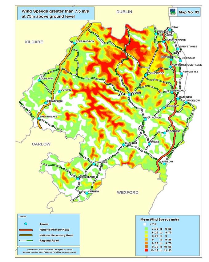
Wicklow County Development Plan 2010-2016                                     Volume 2 – Wind Strategy

Step 3 Evaluation of Areas of Wind Energy Potential

Following Steps 1 and 2, it is possible to derive a residual map, showing the locations where there are
no designations that would preclude wind farm development and where wind speeds would make
exploitation viable.
As these areas will not be uniform in their characteristics, the next step was to break these areas up
into ‘cells’ with similar characteristics and to evaluate each cell.
These areas were evaluated on the following grounds:-
     1. Landscape and visual sensitivity
     2. Impact on material assets
     3. Land cover issues
     4. Grid connection issues

Landscape and visual sensitivity

This topic has two separate but closely related aspects. The first aspect to be considered is visual
impacts, focusing on the extent to which new developments can be seen; the second aspect is the
perceived impact on the character of the landscape and examining responses, which are felt towards
the combined effects of the new development. This latter topic is complex because it encompasses
many other impacts such as noise, odours, ecology, history and because attempts to scientifically
measure feelings and perceptions are not reliable.

In evaluating each cell, consideration was given to
    – landscape classification as per the Wicklow County Development Plan;
    – designated tourism routes and listed views and prospects;
    – residences, tourism facilities and amenities;
    – sites and monuments of archaeological, architectural or historical interest;
    – the sensitivity and vulnerability of the area to landscape or visual change.

Map 3 to follow outlines the landscape categories of the County, in addition to listed views and
prospects, which it is an objective of the plan to protect from inappropriate development. The fact that
any area is located in a particular landscape zone or is subject to views or prospects would not in
itself render the area unsuitable to wind farms. However, where an area is particularly sensitive and
vulnerable in these regards, it must be considered less favourable to exploitation, and more difficult to
develop given the constraints that would be faced in the siting and design of any development.

Volume 2                                                                                 Wind Strategy

                                                                                                            4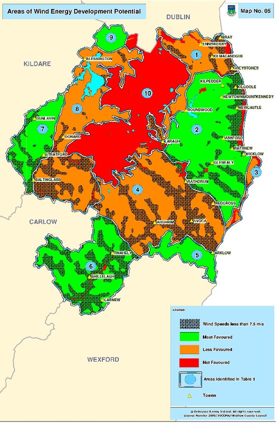
Wicklow County Development Plan 2010-2016             Volume 2 – Wind Strategy

                                            Wicklow CDP 2010 - 2016

Volume 2                                                       Wind Strategy

                                                                                 5
Wicklow County Development Plan 2010-2016 Volume 2 – Wind Strategy
Impact on material assets
Material assets are resources that are valued and intrinsic to specific places, they may be of either
human or natural origin and the value may arise for either economic or cultural reasons. The
assessment objectives vary considerably according to the type of assets, those for economic assets
being concerned primarily with ensuring equitable and sustainable use of resources. Assessments of
cultural assets are more typically concerned with securing the integrity and continuity of both the
asset and its necessary context.
Economic assets of natural value include assimilative capacity of air and water; non-renewable
resources (e.g. minerals, soils); renewable resources (hydraulic head, wind exposure); deep-water
berthage.
Economic assets of human origin include cities, towns, villages and settlements; transportation
infrastructure (roads, railways, airports etc); major utilities (water supplies, sewage, power systems
etc); ownership and access.
Cultural assets of a physical type include archaeology in context; architecture in
context; settlements; monuments, features and landmarks; historic sites and structures; geological
heritage.
Cultural assets of a social type include language and dialects; folklore and tradition; religion and
belief; literary and artistic association.
In these regards, the following were considered in each cell
- the location and scale of human settlement in that area;
- the density of items and places of heritage value, in particular protected
archaeological and architectural features;
- infrastructural assets, which it is an objective of the plan to protect.
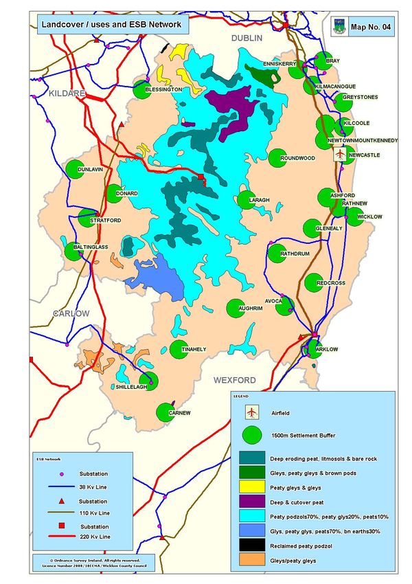
Land Cover issues
Certain locations may not be suitable for wind farm development due to existing land cover or land
uses. An obvious example would be the unsuitability of lands in towns or village centres. The land
cover / use types taken as being unsuitable for the purpose of this study are
- bog lands, due to the danger of land slides;
- lands within 600m of the historic core of a settlement or a residential zone within a
settlement;
- lands within 100m of the N11 / N81, in order to avoid driver distraction;
- lands within 1km of licensed airfields;
- lands within 100m of high voltage cables.
While forested lands are not included in this list, newly felled forestry land may present challenges
with regard to soil condition, land stability and drainage. Similarly, while tourism uses and wind energy
can happily co-exist, the effect of wind energy development on tourism and recreational activities
must be assessed. Wind energy developments are not incompatible with tourism and leisure
interests, but care needs to be taken to ensure that insensitively sited wind energy developments do
not impact negatively on tourism potential.
Grid issues
While new electrical transmission lines can be built to virtually any location, the benefit of connecting
a given site / location to the grid must be weighed up against the cost of such connections. The cost is
not only financial (which may impact on the viability of the site) but also environmental, with new
overhead power lines potentially disturbing habitats or migratory patterns.
In this regard, locations in excess of 10km from either the 110kV/220kV transmission lines or suitably
sized substations are less likely to be economically viable.
Map 4 to follow indicates land covers / uses and the electricity transmission network in County
Wicklow.
Volume 2 Wind Strategy
6Wicklow County Development Plan 2010-2016 Volume 2 – Wind Strategy
Wicklow CDP 2010 - 2016
Volume 2 Wind Strategy
7Wicklow County Development Plan 2010-2016 Volume 2 – Wind Strategy
Step 4 Results of assessment – County Wind Strategy (as outlined in Table 1 below)
Each cell has been assessed as set out above and the results are shown in the table and on map 5 to
follow. The County has been divided into three zones:-
Red Wind farm development will not be considered favourably in these areas
Not Favoured
Green Wind farm development will be considered favourably, subject to compliance with all
necessary siting and design standards
Most Favoured
Orange Wind farm development will be considered, but the sensitivities revealed in these
areas would render exploitation more problematic and therefore these areas are less
favoured for wind development
Less favoured
Table 1:
No Considerations Decision
1 Having regard to the high level of settlement this area (both in towns and in their rural Less
hinterlands), the proximity to areas of high amenity which includes the Great and Little favoured
Sugar Loafs and Bray Head, the close proximity to SACs, SPAs and the Wicklow
Mountains, the number of views / prospects and sites of architectural and archaeological
value in this area, is it considered that development of wind farms in this cell would be
particularly challenging
2 Having regard to the dispersed nature of settlement outside of the towns, reasonable Most
access to the grid and the limited number of views / prospects in the rural area, it is favoured
considered that this area is suitable for wind energy development. Applications in proximity
to the SACs (Vale of Clara, Carrigower Bog, and Deputy’s Pass) will be required to include
clear mitigation measures so as to eliminate or reduce the impact on these sites.
3 Having regard to the proximity to areas of high amenity value, the existence of views / Less
prospects along the coastline and the proximity of SACs (Buckroney-Brittas Dunes Fen and favoured
Magherabeg Dunes), this area is not considered generally suitable for wind energy
development; however there may be localised pockets that can be exploited.
4 While this cell is characterised by dispersed settlement outside of the towns and has Less
reasonable access to the grid, this is a scenic area, partially designated an Area of favoured
Outstanding Natural Beauty and is subject to numerous views / prospects. The tourist
destinations of Avoca and Aughrim are also in this cell. However, there are areas with good
wind resources, particularly south of Aughrim and around Redcross, that may be suitable,
with fewer visual and landscape sensitivities.
5 Having regard to the sparse settlement pattern, to good access to the grid and the limited Most
number of views / prospects in the area and taking into account the existence of an off- favoured
shore wind farm in visible proximity (which may alter the viewers ‘expectations’), it is
considered that this area is suitable for wind energy development.
6 Having regard to the small scale of the settlements in this area and dispersed nature of rural Most
development, reasonable access to the grid and the existence of wind farms, this area is favoured
considered highly suitable for wind energy developments.
7 Having regard to good access to the grid, the sparse settlement pattern and the limited Most
number of views / prospects, it is considered that this area is suitable for wind energy favoured
development.
8 Having regard to highly valued natural and built heritage in this cell, including the Less
Pollaphuca Reservoir area and the Baltinglass Hills, the proximity to the Wicklow Mountains favoured
SAC and the number of views and prospects, is it considered that development of wind
farms in this cell would be particularly challenging.
9 Having regard to good access to the grid, the sparse settlement pattern and the limited Most
number of views / prospects, it is considered that this area is suitable for wind energy favoured
development.
10 Having regard to the high amenity and heritage value of this area, in terms of views / Not
prospects, tourism / recreation and archeologically assets and given the EU protection favoured
afforded to the Wicklow Mountains SAC / SPA, this area is not considered suitable for wind
farm developments.
Volume 2 Wind Strategy
8Wicklow County Development Plan 2010-2016 Volume 2 – Wind Strategy
Wicklow CDP 2010 - 2016
Areas marked red – ‘Not Favoured’ outside of Cell 10 are designated Natura 2000 sites (formerly
SACs and SPAs) under the Habitats Directive. Proposed development at or in the vicinity of such
locations shall address the impact of the proposed development on the Natura 2000 site and
applicants will be required to demonstrate beyond all reasonable doubt that a proposed development
does not adversely impact on the integrity of the designated area.
Volume 2 Wind Strategy
9Wicklow County Development Plan 2010-2016 Volume 2 – Wind Strategy
3. Assessment criteria
Planning applications for wind energy developments will generally be assessed against the criteria set
out below and therefore all applications will be required to submit an evaluation of the project against
these criteria.
An application that is subject to an EIS will as a matter of course address all of these areas, but the
level of details required under each ‘heading’ can be determined and scoped with the Planning
Authority at pre-planning stage.
Those applications under the EIS threshold and not deemed by the Planning Authority to require an
EIS, will be required to be accompanied by an Environmental Report, addressing the issues of
relevance to the site (which should also be determined and scoped at pre-planning stage).
1. Potential impact of the project on natural heritage, to include direct and indirect effects on
- flora and fauna;
- protected sites;
- habitats of ecological sensitivity and biodiversity value
Where potential impacts are identified, mitigation measures, which may include management
plans to deal with the satisfactory co-existence of the wind energy development and the
particular species/habitat identified will be required.
2. Potential impact of the project on built heritage including
- archaeological sites;
- recorded monuments;
- protected sites / buildings;
This may include archaeological fieldwork in advance of the application being considered.
Buffer zones around such features will be required to be established, the normal zone normally
being a 200m radius around such features / sites.
3. Suitability of ground conditions, including soil and subsoil stability and presence of rock.
Particular attention will be paid to areas where peaty soils are prevalent or sites on steep
slopes, where soil slippages may be more likely. If this issue is identified as a concern, an
application for permission will be required to be accompanied by a report by a suitably qualified
and indemnified professional, verifying the stability of this area.
4. Site drainage and hydrological effects, such as
- impacts on ground water
- impacts on local water supplies
- impacts on surface water
- any requirements for watercourse crossings;
Particular detail will be required with regard to the construction phase of the development and
measures to be put in place to ensure no negative impacts result on hydrology and water networks.
This will include analysis of water flows on and across the site, identification of surface water system
sin the area, proposals for the management of excavated soil and construction materials (including
any oils or other chemicals) during construction.
Some sites may be required to put in place environmental monitoring of ground and surface water for
the duration of the operation of the installation.
5. As landscape issues and visual impacts are perceived as the key impact of wind turbines, a
detailed assessment of this impact will be required for all applications.
This assessment shall generally be carried out in accordance with best practice guidance available,
including that set out by the EPA in “Advice notes of current practice in the preparation of EIS” and by
the DoEHLG in “Wind Energy Development Guidelines for Planning Authorities”.
This assessment shall include an evaluation of the landscape and the ability of it to absorb wind
turbines. The cumulative impact of any application with any other such development or application in
the vicinity shall also be considered, along with any impacts associated with site works, site roads,
structures or new overhead transmission lines. All assessments shall include an analysis of the visual
impact of the development from views and prospects listed in the County Development Plan or any
Local Area / Town Plan.
Volume 2 Wind Strategy
10Wicklow County Development Plan 2010-2016 Volume 2 – Wind Strategy
Where impacts have been identified, mitigation measures will be required which may include
alterations to the layout, spacing, height and number of turbines.
Chapter 6 of the DoEHLG Guidelines provides direction on siting and design issues as they relate to
specific landscape character types. The issues addressed are location, spatial extent, spacing, layout
height and cumulative extent as set out below:
Cumulative
Location Spatial extent Effect Spacing Layout Height
Mountain Ridge and Large area Acceptable All spacing options Any layout may be Any height
peaks can depending on are usually acceptable but
acceptable in accommodate topography acceptable. Regular random or
certain wind as well as spacing is desirable clustered are
circumstances developments siting and preferred on
design ridges and hilltops
and grid on broad
sweeping areas
Hills & Flat Location on Generally Acceptable Regular Linear and Medium typically
Farmland ridges and limited in small subject to staggered linear preferred but tall
plateaux is scale appropriate layout on ridges may be acceptable
preferred siting and and clustered on on a high ridge
design hilltops
Transitional Ridges and Generally Generally not All options are open Linear and Small-scaled
Marginal hilltops small relative acceptable for consideration staggered linear areas, short
preferred to context and unless the layout on ridges turbines are more
do not bridge visual and clustered on preferable. Varied
two different presence of hilltops heights are
land covers the second acceptable in
e.g. moorland wind farm is undulating
and field areas negligible topography
Urban/industrial Close to but Relatively Minimal Regular spacing is Linear or Low enough to not
distinct from limited tolerance preferred. Graded staggered line is dominate existing
structures to spacing may be used preferred buildings. A few tall
ensure to aesthetic effect turbines may be
autonomy successful relative
to scale of existing
buildings
Coastal Zone Located on Depends on Minimal Regular spacing is Linear or Generally tall
solid ground, the shoreline. Tolerance. A preferred staggered linear especially close to
suited to low Wind energy second wind layout and parallel
beach development farm may be beaches
shorelines as should not acceptable
well as rocky extend beyond only at a very
promontories one particular great
shore line distance with
minimal
visual
presence
6. Local environmental and safety issues including
- noise;
- shadow flicker;
- interference with communications;
- aircraft safety
- proximity to power lines.
In evaluating potential noise impacts, regard shall be taken of the guidance set out Section 5.6 of the
Wind Energy Guidelines (DoEHLG 2006).
Conditions may require the monitoring of noise throughout the operational phase of the development.
In the event that the monitoring shows that any turbine is exceeding its projected noise levels and is
having a detrimental noise impact, mitigating measures shall be agreed with the Local Authority.
An assessment of the theoretical shadow flicker will be required for all dwellings within 600m of any
turbine. A further assessment shall indicate the likely level of shadow flicker based on anticipated
meteorological constraints. If required, mitigating measures shall be proposed.
Volume 2 Wind Strategy
11Wicklow County Development Plan 2010-2016 Volume 2 – Wind Strategy
As windturbines produce electromagnetic radiation, they may interfere with broadcast
communications. In this regard, all applicants should consult with national and local broadcasters prior
to the lodging of planning applications to determine the likelihood of any impacts and develop
mitigation measures.
As wind turbines may have implications for the operation of Air Traffic Control systems and flight
paths, regard shall be taken of the Irish Aviations Authority’s ‘Obstacles to Aircraft in Flight Order
(2002) as amended.
Adequate clearance between structures and overhead power lines as specified by the electricity
undertaker should be provided.
7. Adequacy of local access road network to facilitate construction of the project and
transportation of large machinery and turbine parts to site
Where it is evident that there may be difficulties in this regard, an outline of the likely
transportation route shall be submitted at application stage. However, it is acknowledged that
this is more of an operational issue that can normally be resolved through discussion and
agreement with the local area engineer and other safety bodies. Therefore, it would be more
normal for this to be agreed prior to the commencement of development.
Planning applications will include financial bonds for the repair or re-instatement of any public
roads that may be damaged as a result of the transportation of materials.
8. Adequacy of the proposed entrance to the site. Notwithstanding the fact that the construction
phase will have a limited duration, any application will need to provide a suitable entrance for
both the construction and operation phase of the development. In this regard, sightlines and
gradient will be required to meet applicable road safety standards.
9. The provision of water and effluent disposal facilities for construction and operation personnel.
4. Environmental Impact Assessment
An Environmental Impact Assessment is mandatory for wind energy developments that exceed the
following thresholds:
have more than five turbines, or
will have a total output greater than 5 megawatts.
In these circumstances, an Environmental Impact Statement must be submitted with the relevant
planning application (Section 176 of the Planning & Development Act 2000, and Article 93
and Schedule 5, of the Planning & Development Regulations, 2001).
Certain sub-threshold developments also require an Environmental Impact Assessment. The
information gathered during the Environmental Impact Assessment process should be used to guide
the planning and design of the wind energy development so that sensitive ecological or hydrological
areas are avoided, and any negative impacts are minimised insofar as is possible. Avoidance or
reduction of negative impacts on the environment and the consideration of alternatives are
fundamental components of Environmental Impact Assessment, both in terms of legal requirements
and best practice. In designing wind energy projects, there is huge potential to avoid or reduce
negative environmental impacts, owing to the small size of the actual development footprint.
Sub-threshold developments:
An Environmental Impact Assessment shall be carried out for wind energy developments below the
above mandatory limits if the Planning Authority (or An Bord Pleanála on appeal) considers that the
development would be likely to have significant effects on the environment, by reference to the
significant criteria in Annex III of the Environmental Impact Assessment Directive as transposed in
Schedule 7 of the Planning & Development Regulations, 2001. Regard should also be had to the
guidance contained in Environmental Impact Assessment (EIA) Guidance for Consent Authorities
regarding Sub-threshold Development, issued by the DoEHLG in August 2003.
Volume 2 Wind Strategy
12Wicklow County Development Plan 2010-2016 Volume 2 – Wind Strategy
5. Pre-planning
The primary purpose of consultation is to improve the quality of a subsequent application, to avoid the
necessity for seeking additional information and in some cases to spare the costs of what is likely to
prove an unsuccessful application.
Consultation can be of value in:
highlighting development plan objectives on wind energy;
suggesting need for specialist input.
To ensure that pre-application consultation is as productive as possible a developer shall be invited to
submit a minimum level of documentation in advance of the meeting, as follows:-
site location map
indication of the number of turbines proposed and their individual heights
sample zones of theoretical visibility
details of any known protected natural or built features on or surrounding the site
Good research and wide consultation by all parties at the site selection stage can avoid unnecessary
time delays and expense in considering unsuitable sites.
Volume 2 Wind Strategy
13You can also read