Coastal Zone Emergency Action Subplan - For the Nambucca Coastline - Item 9.5 Draft Coastal ...
←
→
Page content transcription
If your browser does not render page correctly, please read the page content below
Coastal Zone Emergency Action
Subplan

For the Nambucca Coastline

Draft Report
Nambucca Coastal Zone Emergency Action Subplan

Disclaimer:

Nambucca Valley Council has prepared this document with financial assistance from the NSW Government
through the Department of Planning, Industry and Environment (DPIE). This document does not necessarily
represent the opinions of the NSW Government or DPIE.

This report has been prepared by Hydrosphere Consulting on behalf of and for the exclusive use of
Nambucca Valley Council and is subject to and issued in accordance with the agreement between
Nambucca Valley Council and Hydrosphere Consulting. Hydrosphere Consulting accepts no liability or
responsibility whatsoever for it in respect of any use of or reliance upon this report by any third party.

Copying this report without the permission of Nambucca Valley Council or Hydrosphere Consulting is not
permitted.

Hydrosphere Consulting Pty Ltd
Suite 6, 26-54 River Street
PO Box 7059, BALLINA NSW 2478
www.hydrosphere.com.au

© Copyright 2020 Hydrosphere Consulting

18-019 COASTAL ZONE EMERGENCY ACTION SUBPLAN FOR THE NAMBUCCA COASTLINE
 REV    DESCRIPTION                   AUTHORS           REVIEW                   APPROVAL          DATE

 0      Draft for Client Review       K. Menzies        R. Campbell, K. Pratt    M. Howland        8 Dec 2020
Nambucca Coastline Emergency Action Subplan

CONTENTS
1.             INTRODUCTION ...................................................................................................................... 1

     1.1       Purpose .................................................................................................................................... 1

     1.2       Objectives and scope ............................................................................................................... 1

     1.3       Consultation.............................................................................................................................. 3

2.             AREAS AT RISK ...................................................................................................................... 4

     2.1       Beach erosion .......................................................................................................................... 4

     2.2       Coastal inundation .................................................................................................................... 4

     2.3       Landslip .................................................................................................................................... 5

3.             AGENCY ROLES AND RESPONSIBILITIES .......................................................................... 6

4.             COMMUNICATION BEFORE, DURING AND AFTER AN EMERGENCY EVENT ................. 9

5.             TRIGGERS FOR EMERGENCY ACTION ............................................................................. 10

6.             EMERGENCY RESPONSE ACTION PLAN .......................................................................... 11

     6.1       Prevention, Preparation, Response and Recovery Actions ................................................... 11

     6.2       Area specific response actions............................................................................................... 14

       6.2.1       Valla Beach ........................................................................................................................ 14

       6.2.2       Nambucca Heads .............................................................................................................. 14

       6.2.3       Scotts Head ....................................................................................................................... 15

       6.2.4       Priority for accessway repair and reopening ..................................................................... 16

     6.3       Emergency coordination centres ............................................................................................ 16

     6.4       Recording coastal emergency impacts and response actions ............................................... 16

GLOSSARY AND ABBREVIATIONS .................................................................................................... 17

REFERENCES AND FURTHER READING .......................................................................................... 18

APPENDIX 1.               MAPS ......................................................................................................................... 19

FIGURES
Figure 1: Legislative context .................................................................................................................... 2

Figure 2: Coastal management emergency response phases ................................................................ 3

Figure 3: Hazard zones - Valla Beach ................................................................................................... 20

Figure 4: Hazards Zones – Nambucca Heads (South) ......................................................................... 21

Figure 5: Hazard zones - Nambucca Heads (North) ............................................................................. 22

Figure 6: Hazard zones - Scotts Head .................................................................................................. 23

Figure 10: Sites of slope instability ........................................................................................................ 27

                                                                                                                                                             Page ii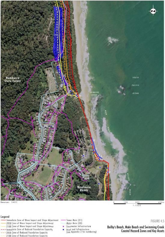
Nambucca Coastal Zone Emergency Action Subplan

TABLES
Table 1: Key sites and assets potentially at risk due to beach erosion ......................................... 4

Table 2: Sites with potential inundation risk .................................................................................. 4

Table 3: Keys sites presenting geotechnical hazards ................................................................... 5

Table 4: Roles and responsibilities ................................................................................................ 6

Table 5: Coastal Emergency Actions Phase 1 - Prevention ....................................................... 11

Table 6: Coastal Emergency Actions Phase 2 - Preparation ...................................................... 11

Table 7: Coastal Emergency Actions Phase 3 - Response ........................................................ 12

Table 8: Coastal Emergency Actions Phase 4 - Recovery ......................................................... 13

Table 9: Emergency response actions for Valla Beach .............................................................. 14

Table 10: Emergency response actions for Nambucca Heads ................................................... 15

Table 11: Emergency response actions for Scotts Head ............................................................ 15

Table 12: Alternative emergency response coordination centres ............................................... 16

Table 13: Valla Beach asset register ........................................................................................... 24

Table 14: Nambucca Heads asset register ................................................................................. 25

Table 15: Scotts Head asset register .......................................................................................... 26

                                                                                                                                         Page iii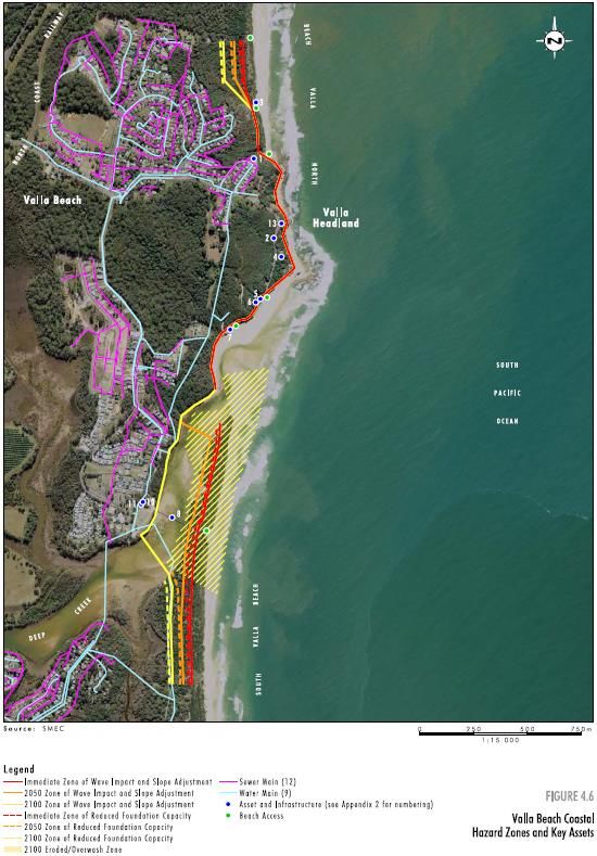
Nambucca Coastal Zone Emergency Action Subplan

1.        INTRODUCTION
This Coastal Zone Emergency Action Subplan (CZEAS) forms part of the Nambucca Coastal Management
Program (CMP) (Hydrosphere Consulting, 2020). This CZEAS applies to the beaches and coastal
communities within the Nambucca Valley Council Local Government Area.

1.1       Purpose
This CZEAS details arrangements for the four emergency phases (prevention, preparation, response and
recovery) to manage coastal emergency events relating to coastal erosion, cliff instability and coastal
inundation. The purpose of this subplan is to provide emergency response actions in order to:

     •   Protect human life and public safety.

     •   Minimise damage to property and assets.

     •   Minimise impacts on social environmental and economic values.

     •   Not create additional hazards or risks.

1.2       Objectives and scope
Although the Coastal Vulnerability Area is not mapped in the Coastal Management SEPP 2018 (CM SEPP),
the Nambucca coastline is subject to the coastal hazards of beach erosion, coastal inundation and cliff
instability which have been addressed in the CMP through the following actions:

     •   Coastal hazard planning and development controls.

     •   Coastal hazard monitoring program.

     •   Ongoing maintenance and/or upgrade of existing coastal protection infrastructure.

     •   Periodic beach scraping works as needed to assist beach recovery after erosion events.

     •   Dune management.

This CZEAS is consistent with the objects of the Coastal Management Act 2016 (CM Act section 3) and the
relevant management objectives for the coastal vulnerability area (section 7 of the CM Act) specifically to
prioritise actions that support the continued functionality of essential infrastructure during and immediately
after a coastal hazard emergency and to improve the resilience of coastal development and communities by
improving adaptive capacity and reducing reliance on emergency responses.

The CZEAS is also consistent with the emergency management provisions addressed in the state, regional
and local emergency management plan (EMPLANs) and state and local flood plans (Figure 1).

                                                                                                        Page 1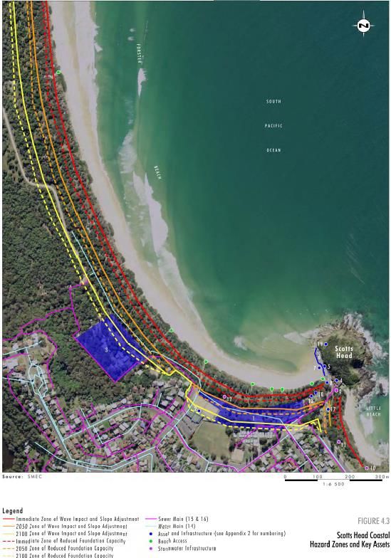
Nambucca Coastline Emergency Action Subplan

          State Emergency
                                                                                  Coastal
            and Rescue
                                                                               Management Act
          Management Act
                                                                                   2016
                1989

             NSW State
              EMPLAN

                                            NSW State Flood
                                                 Plan

                                                                                  Nambucca
           North Coast
                                                                                Coastline and
         Regional EMPLAN
                                                                                Estuaries CMP

          Nambucca Shire
          Council EMPLAN

                                                                                 CZEAS for the
                                            Nambucca Shire                         Nambucca
                                            Local Flood Plan                        Coastline
                                                                                (this document)

Figure 1: Legislative context

This CZEAS details:

   •   The triggers which define when a ‘coastal emergency’ is occurring (Section 5).

   •   Areas at risk during coastal emergencies (Section 2).

   •   Agency roles and responsibilities during coastal emergencies (Section 3).

   •   Communications required before during and after an emergency (Section 4) to inform the public and
       potentially affected property owners about their responsibilities during a coastal emergency and what
       actions they are and are not permitted to undertake.

   •   The actions required to mitigate, prepare for, respond to and recover from coastal emergencies
       (Section 6).

   •   Identifies the potential location and types of works that may be undertaken for the protection of
       property and assets (Section 6.2).

Actions to be implemented in the four phases of emergency management (Figure 2) are included in this
CZEAS.

                                                                                                       Page 2
Nambucca Coastal Zone Emergency Action Subplan

Figure 2: Coastal management emergency response phases
Source: DPIE (2019)

The actions detailed in this subplan depend on resource availability at the time of the emergency. If local
agencies and available resources are insufficient to cope with the emergency, they will be supported by
those at district level and if necessary, the state level.

1.3         Consultation
Public authorities involved in the implementation of this CZEAS will be provided a copy of the draft CZEAS
for review and comment. The final CZEAS will address any feedback received.

                                                                                                        Page 3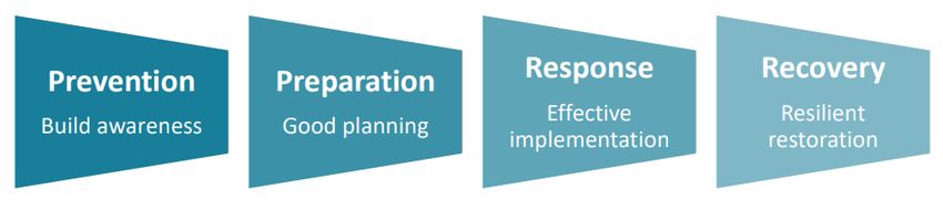
Nambucca Coastline Emergency Action Subplan
2. AREAS AT RISK
Coastal hazard vulnerability has been mapped by SMEC (2009) for coastline areas and infrastructure at risk.
The Coastal Zone Management Plan (Umwelt, 2012) developed a register and maps of assets at risk based
on this mapping (Appendix 1).
2.1 Beach erosion
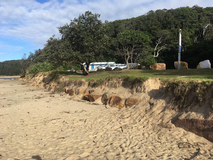
Erosion of the sandy shoreline has been occurring in the central and southern areas of Nambucca Valley
LGA resulting in undermining and collapse of some beach access points, inaccessibility to and from the
beach and amenities (e.g. surf club, car park), public safety risks presented by a steep scarp face, loss of
long established dune vegetation and loss of amenity. A list of key sites to be monitored during storm events
(Table 1) has been developed based on hazard mapping (SMEC, 2009) and the asset registers (Umwelt,
2012).
Table 1: Key sites and assets potentially at risk due to beach erosion
Area Site Assets to monitor
South Valla Beach Beach accessways, car park, amenities
Valla Beach
North Valla Beach Beach accessway, 4WD beach access point
Amenities, beach access ramps, boat ramps, fish cleaning facilities, car
Shelley Beach
park, picnic facilities, picnic area, accessways
Nambucca Beilbys Beach Beach access ramp, car park, Beilbys beach road, accessways
Heads Main Beach roadway, beach access ramp, boat ramp, car park, picnic area,
Main Beach
seawall, surf club, beach accessways, stormwater infrastructure
Swimming Creek Beach access, 4WD access, Swimming Creek erosion controls
Frontal dune at Beach accessways
Forster Beach
Scotts Head
South-east end of Seawall in front of car park, boat ramp, stormwater drain at beach access
Forster Beach
2.2 Coastal inundation
Sites outlined by SMEC (2009) and the asset registers (Umwelt, 2012) with potential risk of inundation by
waves during a storm event are detailed in Table 2.
Table 2: Sites with potential inundation risk
Area Site Potential inundation Risk Sites
South Valla Carpark, picnic area and toilet block near Deep Creek entrance
Valla Beach
Beach
Page 4Nambucca Coastal Zone Emergency Action Subplan
Area Site Potential inundation Risk Sites
Main Beach Nambucca Heads Main Beach Surf Lifesaving Club
Waves could potentially overtop the main breakwater east of the V-wall (between the
V-wall and Wellington Rocks) resulting in a hazard to pedestrians at the walkway
Nambucca behind the breakwall
Heads V-wall Low-lying sections of Riverside Drive
White Albatross Holiday Park and carpark at potentially at risk of flooding
Low-lying sections of Wellington Drive
South-east end Scotts Head Surf Lifesaving Club and adjacent carpark
Scotts Head
of Forster beach
2.3 Landslip
The rocky headlands and bluffs experience rock falls and undercutting by wave action which present a public
safety risk and a low risk to property and infrastructure. Key sites were identified in the Nambucca Valley
Council Coastal Slope Instability Hazard Study (SMEC, 2011) which are presented in Table 3 along with an
additional site (cliff behind White Albatross Holiday Park) with a history of subsidence and/or instability which
was identified in the CMP. These key landslip risk sites will be key monitoring points during extreme weather
(refer Appendix 1).
Table 3: Keys sites presenting geotechnical hazards
Area Site Key Landslip Risk Sites Hazard zone (SMEC,
2011)
Valla Beach North Valla Southern Headland Hazard Zone vbA
Beach
Sea cliffs south of North Valla Beach Hazard Zone vbB
Wellington Drive Hazard Zone nhT
Cliff behind White Albatross Holiday Park NA
Nambucca River
Nambucca Road cuttings and scarp upslope of Riverside Drive Hazard Zone nhI
Heads Downslope fill batter of Riverside Drive Hazard Zone nhH
Main Beach Car Park at Main Beach Hazard Zone nhAM
Western side of access road to Main Beach Hazard Zone nhAN
Scotts Head Forster Beach Cutting behind SLSC Hazard Zone shI
Western end of Little Beach (adjacent to Elephant Hazard Zone shD
Little Beach Head)
Corner of Mathew and Vernon Streets Hazard Zone shF
Page 5Nambucca Coastline Emergency Action Subplan
3. AGENCY ROLES AND RESPONSIBILITIES
Personnel and agencies with roles and responsibilities under this CZEAS are listed in Table 4.
Table 4: Roles and responsibilities
Agency Responsibility
Nambucca Valley • Carrying out (or authorising and coordinating) of emergency coastal protection works
Council (NVC) to protect public assets from coastal erosion and inundation.
• Closing unsafe beach accessways.
• Combat agency for coastal erosion emergencies caused by severe weather or storm
activity. During coastal erosion from ocean storms, responsibilities include:
o Assist NSW State Emergency Services (SES) with reconnaissance of coastal
erosion risk areas.
o Liaise with the NSW SES Local Controller to provide advice regarding the
need for response actions by the NSW SES such as evacuations.
o Activate this plan.
• To assist, at their request, the Police, SES, and the Local Emergency Operations
Controller (LEOCON) in dealing with a coastal emergency.
• Provide engineering resources required for response and recovery.
• For coastal erosion that is not caused by storm activity yet requires emergency
management, NVC would provide a range of support to the LEOCON who are the
agency responsible for emergency management.
• Maintaining and updating the CZEAS as necessary.
• Provide information on the status of roads and beach accessways.
• Provide back-up radio communications.
• In the event of evacuations, assist with making facilities available for the domestic pets
and companion animals of evacuees.
NVC Local Emergency • Monitor emergency operations.
Operations Controller • Controlling and coordinating the emergency management of coastal erosion that is not
(LEOCON) caused by storm activity, as per action 1.4.3 of the NSW State Storm Plan (State
Emergency Management Committee, 2018a).
• When requested by a combat agency, to co-ordinate the provision of resources
support. LEOCON may assume control from the combat agency if the situation can no
longer be contained. Where necessary, this should only be done after consultation with
the Regional Emergency Operations Controller (REOCON) and agreement of the
combat agency and with the appropriate level of control (NSC, 2016).
NVC Local Emergency • Provide support to the Local Emergency Management Committee (LEMC) and
Management Officer LEOCON in accordance with the Nambucca EMPLAN (NSC, 2016).
(LEMO)
Page 6Nambucca Coastal Zone Emergency Action Subplan
Agency Responsibility
NSW State Emergency • Acts as the Combat Agency for damage control and the coordination of community
Services (NSW SES) evacuation during the following coastal zone hazards as per the Nambucca EMPLAN
Nambucca Shire Unit (Nambucca Shire Council, 2016):
Members o Flooding
o Storms
o Tsunamis
• Carry out required response tasks. These may include:
o Assist in the collection of flood and coastal erosion/inundation information for
the development of intelligence
o Evacuation
o Delivery of warnings
o Assisting with road closures and traffic control operations
• Not authorised to undertake coastal protection works (such as placement of rocks or
geotextile sand containers).
NSW SES Local • Dealing with floods as per the Nambucca Shire Local Flood Plan (NSW SES, 2013).
Controller • Identify and monitor people and/or communities at risk of flooding and coastal erosion.
• Provide an information service in relation to:
o Coastal erosion
o Coastal inundation
o Road conditions and closures
o Confirmation of evacuation warnings and evacuation orders
• Direct the evacuation of people and/or communities.
• Ensure caravan parks are advised of flood/ coastal inundation warnings.
• Coordinate the collection of flood and coastal erosion/inundation information for
development of intelligence.
The Ambulance • Assist with the evacuation of at-risk people (i.e. elderly, frail, disabled, sick)
Service of NSW
Australian Government • Provide severe weather warnings, preliminary flood warning, flood warning, flood
Bureau of Meteorology watch, severe thunderstorm warning or a warning for severe ocean conditions or flash
(BoM) flooding warnings for the Nambucca Shire.
Marine Rescue NSW • Assist the NSW SES with:
o Evacuation warnings and evacuation orders.
o The conduct of evacuations.
o Resupply operations.
Page 7Nambucca Coastline Emergency Action Subplan
Agency Responsibility
NSW Police Force • Responsible as the combat agency for landslip occurrences.
• When requested by NSW SES, required to assist in flood operations (where suitable
trained and suitable equipment is available) including assistance with:
o The warning and/or evacuation of at-risk communities.
o Flood rescue operations.
o Monitoring / reconnaissance of flood prone areas.
o Resupply of isolated communities and/or properties.
o Property protection tasks including sandbagging.
• Conduct road and traffic control operations in conjunction with council.
• Coordinate the registration of evacuees.
• Secure evacuated areas.
Surf Life Saving NSW • Assist the NSW SES with the warning and/or evacuation of at-risk communities;
Nambucca River When requested by NSW SES, required to assist in flood operations (where suitably
Marine Rescue Squad - trained and suitable equipment is available) including assistance with:
Volunteer Rescue o The warning and/or evacuation of at-risk communities.
Association (VRA)
o Flood rescue operations.
o Monitoring / reconnaissance of flood prone areas.
o Resupply of isolated communities and/or properties.
o Property protection tasks including sandbagging.
Fire and Rescue NSW • When requested, and when FRNSW training and equipment is suitable, assist combat
(FRNSW) agencies with response and recovery operations.
• During floods and storms, provide assistance to the NSW SES in accordance with the
Memorandum of Understanding between FRNSW and SES.
Local Emergency • Council advisory committee including representatives from the above agencies.
Management
Committee (LEMC)
Page 8Nambucca Coastal Zone Emergency Action Subplan
4. COMMUNICATION BEFORE, DURING AND AFTER AN EMERGENCY
EVENT
NVC will provide information about anticipated coastal emergency events to residents near the hazard zones
and community representatives from the SLSCs, holiday park and nearby businesses through the following
mechanisms:
• Provide routine emergency management briefings to communicate the strategy outlined in this plan
including coastal emergency triggers, areas at risk, roles and responsibilities and response action
plan.
• Provide emergency management information (in the form of signage and brochures) at local
community centres.
• In consultation with the SES and BoM, provide information about approaching coastal emergencies
on its website.
• Coordinate with the SES to ensure residents are aware of urgent hazards during emergency events,
and provide assistance with door-to-door communication as necessary.
• Place barriers and sign at beach accessways that are closed due to coastal erosion impacts.
• Provide up to date information on Council’s website regarding beach accessway closures and re-
openings.
Page 9Nambucca Coastline Emergency Action Subplan
5. TRIGGERS FOR EMERGE NCY ACTION
The following events and triggers will activate the Response Phase:
• Storm bite is eroding or expected to erode key sites and assets identified in Table 1.
• Waves are threatening to overtop the key inundation risk sites identified in Table 2.
• When a severe weather warning, preliminary flood warning, flood warning, flood watch, severe
thunderstorm warning or a warning for severe ocean conditions or flash flooding is issued by the
BoM.
• Signs of cliff instability during severe weather or strong waves (refer below).
• Evidence leads to an expectation of flooding, coastal erosion or landslip within 24 hours in the NVC
LGA considering the predicted wave height and tidal range and the condition of the beach and
accessways.
Signs of cliff instability caused by severe weather include:
• Open cracks or steps along contours.
• Bulging in the lower part of the slope.
• Trees leaning down slope or with exposed roots.
• Debris/fallen rocks at the foot of a cliff.
• Tilted power poles or fences.
• Cracked or distorted structures.
Consideration should be given to the following factors which may contribute to cliff failure/ landslips (SMEC,
2011):
• Undercutting of slopes by sea storms.
• Wave action removing fallen debris.
• Periodic wetting of slope material by waves and mist leading to frequent repeated cycles of wet/dry
conditions as well as variations in temperature of slope material.
• Prolonged rainfall with water percolating into rock mass defects causing washout of fines and
reduction of rock mass strength.
• High winds which remove sand, aiding the infiltration of salt spray into defects.
• Earthquakes.
Once this Response Phase is triggered, Council will activate this plan and follow the actions detailed in
Section 6.
Page 10Nambucca Coastal Zone Emergency Action Subplan
6. EMERGENCY RESPONSE ACTION PLAN
6.1 Prevention, Preparation, Response and Recovery Actions
Council’s ability to undertake the actions identified in this subplan will be dependent on the availability of
resources during emergency events. Actions must not conflict with or impede SES or DPIE actions. Actions
must not put personnel staff or volunteers in danger. Emergency protection works must not be undertaken
during extreme weather unless tide variations permit works to be undertaken safely.
Table 5: Coastal Emergency Actions Phase 1 - Prevention
Action ID Timing Action
1.1 Planning Within 6 months of Through the Local Emergency Management Committee (LEMC), consult
EMPLAN updates with SES, DPIE, Local Police, LEOCON, FRNSW to ensure the Local
Emergency Management Plan and evacuation procedures are consistent
with this CZEAS.
1.2 Update Within 3 months of Review and update this CZEAS with any updates from the Coastal
Coastal Hazard Hazard Monitoring Program undertaken as part of the CMP
Monitoring implementation.
Program outcomes
1.3 Consultation Ongoing Provide advice to the community, landholders and the NSW SES about
the potential for a coastal emergency from beach erosion, coastal
inundation or cliff instability and the types of responses that are and are
not permitted.
1.4 Consultation Ongoing Provide updates to the wider community as necessary via Councils
website, through information sessions.
Table 6: Coastal Emergency Actions Phase 2 - Preparation
Action ID Timing Action
2.1 Update Every 6 Ensure emergency contact information is available for staff and the community and
months details are up to date.
2.2 Planning Within 6 Develop coastal monitoring proforma to track coastal change over time as well as
months establish monitoring locations for when this plan is activated.
2.3 Consultation Within 6 Hold an information session for council staff outlining emergency responses within
months this plan and ensuring relevant personnel have the copies of the plan.
2.4 Planning Within 12 Determine procedures and obtain approvals necessary to access sites to potentially
months place and remove geotextile sand containers or other appropriate measures (refer
section 6.2) and undertake beach scraping at Scotts Head.
2.5 Planning Within 12 Ensure geotextile sand containers, signage to close beach accessways and signage
months warning pedestrians of coastal inundation are available for use during coastal
emergencies.
2.6 Planning Ongoing Ensure appropriate plant, equipment and experienced personnel are available for
protection of assets at risk.
Page 11Nambucca Coastline Emergency Action Subplan
Action ID Timing Action
2.7 Monitoring Ongoing Regular monitoring of coastal conditions, tide, wave height and weather condition
forecasts for indication of approaching coastal hazards (triggers for emergency
action).
Coastal emergency response actions which apply to the whole Nambucca coastline are outlined in Table 7.
Specific response actions for Valla Beach, Nambucca Heads and Scotts Beach are detailed in Section 6.2
including details of potential emergency coastal protection works.
Table 7: Coastal Emergency Actions Phase 3 - Response
Action ID Timing Response action
3.1 Communication Response Phase activated In conjunction with SES, advise landholders, residents,
SLSCs, public authorities and other organisations that
a coastal emergency is occurring.
3.2 Monitoring Response Phase activated Monitor events and triggers that will activate the
Response Phase.
3.3 Preparation Response Phase activated Place appropriate equipment on standby (back up
radios, geotextile sand containers, signs and
barricades etc.).
3.4 Monitoring Response Phase activated Investigate any unauthorised coastal works and
monitor as necessary.
3.5 Closure Signs of cliff instability recognised Close access to potentially affected sites.
during monitoring Seek professional coastal or geotechnical engineering
advice where major infrastructure is believed to be at
threat. Advice should also be sought from DPIE, local
Police and SES where appropriate.
3.6 Closure Waves cause or likely to cause Close off access to potentially affected sites, erect
inundation of areas with public barricades and signs.
access
3.7 Closure Beach access is unsafe due to: Close off access to potentially affected sites and/or
• Broken or protruding steps, erect barricades and signs.
slats, platforms, posts, metal
post, chains, wires, concrete
or rubble.
• A sudden drop off greater
than 0.5 m.
• Dangerous waves or
excessive wave runup.
• Otherwise deemed unsafe.
3.8 Closure Upon coastal inundation, erosion Close roads and affected areas and erect barricades
impact or cliff instability affecting and signs as necessary.
roads.
Page 12Nambucca Coastal Zone Emergency Action Subplan
Action ID Timing Response action
3.9 Closure As required Shutdown water and sewer infrastructure affected by
beach erosion, coastal inundation or cliff instability
hazards.
3.10 Assistance As required Support SES actions.
3.11 Respond As required - only if safe to do so. Install geotextile sand containers or other appropriate
measures to address beach erosion, coastal inundation
or cliff instability if safe to do so. Refer Section 6.2 for
sites which may require response actions.
3.12 Communication Response Phase activated Release media information as necessary to keep
community informed.
Table 8: Coastal Emergency Actions Phase 4 - Recovery
Action ID Timing Response action
4.1 Inspection Conduct/ organise detailed inspections of sites potentially
affected by beach erosion and coastal inundation and assess
damage to assets and the natural environment.
4.2 Inspection Conduct detailed inspection of sites at risk of landslip for signs
of cliff instability. Assess the structural integrity of any damaged
infrastructure. Seek professional geotechnical advice as
required.
4.3 Restoration Where beach erosion has caused a large escarpment/ drop off
(>0.5 m) at frontal dunes, pedestrian accessways beaches or
within 1.5 m of built assets (car parks, SLSC, roadways,
pedestrian paths) Council will remediate the area to restore
safe beach access (refer Section 6.2).
4.4 Restoration Following a coastal Arrange for permanent repair of damaged assets or the
emergency, or as rehabilitation of the environment. Maintain emergency
necessary protection works until permanent repair can be undertaken.
4.5 Communication Continue communication protocols as necessary.
4.6 Restoration Remove or manage beach debris prioritising the most visited
beaches.
4.7 Inspection Assess the structural integrity of any damaged infrastructure.
Seek professional advice as required.
4.8 Restoration Remediate/ replace any damaged infrastructure.
4.9 Restoration Rehabilitate damaged dune systems coordinating with
Landcare/ Dunecare groups.
4.10 Monitoring Monitor beach response to beach scraping and renourishment.
4.11 Preparation Replenish emergency response supplies.
4.12 Record Record coastal emergency impacts and response actions
(Section 6.4).
Page 13Nambucca Coastline Emergency Action Subplan
Action ID Timing Response action
4.13 Review Within 6 months Critically review this CZEAS and update as necessary to
following plan improve the effectiveness of coastal emergency response
activation or as actions.
necessary.
6.2 Area specific response actions
6.2.1 Valla Beach
Vehicle access to Valla Beach following a coastal emergency is as follows:
• South Valla Beach – No formal access. Informal access via the carpark (between the amenities
block and the fence) if necessary.
• North Valla Beach – at the 4WD access point (accessed via Cockburn Street).
Table 9: Emergency response actions for Valla Beach
Area Action Response Actions
ID
Monitor the performance of the seawall at South Valla Beach following a storm event. Repair
V3.1
and maintain if necessary.
Use geotextile sand containers or other appropriate measures to prevent further erosion at
South
South Valla Beach amenities and carpark area if:
Valla
• The amenities block and carpark are deemed to be at risk;
Beach V3.2
• subsequent storms are forecast which would likely cause further erosion; or
• the mouth of Deep Creek migrates north and threatens the carpark and amenities
block.
North Assess the cliff stability at Valla Headland following a storm to ensure the car parks and
Valla accessways are safe and stable. Seek professional geotechnical advice if the cliff presents any
Beach V3.3 signs of cliff instability. Place geotextile sand containers or other stabilisation works at the
pedestrian beach accessway if it is being impacted by erosion and subsequent storms are
forecast.
Inspect the footbridge following severe storms and/or heavy rainfall to ensure the footings are
V3.4
secure and the bridge is safe to use.
V3.5 Close the 4WD beach accessway at North Valla Beach as necessary.
6.2.2 Nambucca Heads
Vehicle access to the beaches to undertake recovery actions is as follows:
• Shelley Beach – access via the boat ramp.
• Main beach – access via the boat launch near the SLSC.
• Beilbys Beach – via Shelley Beach access.
• Swimming Creek Beach – via the 4WD access (adjacent to Swimming Creek entrance).
Page 14Nambucca Coastal Zone Emergency Action Subplan
Table 10: Emergency response actions for Nambucca Heads
Area Action Response Actions
ID
Shelleys N3.1 Geotextile sand containers or other suitable measures may be used to temporarily protect
Beach assets at risk of being damaged due to landslips or erosion or to reinforce existing rock
revetment if scour is occurring. Monitor the seawall at the carpark and amenities block.
Maintain and repair as necessary.
Beilbys N3.2 Geotextile sand containers or other suitable measures may be used to protect the dunes
Beach and/or beach accessways if subsequent severe weather is forecast which may impact the
dunes.
Main Beach N3.3 Monitor the performance and condition of seawalls at the SLSC and car park. Maintain and
repair as necessary. Geotextile sand containers may be used as necessary to protect beach
access ramp, boat ramp, car park, picnic area, seawall, surf club, beach accessways,
stormwater infrastructure.
Swimming N3.4 Monitor Swimming Creek erosion controls. Maintain and repair as necessary.
Creek
V-wall N3.5 Close pedestrian access and erect warning signs as necessary. Alert owners and residents
of White Albatross caravan park if the area is at risk of coastal inundation.
Nambucca N3.6 Monitor riverside Dr and Wellington drive for coastal inundation. Close and/or erect warning
River signs as necessary.
6.2.3 Scotts Head
Access to the beach to undertake emergency recovery activities is at the boat ramp at the south of Forster
Beach. If access via the boat ramp is not possible there is a 4WD accessway further north along Forster
Beach (near the sewage treatment plant).
Table 11: Emergency response actions for Scotts Head
Area Action Response Actions
ID
South S4.1 Where beach erosion has caused a large escarpment/ drop off at the frontal dunes and/ or at
Forster pedestrian accessways to Forster Beach, Council will undertake beach scraping to move
Beach sand back from the beach face to the frontal dune and to place sand at any eroded
accessways to restore safe beach access.
S4.3 Geotextile sand containers or other suitable measures may be used to temporarily protect the
seawall in front of the car park, the boat ramp, stormwater infrastructure and beach
accessways at risk of being damaged due to landslips or erosion.
North S4.4 Geotextile sand containers or other suitable measures may be used to protect the dunes
Forster and/or beach accessways if subsequent severe weather is forecast which may impact the
Beach dunes.
Page 15Nambucca Coastline Emergency Action Subplan
6.2.4 Priority for accessway repair and reopening
When multiple accessways are damaged, Council will give priority to restoration of access in the following
locations:
1. Beach access at SLSC.
2. Beach accessways from public reserves with car parking and other beach user facilities.
3. Beach accessways that are critical to along shore public access such as community walking or
cycling paths.
4. Other accessways.
6.3 Emergency coordination centres
The key coordination centre will be the Council Administration Centre. Alternative centres outlined in Table
12 may be also be used as required.
Table 12: Alternative emergency response coordination centres
Beach Emergency coordination centre
Valla Beach Scotts Head SLSC or Holiday Park
Nambucca Heads Nambucca Heads SLSC or RSL
Scotts Head Community Hall (Valla Beach Road)
6.4 Recording coastal emergency impacts and response actions
After a coastal emergency, Council will record the following details in order to maintain effective emergency
response actions and understand any changes in coastal conditions over time:
• Details of any erosion, coastal inundation, landslips or cliff instability and the weather conditions
under which they were caused, including photographs, location of assets and infrastructure that were
damaged and details of the extent of the damage.
• Details of any emergency protection works undertaken including the cost and the installation date.
• Review and update (if required) the emergency response action plan in consultation with the SES
and any other relevant agencies.
Page 16Nambucca Coastal Zone Emergency Action Subplan
GLOSSARY AND ABBREVIATIONS
Term Definition
Beach erosion Landward movement of the shoreline and/or a reduction in beach volume, usually
associated with storm events or a series of events, which occurs within the beach
fluctuation zone (Office of Environment and Heritage, 2018).
Beach scraping Also referred to as ‘nature assisted beach enhancement’ (NABE) is a mechanical
intervention to speed up the natural processes of berm and foredune recovery after a
storm event (Office of Environment and Heritage, 2018).
BoM The Bureau of Meteorology
Cliff instability Refers to geotechnical instabilities on coastal cliffs and bluffs, including rock falls, slumps
and landslides.
Coastal emergency An emergency due to actual or imminent coastal inundation, coastal erosion or cliff
instability which (a) threatens endangers, or threatens to endanger, the safety or health of
persons; or (b) destroys or damages, or threatens to destroy or damage, any property or
the natural environment.
Coastal inundation When land that is usually ‘dry’ to become inundated by sea water.
Combat Agency The agency identified in the DISPLAN or in this subplan as the agency primarily
responsible for controlling the response to a particular emergency. (SERM Act 1989).
CZEASP Coastal Zone Emergency Action Subplan (this document)
DISPLAN Local Disaster Plan.
Emergency coastal Emergency coastal protection works may comprise the placement of sand, or the placing
protection works of geotextile sand containers prior to or during an emergency for a period of not more
than 90 days.
Geotextile sand Containers manufactured from water permeable, sand-tight geotextile (either woven, non-
containers woven, or composite). Containers are available in a variety of sizes and shapes from
small sand bags (hand-filled) to large containers requiring mechanical filling and
placement.
Nambucca Valley The committee constituted under the State Emergency and Rescue Management Act
Council Local Emergency 1989 for the local government area, responsible for the preparation of the local EMPLAN
Management Committee and local flood plan.
(LEMC)
Local Emergency A Police Officer appointed by the District Emergency Operations Controller as the Local
Operations Controller Emergency Operations Controller for the Local Government Area.
(LEOCON)
Nambucca EMPLAN Nambucca Local Emergency Management Plan
SERM Act State Emergency and Rescue Management Act 1989
Site Controller A police officer appointed by and subject to the direction of the local emergency
operations controller (LEOCON) to be responsible for determining the site, establishing
site control and controlling on the ground response to an emergency. Until the LEOCON
appoints a Site Controller, the Senior Police Officer will assume control.
Storm Bite The quantity of unconsolidated (or sandy) material removed during an erosion event.
Page 17Nambucca Coastline Emergency Action Subplan
REFERENCES AND FURTHER READING
DPIE (2019) Guideline for preparing a coastal zone emergency action subplan
Hydrosphere Consulting (2020) Nambucca Coastal Management Program
Nambucca Valley Council (2016) Nambucca Valley Council Local Emergency Management Plan (Nambucca
EMPLAN)
North Coast Regional Emergency Management Committee (2018) North Coast Regional Emergency
Management Plan
NSW SES (2013) Nambucca Shire Local Flood Plan
Office of Environment and Heritage (2018) Coastal Management Glossary
SMEC (2009) Nambucca Shire Coastal Hazard Study
SMEC (2011) Coastal Processes and Hazard Definition Study: Nambucca Landslip Risk Report
State Emergency Management Committee (2018a) New South Wales Storm Plan
State Emergency Management Committee (2018b) New South Wales State Emergency Management Plan
(NSW EMPLAN)
State Emergency Services (2018c) New South Wales State Flood Plan
Page 18Nambucca Coastal Zone Emergency Action Subplan
Appendix 1. MAPS
Page 19Nambucca Coastline Emergency Action Subplan
Figure 3: Hazard zones - Valla Beach
Source: SMEC (2009)
Page 20Nambucca Coastal Zone Emergency Action Subplan
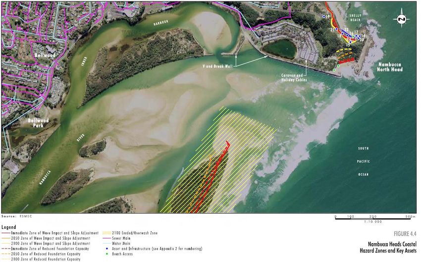
Figure 4: Hazards Zones – Nambucca Heads (South)
Source: Umwelt (2012)
Page 21Nambucca Coastline Emergency Action Subplan
Figure 5: Hazard zones - Nambucca Heads (North)
Source: Umwelt (2012)
Page 22Nambucca Coastal Zone Emergency Action Subplan
Figure 6: Hazard zones - Scotts Head
Source: Umwelt (2012)
Page 23Nambucca Coastline Emergency Action Subplan
Table 13: Valla Beach asset register
Source: Umwelt (2012)
Page 24Nambucca Coastal Zone Emergency Action Subplan
Table 14: Nambucca Heads asset register
Source: Umwelt (2012)
Page 25Nambucca Coastline Emergency Action Subplan
Table 15: Scotts Head asset register
Source: Umwelt (2012)
Page 26Nambucca Coastal Zone Emergency Action Subplan
Figure 7: Sites of slope instability
Source: SMEC, 2011 (Adapted from SMEC, 2009)
Page 27You can also read