UPDATE March 2020 - Peconic Estuary Program
←
→
Page content transcription
If your browser does not render page correctly, please read the page content below
UPDATE March 2020
PEP CCMP Revision
• The 2020 PEP CCMP is in final stages of review
  o The CCMP was submitted to the EPA January 27, 2020 –
    awaiting EPA comments for final edits and approval.

• PEP is working with a graphic design contractor
  to develop design template for the 2020 PEP
  CCMP.

• Peconic Estuary Partnership Conference
  planned for September 25th, 2020.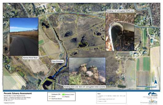
PEP’s Completed Projects!
• Check out the Priority Issues in the
  Peconic Estuary page to view
  projects PEP is moving forward!

• Check out the PEP: Making
  Significant Change page to view
  PEP’s impact in the region!
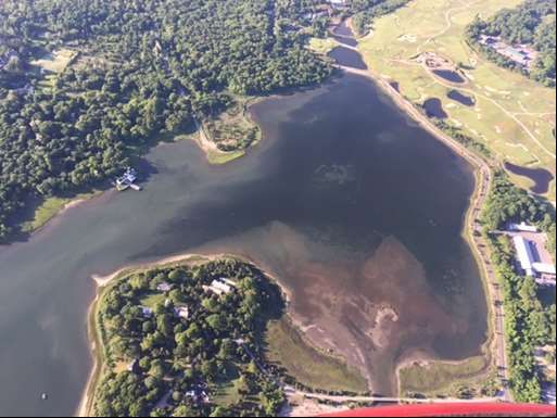
Living Shoreline Pilot Project- Greenport
  PEP and Peconic Land Trust with Cornell Cooperative Extension (CCE)
 Status: Completed August 2019, monitoring of living shoreline is ongoing.
Next Steps: Phase II of the project scope, extending the living shoreline to the
   entire property, has been developed by CCE and added to PEP Habitat
                               Restoration Plan.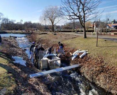
Seagrass Bio-optical Model
         PEP and The Research Foundation of SUNY Stony Brook
                  Status: Model completed September 2019.
Next Steps: Final report will be released in 2020. GIS tool is being developed.

                                         • Report includes: Site specific
                                           information to inform eelgrass
                                           management and restoration
                                           programs.

                                         • Final Seagrass Bio-optical Model
                                           results were presented at the PEP
                                           Technical Advisory Committee
                                           Agenda on February 26th, 2020.
                                           Click here for the link to the
                                           presentation: Living on the edge-
                                           analysis of Z. marina and potential
                                           for restoration- Kaitlyn O'Toole
                                           (2020)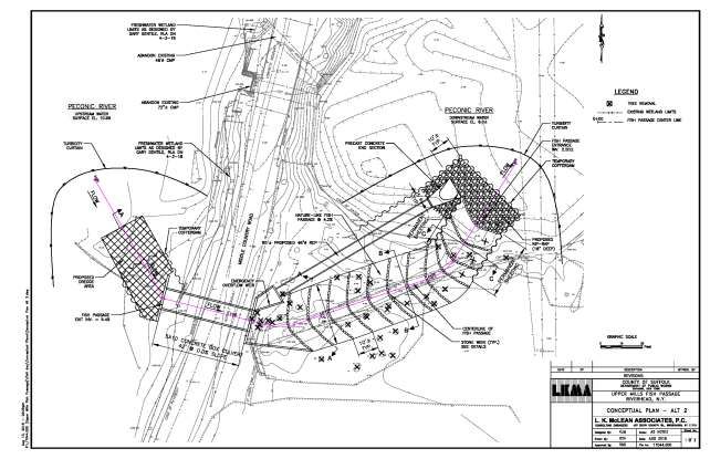
Critical Lands Protection Strategy Update
and Climate Ready Assessment Services for
    PEP and Shinnecock Indian Nation
                          PEP and Anchor QEA
 Status: Completed September 2019. Final reports available on PEP website.
 Next Steps: Municipal Training Workshops are being planned to distribute
                          tools and information.

                                        Report includes:
                                        1)Updated Critical Lands
                                        Protection Strategy (CLPS).

                                        2)Assessment of climate change
                                        vulnerabilities for both the
                                        Peconic Estuary Program and
                                        Shinnecock Indian Nation.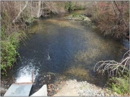
Narrow Road Wetland Restoration
Status: Completed Conceptual Habitat Restoration Design in September 2019.
             Southold Town and stakeholders reviewed plans.
          Next steps: Engineering Design Plans will be developed.
•   Narrow River is a tributary of the Peconic Bay
    and flows south from the Town’s Whitcom
    Marsh Preserve under Route 25 and along
    the eastern side of Narrow River Rd in Orient,
    NY. An earthen dam was constructed after
    the 1938 hurricane to prevent tidal flooding
    of the lands north of the dam. The western-
    most section of the dam blocked the tidal
    flow from Narrow River to the large meadow
    area north of the dam known as Broad
    Meadows and Whitcom Marsh Preserve
    north of Route 25.

•   Remediation of the culvert and earthen dam
    is needed to improve the tidal exchange
    throughout the extent of the river and
    increase the salinity of the river to promote
    the re-establishment of native vegetation
    and important waterfowl and wading bird
    habitat. The potential extent of the
    restoration area is 80 acres.

•   PEP is working with partners to secure funding
    for engineering design plans and
    construction.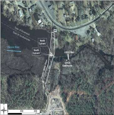
Lake Montauk Alewife Access and
             Habitat Enhancement
    Status: Completed Conceptual Habitat Restoration Design in September 2019.
                         East Hampton Town reviewed plans.
    Next steps: Partial funding secured and will move forward with construction
                         project in coordination with partners.
•     PEP recently completed a conceptual habitat
      restoration design plan to restore connectivity for
      diadromous fish species between Lake Montauk
      and Big Reed Pond by replacing an undersized
      culvert, and between Lake Montauk and Stepping
      Stones Pond by replacing an undersized,
      impassable culverts under Old West Lake Drive and
      removing debris.
•     Suffolk County Capital funds have been secured to
      replace the culvert that leads to Big Reed Pond and
      PEP staff will be working with Suffolk County parks to
      complete the permitting and construction.
•     PEP staff are also working with partners to secure
      funding to complete engineering design plan and
      construction of the culvert leading to Stepping
      Stones Pond.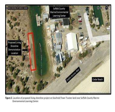
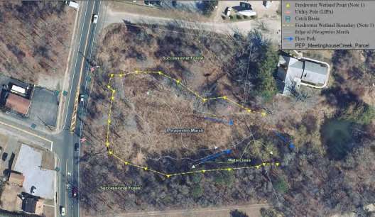
Meetinghouse Creek Main Road
    Wetland Construction/ Restoration
Status: Completed Conceptual Habitat Restoration Design in September 2019.
         Funding is secured for Engineering Design and Permitting.
 Next Steps: An RFP for Engineering Design and Permitting was advertised,
  proposals are due April 30th. PEP will begin work with selected contractor.
•   PEP recently completed a conceptual habitat
    restoration design plan for Meetinghouse
    Creek. This site is located at a large wetland
    area that forms the headwaters to
    Meetinghouse Creek in Riverhead, NY.
    Meetinghouse Creek is listed as an impaired
    waterbody on the NYSDEC Priority
    Waterbodies List. The wetland vegetation at
    this site is dominated by Phragmites.
•   The conceptual design recommendation is to
    construct a 1.2-acre stormwater wetland to
    treat stormwater runoff in the 5.6 acre
    contributing watershed. This will improve water
    quality in the downstream wetland and
    surface waters. Additionally, it will greatly
    increase the ecological quality of the habitat
    and improve plant and wildlife diversity.
•   PEP will work with the selected contractor and
    Town of Riverhead to complete the
    Engineering Design and Permitting services.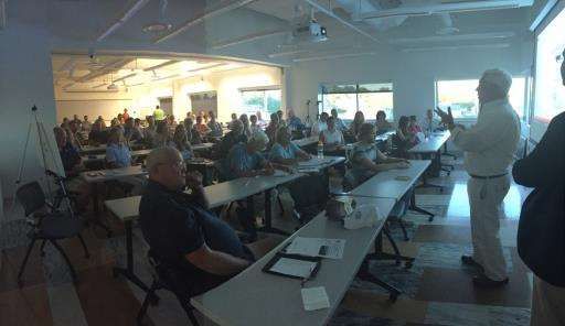
Upper Mills Dam Fish Passage
PEP and L.K. McLean Associates for engineering and permitting services
Status: Design alternative selected at April 9th, 2019 stakeholder meeting.
Developing engineering designs, designs and permitting work anticipated
                        completion February 2021.
Woodhull Dam Fish Passage
PEP and Suffolk County contracted with L.K. McLean Associates
Status: PEP has secured additional funds ($250K from Suffolk County & $50K
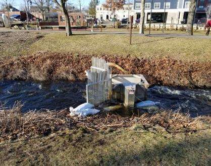
from USFWS) and hopes to complete construction in 2020.Spring 2020 Alewife Monitoring
• Video camera installed at Grangebel fishway on Peconic River for second
year. Suffolk County College Professor (Kellie McCartin) and students
helping with video monitoring analysis.
• 25 Volunteer River Herring Surveyors trained at two workshops in
February 2020.
• Alewife Monitoring QAPP under review by EPA.Expansion and Monitoring of the
Town of Southold Living Shoreline
PEP and Cornell Cooperative Extension
Status: Work is underway. Expected project completion in August 2020.
• Expansion to an existing Town of
Southold Living Shoreline Demonstration
Project.
• Goal is to establish a larger project area
and the addition of monitoring services
at the project site.
• Enable the quantification of nitrogen
and pathogen uptake of Spartina
alterniflora and ribbed mussels.Peconic Estuary Solute Transport
Model
PEP and United States Geologic Survey
Status: Model Development phase and scenario finalization.
Next project meeting tentatively scheduled for May 4th, 2020.
Link to PE Solute Transport Model Webpage
Objective: This Solute Transport Model will be a tool to
estimate time-varying nitrogen loading rates to the
Peconic Estuary
Specifically, the objectives of the investigation are to:
1) develop data sets representing current and historic
land uses relevant to nitrogen loading in coastal
watersheds
2) estimate current estuarine loading rates and
nutrient concentrations in the aquifer, and
3) use these current-condition models to simulate the
response to possible wastewater-management
actions.Hardened Shoreline GIS Mapping
Status: Hardened Shoreline GIS Mapping Project was presented at the PEP Natural
Resources Subcommittee on June 28th, 2019.
Final report is anticipated in 2020.
• PEP completed a GIS mapping project to quantify the amount
of hardened shoreline in the Estuary. The last survey was in
2003 using maps from 2001.
• The preliminary results are being reviewed and ground-truthed
in advance of final report distribution.WQ Monitoring Assessment PEP and CoastWise Partners. Status: Held workshops to review WQ monitoring programs and developed preliminary WQ targets in Peconic Estuary. Assessment will continue through out the year and is to be incorporated into CCMP. • Goal of this project is to create a PEP Monitoring Strategy that will be relevant for all decision makers. • The purpose of this project is to develop appropriate indicators of estuarine health, and ensure appropriate parameters are collected on a temporal and spatial scale to assess these indicators. The results of the project will be an updated monitoring strategy with the end goal of annual water quality Annual WQ Reporting progress: reports. 4 parameters chosen for main • Services were recommended as a WQ reporting. 3 parameters Finding of the EPA’s 2017 Program chosen to provide early warning Evaluation of the PEP. WQ monitoring.
Organizational Assessment
                            PEP and CoastWise Partners.
                                 Status: On-going

•   Management and Policy Committee Joint Retreat held October 9th,
    2019 and February 5th, 2020.
•   Examine the relationships between all groups in the Management
    Conference and provide recommendations about how they can work
    together more effectively.
•   The purpose of this project is to develop a set of guiding policies for the
    Management Conference and sub-groups.
•   Services were recommended as a Finding of the EPA’s 2017 Program
    Evaluation of the PEP.
Quality Assurance Project Plan Development for
Supplemental Water Quality Sediment Data
Collection
PEP and Tetra Tech, Inc.
Status: The project Technical Advisory Committee is reviewing the draft
Quality Assurance Management Plan. Anticipated completion September 2020.
• A NYSDEC and EPA approved Quality Assurance
Management Plan (QAMP) is under development;
• Identify and prioritize subwatersheds in the Peconic
Estuary that should be targeted for water quality
improvement activities; ensure water bodies are
properly listed on the NYS Impaired Waters list;
• Help the PEPC members and partners assess the
current baseline in water quality, and effectiveness of
water quality improvement interventions over time.Peconic Estuary Ecosystem Study
PEP, NYSDEC and SUNY Stony Brook.
Expected completion Fall 2021.
Status: Advertising for a Post-Doctoral position.
• Analyze spatial and temporal trends in the Peconic
Estuary finfish trawl survey dataset, and develop risk
metrics from ecological relationships for the Peconic
Estuary that examine whether local and regional
environmental changes have increased the vulnerability
of individual finfish and mobile invertebrate species,
community assemblages, and ecosystem processes.
• ECOSIM is a quantitative modeling framework that can
represent all major ecosystem functional groups and
can be used to identify and assess structural changes in
the ecosystem in response to environmental change.
• The proposed study will identify vulnerable species,
critical habitats, and ecosystem properties within the
Peconic Estuary.
• This information has direct application to decisions
affecting the use, management, and conservation of
the natural resources in the bay.Non-point Source Pollution
Management Project
PEP and Village of Sag Harbor.
Status: Ongoing. Expected completion September 2020.
Funding expires 9/30/2020
• Implement a non-point source pollution
management project at Havens Beach.
• The project involves utilizing green infrastructure
best management practices to treat stormwater
that would otherwise flow across the beach and/ or
through an existing discharge pipe directly to Sag
Harbor Bay.
• The project will significantly reducing the nitrogen
pollutant loads to the waterbody and improving the
overall health of the Peconic Estuary.Nitrogen Load Reduction
Assessment Project
PEP and Anchor QEA, LLC.
Status: QAPP approved. Project is ongoing. Expected completion September
2020.
Funding expires 9/30/2020
• Objective is to compile and assess the cost per
pound of nitrogen reduction to groundwater for
various nitrogen reduction best management
practices (BMPs) currently being employed
throughout the country.
• The project will provide a decision-making tool to
guide cost effective management scenarios to
reduce nitrogen on a subwatershed basis in the
Peconic Estuary.Education and Outreach Highlights • PEP has engaged alewife monitoring interns to analyze video footage taken at Grangebel Park in Riverhead to determine the number of alewife using the fishway. • During COVID-19, PEP has developed and will continue to develop new activities and educational resources for parents and teachers to utilize during this time of social distancing. This is a good time for PEP to focus on more digital engagement, revamp materials and become a resource for people. https://www.peconicestuary.org/protect-the- peconic/outreach-and-education-programs/resources-for- educators/ • Planning for the Conference, Estuary Day, & virtual event/citizen science trainings are underway.
You can also read