2017-2018 Property Assessment Division - Montana Agricultural Land Classification Manual
←
→
Page content transcription
If your browser does not render page correctly, please read the page content below
2017-2018

Montana Agricultural Land Classification
Manual

                                Property
                                Assessment
                                Division

                                Published September 23, 2016

                                                  1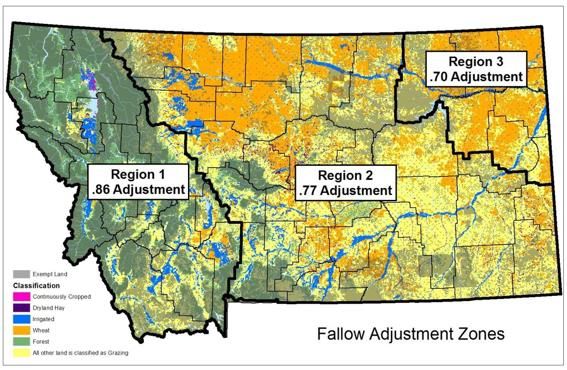
DEPARTMENT OF REVENUE

                    2017-2018
 MONTANA AGRICULTURAL LAND CLASSIFICATION MANUAL
                     January 1, 2017-December 31, 2018

                            STATE OF MONTANA

                                Steve Bullock, Governor

                  MONTANA DEPARTMENT OF REVENUE

                             Mike Kadas, Director

                                COMPILED BY

                    PROPERTY ASSESSMENT DIVISION

                     Cynthia Monteau Moore, Administrator

                        SAM W. MITCHELL BUILDING
                            125 N. ROBERTS
                               PO BOX 8018
                         HELENA, MONTANA 59601

                   The Department of Revenue prepared the

                Montana Agricultural Land Classification Manual

                          pursuant to 15-7-201, MCA.

                 The manual is available to the general public.

Please direct questions pertaining to this document to the Department of Revenue
                         Property Assessment Division at
                              http://revenue.mt.gov
                                                                                   2
Table of Contents
INTRODUCTION ............................................................................................................... 5
APPRAISER CERTIFICATION ......................................................................................... 5
HISTORY .......................................................................................................................... 6
The State Constitution ..................................................................................................... 6
2009 Reappraisal ............................................................................................................ 6
GIS .................................................................................................................................. 7
Phase-In .......................................................................................................................... 7
LEGISLATIVE AUTHORITY.............................................................................................. 8
Agricultural Property Valuation Laws ................................................................................ 9
Agricultural Property Valuation Administrative Rules ...................................................... 10
OWNERSHIPS ............................................................................................................... 11
Easements and Deeded Right-of-Ways......................................................................... 11
Conservation Easements .............................................................................................. 11
Land taken for a Public Use .......................................................................................... 12
Water Boundaries.......................................................................................................... 12
Island Ownership in Rivers ............................................................................................ 13
Contiguous vs. Noncontiguous Parcels ......................................................................... 14
APPRAISAL PROCESS .................................................................................................. 16
PRODUCTIVITY ............................................................................................................. 17
Soil Surveys .................................................................................................................. 18
General Productivity Determination Information ............................................................ 19
Non-Irrigated Farm Land ............................................................................................... 20
Non-Irrigated Continuously Cropped Hay Land ............................................................ 21
Irrigated Farm Land ....................................................................................................... 23
Grazing Land................................................................................................................. 23
Carrying Capacity Expressions ..................................................................................... 24
Calculating Carrying Capacity ....................................................................................... 27
AGRICULTURAL ELIGIBILITY........................................................................................ 31
Eligibility Requirements ................................................................................................. 32
Income Sources ............................................................................................................ 33
Ownerships of At Least 20 Acres, But Less Than 160 Acres in Size ............................. 33
Contiguous Ownerships 160 Acres or Greater In Size .................................................. 34
Noncontiguous Parcels in the Same Ownership............................................................ 34
Exceptions to the $1500 Income Requirement .............................................................. 35
Consumption of products............................................................................................... 35
Family Relationships ..................................................................................................... 35
3CLASSIFICATION ........................................................................................................... 36
Non-irrigated Summer Fallow Farmland ........................................................................ 38
Non-irrigated Continuously Cropped Farm land ............................................................ 38
Non-irrigated Continuously Cropped Hay Land ............................................................. 38
Irrigated Farm Land ....................................................................................................... 39
Grazing Land................................................................................................................. 39
Commodity Price information ........................................................................................ 40
Base Crops ................................................................................................................... 41
Crop Share .................................................................................................................... 41
Gross and Net Income .................................................................................................. 42
Capitalization Rate ........................................................................................................ 42
Irrigated Land Valuation ................................................................................................ 43
Specialty Crops ............................................................................................................. 46
NONQUALIFIED AGRICULTURAL LAND ...................................................................... 47
Nonqualified Agricultural Requirements......................................................................... 47
NONPRODUCTIVE PATENTED MINING CLAIMS ......................................................... 48
Improvements on Nonproductive Patented Mining Claims ............................................ 49
HOME SITES .................................................................................................................. 49
CADASTRAL INFORMATION ......................................................................................... 53
GEOGRAPHIC INFORMATION SYSTEM (GIS) ............................................................. 54
IMPORTANT DATES ...................................................................................................... 55
Appraisal Date ............................................................................................................... 55
Classification and Appraisal Notice ............................................................................... 55
Application for Agricultural Classification ...................................................................... 55
Request for Informal Review ......................................................................................... 55
Tax Statements ............................................................................................................. 55
4INTRODUCTION
Agriculture is the science, art, or occupation of cultivating land, raising crops, and
feeding, breeding, and raising livestock. It is also referred to as farming or ranching.
Agricultural means the production of food, feed, livestock, poultry, bees, biological
control insects, fruits and vegetables, as well as sod, ornamental, nursery, horticultural
crops and fiber commodities that are raised, grown, or produced for commercial
purposes. It also includes the raising of domestic animals and wildlife in domestication
or a captive environment. 15-1-101, MCA.
In Montana, the term livestock includes the typical domesticated animals: cattle, sheep,
swine, goats, horses, mules, and asses. In addition it also includes llamas, alpacas,
bison, ostriches, rheas, emus, and others.” 15-1-101, MCA and ARM 42.20.601.
Valuation of agricultural land in Montana is based on value in use. This means that
value is based on the capability of the land to raise a specific base crop.
APPRAISER CERTIFICATION
The Department will offer an Agricultural Land Classification/Appraisal (ALCA) class to
provide employees with appraisal training for valuing Montana’s agricultural properties.
Authority and responsibility for this task is set out in Montana Code Annotated (MCA).
Administrative rules further define the process for certification criteria. The prerequisite
for the position of an agricultural appraiser includes department certification as a
residential appraiser, as set in ARM 42.18.207. Further certification requirements
include:
1) Attend and complete ALCA training;
2) Pass the corresponding ALCA exam; and
3) Complete one year of agricultural appraisal duties on the job.
Upon appointment to an agricultural appraisal position, the appraiser must complete a
one year on-the-job internship. An agricultural certified employee will be assigned to
review all work during this time period of internship. Employees new to state government
will have their probationary period run concurrent with this internship. If an employee fails
to complete the internship satisfactorily, the result is termination or demotion to a
residential appraisal position, if such a position is available.
5After beginning the agricultural appraiser position, the employee shall enroll in the next
available ALCA training class. 15-1-201, MCA; ARM 42.18.205, 42.18.207, and
42.18.210.
HISTORY
Early taxation of property in Montana began before statehood. In 1919, a separate tax
class was developed to classify various lands including irrigated, non-irrigated tillable,
grazing, timber, cutover and mineral lands.
The State Constitution
In 1972, Montana adopted a constitution that abolished the Board of Equalization and
turned the responsibility of assessing property over to the Department of Revenue
(DOR or department).
In 1973, the department adopted rules and guidelines relating to all aspects of the
valuation of agricultural land including assignment of productivity grades. That year the
legislature passed several statutes pertaining to the valuation of these properties.
In September 1990, the governor appointed the first Agricultural Advisory Committee.
The committee reviewed their legislative mandate, evaluated agricultural income and
expense data, and recommended new valuation schedules for assessing agricultural
land. The Governor appointed members to this committee at the beginning of each
appraisal cycle. 15-7-201, MCA.
2009 Reappraisal
For the 2009 appraisal cycle, the department conducted a comprehensive classification
project to value agricultural lands. This statewide reappraisal project was endorsed by
the agricultural advisory committees of 2006 and 2008 as well as the legislature in 2005
and 2007.
Geographic Information System (GIS) technology linked aerial imagery with cadastral
(ownership) data. This information was combined with agricultural uses obtained from the
USDA Farm Services Agency. Then it was linked with soils productivity estimates for
each agricultural land use based upon statewide soil survey information from the USDA
Natural Resources Conservation Service to create productivity maps.
6The department mailed out individual parcel maps for verification by the agricultural
landowners statewide. Landowners were given the opportunity to update those maps.
The maps show current agricultural land uses as well as the land’s productivity
information and ownership and are used to maintain appraisal data and to equalize
valuation statewide.
GIS
Reappraisal activities associated with agricultural and forest lands included the use of the
most recent aerial photography along with older imagery to discover changes in
agriculture classification. The imagery used was from the National Agriculture Imagery
Program (NAIP), a nationwide program, administered by the Department of Agriculture
Farm Service Agency (FSA) Aerial Photography Field Office in Salt Lake City. The FSA
had collected NAIP imagery in Montana every 2 years since 2005. These NAIP imagery
datasets were available for agricultural appraisal activities in the department’s
agricultural/forest ArcReader maps for each county. The maps were updated annually
after assessments are completed.
Phase-In
As of 2015, agricultural land is reappraised every two years. 15-7-111, MCA.
Previous valuation cycles were 6 years in length, as a result large value changes could
have been experienced at the onset of a new cycle. The legislature attempted to mitigate
the increases between cycles by phasing in increased property values.
For Class 3, Class 4, and Class 10 properties, increases in assessed values were phased-
in incrementally over the six years of the reappraisal cycle resulting with the property
reaching its full market value in the sixth year. The difference in value from the previous
cycle was added to the previous value in 1/6 increments each year of the cycle. Any
assessed value that decreased from one reappraisal cycle to the next was fully
implemented the first year of the new reappraisal cycle.
Agricultural land with productivity only changes used the previous cycle value to
determine the amount of value change. Those properties with land use changes or
size changes used a calculated value before reappraisal (VBR) to determine the
difference in value. A VBR was the full reappraisal value from the previous appraisal
cycle. A calculated VBR was electronically calculated by using the current property
data (land use, size, and productivity) in the previous cycle calculations.
7LEGISLATIVE AUTHORITY
The department classifies and values more than 50 million acres of privately owned
agricultural land in Montana. The statutes governing the appraisal and classification of
agricultural land are located in Title 15 of the Montana Code Annotated.
Montana law currently requires the department to value all agricultural property once
every two years, 15-7-111, MCA. The department values agricultural property based on
its productivity using a productivity valuation formula. This formula will be discussed in
detail later in the manual. All agricultural land is placed in one of five sub-classes:
1. Non-irrigated summer fallow farmland
2. Non-irrigated continuously cropped farmland
3. Irrigated land
4. Grazing land
5. Continuously cropped hay land
The department is charged with the general administration and supervision of
assessment laws. The department must assure that all property assessments comply
with the law, are fair and equitable, and accurately represent value. 15-1-201, MCA.
The department must maintain current classification of all taxable lands.15-7-101, MCA.
The department is also required to set and maintain uniform and equitable procedures
for reclassification. 15-7-103, MCA.
The department uses the same agricultural appraisal methods and assessments
statewide. This provides equalization across the state. 15-7-112, MCA. The end result
is that similar properties have substantially equal taxable values.
8Agricultural Property Valuation Laws
Below are the statutes that the Montana Department of Revenue follows in appraising
agricultural properties:
15-1-101 Definitions
15-1-201 Administration of revenue laws
15-6-133 Class three property – description – taxable percentage
15-6-134 Class four property – description – taxable percentage
15-6-201 Exempt categories
15-6-207 Agricultural producer exemption--…. low value
buildings, implements, and machinery
15-7-101 Classification and appraisal – duties of the department of revenue
15-7-102 Notice of classification and appraisal to owners-appeals
15-7-103 Classification and appraisal – general and uniform methods
15-7-107 Certification required
15-7-108 Land split
15-7-111 Periodic revaluation of certain taxable property
15-7-112 Equalization of valuations
15-7-201 Legislative intent – value of agricultural property
15-7-202 Eligibility of land for valuation as agricultural
15-7-203 Agricultural uses only considered in valuation
15-7-206 Improvements on agricultural land
15-7-207 Continuance of valuation as agricultural land
15-7-208 Reclassification by department
15-7-209 Tax on change of use of part of tract
15-7-212 Tract crossing county line-whole
15-8-111 Assessment – market value standard-exceptions
15-8-201 General assessment day
15-8-307 Land assessment
76-6-208 Taxation of property subject to conservation easement
9Agricultural Property Valuation Administrative Rules
The Montana Department of Revenue follows these rules in appraising agricultural
properties:
42.20.156 Agricultural and forestland land use change criteria
42.20.301 Application for classification as nonproductive, patented mining
claim
42.20.302 Definitions (mining claims)
42.20.303 Criteria for valuation as mining claim
42.20.304 Additional Restrictions that curtail preferential treatment
42.20.305 Valuation of acreage beneath improvements on eligible mining
claims
42.20.307 Valuation of Eligible Mining Claim Land
42.20.601 Definitions
42.20.602 Steps in determining the classification of agricultural land
42.20.603 Valuation of agricultural land that does not have a published soil
survey
42.20.604 Steps in determining the productivity of agricultural land
42.20.606 Exceptions to agricultural land assessment
42.20.610 Classification and appraisal of easements on agricultural land
42.20.615 Application for agricultural classification of land
42.20.620 Criteria for agricultural land valuation for land totaling less than
160 acres in size
42.20.630 Production failures
42.20.635 Marketing delay for economic advantage
42.20.640 Valuation of land ownerships 160 acres or larger in size
42.20.645 Classification and assessment of those portions of any
Agricultural, Nonqualified Agricultural, or Forest Land parcels that
are Residential, Commercial, or Industrial sites
42.20.650 Valuation of Nonqualified agricultural land from 20 to 160 acres
42.20.655 Valuation of one-acre beneath improvements on agricultural and
Nonqualified agricultural land
42.20.660 Non-irrigated summer fallow farmland
42.20.665 Non-irrigated, continuously cropped farm land
42.20.670 Non-irrigated continuously cropped hay land
42.20.675 Tillable, irrigated farmland
42.20.680 Grazing land
42.20.681 Agricultural commodity prices and values
42.20.682 Family Farm
42.20.683 Specialty and Unique Crops
10OWNERSHIPS
Eligibility for agricultural classification is based on ownership of the parcel(s). Ownership
is defined by the International Association of Assessing Officers (IAAO) as the rights to
use the property, to the exclusion of others. Fee simple ownership includes all the rights
and interests in the property except the governmental rights such as taxation, eminent
domain, police power, and escheat.
Easements and Deeded Right-of-Ways
An easement is a property right held by one party to use specific land owned by
another party and entitles its holder to a specific limited use or enjoyment. An easement
may be created and held by either private or public entities. The easement may be
temporary or held in perpetuity.
Easements are not specifically addressed in the agricultural valuation statutes.
Easements that do not transfer title are taxable to the owner of record. Roads, irrigation
ditches, or power line easements that do not transfer title are taxable and are valued
according to the productivity of the underlying soils. 15-7-206, MCA.
A deeded right-of-way is conveyed through a deed or other instrument. A record of the
ownership conveyance must be available in the local county clerk and recorder’s office.
An example of a deeded right-of-way is a state highway. These conveyances, often
done without a survey defining boundaries, state the number of acres in the right-of-way.
In these cases the right-of-way acreage is placed into a right-of-way classification on the
parcel record. When a survey defines the boundaries, the right-of-way acreage is
deducted from the original ownership and placed into a right-of-way parcel. If the
deeded right-of-way acres originally come from two ownerships, the department
allocates equal amounts of acreage from both ownerships into the right-of-way. ARM
42.20.610.
Conservation Easements
A conservation easement is a voluntary transfer of specific property ownership rights,
interests, and benefits to another for conservation purposes, such as limiting future
development. The deed for a conservation easement gives the oversight of the land’s use
to a governmental agency or a private non-profit conservation organization and limits the
rights of subsequent property owners. In Montana, the easement may be in perpetuity or
for a term of at least 15 years.
The Montana Open-Space Land and Voluntary Conservation Easement Act was adopted
11in 1975 and provides that no property tax advantages are granted due to the
establishment of a conservation easement on Class 3 property. The land must be
classified based on the restricted uses that are permitted by the easement. But this
classification, if it is only because of the creation of the conservation easement, cannot
result in a property valuation lower than it had prior to the easement. This means that
Class 4 property cannot be reclassified as Class 3 or Class 10 merely because the
property is placed into a conservation easement.
For example, a landowner that places a conservation easement on a parcel of tract land
cannot be reclassified to Class 3-agricultural land, merely because of the easement. The
property must still meet agricultural eligibility requirements.
In the previous example, the easement may impact the property’s Class 4 market value.
The loss of development rights may reduce the value of the property and the department
must recognize this reduction in value. The department does not appraise property
rights. Therefore, the landowner must provide the department with a fee appraisal that
meets USPAP standards from a certified private appraiser.
Although rare, a conservation easement may cause a property to change to a different
property class if the easement prohibits agricultural use in its entirety.
If the conservation easement is properly renewed within 15 days of its expiration, the
department will not reclassify the land. 76-6-208, MCA.
Land taken for a Public Use
Land classified as agricultural land that has been reduced in size for a public use will not
lose its agricultural classification due to the reduction, 15-7-202, MCA. For example a 20
acre parcel of land classified as nonqualified agricultural land is reduced to 18 acres to
allow the widening of a state highway. This parcel continues to be classified as
nonqualified agricultural land. Public uses are described in 70-30-102, MCA.
Water Boundaries
Private ownership boundaries described by a non-navigable stream, river, lake, or pond
are set at the midpoint or thread of the stream. Private ownership boundaries that follow a
navigable stream, river, lake, or pond are along the high water mark of the stream bed,
river, or lake. Private ownership boundaries that follow an easement such as a road also
go to the centerline of the easement, unless stated differently in the deed.
12In some cases, the centerline or midline of a river or stream denotes a county boundary.
If the river or stream channel meanders from year to year, the county boundary does not
change with the alteration of the centerline or midline.
Ownership boundaries may change due to alterations in a stream or riverbed.
When the stream deposits silts and soils, a slow, imperceptible growth called
accretion takes place. Under Montana law, accreted land belongs to the owner of
the property benefiting from the accretion. 70-18-201, MCA.
The slow erosion of the stream bank, called reliction, results in an unnoticeable
loss of property. On the other hand, when the stream removes the bank in a fast
and sudden manner the original owner of the bank has the right to reclaim it within
one year after it is deposited elsewhere. 70-18-202, MCA. Avulsion, a sudden
change in the course of a river or stream often caused by spring floods, may cause
a shift of the ownership boundary.
The department must have validation from a court to change ownership boundaries
or taxable acreage due to any of these circumstances. This ensures that the
boundary change is valid and avoids litigation of ownership boundaries.
Island Ownership in Rivers
Islands located in navigable streams belong to the state unless a private party holds the
title. This includes abandoned stream beds of navigable streams and lakes, all islands in
these streams that have not been surveyed, and any lands that were previously a part of
an island in a navigable stream or lake. 70-18-203, MCA.
Islands located in unnavigable streams belong to the property owner that owns that side
of the stream. If the island straddles the centerline of the stream, the island ownership
boundary is divided by a continuation of the stream center line. 70-18-204, MCA. When a
stream cuts a new channel and forms an island, the land remains in the same ownership
as it was prior to becoming an island. 70-18-205, MCA.
Ownership of an island created by accretion is given to the state if the following steps
are taken.
1. The state claimed ownership by filing quiet title.
2. The court awarded the ownership to the state.
13Contiguous vs. Noncontiguous Parcels
In order to determine the amount of land attributable to one owner, one must understand
the concepts of contiguous and noncontiguous. The department criteria for contiguous
parcels is that the parcels must be in identical ownership and share a common boundary.
Contiguous parcels can be separated by the following:
1. parcel boundary lines
2. a navigable stream
3. a deeded road or highway
4. railroad lines
5. government land leased by the property owner whose parcels the government land
is bordering.
All land in the same legally defined parcel is contiguous in ownership. In other words, a
parcel may include man-made features such as easements and county boundaries, or
natural features such as streams, and still be contiguous. ARM 42.20.601.
The following examples demonstrate the concepts of contiguous and noncontiguous
parcels.
Example 1
A landowner owns two, 10-acre tracts of land. A highway is located between these two
tracts.
1. Both parcels are in the same ownership.
2. The parcels would touch if not separated by the highway.
These parcels are contiguous and in one ownership for the entire 20 acres.
14Example 2
A landowner owns two, 10-acre tracts of land in the same ownership. The Missouri River
separates the two tracts. One tract is located in Cascade County and the other tract in
Chouteau County.
1. Both parcels are in the same ownership.
2. The parcels would touch if not separated by the river.
The parcels are contiguous and the landowner’s total ownership is 20 acres in size.
Example 3
A landowner owns two, 80-acre parcels of land. The parcels are separated from each
other by a state section of land. The landowner leases the section of land from the State
of Montana.
Leased
State Land
Tract Tract
A B
1. Both parcels are in the same ownership.
2. The parcels would touch if not separated by the government land which is
leased by the landowner of Tracts A and B
Tracts A and B are contiguous so the landowner’s contiguous ownership is 160
acres in size.
15Example 4
A landowner owns two, 10-acre tracts of land. The tracts touch each other at one
corner.
Tract A
Tract B
1. Both parcels are in the same ownership.
2. The parcels touch each other.
The parcels are contiguous making the landowner’s contiguous ownership 20
acres in size.
Example 5
John Doe owns Tract A and Tract C. John Doe’s wife, Mary Doe owns Tract B.
Tract Tract Tract
A B C
1. Joe Doe is one ownership for parcels A and C.
2. Mary Doe is a different ownership for parcel B.
Tract A and Tract C, owned by John Doe, are noncontiguous to each other.
APPRAISAL PROCESS
Maintenance of the classification and productivity information on agricultural land is an
on-going process involving appraiser input and review as well as the Department’s GIS.
Staff classifies land according to its use. Montana’s land classifications include:
1. class three agricultural land;
162. class three patented nonproductive mining claims;
3. class three nonqualified agricultural land;
4. class four land;
5. class ten forest land.
When agricultural land use changes occur, an appraiser must review information
provided by the landowner and aerial photos and identify the field boundaries associated
with each land use.
The appraiser must identify the agricultural classifications on the map:
F for non-irrigated summer fallow farmland;
C for non-irrigated continuously cropped farmland;
I for irrigated land;
G for grazing land;
H for continuously cropped hay land; and
S for specialty crop.
PRODUCTIVITY
The department determines each soil’s ability to produce crops or sustain livestock. The
department refers to this as the productive capacity or the soil’s ability to produce forage
in the specific environment of the subject location under typical management.
17Productivity is determined based on the characteristics of each soil.
Prior to the 2009 reappraisal, productivity of agricultural land was rated using a
grade. Each grade represented a range of productivity for that agricultural use. A
statewide comprehensive review of productivity grades had not occurred since the
mid 1970’s or earlier. Beginning with the 2009 reappraisal, the department began
determining the productivity of all agricultural land using the United States
Department of Agriculture Natural Resource Conservation Service (NRCS) soil
survey. 15-7-201, MCA.
Soil Surveys
A soil survey is a scientifically based detailed analysis and report of the characteristics
and properties of the different components of the soils within a given area. A uniform and
consistent system for determining soil productivity requires a strict set of procedures.
Those procedures are defined and detailed in the NRCS Land Capability Classification
System.
The information for determining agricultural land productivity are the soil map and the
tabular data containing estimated crop yields of grain and alfalfa hay, estimated carrying
capacity for irrigated and non-irrigated domestic pastures, and forage production on native,
non-irrigated rangeland.
The productivity information is based on a high level of management and/or ideal climatic
or environmental conditions while the department is required to determine the agricultural
income based on the production of a typical Montana farm or ranch. As a result most
productivity estimates from the soil survey are adjusted.
Individual soil surveys are normally limited to one county soil survey updates are posted to
the Web Soil Survey located on-line. Updated soil surveys can be located at
http://websoilsurvey.sc.egov.usda.gov/App/WebSoilSurvey.aspx.
Changes in agricultural technology and management have generally increased crop
yields over the last 30 to 40 years. Higher production levels may be the result of more
efficient farm machinery and improved farming techniques such as crop rotation,
fertilization and irrigation. In addition, advanced pesticides and herbicides have helped to
increase crop yields.
Soils, the basis of production, are a product of climate, living organisms and parent
material. Soils consist of water, air, and solid material, including sand, silts and clays. Soil
materials are arranged in layers called soil horizons. The collective sequence of soil
horizons is called a soil profile.
18Soils high in soluble salts such as sodium chloride, magnesium sulfate & calcium
chloride, are referred to as saline soils. Soils high in sodium are referred to as sodic
soils. Saline and sodic soils have poor physical condition, high pH and are difficult to
manage.
Topography, slope and aspect, influences soil characteristics and soil moisture.
Thus, topography may influence soil productivity. Soil depth may also impact
crop and livestock production. Shallow soils have lower moisture retention than
deeper soils. As a result deeper soils may influence production during dry years.
Different soil types don't necessarily have different levels of production. Farming
techniques may vary from one soil to another resulting in similar yields even though the
soils are different in many aspects. Similar soils in an area generally show similar
responses in production due to a change in farming methods.
General Productivity Determination Information
Determining the productivity of agricultural land is the process of using the soil survey
information and assigning a production value or yield/acre that represents the long-term
average agricultural production capacity for a given acre of land. When applicable for an
area, an adjustment to the soil survey productivity estimate is determined and applied
throughout the area. Adjustments may also be made when producers within a general
area provide sufficient evidence that the productivity estimate as determined in the soil
survey does not accurately reflect production levels for the area.
Soil productivity is the output of a specified plant or group of plants under a defined set of
management practices. It is the single most important evaluation for farming. In general, if
irrigation is an optional practice, yields are given with and without irrigation. Productivity
can be expressed in quantity of a product per unit land area, such as bushels or tons per
acre. For pasture, productivity can be expressed as the carrying capacity of standard
animal units (AUM) per unit area per season or year. The soil survey productivity may
also be expressed as a rating or index related to either optimum or minimum yields, or it
may be indexed to a set of soil qualities (properties) that relate to potential productivity.
Productivity indices have the advantage of being less vulnerable to changes in
technology than are expressions of productivity based on yields. The determination of
productivity is based upon the production information contained in the NRCS soil survey.
When calculating productivity, the department considers typical management practices.
Good managers are not penalized with above average productivity levels and poor
managers are not rewarded with below average productivity levels. For instance, if the
19majority of farms in an area are achieving similar yield responses on a particular soil
type and they are using accepted management practices, the productivity determination
fits the production received by the majority.
Any acreage of reasonable size is delineated if a measurable variance in productive
capacity is determined. Generally, five acres is the minimum resolution for productivity
differences within a use class.
Land under farm buildings, irrigation ditches, road easements, water bodies, and brush-
lined creeks are valued based on the productivity rating set for adjacent or surrounding
land. Land under farm buildings and other man-made developments should be classified
as grazing land, but is not assigned an arbitrarily low grazing productivity.
Non-Irrigated Farm Land
Non-irrigated farmland includes non-irrigated summer fallow farmland and non-irrigated
continuously cropped farmland. These lands produce farm crops without applying
additional water to the land. Non-irrigated farmland productivity is determined based on
the amount of spring wheat that can be produced per acre.
Spring wheat is set as the base crop because it is the most common small grain crop
grown in Montana in both number of acres planted and number of bushels produced. It
also can be grown in all locations of the state whereas other small grains have
limitations. Although spring wheat can be grown in all locations, it is not always the crop
of choice.
The department uses the NRCS soil survey as the basis for this productivity. The spring
wheat productivity information from the soil survey is adjusted to determine the
productive capacity under typical management. The state is divided into three regional
growing areas, each with an adjustment factor. This adjustment factor is determined by
comparing the soil survey rating and the twelve year weighted average of spring wheat
as published for the counties in the region as reported to Montana Agricultural Statistical
Services. The department adjusts the NRCS productivity ratings by the appropriate
regional factor to calculate an average production under typical management. The
following map shows the current regional non-irrigated farm land adjustments.
20Non-Irrigated Continuously Cropped Hay Land
Non-irrigated continuously cropped hay land is also called “dry land hay”, or “wild hay”
land. This land classification is described in more detail in the Classification Section later
in this manual.
Productivity of non-irrigated continuously cropped hay land is based on the total
production of vegetation as published in the NRCS soil survey. The soil survey publishes
data for total air-dried herbage, called air-dry vegetation, for each soil under favorable,
normal and unfavorable conditions. The department uses the midpoint of the air-dry
vegetation produced at normal and unfavorable conditions when determining the
productivity of non-irrigated hay land. This productivity is divided by 2,000 to arrive at
tons/acre.
When there is a naturally high water table present, sub-irrigation occurs. Sub-irrigation
often results in higher productivity. Sub-irrigated fields are classified as non-irrigated hay
land, rather than irrigated land. Typically, non-irrigated hay land produces only one
cutting annually and sub-irrigated hay land often produces two cuttings per year.
21Fertilization is not considered typical management for dryland hay land.
Aftermath grazing refers to the use of a hay field for livestock grazing after the final hay
harvest of the year. The soil survey includes aftermath grazing in its productivity
estimate.
When discussing yield issues with a producer, any aftermath grazing should be included
with the producer’s estimate of productivity. Typically, aftermath grazing adds 25% to
33% to the land’s total productivity. In order to estimate total productivity, the operator’s
hay production records must be adjusted to include the aftermath grazing when
comparing it to the department’s estimate of productivity.
The following two examples demonstrate how operator production data may be
identical, but different management practices produce different production estimates.
Example 1 (Includes aftermath grazing from July 20-January 1)
10-acre hay field
One cutting of non-irrigated hay per year
285 hay bales produced, 80-pound hay bales
Total production: 285 bales * 80 pounds per bale = 22,800 pounds of hay
Production/acre: 22,800 pounds per ton ÷ 10 acres = 2,280 pounds per acre
Tons/acre: 2,280 pounds per acre ÷ 2000 pounds per ton = 1.14 tons
Aftermath grazing: 1.14 tons per acre * 1.333 = 1.52 tons per acre
Producers estimate of Productivity: 1.52 tons per acre
Example 2 (No livestock aftermath grazing)
10-acre hay field
One cutting application per year
285 hay bales produced, 80-pound hay bales
Total production: 285 bales * 80 pounds per bale = 22,800 pounds of hay
Production/acre: 22,800 pounds per ton ÷ 10 acres = 2,280 pounds per acre
Tons/acre: 2,280 pounds per acre ÷ 2000 pounds per ton = 1.14 tons
Producers estimate of Productivity: 1.14 tons per acre
Example 1, including aftermath grazing, produced a productivity rating higher than that
of Example 2 with no aftermath grazing.
22Irrigated Farm Land
Irrigated farm land is tillable crop land that has water applied to it the majority of the
years. It does not include irrigated grazing land. This land classification is described later
in this manual in the classification section on Irrigated Farm Land.
The productivity of tillable irrigated farmland is based on the amount of alfalfa the land
is capable of producing as provided by the NRCS soil survey. Alfalfa hay is set as the
base crop because it is the predominant irrigated crop grown in Montana. Operators
often include alfalfa hay production in their cropping sequence and are knowledgeable
about alfalfa hay productivity.
Irrigation generally increases the productivity rating of the land. The type of soil becomes
less important to production as the amount, quality, and consistency of irrigation
increases. For example, irrigated hay land typically produces two to three cuttings
annually, while non-irrigated hay land generally receives only one cutting per year.
Fertilization can increase productivity and is considered a typical practice for irrigated
land.
The department does not change the productivity rating of irrigated land due to a
different irrigation system. The productivity estimate will be the same regardless of the
type of irrigation system being used.
Aftermath grazing may occur on irrigated farm land. Aftermath grazing is discussed in
detail in the preceding Non-irrigated Continuously Cropped Hay Land section.
Among other things, the NRCS productivity estimate is based on alfalfa at its highest
point of production. The department bases valuation on the typical production so this
rating may need to be adjusted. The adjustments are based on producer input related to
the amount of water regularly applied to the land and average productivity. Adjustments,
based on the percent of difference detected between the soil survey productivity rating
and the reported productivity, are applied to the NRCS soil survey productivity for
irrigated land within each county.
Grazing Land
Grazing land is land used primarily for livestock forage. The majority of Montana’s
agricultural land is grazing land, mostly native rangeland. The productivity of grazing
land is based on the carrying capacity or number of animal unit months the land is
23capable of sustaining as published by the NRCS soil survey. The rating from the NRCS
is based on what the soil would have produced in its natural state when all factors
associated with productivity were in natural equilibrium.
Carrying capacity represents the number of animal units the land can support for a
specific time period without causing injury to the land. In other words it is the amount of
grazing that a pasture can sustain due to the qualities of the soil and the environment
where it occurs. ARM 42.20.601.
Stocking rate represents the number of animal units an operator actually places on the
land. Stated in other terms it is the number of specific animals grazing or utilizing a
piece of land for a specific period of time.
Carrying capacity is not always equal to the actual stocking rate. It may be increased by
management practices such as pasture rotation and developing water systems.
Fertilization, weed spraying and mechanical treatments are not considered typical
management practices for grazing land. While management decisions may improve
rangeland carrying capacity, the department does not penalize the producer with higher
productivity ratings.
Grazing land productivity is based upon the soil’s ability to produce palatable plants for
livestock forage. Livestock graze on both poor and good rangeland. They prefer the
bottomlands and areas near water, while grazing less on areas with steep hillsides, less
desirable forage, and areas located at distance from their water source. Livestock
grazing preferences depend on plant palatability, nutrition value, stage of plant growth,
stocking rate, season of use, relative abundance, availability, and site location.
Overgrazing occurs when the stocking rate is greater than the carrying capacity. Under
grazing occurs when the stocking rate is less than the carrying capacity of the land. The
department does not reduce the land productivity rating due to poor management
practices such as overgrazing.
Carrying Capacity Expressions
Productivity and carrying capacity are discussed in acres per animal unit month
(Ac/AUM) or total animal unit months (AUM). These terms describe relationships
between the number of animals and the acres grazed.
24Term Abbreviation Description
Animal Units AU number of animal units
Animal Unit amount of forage needed to sustain an animal unit for one
AUM
Months month
AUM per Acre AUM/Ac number of animal unit months that one acre can support
number of acres required to support one animal unit for
Acres per AUM Ac/AUM
one month
number of animal unit months that the land area can
Total AUM AUM
support
Animal Units
An animal unit, the base measurement for productivity, is one cow-calf pair or its
equivalent. A cow-calf pair consists of a 1,200 cow with a calf up to six months old. The
following table shows some of the animal unit equivalencies for other livestock.
Livestock Animal Unit
Equivalent
Horses
3 year old and over 1.25
2 year old 1.00
Yearling .75
Sheep
Ewe .20
Buck .25
Goats
Mature .15
Yearling .10
Wildlife
Bison Bull 1.30
Bison Cow 1.00
Bison Yearling .60
Elk .70
Mule Deer (mature) .30
Whitetail Deer (mature) .20
Antelope (mature) .20
Bighorn Sheep (mature) .20
Animal units are added together to determine the total animal units. For example a
rancher has 50 cows each with a calf for a total of 50 animal units.
25Example (using equivalencies):
A rancher owns 25 cow/calf pairs, 2 bulls, 5 two-year old steers and 100 sheep. The total
animal units is calculated as follows:
animal
head count type equivalency units
25 cow/calf pairs = 25
2 bulls = 2
5 steers = 5
100 sheep X .20 = 20
Total animal units = 52
The rancher owns a total of 52 animal units.
Animal Unit Months
An animal unit month (AUM) is the amount of vegetation required to feed one animal unit
for one month. It is also a product of animal units and grazing time. This relationship is
stated in the following equation and possible combinations that result.
AUM = animal units x months of grazing
For example, a pasture that supports 12 animal unit months could be used in any of the
following combinations:
12 animals for 1 month or 1 animal for 12 months
6 animals for 2 months or 2 animals for 6 months
4 animals for 3 months or 3 animals for 4 months
Grazing seasons are based on the typical period that livestock are able to graze without
causing injurious effect to the overall health of the vegetation. The grazing season may
extend from before the spring green-up of pastures to beyond the fall frost. The amount
of time that the animals are allowed to graze the land, or length of grazing season,
impacts the number of animal units that a parcel of land can support. The department
makes no determination on the length of time that livestock can graze on the land.
Generally, the department’s total carrying capacity rating and the producer’s stocking rate
have a close correlation. The department does not determine which combination of time
and animal units is best as this is the producer’s management decision.
Animal Unit Months/Acre
The department uses the term animal unit months/acre (AUM/Ac) when determining the
productivity of grazing land. AUM/Ac expresses carrying capacity in the number of
26months that an animal unit can graze on one acre of land. AUM/Ac are determined by
dividing the animal unit months by the number of grazing acres that are grazed. ARM
42.20.601.
Acres/Animal Unit Month
Productivity and carrying capacity are often discussed in acres per animal unit month
(Ac/AUM). This term is another expression of the relationship between the number of
animals and the acres grazed for one month.
Calculating Carrying Capacity
The department uses the NRCS soil survey estimate for the pounds of air-dry forage in
its determination of the carrying capacity for grazing land. The soil survey publishes air-
dry herbage estimates for favorable, normal and unfavorable growing conditions. The
department uses air dry herbage estimates for unfavorable conditions. This helps account
for non-palatable herbage which may be included in the soil survey estimate. It also
accounts for the fact that most privately owned rangelands in Montana do not exist in
climax ecological conditions. Montana State University College of Agriculture
recommended the use of this method.
The air-dry herbage estimate from the soil survey is adjusted to reflect the amount of
forage that is actually consumed by livestock. The department uses a 25% grazing
efficiency factor. Ranchers typically allow livestock to eat ½ of the available forage. This is
referred to as the “take half-leave half” grazing philosophy and is a widely accepted
method of managing grazing lands. It is intended to leave enough of the plant to allow for
vigorous regrowth. It is then assumed that ½ of the remaining herbage is not available for
livestock use due to trampling, insect use or damage, and wildlife use, leaving ¼ of the
total herbage available for use by livestock.
Example:
Total air dried herbage under unfavorable conditions = 1,500 pounds
Take ½, leave ½ management = 750 pounds
½ wasted = 375 pounds (amount of forage available to livestock)
The department converts this estimate of forage produced into animal unit months per
acre using the following steps. First the feed requirements of an animal unit month are
calculated based on a daily feed requirement of 3% of the animal’s weight. This equates
to 36 pounds of air-dry forage.
AU Daily feed = 1200 pounds x 3%=36 pounds
27Then the daily requirement is multiplied by 30.5 days to convert the feed requirement to a
monthly equivalent.
1 AUM = (36 pounds per day) x (30.5 days per month) = 1,098 pounds.
The third step involves multiplying the amount of air dry herbage by the grazing efficiency
factor to determine the forage available for livestock intake.
vegetation production (from unfavorable conditions) x .25 = actual livestock forage
The fourth step results in the animal unit months/acre with the following calculation.
actual livestock forage ÷ 1098 pounds = animal unit months
Since the NRCS soil survey data is in pounds per acre, the above calculation results in
animal unit months per acre.
Here is an example of calculating the carrying capacity.
Given:
Annual air-dry forage production (unfavorable) = 900 pounds per acre.
One AUM = 1,098 pounds.
25% grazing efficiency factor
Find: AUM/Acre
1. vegetation/acre x grazing efficiency factor = livestock consumption
900 x .25 = 225 pounds per acre
2. 225 pounds consumed per acre/1098 pounds/AUM = 0.20 AUM/acre
3. Stated another way, it would take 5 acres of land to support one animal unit for
one month. This expression, acres per animal unit months is the reciprocal of the
previous step. It is calculated by dividing animal unit months/acre into 1.
1 ÷ .20 AUM/Ac = 5 acres/AUM
As shown the terms AUM/Ac and Ac/AUM are reciprocals of one another. In a
reciprocal relationship, when one of the expressions is known, the other can be
determined by dividing the known expression into one (1). Examples of reciprocals are
as follows:
1. AUM per Acre converted to Acres per AUM
1 ÷ .25 AUM/Ac = 4 Ac/AUM
282. AUM per Acre converted to Acres per AUM
1 ÷ 4 Ac/AUM = .25 AUM/Ac
This shows the relationship between these expressions. An animal unit grazes one acre
of land for ¼ of a month. This in turn means that 4 acres are required to provide one
month’s forage for the animal unit.
The department uses .043 AUM/Ac as the lowest productivity placed on grazing land as
recommended by the 2006 Governor’s Agricultural Advisory Committee.
When the expression AUM is divided by the number of acres in the pasture, the
expression AUM/Ac is the result. For example, 20 AU X 5 months = 100 AUM then if the
pasture used to graze the livestock is 300 acres, then to calculate the expression
Ac/AUM, simply divide the acreage by the AUM (300 Acres ÷ 100 AUM = 3 Ac/AUM).
The following examples demonstrate the calculation of AUM/acre and acres/AUM.
Example 1
An operator grazes 25 animal units for 2 months on 200 acres.
1. Animal unit months per acre (AUM/Ac)
50 AUM ÷ 200 Acres = .25 AUM/Ac
2. Acres per animal unit month (Ac/AUM’s)
200 Acres ÷ 50 AUM = 4 Ac/AUM
Example 2
An operator grazes 25 cows with calves (cow/calf pairs) and one bull on a 180-
acre pasture. The livestock spend a total of four months of the grazing season in
the pasture to avoid overgrazing the native vegetation.
There are 26 animal units.
25 cows/calves pairs + 1 bull = 26 AU
There are 104 animal unit months.
26 animal units x 4 months = 104 AUM.
29There are .58 animal unit months per acre.
104 animal unit months
180 grazing acres = .58 AUM/Ac
There are 1.73 acres per animal unit month
180 grazing acres
104 animal unit months = 1.73 Ac/AUM
One animal unit can be supported for one month on 1.73 acres.
Example 3
A 100-acre pasture has a carrying capacity of 2.0 Ac/AUM. The operator grazes
12 mature horses. The grazing season is 10 months.
The animal units are calculated as follows:
12 horses X 1.25 AU equivalent = 15 AU
There are 15 animal units.
We calculate animal unit months as follows:
100 acres
= 50 AUM
2.0 Ac/AUM
There are 50 animal unit months.
The productivity in animal unit months per acre is calculated as follows:
50 AUM
= .50 AUM/Ac
100 acres
There are .50 animal unit months per acre.
If the livestock graze each acre 15 days per month, we calculate the number of
months as follows:
30 days/month x .50 AUMs/Ac = 15 days
50 AUM
= 3.33 months
15AU
3015 animal units (12 horses) can graze for 3.33 months of the grazing season on
this pasture.
Example 4
A pasture has a carrying capacity of 3.0 Ac/AUM. We calculate the acres required
to support 30 AUM as follows:
X = 31 AUM
3.0 Ac/AUM
X = 31 AUM x 3.0 Ac/AUM
X = 93 Acres
This pasture requires 93 acres to support 31 animal unit months of total carrying
capacity.
Example 5
A 30-acre pasture has a carrying capacity of 2.5 Ac/AUM. We calculate the total
carrying capacity as follows:
30 acres
=12 AUM
2.5 Ac/AUM
AGRICULTURAL ELIGIBILITY
Although land may be used in an agricultural manner, it must also meet specific
eligibility criteria to receive agricultural land classification for property taxation purposes.
The criterion used depends on the size of the parcel of land. 15-7-202, MCA.
Parcel size is important as this determines the various income sources allowed to meet
the qualifications of agricultural land classification. In general the different parcel size
categories are described as:
1. Parcels of land consisting of 160 acres or more under one ownership
automatically receive agricultural land classification unless the land is used for
other purposes. Owners of these parcels are not required to apply for
agricultural classification nor prove agricultural income. These parcels are taxed
at the agricultural rate.
2. Parcels of land containing 20 acres or more but less than 160 acres under one
ownership is eligible for classification as agricultural land if application has been
submitted and approved. These parcels are taxed at the agricultural rate.
3. Parcels of land containing 20 acres or more but less than 160 acres that do not
31You can also read