2021 Pre-Season Hurricane Outlook - May 2021 - Acrisure
←
→
Page content transcription
If your browser does not render page correctly, please read the page content below

2021 Pre-Season Hurricane
Outlook
May 2021
2021 Pre-Season Hurricane Outlook
                         May 2021

Contacts
           Name: Simon Hedley                         Name: Michael Cross
           Location: New York                         Location: Burlington
           Phone:                                     Phone:
           +1 212 792 8905                            +1 336 603 1469
           Email:                                     Email:
           SHedley@AcrisureRe.com                     MCross@AcrisureRe.com

           Name: Rick Thomas                          Name: Clark Hontz
           Location: Zurich                           Location: Bermuda
           Phone:                                     Phone:
           +41 78 669 17 40                           +1 441 296 2772
           Email:                                     Email:
           RThomas@AcrisureRe.com                     CHontz@AcrisureRe.com

            Name: Jeff Turner                         Name: David Sowrey
           Location: Toronto                          Location: London
           Phone:                                     Phone:
           +1 416 847 5440                            +44 (0) 20 7680 8394
           Email:                                     Email:
           JTurner@AcrisureRe.com                     DSowrey@AcrisureRe.com

                                                      Name: Marc Piccione
                                                      Location: New York
                                                      Phone:
                                                      +1 646 665 7561
                                                      Email:
                                                      MPiccione@AcrisureRe.com

                         Acrisure Re | Acrisure.com | 0
2021 Pre-Season Hurricane Outlook
                               May 2021

Contents
Section 1. Executive Summary                                    2
Section 2. Atlantic Sea Surface Temperature                     4
Section 3. Tropical Pacific Sea Surface Temperature (ENSO)      8
Section 4. Saharan Dust                                         12
Section 5. Ongoing Volcanic Activity                            13
Section 6. Intraseasonal Variability                            14
Section 7. Conclusions                                          15
References                                                      16

                               Acrisure Re | Acrisure.com | 1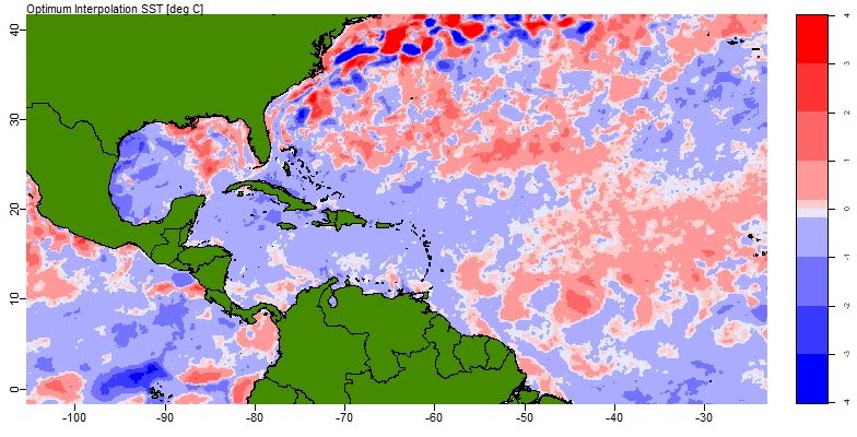
2021 Pre-Season Hurricane Outlook
                                 May 2021

Section 1. Executive Summary
This year, seemingly as usual, a consensus of forecasts is indicating an above average
season.

As we do each year, we have looked at some of the key persistent variables behind the
forecasts to provide context.

   •   The Atlantic Multi-decadal Oscillation (AMO) and Atlantic Sea Surface Temperature
       (SST) are lower than last year, which lends to a less active Hurricane Season than
       2020, although still elevated above average.

   •   The El Nino Southern Oscillation (ENSO) looks likely to be Neutral, compared to a
       La Nina phase last year which resulted in weaker vertical wind shear, and less
       atmospheric stability and therefore more hurricane activity. A Neutral phase of
       ENSO tends not to promote generation of storms in the Main Development Region
       as much as La Niña.

   •   Neutral and positive ENSO are associated with higher landfall rates for Gulf clusters
       in the Acrisure Re forecast model, so there could be reasons for concern there.

   •   Past Analog years of 1976 and 2011 would indicate Quasi-Biennial Oscillation (QBO)
       is trending to a negative anomaly. Recent publications and an Acrisure Re analysis
       of historical storms have not been able to show significant impact of the QBO on
       overall hurricane activity, but it has been claimed that positive QBO values are
       associated with more Cape Verde storms forming in the deep tropics.

   •   Conditions in the Sahel region of Africa appear wetter than normal. This potentially
       means less dust in the atmosphere above the Main Development Region which can
       suppress hurricane formation.

   •   The ongoing eruption of La Soufriere volcano in Saint Vincent could potentially
       supress activity this season as volcanic ash and aerosols act similarly to Saharan
       dust warming the stratosphere and cooling the ocean surface.

The 2020 hurricane season was unprecedented in many ways. The extremely active 2020
Atlantic hurricane season got off to a fast start with a record nine named storms from May
through July. Many other records were set including a record-breaking 30 named storms
and 12 landfalling storms in the continental United States. The 30 named storms in 2020
surpassed the previous record of 28 set in 2005. Overall, 13 of the named storms became
hurricanes which was the second-highest number of hurricanes on record. The
contributing factors to the active season included much warmer-than-average Atlantic sea
surface temperatures, along with much weaker vertical wind shear and wind patterns.
                                Acrisure Re | Acrisure.com | 2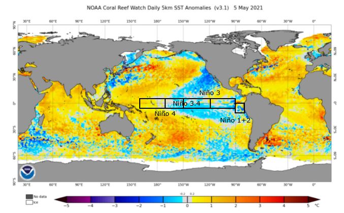
2021 Pre-Season Hurricane Outlook
                                  May 2021

Notably the AMO index, a measure of Atlantic sea surface temperature was at its highest
level since 1948 in February and March of 2020. These conditions, combined with La Nina,
helped make this a record-breaking hurricane season.

We are also continuing to see the trend of extremely slow moving/stalling hurricanes. The
most recent examples include Harvey, Florence, Dorian and Sally. If a storm is slow
moving or stationary, it means that the rainfall and destructive winds will last longer,
prolonging the threat. Hurricane Sally brought the highest observed water levels since
Hurricane Katrina in 2005 to Pensacola, Florida. The Naval Air Station Pensacola
reported more than 24 inches of rain as the storm’s forward movement slowed to walking
speed along the coast. Hurricane Laura pushed a storm surge up to 18 feet above ground
level into southwestern Louisiana, one of the highest readings on record in that state. The
slowing down of forward speeds adds another threat as we look ahead to the 2021
hurricane season. (Kossin, 2018)

            Fig. 1: Hurricanes stalling for two days or more by percent. (Source: Tim
                                Hall/NASA and Jim Kossin/NOAA)

                                 Acrisure Re | Acrisure.com | 3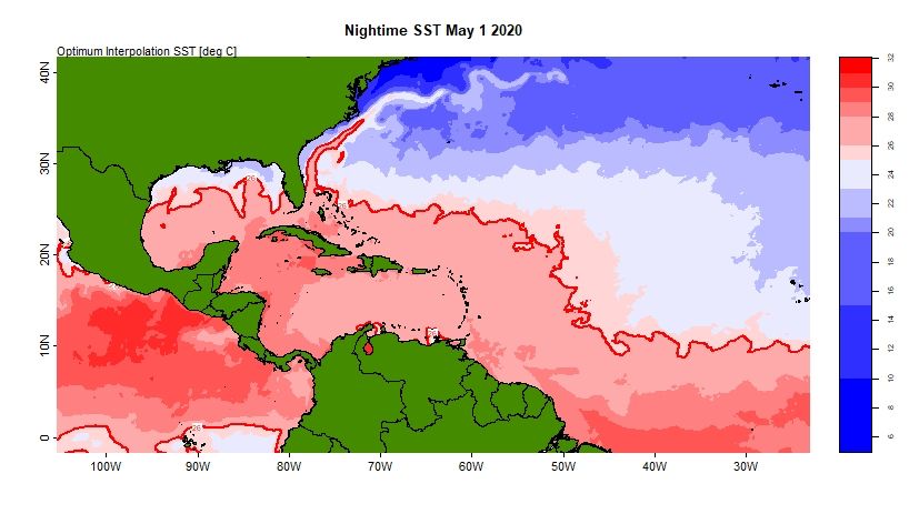
2021 Pre-Season Hurricane Outlook
                                 May 2021

Section 2. Atlantic Sea Surface Temperature
Hurricanes require minimum sea surface temperatures in excess of 26.5°C (79.7°F)
before they can form, as they are effectively heat engines powered by warm ocean water.
High sea surface temperatures alone do not ensure we will have an active season, but
there is strong association between positive Atlantic Sea Surface Temperature (SST)
anomalies and active seasons.

Currently, the sea surface temperatures are cooler than they were in May last year,
particularly around Florida, the western Gulf of Mexico and the Caribbean Sea. This is not
particularly clear in the SST maps shown in Fig 2 but is apparent in the difference map
shown in Fig 3.

               Fig 2: Nightime Sea surface temperatures for May 1, 2021 and May 1,
                   2020. The 26°C contour is shown as a red line (Source: NOAA)

                                Acrisure Re | Acrisure.com | 4
2021 Pre-Season Hurricane Outlook
                                 May 2021

If this distribution of sea surface temperatures persists, the cooler Gulf and Caribbean Sea
surface waters should be less conducive to rapid intensification than they were last
season.

Although current SST patterns are strongly correlated with what we are likely to see in the
peak hurricane months of August and September, it is very useful to look at predictions as
well. We include two examples below where the predicted SST data is presented as
temperature anomalies. Anomalies are defined as deviations from the mean temperature
calculated for a specific reference period. Positive anomalies, where the water is warmer
than average, are shown in red, and blue is used to denote areas where it is cooler. The
examples we show are from the NMME (North American Multi model Ensemble) and the
ECMWF (European Centre for Medium range Weather Forecasting). Direct comparison is
difficult as the plots are based on different reference periods for mean temperature and
represent the forecast data in different ways. The NMME plot is the anomaly in degrees,
whereas the ECMWF is a probability that it will exceed a given tercile in the overall
distribution of SST.

Both show cooler conditions in the Caribbean Sea compared to the same forecasts last
year and suggest that both the western part of the Gulf and a substantial part of the Main
Development Region are likely to be cooler than last year. This should favor a less active
season with less major Hurricanes than last year.

                    Nightime Sea Surface Temperature
                     Difference (May 2021-May 2020)

                                   Main Development Region

           Fig. 3: Sea surface temperature difference in the North Atlantic from May
           1, 2020 to May 1, 2021. Blue areas are colder than 2020 (Source: NOAA)

                                Acrisure Re | Acrisure.com | 5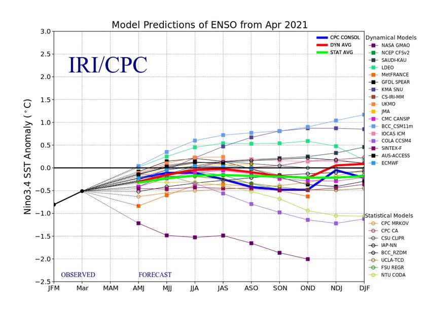
2021 Pre-Season Hurricane Outlook
                                  May 2021

Atlantic Multi-decadal Oscillation (“AMO”)
Atlantic SST appears to oscillate with a period of multiple decades and has been linked by
numerous studies with changes in numbers of hurricanes. This sea surface temperature
variation is often quantified using the AMO index, calculated by averaging the SST across
the whole Atlantic and is frequently used for statistical hurricane prediction. Though AMO
indices can be defined using a couple of different approaches, there is general agreement
that we have been in a positive phase since 1995, and that this positive phase has been
associated with an above average numbers of hurricanes.

The AMO can be forecasted using SST forecast models, and Acrisure Re uses the North
American Multi Model ensemble’s six-month predictions alongside a statistical model to
create a six-month AMO forecast.

 Fig. 4: Annual Atlantic Multidecadal Oscillation (AMO) index values since 1856 The multi decade
             periods of positive and negative AMO are clearly visible (Source: NOAA)

Last February and March saw the highest values of the AMO since 1950. Although it did
not remain at record levels, it remained very high throughout the season, which fits with

                                 Acrisure Re | Acrisure.com | 6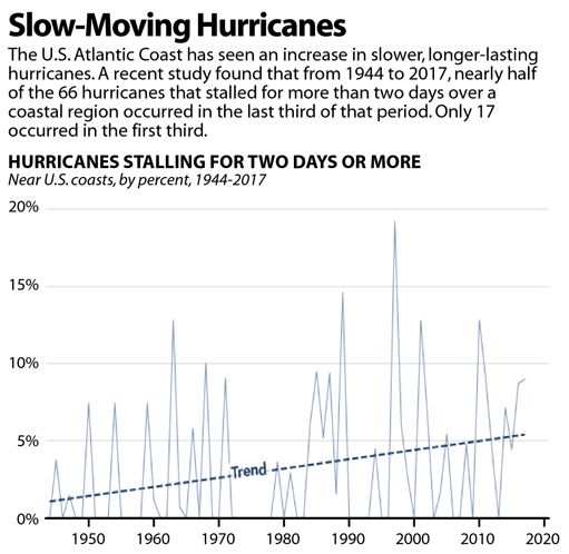
2021 Pre-Season Hurricane Outlook
                                 May 2021

the highly active 2020 season. This year’s outlook is for AMO values closer to 2019 than
2020 levels, consistent with above average activity but not suggestive of an exceptional
season.

                                                                                 Actual AMO
                                                                                 Acrisure Re Forecast

 Fig 5: The unsmoothed AMO index since 2010 (black) and a Acrisure Re forecast for 2021 (red).
  The Acrisure Re forecast is based on a combination of North American Multi-model Ensemble
(NMME) six monthly sea surface temperature forecasts, and statistical techniques (Source: NOAA)

                                Acrisure Re | Acrisure.com | 7
2021 Pre-Season Hurricane Outlook
May 2021
Section 3. Tropical Pacific Sea Surface Temperature (ENSO)
There is a strongly established link between the sea surface temperatures in the Tropical
Pacific and hurricane activity. There are a range of indices used to quantify SST in the
Pacific, and they all oscillate with a period of 3-7 years, defining what is known as the El
Nino Southern Oscillation (ENSO). The NINO 3.4 Index is the most widely used in
forecasts.
Fig 6: The regions used to
calculate the various ENSO
indices. One of the most
commonly used indices is a
three-month average of the
NINO3.4 index. (source: BOM,
Australia)
Fig 7: 5km Global SST Anomalies (source: NOAA)
Acrisure Re | Acrisure.com | 82021 Pre-Season Hurricane Outlook
May 2021
ENSO has been linked to a wide range of additional climate variations including Pacific
typhoon activity, rain in California and tornado activity in parts of the US. Warm (positive)
phases of ENSO, El Nino events, are associated with above average wind shear in the
Atlantic at latitudes where stronger hurricanes normally form leading to below average
activity. La Nina (negative ENSO) events are conversely associated with more favorable
conditions for Atlantic hurricane formation, and more active seasons. There is some
evidence that US landfall probability is also dependent on ENSO conditions, though this is
only true for hurricanes that form in the Western Atlantic and Gulf of Mexico.
Interestingly, US landfall probabilities (per storm) may increase in Neutral and El Nino
months, which partly counteracts the reduction of overall hurricane numbers in positive
ENSO months.
Fig. 8: April forecast plume ENSO defined as the NINO 3.4 Index averaged over 3 months.
There are a range of dynamic and statistical models used to forecast ENSO, and generally the
consensus forecasts shown in solid blue, green and red have more skill than most individual
forecasts. The consensus is Neutral conditions for the key months of the hurricane season
(Source: IRI/CPC)
Acrisure Re | Acrisure.com | 92021 Pre-Season Hurricane Outlook
May 2021
This year we have slightly cooler than average surface waters across much of the tropical
pacific, with a shift from La Nina to Neutral conditions having occurred in early May this
year. This is forecast to continue as shown in the forecast plume in fig 8.
Last year, ENSO conditions at the peak of the Hurricane season were more negative than
predicted, by between 0.3 and 1°C, which was consistent with the high level of activity.
This year, if we get Neutral or even slightly positive ENSO, it is unlikely that significant
suppression of activity will occur. In fact, statistical studies carried out by Acrisure Re
have shown increased rates of landfall for some types of hurricanes, particularly along the
Gulf coast, under Neutral conditions.
Acrisure Re | Acrisure.com | 102021 Pre-Season Hurricane Outlook
May 2021
The Quasi-Biennial Oscillation
The Quasi-Biennial Oscillation (QBO) is a regular ‘see-sawing’ of winds in the tropical
stratosphere. A westerly QBO (a positive anomaly relative to average winds) enhances
hurricane formation near the Equator by reducing wind shear over the Tropics.
Conversely, an easterly QBO (negative anomaly) reduces hurricane formation near the
Equator by increasing wind shear over the Tropics.
Recent publications and some proprietary analysis by Acrisure Re have been unable to
show significant impact of the QBO on overall hurricane activity, but it has been claimed
that positive QBO values are associated with more Cape Verde storms forming in the deep
tropics. The Acrisure Re proprietary analysis indicates that the QBO potentially increases
the number of Cape Verde storms in September. Interestingly, last year the QBO switched
back from a negative phase unusually quickly to become positive during the key months
of the Hurricane season, potentially enhancing the already active season. This rapid
switch back from a negative phase has not been observed in any other year since 1948,
although in 2016 the QBO failed to go negative at all. Given these two anomalous changes
in recent years the QBO is potentially worth studying in more detail if only to understand
why its ”oscillation” has become less predictable.
Fig. 9: QBO showing values since 2010. 2016 was a very unusual year with the QBO failing to oscillate
to negative values for the first time since measurements began. 2018 marked a return to normal
behavior, returning to positive values at the end of the year. Based on both analogue years, and
statistical model analysis, QBO looks set to transition back to negative later this year. (Source: NOAA)
This year the QBO looks likely to be entering a negative phase at the start of the
hurricane season and become increasingly negative throughout the season. Hence,
although QBO only has a minor impact on hurricane activity, it does not look likely to
enhance activity this year.
Acrisure Re | Acrisure.com | 112021 Pre-Season Hurricane Outlook
May 2021
Section 4. Saharan Dust
During the hurricane season, Saharan dust can have a significant effect on hurricane
activity, as dust inhibits activity in three key ways:
1) Dust absorbs relatively more infrared radiation than a dust free atmosphere, and
thus heats up the atmospheric layers where it is present. In summer, the dust is
generally transported out over the Atlantic at heights of a few kilometres, hence
well within the lower atmosphere. The creation of a warm layer at relatively low to
mid-level within the troposphere (lowest layer of the atmosphere where all of
Earth’s weather occurs) inhibits the rising of warm moist air from near the ocean
surface, and thus suppresses the convection required to generate the
thunderstorms that develop into tropical storms and hurricanes.
2) The SAL (Saharan Air Layer) contains large amounts of dust that reflect incoming
solar radiation which in turn causes sea surface temperatures to cool, reducing the
amount of energy available and impacting the likelihood for storms to develop into
Hurricanes.
3) The strong winds associated with the SAL can increase vertical wind shear, which
can lead to hurricane dissipation.
The Saharan dust is produced by erosion of soil in Saharan Africa, and this erosion is
more pronounced when the dust producing regions are dry. Hence the rainfall in the
Western Sahel (near Saharan Africa), has a direct link with the amount of dust available
to transport, and hence the rate of Hurricane formation in the Atlantic.
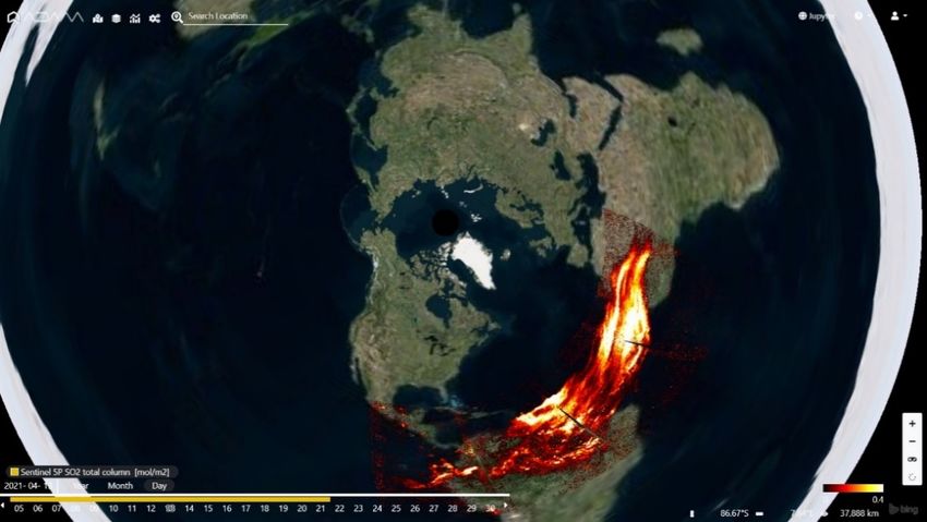
The current precipitation data, and that for the last three months indicate no substantial
anomaly.
Figure 10: Precipitation anomaly
map of Africa as of March 2021.
(Green colors) represent areas of
higher than average precipitation
and the (brown colors) represent
areas of lower than average Sahel Region
precipitation. Approximate western
Sahel Region shown on map.
(Source: IRI, Columbia University)
Acrisure Re | Acrisure.com | 122021 Pre-Season Hurricane Outlook
May 2021
Section 5. Ongoing Volcanic Activity
The variation of SST in the Atlantic has been associated with many possible drivers
including atmospheric pollution from industry, and volcanic eruptions. Recent publications
by Pausata and Carmago 2019 and Evan 2012 have suggested that the cooling effects of
volcanic ash and sulphur aerosols may have played a more significant role than was
previously thought.
Global cooling from the 1982 El Chichon eruption in Mexico, and the larger 1991 eruption
of Mt. Pinatubo in the Philippines have allowed volcanologists and atmospheric physicists
to better understand and model potential effects. Although it was a relatively small
eruption, El Chichon had significant effects on the atmosphere due to the large volume of
sulphur dioxide it injected into the stratosphere. This material led to stratospheric
warming of 4°C and cooled the north hemisphere by 0.4-0.6°C. Pinatubo ejected
considerably more material into the stratosphere overall, but was less sulphur rich leading
to an overall global cooling of 0.6°C.
Currently La Soufriere volcano (which literally means Sulphur mine) is erupting on St
Vincent. In April, a couple of large explosions sent ash up to a height of 10 km (basically
the edge of the Stratosphere), and that ash was carried east into the Atlantic by the
prevailing high-level winds. The eruption is continuing with lava dome extrusion ongoing,
and it is quite possible that further ash clouds may be ejected to similar heights later in
the season because of partial lava dome collapse.
In conclusion, although
this does not look set to
be a significant climatic
eruption, its location just
on the edge of the main
development zone has
potential to disrupt
Hurricane activity with
local stratospheric
warming and cooling of
the sea surface in the
Main Development
Region.
Figure 11: Image showing Sulphur from La Soufriere (Source:
Copernicus/ECMWF)
Acrisure Re | Acrisure.com | 132021 Pre-Season Hurricane Outlook
May 2021
Section 6. Intraseasonal Variability
While the above factors may impact the big picture for the season, there are some
variables that influence the month-to-month variations in tropical cyclone formation. For
example, the Madden-Julian Oscillation (MJO) has been shown to effect when hurricanes
form. The MJO is an eastwardly migrating tropical wave that traverses the equator every
30 to 60 days. It is characterized by an area of enhanced rainfall and an area of supressed
rainfall. Tropical storms and hurricanes are more likely to form when the area of enhanced
precipitation is moving over the ocean, especially the Gulf of Mexico and Caribbean. In
regions of below average convection, hurricane activity is diminished.
Another feature that impacts when storms may form are convectively coupled Kelvin
waves (CCKW). These are also eastward-propagating tropical waves but move much
faster than the MJO. CCKWs can influence tropical cyclone formation by enhancing
convection (rainfall) and triggering African easterly waves (AEWs) which are known to be
a main precursor for hurricanes to form over the Atlantic in the Main Development Region.
These two types of tropical waves, as well as Saharan dust mentioned above, can have a
large impact on when and where hurricanes form in the Atlantic basin throughout the
season. Saharan dust is generally more active early in the season and supresses activity if
there is a large concentration. The MJO and CCKWs can occur throughout the season and
can facilitate or hinder the development of storms depending on the phase. These
phenomena are hard to predict in the short-term, let alone the long-term, so they are of
little use when forecasting for the entire season. But they are very important during the
season and they bear watching.
Acrisure Re | Acrisure.com | 142021 Pre-Season Hurricane Outlook
May 2021
Section 7. Conclusions
There are many groups making pre-season hurricane forecasts, and this report is
designed to help put those forecasts into context. We have examined several key
variables that have been associated with hurricane activity in numerous published
scientific studies to create a qualitative overview of the likely conditions this summer.
Atlantic sea surface temperatures are currently not as high as last year particularly based
on AMO, which was at its highest level since 1950 last March. It remains to be seen
whether the lower temperatures will persist into the key months of the hurricane season
itself but given that forecasts also indicate a cooler Atlantic this year we can be
reasonably confident of a slightly above average AMO, and hence slightly above average
Hurricane season.
ENSO looks likely to be Neutral this year, which in contrast to last year’s La Nina,
conditions are associated with average levels of hurricane activity in the Atlantic.
Considering the variables, we discuss in this report, AMO and ENSO are most strongly
associated with variations in Atlantic Hurricane activity. Hence with one set to be slightly
more favorable than average and the other set to be bang on average, current indications
favor a season slightly above long term in terms of activity.
Additional suppression of activity is possible if the QBO shifts to negative this summer and
enhances wind shear, but this is likely to be a secondary effect. A slightly wetter Sahel
may mean enhance formation due to less Saharan dust than usual this year, but the
influence of the Volcanic activity in St Vincent may counteract that.
Overall, we appear set for a much less active season than last year, (which is not saying
much as last year was the most active season on record!), but the key variables still
indicate we will still have an above average season again in 2021.
Acrisure Re | Acrisure.com | 152021 Pre-Season Hurricane Outlook
May 2021
References
A global slowdown of tropical-cyclone translation speed
James P. Kossin
Nature volume 558, pages104–107 (2018)
https://www.nature.com/articles/s41586-018-0158-3.pdf?origin=ppub
Tropical cyclone activity affected by volcanically induced ITCZ shifts
Francesco S. R. Pausata and Suzana J. Camargo
PNAS Volume 116 (16) 7732-7737 (2019)
https://www.pnas.org/content/116/16/7732
Atlantic hurricane activity following two major volcanic eruptions
Amato T. Evan
JGR Volume 117, issue D6 (2012)
https://agupubs.onlinelibrary.wiley.com/doi/full/10.1029/2011JD016716
Acrisure Re | Acrisure.com | 162021 Pre-Season Hurricane Outlook
May 2021
Confidentiality Notice
This document, including any attachments, is solely for the use of the intended addressee
and may contain privileged and/or confidential information. If you are not the intended
recipient, you must not make any use of this documents or its attachments. Please
immediately notify the sender and destroy all copies of this document and its attachments
using industry accepted data destruction methods.
If you retain this document and its attachments, by doing so, you fully consent:
• to use this information only for the purposes for which it was provided, ensuring
that such information remains privileged, is kept confidential and protected from
unauthorized use, disclosure, alteration, destruction or distribution;
• to abide by all laws and regulations applicable to our Client and the Acrisure Group
of companies which govern the treatment of data including that of natural persons;
and
• to only distribute such information to parties when necessary for the fulfilment of
the business purpose and who have consented to these or materially alike
provisions contained in this article;
You further consent to follow the reasonable instructions of our Client and/or the Acrisure
Group of companies, or their agents, made time to time to ensure that such data, whether
held by you, or the parties to which you have distributed it to, is maintained in accordance
with this article, including but not limited to consenting to data security audits.
In order for our Clients or Acrisure to meet their obligations you further consent to
immediately notifying Acrisure in writing in the event of a breach of this article or when
you have been contacted by a natural person concerning their personal data.
Irreparable harm may arise to the parties supplying this information, including data
subjects, for which financial remedies may be inadequate and therefore the forenamed
parties retain the right to seek injunctive relief (or similar process), including under laws
to which the aforementioned parties are subject to, when necessary to ensure that the
information provided is afforded the expected duty of care or remedy in the event of
unauthorized use of data.
Acrisure Re | Acrisure.com | 172021 Pre-Season Hurricane Outlook
May 2021
Disclaimer
Acrisure Re and its affiliates ("we", "us" or "our") provide the information contained within
this document on an as is basis solely for the use of the intended recipient and for
informational purposes only. We make no representation, guarantee, or warranty,
whether express or implied, including any as to the accuracy, completeness, timeliness,
satisfactory quality or fitness for any particular purpose or use of any information
contained herein.
We may have relied on data provided by an insurer, reinsurer, managing general agent,
public data and other sources when preparing this information. Such information, and our
related calculations, projections, forecasts and estimates, are derived from or based on
sources believed by us to be reliable, but we do not guarantee the correctness or accuracy
of such information, calculations, projections, forecasts or estimates. All forward-looking
statements in this document are subject to various risks and uncertainties that could
cause results to differ materially from expectations. Users should not place reliance on
such forward-looking statements or any other information contained herein.
We shall not be liable, under any circumstances, to any user or other person for any
direct, special, indirect, incidental, consequential, punitive or damages of any other kind,
or for lost profits or lost opportunities associated with this information including but not
limited to the underlying data, the actuarial methods used in the analysis of the data and
the resulting information. We do not accept any liability associated with the use of this
information and no duty of liability is owed to any party unless agreed otherwise in writing
by us.
This document and the information contained herein constitute our property, which may
include trade secrets, and such document and information shall not be distributed by the
recipient to any other party without our prior written approval. Our rights in respect of
this are reserved, including seeking damages for unauthorized use of the document
and/or the information contained therein and/or seeking injunctive or other similar relief.
Acceptance of this document is deemed agreement to the terms set forth in this
Important Notice.
Acrisure Re | Acrisure.com | 18You can also read