2701 LONGFIELDS DRIVE STONEBRIDGE PHASE 16 PLAN OF SUBDIVISION + ZONING BY-LAW AMENDMENT
←
→
Page content transcription
If your browser does not render page correctly, please read the page content below
•   \

2701 LONGFIELDS DRIVE
STONEBRIDGE PHASE 16
PLAN OF SUBDIVISION +
ZONING BY-LAW AMENDMENT

          September 24, 2020   Planning Rationale
Prepared for:

Mattamy Homes
50 Hines Road, Suite 100
Ottawa, ON K2K 2M5
mattamyhomes.com

Prepared by:

Fotenn Planning + Design
223 McLeod Street
Ottawa, ON K2P 0Z8
fotenn.com

September 2020
CONTENTS

1.0 Introduction ..........................................................................................................................................................1
2.0 Site Context and Surrounding Area .....................................................................................................................2
3.0 Proposed Development .......................................................................................................................................5
4.0 Policy and Regulatory Context ............................................................................................................................9
5.0 Supporting Studies ........................................................................................................................................... 16
6.0 Conclusions ...................................................................................................................................................... 17

 Planning Rationale                                                                    Mattamy Homes                                                 September 2020
1.0                                                                                                         1
INTRODUCTION
Fotenn Consultants has been retained by Mattamy Homes (“Mattamy”) to prepare a Planning Rationale in
support of Plan of Subdivision and Zoning By-law Amendment applications for Phase 16 of Mattamy’s
Stonebridge community (“subject lands”). This Planning Rationale is prepared in support of a new submission of
supporting materials, following a first submission in July 2018 (D02-02-18-0060/D07-16-18-0018).

The subject lands currently comprise a portion of the Stonebridge Golf Course, and are proposed to be removed
from the golf course lands to accommodate the subdivision. The 18-hole golf course will be maintained, with a
modification to the course configuration to accommodate the holes and fairways.

The golf course lands are legally described as Part of Lot 7 and 8 Concession 2, in the Geographic Township of
Nepean, City of Ottawa.

The proposed subdivision consists of 184 residential units, including a mix of detached and townhouse units.
The subdivision also contains a parkland block and pedestrian walkway, all functioning as a new, stand-alone
phase of the residential community.

The Zoning By-law Amendment proposes to rezone the subject lands to permit the proposed uses. Specifically,
the following zones are proposed:

      •   Residential Third Density Subzone YY (R3YY) to permit the low- and medium-density residential land
          uses; and

      •   Parks and Open Space Zone (O1) to permit the proposed park.

Full details of the proposed zoning are summarized in Appendix A of this Planning Rationale.

1.1       Background
Stonebridge is a predominantly residential community developed by Monarch Corporation and now owned by
Mattamy Homes at the southern edge of the urban boundary in Barrhaven. The community is generally bound by
Greenbank Road to the west, Prince of Wales Drive to the east, the existing urban boundary to the south and the
Jock River to the north. Upon completion, the community will have approximately 3,000 homes.

This application for Plan of Subdivision and Zoning By-Law Amendment seeks to permit the development of
Phase 16 of the Stonebridge community.

 Planning Rationale                                       Mattamy Homes                        September 2020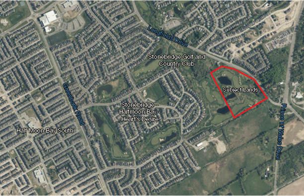
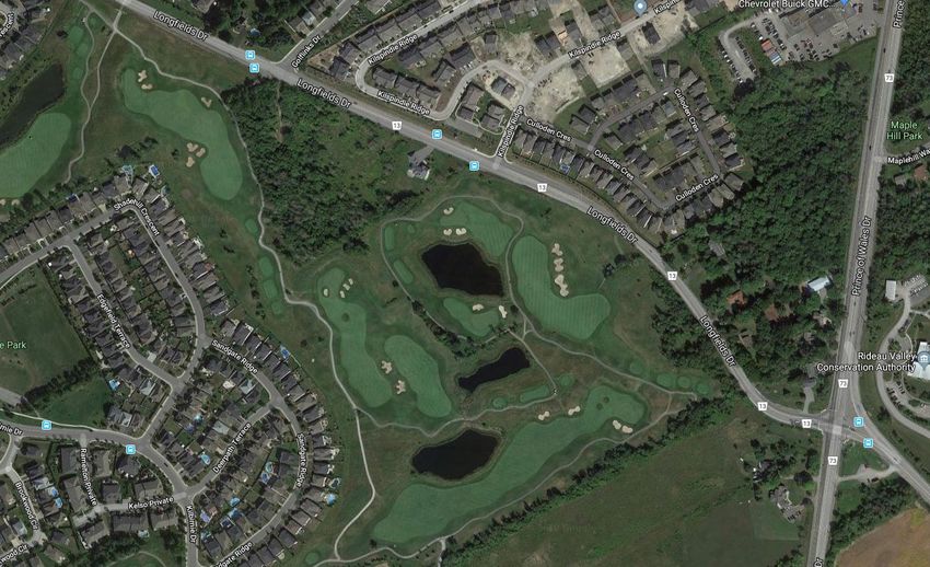
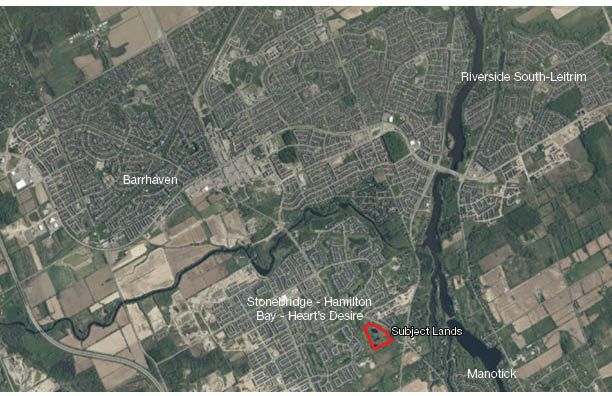
2.0                                                                                                             2
SITE CONTEXT AND SURROUNDING AREA
2.1     Subject Lands
The subject lands are located in Barrhaven South, at the edge of the urban boundary. The lands are generally
bounded by existing Longfields Drive to the east, rural lands to the south, a portion of the existing golf course to
the west, and a Uniform subdivision (Grandview Court) at 2741 Longfields Drive to the north. Figure 1 shows the
subject lands in the regional context.

Figure 1: Subject Lands in City Context

The subject lands are 10.6 hectares in area, comprising a portion of the 73-hectare Stonebridge Golf and
Country Club. The balance of the Golf and Country Club located outside of the subject lands will continue to
function as a golf course. The new residential development will be separated by approximately 130 metres of
golf course holes and fairways to the existing dwellings to the west. The retained golf course area will function as
a buffer to the new community phase. The proposed subdivision will ultimately result in the reconfiguration of
existing holes 5, 6, 7, and 8 of the golf course. Figure 2 illustrates the subject lands in a local context.

 Planning Rationale                                        Mattamy Homes                          September 2020
3

Figure 2: Subject Lands in Local Context

2.2     Surrounding Area

North
A residential subdivision developed by Uniform (Grandview Court) containing a mix of low- and medium-density
residential uses is forthcoming north of the subject lands. The Minto Recreation Complex, which offers a range
of amenities such as gymnasiums, a pool, ice rinks, and sports fields, is located at the southeast corner of the
intersection of Cambrian Road and existing Greenbank Road, approximately 1.2 kilometres northeast of the
subject lands. The Barrhaven Town Centre Mixed Use Centre is located approximately 3 kilometres to the north
of the subject lands. Approximately 5 kilometres north of the subject lands is the Fallowfield Road interchange,
connecting motorists with Highway 416.

East
Prince of Wales Drive, a north-south arterial providing access to the downtown core, is located directly east of
the subject lands. Several city-owned parks including Maple Hill, Beryl Gaffney and David Bartlett are located
east of the site along the Rideau River.

West
The Stonebridge Golf and Country Club is located directly west of the subject lands. Existing residential
development from previous phases of the Stonebridge development borders the western boundary of the Golf
Club. These surrounding communities contain a mix of low- and medium-density residential uses, as well as

 Planning Rationale                                       Mattamy Homes                September 2020
4

schools and parks. Further west of the site, a Community Core comprised of a mix of commercial and higher-
density residential uses is planned at the intersection of Cambrian Road and realigned Greenbank Road in
accordance with the Barrhaven South CDP (2006).

South
The City’s rural area is located south of the subject lands, with the closest village being the Village of Manotick
approximately 1.2 kilometres to the southeast.

 Planning Rationale                                         Mattamy Homes                September 2020
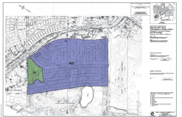
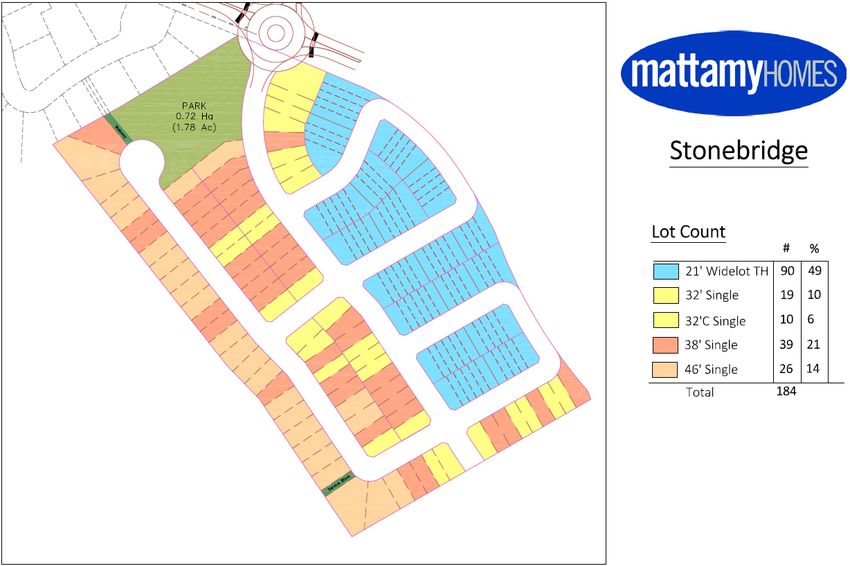
3.0                                                                                                     5
PROPOSED DEVELOPMENT
Mattamy Homes proposes to subdivide the subject lands to enable the development of a residential community
known as Stonebridge Phase 16. The concept plan for the community is illustrated as Figure 3 below.

Figure 3: Concept Plan for Stonebridge Phase 16

The subdivision includes a range of housing types and densities, including detached homes and townhouses.
Table 1 summarizes the breakdown of each dwelling type and model.

 Planning Rationale                                    Mattamy Homes                       September 2020
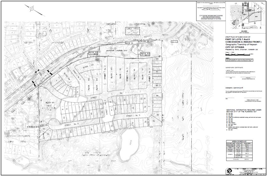
6

Table 1: Breakdown of Proposed Dwelling Units

Unit Type                                          Total Units                      Percentage of Total
Detached                                                94                                   51%
9.7-Metre (32-Foot) Single                              29                                   16%
11.6-Metre (38-Foot) Single                             39                                   21%
14-Metre (46-Foot) Single                               26                                   14%
Townhouses                                              90                                   49%
Widelot Townhouse                                       90                                   49%
Total                                                  184                                  100%

3.1     Parkland
A park totaling 0.72 hectares is reserved for a Neighbourhood Park at the northern portion of the subject lands
(Block 105). The park is located directly west of the main access point to the subdivision from Longfields Drive.
The Neighbourhood Park will have limited frontage along Longfields Drive to the northeast, on Street 1 to the
east, Street 3 to the west, and on the Uniform subdivision to the north. A pedestrian connection along the
northern property line of the proposed subdivision will provide access to the park space for the residents of the
adjacent Uniform subdivision.

The City of Ottawa Parkland Dedication By-law (2009-95) requires the dedication of 1 hectare of parkland for
every 300 units (for densities of 18 dwellings per net hectare or more). At 184 units, a total of 0.61 hectares of
parkland are required. The proposed parkland represents a modest over-dedication of 0.11 hectares of parkland,
accounting for the parkland requirements for the Uniform subdivision to the north.

The Draft Plan of Subdivision is shown as Figure 4 below.

3.2     Streets
As established in the City of Ottawa Transportation Master Plan (2013), the portion of Longfields Drive between
Cambrian Road and Prince of Wales Drive is anticipated to be widened from two (2) to four (4) lanes. The road
widening will also result in a roundabout located at the entrance to the subdivision. The road widening is
projected to occur between 2020-2025, which will ameliorate the increased traffic demand anticipated from
surrounding development in the near future.

The submitted Concept Plan and Draft Plan of Subdivision both reflect the ultimate condition of Longfields Drive
following completion of the road widening. The proposed street network is therefore designed to integrate with
the existing and anticipated surrounding street network, while providing connectivity throughout the proposed
subdivision.

A southern extension of existing Kilspindie Ridge is proposed at the northeast corner of the subject lands
providing access to the subdivision. The proposed roundabout at the access point will improve efficiency along
Longfields Drive and calm traffic near the subdivision.

The street network is proposed to terminate at a cul-de-sac adjacent to the Neighbourhood Park. Window
streets along the eastern edge of the subdivision provide a buffer between the residential properties and

 Planning Rationale                                         Mattamy Homes              September 2020
7

Longfields Drive, reducing instances of rear-lotting along the edge of the community. The Transportation Impact
Assessment recommends that sidewalks be located on one side of the proposed streets.

Figure 4: Draft Plan of Subdivision

A road allowance is proposed to be reserved at the southern edge of the subdivision. In the event that the urban
boundary is expanded, the proposed street network provides an extension to the southern edge of the
subdivision. The proposed street configuration is intended to direct traffic to the Longfields Drive arterial road
and restrict any traffic within the existing Stonebridge community.

The proposed street widths are summarized in Table 2 below:

Table 2: Street Hierarchy

Street Type                                Proposed Street Width
Local Streets                                        18 m
Local Streets- Window Streets                       14.5 m

 Planning Rationale                                         Mattamy Homes              September 2020
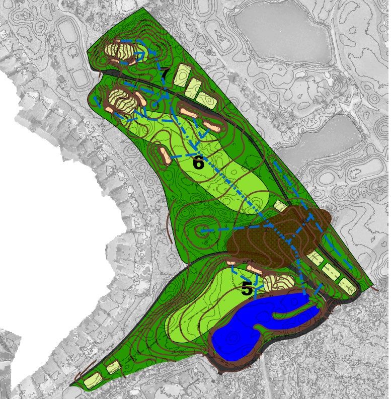
8

3.3     Stormwater Management Facility
A stormwater management pond to service the development is proposed to be located west of the development
on the existing golf course. In the future, the pond will be owned and maintained by the City of Ottawa.

3.4     Potential Golf Course Plan
As mentioned above, the proposed plan of subdivision will ultimately result in the reconfiguration of existing
holes 5, 6, 7, and 8 in the golf course (Figure 5). The reconfiguration is intended to retain the playability of the
hole, while recognizing the new dwellings.

Figure 5: Concept Plan of Holes 5-7

 Planning Rationale                                          Mattamy Homes                 September 2020
4.0                                                                                                                 9
POLICY AND REGULATORY CONTEXT
4.1       Provincial Policy Statement
The Provincial Policy Statement (PPS) was issued under Section 3 of the Planning Act in May 2020. It provides
direction on matters of provincial interest related to land use planning and development. The PPS also
recognizes that local context is important and that it is to be read as a whole.

The PPS policies require that growth and development be focused within settlement areas, and must form
efficient development patterns that optimize the use of land, resources and public investment in infrastructure
and public service facilities. These land use patterns promote a mix of housing, including affordable housing,
employment, recreation, parks and open space and transportation choices that increase the use of active
transportation and transit before other modes of travel.

They also support the financial well being of the Province and municipalities over the long term and minimize the
undesirable effects of development, including impacts on air, water and other resources.

The PPS also emphasizes the need to establish development standards for residential intensification,
redevelopment, and new residential development which minimize the cost of housing and facilitate compact
form, while maintaining appropriate levels of public health and safety.

The PPS defines “intensification” as: the development of a property, site or area at a higher density than
currently exists through: a) redevelopment, including the reuse of brownfield sites; b) the development of vacant
and/or underutilized lots within previously developed areas; c) infill development; and d) the expansion or
conversion of existing buildings. Lastly, the PPS also recognizes and supports the wise use and management of
natural heritage, water, archaeological, cultural heritage resources over the long term and the importance of
protecting the health and safety of the population by directing development away from natural and man-made
hazards.

The Planning Act requires that decisions affecting planning matters “shall be consistent with” policy statements
issued under the Act.

4.1.1 Proposed Development and Consistency with the PPS
The proposed development and the submitted Zoning By-law Amendment and Plan of Subdivision applications
conform to PPS policies. Key policies are highlighted below:

Healthy, liveable and safe communities are sustained by:
      /   Promoting efficient development and land use patterns which sustain the financial well-being of the
          Province and municipalities over the long term;
      /   Accommodating an appropriate affordable and market-based range and mix of residential types,
          employment, institutional, recreation, park and open space, and other uses to meet long-term needs;
      /   Promoting the integration of land use planning, growth management, transit-supportive development,
          intensification and infrastructure planning to achieve cost-effective development patterns, optimization of
          transit investments, and standards to minimize land consumption and servicing costs; and
      /   Ensuring that necessary infrastructure and public service facilities are or will be available to meet current
          and projected needs.

Land use patterns within settlement areas shall be based on:
      /   Densities and a mix of land uses which:

 Planning Rationale                                           Mattamy Homes                          September 2020
10
o Efficiently use land and resources; and
o Are appropriate for, and efficiently use, the infrastructure and public service facilities which are
planned or available, and avoid the need for their unjustified and / or uneconomical expansion.
Planning authorities must:
/ Provide for an appropriate range and mix of housing types and densities to meet projected market-based
and affordable housing needs of current and future residents;
/ Direct the development of new housing towards locations where appropriate levels of infrastructure and
public service facilities are or will be available to support current and projected needs;
/ Promote densities for new housing which efficiently use land, resources, infrastructure and public
service facilities, and support the use of active transportation and transit in areas where it exists or is to
be developed; and
/ Establish development standards for residential intensification, redevelopment, and new residential
development which minimize the cost of housing and facilitate compact form, while maintaining
appropriate levels of public health and safety.
Healthy, active communities should be promoted by:
/ Planning public streets, spaces and facilities to be safe, meet the needs of pedestrians, foster social
interaction and facilitate active transportation and community connectivity; and
/ Planning and providing for a full range and equitable distribution of publicly-accessible built and natural
settings for recreation, including facilities, parklands, public spaces, open space areas, trails and
linkages, and, where practical, water-based resources.
The subject lands represent developable lands within an established Settlement Area with available and
adequate infrastructure and public service facilities that can accommodate additional housing needs. The
existing golf course use does not facilitate public access onto lands with natural features, nor is it supportive of
promoting transit ridership. In contrast to the existing land use, the proposal is more consistent with the policies
of the PPS than the existing land use.
The proposed development includes a range of housing types within the settlement area boundary, as
well as appropriate infrastructure and public service facilities to serve the new community. The plan
promotes the intensification of under-utilized spaces by proposing new residential development in a form
that is compatible with the surrounding existing settlement areas. The proposed Plan of Subdivision and
Zoning By-law Amendment is consistent with the policies of the Provincial Policy Statement (2020).
4.2 City of Ottawa Official Plan (2003, as amended)
In a pre-application consultation meeting with the City of Ottawa on December 13th, 2017, and in accordance with
previous direction, it was confirmed that the subject lands are located within the Urban Boundary and designated
General Urban Area. Consequently, an Official Plan Amendment (OPA) is not required in support of the planning
applications. The proposed residential use, as discussed below, complies with the policies of the General Urban
Area designation of the Official Plan.
The General Urban Area designation permits all types and densities of housing, as well as employment, retail
uses, service, industrial, cultural, leisure, greenspace, entertainment and institutional uses. The designation
permits the development of a full range and choice of housing types to meet the needs of all ages, incomes and
Planning Rationale Mattamy Homes September 202011
life circumstances. The purpose of this designation is to facilitate the development of complete and sustainable
communities.
The City supports infill development within the General Urban Area where it will complement the existing pattern
and scale of development and planned function of the area. The predominant form of development and
intensification will be semi-detached and other ground-oriented multiple-unit housing. When considering a
proposal for residential intensification through infill or redevelopment in the General Urban Area, the City will:
/ Assess the compatibility of new development as it relates to existing community character so that it
enhances and builds upon desirable established patterns of built form and open spaces; and
/ Consider its contribution to the maintenance and achievement of a balance of housing types and
tenures to provide a full range of housing for a variety of demographic profiles throughout the General
Urban Area.
Section 2.2.2 contains policies for Managing Intensification Within the Urban Area. Policy 1 defines “residential
intensification” as the development of a property, building or area that results in a net increase in residential units
or accommodation and includes, among others:
/ Redevelopment;
/ The development of vacant or underutilized lots within previously developed areas, being defined as
adjacent areas that were developed four or more years prior to new intensification;
/ Infill development.
Policy 22 states that the City supports compatible intensification within the urban boundary, including areas
designated General Urban Area. Intensification that is compatible with the surrounding context will be supported
in a range of circumstances, including on sites that are no longer viable for the purpose for which they were
originally used or intended.
The evaluation of development applications, studies, other plans and public works undertaken by the City in the
General Urban Area will be in accordance with Section 2.5.1 and Section 4.11 of the Official Plan. Section 2.5.1
of the Official Plan contains a set of Design Objectives and Principles for development across the City. The
proposed development meets the objectives as follows:
/ To enhance the sense of community by creating and maintaining places with their own distinct
identity
The subdivision continues the built form character and identity of adjacent communities, including
housing forms, densities, land uses, and patterns of open space.
/ To define quality public and private spaces through development
The subdivision is designed to feature a connected network of streets and a park that provide areas for
gathering, socializing, recreation, and other activities.
/ To create places that are safe, accessible, and are easy to get to, and move through
The proposed street network is designed to integrate with the surrounding street pattern, creating a
logical configuration that facilitates movement and connectivity. The proposed roundabout is also
designed to create a safer environment for motorists, cyclists and pedestrians alike. Front and side
yards abut or face the proposed park block to ensure passive surveillance of the public space.
/ To ensure that new development respects the character of existing areas
Planning Rationale Mattamy Homes September 202012
The proposed subdivision continues the built form and land use characteristics of surrounding
communities. The road network integrates with the surrounding network, improving connectivity for all
modes of transportation. The Stonebridge Community is characterized by the golf course, that will be
maintained as an 18-hole course.
/ To consider adaptability and diversity by creating places that can adapt and evolve easily over
time and that are characterized by variety and choice
The subdivision contains a variety of housing types that permit a range of demographics and incomes to
live in the community. The surrounding golf course will be maintained as an 18-hole course.
/ To understand and respect natural processes and features in development design
The proposed stormwater management system, including the stormwater management pond, will
respond to the natural topography of the subject lands and the quality of the soils.
/ To maximize energy efficiency and promote sustainable design to reduce the resource
consumption, energy use, and carbon footprint of the built environment
The proposed zoning permits alternative development standards that reduce land consumption and
permits increased gross densities.
Section 4.11 contains policies intended to achieve good urban design and compatibility. The policies generally
pertain to building design, which is not addressed in a Plan of Subdivision application. The proposed Zoning By-
law Amendment permits residential buildings of a character consistent with surrounding neighbourhoods.
Policy 4.7.8 of the Official Plan requires an Environmental Impact Statement for development within 30 metres of
a natural heritage system feature in the urban area. An Environmental Impact Statement has been submitted with
this application, which confirms that negative impacts to the listed Species at Risk (SAR) or other natural
heritage features are not anticipated as a result of the proposed plan of subdivision. The EIS highlights that
mitigations for Barn Swallows may be required.
The proposed Plan of Subdivision and Zoning By-law Amendment applications conform to the policies of
the Official Plan.
4.3 New City of Ottawa Official Plan
The City of Ottawa is currently undertaking the preparation of a new Official Plan, which is projected to be
adopted by Council in Spring 2021. The “Ottawa Next: Beyond 2036” report outlined potential future scenarios
based on interpretations of major and emerging environmental, technological, economic, and social trends and
drivers, as detailed in nine discussion papers.
The City has established its “Five Big Moves” to inform future policy directions. The most significant policy
proposals include:
/ Growth: Achieve, by the end of its planning period, more growth by intensification than by greenfield
development. This growth will provide a variety of affordable housing options for residents.
/ Mobility: By 2046, the majority of trips in the City of Ottawa will be made by sustainable transportation.
/ Urban Design: Improve our sophistication in urban and community design, and put this knowledge to
the service of good urbanism at all scales, from the largest to the very small.
/ Resiliency: Embed public health, environmental, climate and energy resiliency into the framework of our
planning policies.
/ Economy: Embed economic development into the framework of our planning policies.
Planning Rationale Mattamy Homes September 202013
The proposed development is consistent with the preliminary policy directions established in the Five Big
Moves. The proposal represents intensification in the urban area, contributing to the goals of the
“Growth” direction.
4.4 Urban Design Guidelines for Greenfield Neighbourhoods
The City of Ottawa Council approved a set of Urban Design Guidelines for Greenfield Neighbourhoods in
September 2007. The guidelines outline the City’s expectations during the development review process for
greenfield neighbourhoods. The proposal meets several of the guidelines, including:
/ Considers soils, landforms, natural and cultural features, habitats, watercourses and climate in the
design of the community;
/ Proposes a park at the northern portion of the development;
/ Proposes the connection of new streets to existing streets in adjacent developments and plans for future
connections to land that has yet to be developed;
/ Lays out local street patterns so that development blocks are easily walkable;
/ Locates the Neighbourhood Park along a local street, and proposes a shape appropriate for
programming;
/ Proposed window streets allow for a buffer between residential properties and Longfields Drive; and
/ Proposed zoning allows residential buildings to be located close to the property line.
4.5 Comprehensive Zoning By-law 2008-250
As illustrated on Figure 10, the subject lands are currently zoned Parks and Open Space, Subzone A (O1A) in the
Comprehensive Zoning By-law (2008-250). The Parks and Open Space Zone is intended to:
/ Permit parks, open space and related and compatible uses to locate in areas designated as General
Urban Area, General Rural Area, Major Open Space, Mixed-Use Centre, Village, Greenbelt Rural and
Central Area as well as in Major Recreational Pathway areas and along River Corridors as identified in
the Official Plan, and
/ Ensure that the range of permitted uses and applicable regulations is in keeping with the low scale, low
intensity open space nature of these lands.
The O1A Subzone is intended to permit a golf course use in addition to other permitted uses.
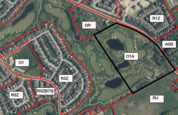
Planning Rationale Mattamy Homes September 202014 Figure 6: Zoning Map As the subject lands are entirely zoned O1A, the existing zoning is inappropriate for the proposed subdivision. As such, the Zoning By-law Amendment application seeks to rezone the portion of the subdivision which will contain the proposed Neighbourhood Park to Parks and Open Space (O1) and rezone the proposed residential portion of the subject lands to Residential Third Density Subzone YY (R3YY). Figure 7 identifies the location of the proposed zones. Full details for the R3YY zone are summarized in Appendix A to the Planning Rationale. Planning Rationale Mattamy Homes September 2020
15

Figure 7: Proposed Zoning

 Planning Rationale         Mattamy Homes   September 2020
5.0                                                                                                           16
SUPPORTING STUDIES
5.1     Assessment of Phase 1 Environmental Site Assessment
Paterson Group conducted a Phase 1 Environmental Site Assessment which provided a research of the past and
current uses of the site, as well as an identification of any environmental concerns which may impact the subject
lands.

Based on the findings, the report concluded that selenium was identified above the MOECC standard in two of
the four samples. Although its source is unknown, it is possible that the concentrations of selenium are naturally
occurring. Additional soil testing is recommended in order to further evaluate the presence of selenium.

Beyond this finding, the report cites no further concerns regarding the appropriateness of the soil for the
proposed development, and notes that a Phase II ESA is not required.

5.2     Adequacy of Public Servicing Report
IBI Group prepared an Adequacy of Public Servicing Report, which provided an assessment of availability of
servicing throughout the subject lands. More specifically, the study analyzed water distribution, wastewater
disposal, stormwater management, grading and sediment and erosion control.

Based on the findings, the report concludes that water, wastewater and stormwater systems required to
accommodate the proposed plan of subdivision are available.

5.3     Assessment of Transportation Impact Assessment
A Transportation Impact Assessment was prepared by Parsons. The report reviews existing and forecasted
transportation conditions in the surrounding area, including multiple modes of transportation. The report
concludes that the proposed development is recommended from a transportation perspective.

5.4     Roadway Traffic Noise Feasibility Assessment
A Roadway Traffic Noise Feasibility Assessment was prepared by Gradient Wind Engineering. Based on the
findings, the report concludes that the highest roadway traffic noise levels will occur along Longfields Drive.
Outdoor living areas with exposure to the noise sources within 100 metres of Longfields Drive may therefore
require noise control measures.

5.5     Environmental Impact Assessment
An Environmental Impact Statement (EIS) was prepared by Kilgour & Associates. Based on the findings, the
report concludes that negative impacts to the listed Species at Risk (SAR) or other natural heritage features are
not anticipated as a result of the proposed plan of subdivision. The EIS highlights that mitigations for Barn
Swallows may be required. This will be confirmed through additional site bird surveys.

 Planning Rationale                                        Mattamy Homes                         September 2020
6.0                                                                                                     17
CONCLUSIONS
The proposed Plan of Subdivision and Zoning By-law Amendment applications meet the policies of the
Provincial Policy Statement and City of Ottawa Official Plan. Additionally, the subdivision meets several Urban
Design Guidelines for Greenfield Neighbourhoods. The proposed development is also consistent with the criteria
for subdivisions in Section 51(24) of the Planning Act.

In our professional opinion, the draft Plan of Subdivision and the Zoning By-law Amendment applications are
appropriate for the lands and are in the public interest.

Miguel Tremblay, MCIP RPP                               Jaime Posen, MCIP RPP
Partner                                                 Senior Planner

 Planning Rationale                                     Mattamy Homes                        September 2020
APPENDIX A: PROPOSED ZONING DETAILS

Residential Third Density Subzone YY, Exception 1627 (R3YY [1627])

A - General:

    /   Where access to a lot is provided by a street with sidewalks provided under the requirements of the plan
        of subdivision, the front yard setback for an attached garage will be measured from the garage to the
        nearest edge of the sidewalk, for a minimum setback of 6m from the back edge of the sidewalk
    /   The front wall of an attached garage may not be located more than 2m closer to the front lot line than
        either the front wall of the main building or the leading edge of a roofed porch
    /   Minimum density is 29 units per net hectare;
    /   The minimum distance between a driveway and an intersection of two street lines is 6m measured at the
        street line
    /   The minimum distance between a driveway for a townhouse
        dwelling on a public lane and an intersection of two street lines is 3.5m measured at the street line
    /   Outdoor amenity areas is permitted on top of garages in townhouse dwellings located on rear lanes
    /   More than one detached dwelling is permitted on an existing lot of record for the purpose of serving as a
        model home provided a draft Plan of Subdivision has been approved for the lot of record

For detached dwellings:

    /   Minimum lot area is 220 m2
    /   Minimum lot width is 8.8 m
    /   Minimum front yard setback is 3m for the principal building and attached garage
    /   Minimum combined interior side yard setback is 1.8m with a minimum of 0.6m on one side
    /   Minimum rear yard for a corner lot is 0.6m
    /   Minimum corner side yard is 2.5m
    /   Maximum lot coverage is 55%

For semi-detached dwellings:

    /   Minimum lot area is 137m²
    /   Minimum lot width is 5.5m
    /   Minimum front yard setback is 3m for the principle building and attached garage
    /   Minimum corner side yard is 2.5m
    /   Minimum rear yard setback for a townhouse dwelling and garage on a rear lane is 0m
    /   Maximum lot coverage is 65%
    /   Maximum building height is 12m

For back-to-back and/or townhouse dwellings:

    /   Minimum lot area is 81m²
    /   Minimum lot width is 4m
    /   Minimum front yard setback is 3m for the principal building and attached garage
    /   Minimum front yard setback is 3m for the principal building and attached garage
    /   Minimum rear yard setback for a townhouse dwelling and garage on a rear lane is 0m
    /   Minimum corner side yard is 2.5m
    /   Minimum interior side yard setback is 1.5m and 0m on the common lot line of attached buildings
    /   Maximum building height is 14m

 Planning Rationale                                      Mattamy Homes                         September 2020
19
B – General:
/ When access to a lot is provided by a public rear lane a minimum of 8.5m wide, and that lot also abuts a
public park, the public park frontage shall be considered to be a “frontage on a public street” for
interpretation of the provisions of this zoning by-law
/ A sill, belt course, cornices, eaves, gutters, chimneys, chimney box, fireplace box, overhangs or pilasters
may project 1m into the required front and corner side yard and 1m, but no closer than 0.2m, into the
interior side yard
/ Balconies may project 2m, but no closer than 1m from the property line and no closer than 0m from a
property line abutting a sight triangle, into the front and corner side yard
/ Open, roofed or unroofed porches and entrance features not exceeding one storey in height may project
2m, but no closer than 1m from the property line and no closer than 0m from a property line abutting a
sight triangle, into the front and corner side yard, and 1m into a rear yard
/ A deck may project 2m, but no closer than 1m from the property line, into a front and corner side yard; in
a rear and interior side yard a deck may project to within 0.3m of a lot line and an additional 0.3m
setback from every 0.3m or portion thereof that is constructed above finished grade
/ Steps attached to a porch may project 2.5m, but no closer than 0.5m from property line and no closer
than 0m from a property line abutting a sight triangle, into a front and corner side yard
/ Air conditioning units may project 1m into a corner and interior side yard and 2m into a rear yard, but no
closer than 0.2m to the property line
/ Corner sight triangles shall have the following distances:
o 10 metre triangles when involving arterial roads
o 5 metres when involving only local roads
o 3 metres when involving a public lane
/ In the case of a home-based business operating within a townhouse or semi-detached dwelling, the
required parking space is only required if the business involves an outside employee
/ No more than 60% of the area of any front yard or corner side yard may be used as a driveway or
parking space
/ Exterior parking spaces will have a minimum length of 5.5m and a minimum width of 2.7m
/ Blocks of townhouse dwellings that are attached along the rear and side walls shall be limited to sixteen
attached dwelling units within each block
/ 0.0 metre setback required from the lot line at a corner lot line
Parks and Open Space Zone
o Minimum Lot Width: No minimum
o Minimum Lot Area: No minimum
o Minimum Front Yard Setback: 7.5 m
o Minimum Corner Side Yard Setback: 7.5 m
o Minimum Rear Yard Setback: 7.5 m
o Minimum Interior Side Yard Setback: 7.5 m
o Maximum Building Height: 11 m
o Maximum Lot Coverage (%): 20
Planning Rationale Mattamy Homes September 2020You can also read