PLANNING REPORT FOR A - BALLYCULLEN LIMITED PARTNERSHIP - Ballycullen SHD
←
→
Page content transcription
If your browser does not render page correctly, please read the page content below
PLANNING REPORT

                                          FOR A

STRATEGIC HOUSING DEVELOPMENT AT WOODTOWN,
                                 BALLYCULLEN,
                                    DUBLIN 16

                                    PREPARED BY

                                   ON BEHALF OF

              BALLYCULLEN LIMITED PARTNERSHIP

                                       JUNE 2021

                                               1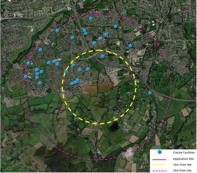
INTRODUCTION
On behalf of the applicant, Ballycullen Limited Partnership., 15 Herbert Street, Dublin 2, this planning
report accompanies a planning application to An Bord Pleanála in relation to a proposed Strategic
Housing Development at Woodtown, Ballycullen, Dublin 16, in accordance with Section 4 of the
Planning and Development (Housing) and Residential Tenancies Act 2016.

The application has been prepared by a multidisciplinary team on behalf of Ballycullen Limited
Partnership as set out in the table below:
    - MCG Planning Limited
    - Mc Crossan O’ Rourke Manning Architects
    - Pat O’ Gorman Consulting Engineers
    - Ronan Mc Diarmada & Associates Landscape Architects
    - NRB Consulting Engineers
    - 3D Design Bureau
    - Whitehill Environmental
    - Wildlife Surveys
    - The Tree File
    - Traynor Environmental
    - IAC Archaeology

The proposed residential development on the subject lands will comprise 329 no. residential units, a
crèche, parking, public open spaces, roads, and services.

 Development Proposal                Statistics
 No. of residential units            329 no. units comprising:
                                        - 57 no. 1 bed apartments
                                        - 132 no. 2 bed apartments/duplexes
                                        - 85 no. 3 bed houses
                                        - 53 no. 4 bed houses
                                        - 2 no. 5 bed houses

 Community Facilities                Creche c.295.5 sqm
 Site Area                           Gross Site Area: c. 10.41 ha
                                     Net Site Area (Excluding Ballycullen Park): c.7.72 ha
 Net Residential Density             Excluding Ballycullen Park: 43 uph
                                     Excluding Ballycullen Park + Residential Pocket Parks : 47 uph
 Building height                     2 to 5 storeys in height

 Dual Aspect                         100% of houses
                                     53% of apartments/duplexes
 Apartment Communal Open             c.2,770 sqm (1,213 sq.m required)
 Space
 Public Open Space                   c.34,091 sq.m (32.7%) (Ballycullen Park & Residential Pocket
                                     Parks)
 Car Parking                         2 car parking spaces per housing unit.

                                                                                                       2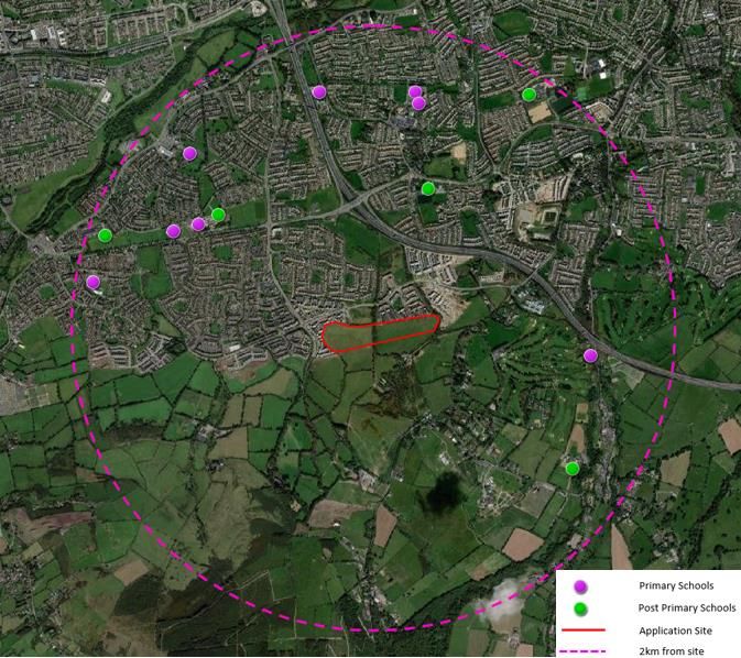
224 no. spaces for apartments/duplexes. This equate to 1.18
no. car parking spaces per apartment/duplex (incl visitor).
11 no. spaces to serve the creche.
Also 4 additional visitor spaces for Stocking Wood Drive as a
result of revisions to the existing hammerhead to provide the
second vehicular access to the proposed development.
Plot Ratio 0.33
Site Coverage 18%
Whilst every effort has been made to ensure complete consistency across all reports and drawings
accompanying this planning application there may be instances where typographical errors and/or
minor inconsistencies do occur. These are unlikely to have any material impact on the ability of An
Bord Pleanála to carry out a thorough assessment of the proposal.
Furthermore, to avoid any confusion, we note that the red line boundary of the application site is as
shown on the Site Location Map and the Site Layout Plan prepared by MCORM Architects and is done
so in full accordance with the Planning & Development Regulations, 2001 to 2020. All other maps and
drawings contained within sub-consultants reports submitted with the application are for illustrative
purposes only related to said reports.
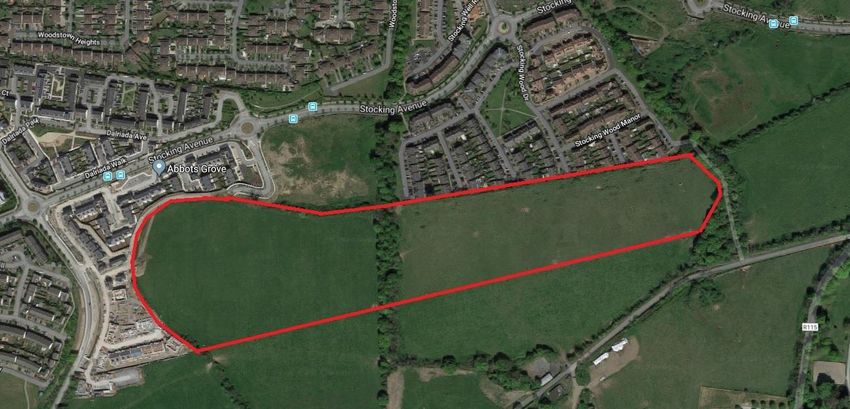
SITE LOCATION AND CONTEXT
The subject lands extend to c.10.41 ha and are located at the foothills of the Dublin Mountains in an
area known as Ballycullen.
The lands are located at the periphery of the urban area of South County Dublin with lands to the
south forming the rural hinterland of the county and the foothills of the Dublin Mountains.
It is south/south-east of the M50 motorway and Stocking Avenue. Stocking Lane is further to the
south and Ballycullen Road is to the west.
The Stocking Wood residential estate (comprising Stocking Wood Copse/Green/Hall/
Drive/Walk/Manor) is located to north-east of the site. The Abbot’s Grove residential development
(currently under construction) is located to the northwest and west. A vacant site also zoned
residential is located immediately north of the site between Stocking Wood and Abbot’s Grove.
3
Existing road access from the site to Stocking Avenue is available via the road built to also serve
Abbot’s Grove.

The site has a steep topography in places particularly to the east. The gradient difference from north
to south across the site is approximately 14m in places.

A band of woodland/double ditch runs north –south through the centre of the site creating a natural
break and two potential development areas to the east and west. A further band of mature trees and
hedgerow form the eastern boundary.

Lands further east are controlled by Ardstone and have extant permissions for residential with
development underway.

The boundary with the Stocking Wood estate to the north comprises timber fencing and concrete
posts. The original tree/hedgerow boundary with Abbots Grove to the west/northwest has been
largely removed as part of that development.

A long fence c.675m in length marks the southern boundary of the site with agricultural lands further
south.

Transport

The Ballycullen area is well served in terms of public transport and local services including schools and
retail within walking distance of the proposed development. The 15B Dublin Bus services (with stops
within 100m of the site) operates between Stocking Lane and the City Centre with 63 each way
services on weekdays. The more frequent 15 service operates from Ballycullen road through the city
centre to Clongriffin with stops within 400m of the site.

                                                                                                        4
Schools
There are eight primary schools and five post-primary schools located within a 2km radius of the
subject site.
Enrolment no. Primary Schools indicated by purple dots
1 Edmonstown National School
2 Firhouse Educate Together National School
3 Gaelscoil Na Giúise
4 Scoil Treasa Firhouse
5 Holy Rosary Primary School
6 Gaelscoil Chnoc Liamhna
7 St Colmcille Senior National School
8 St Colmcille Junior National School
Post-Primary Schools by green dots
1 Rockbrook Park School
2 St Colmcille Community School
3 Firhouse Educate Together Secondary School
4 Firhouse Community College
5 Sancta Maria College
5Childcare Facilities
An assessment of the information provided by Pobal and South Dublin County Childcare Committee
identified 30 no. existing childcare facilities within the area, shown in below in figure 10 below and
listed in the table below. 8 no. of these facilities are within 1km of the site.
Details of the provision of childcare facilities in the area is set out in below and in Chapter 4 of the
EIAR submitted with this application.
Childcare Facility Within 1km Radius Location
1. Chuckleberries Dalriada 1 Dalriada Hall, Dalriada
2. Ballycullen Montessori 69 Hunters Walk, Ballycullen, Dublin 24
3. Chuckleberries - Hunterswood 55 Hunterswalk, Hunterswood
4. Pebbles Playschool 13 Woodstown Walk, Knocklyon, Dublin 14
5. Wendys House Montessori 2 Woodstown Park, Ballycullen Rd
6. The Learning Curve Unit 12 - 15, Woodstown Village Shopping
Centre, Knocklyon, Dublin 16
7. The Childrens House Montessori School 52 Rathlyon Grove
8. Let's Play Preschool 5 Orlagh Way, Knocklyon
Childcare Facility Within 2km Radius Location
9. Twinkle Stars Preschool 1 Wooddale Green, Firhouse
10. Naíonra Na Giúise Naíonra Na Giúise, Ballycullen Drive,
Firhouse
11. Primary Pals Firhouse Firhouse Community Centre, Ballycullen
Drive, Firhouse
12. Killakee Montessori & Creche 11 Killakee Court
13. Small Steps Together Firhouse Community College, Firhouse Road
614. Discoveries Creche & Montessori School Ltd Old Court Centre
15. Lily's Before and Afterschool Childcare The Park Community Centre, Parklands
Road, Firhouse
16. Tickles Childcare 38 Old Court Ave, Firhouse, Tallaght, Dublin
24
17. Mini Marvels Montessori School 16 Ferncourt Green, 16 Ferncourt Green,
Old Court Road Firhouse, Dublin 24
18. Ferncourt Preschool 12 Ferncourt Close, Firhouse
19. First Rung Early Education 14 Old Court Manor, Old Court Road
20. Firhouse Montessori School 38 Woodlawn Park Drive, Firhouse Road
21. Chuckleberries - Tree Tops 147 Monalea Grove
22. Naíonra Cnoc Liamhna Knocklyon Scouts Den, Old Knocklyon Road
23. Knocklyon Lodge & Creche Montessori Old Knocklyon Road, Knocklyon
24. Eager Beavers Montessori 3 Beverly Downs
25. Little Penguins 17 Beverly Grove
26. Lyons Den Knocklyon Youth and Community Centre,
Idrone Avenue, Knocklyon
27. Coolkidz Montessori 51 Coolamber Park, Knocklyon Road
28. The Lodge Montessori School 1 Templeroan Lodge, Rathfarnham, Dublin
16
29. Edmonstown National School Edmondstown Road, Rathfarnham
30. Delaford Montessori 40 Delaford Drive, Knocklyon, Dublin 16
PLANNING HISTORY
The site has been subject to a number of previous planning applications in 2006/7 for significant
residential development. A summary table is provided below.
An initial application for nearly 400 residential units was refused by ABP in March 2007 on the basis
that the proposed development (which included 3 and 4 storey apartment blocks) would be visually
obtrusive given the location proximate to the Dublin Mountains high amenity area.
A subsequent revised scheme revised to 386 units (192 houses and 194 apartments) was granted by
the Board. Despite a recommendation to refuse from the Board Inspector the Board granted
permission based on the following rationale:
“Having regard to the A1 zoning of the site within these Action Area lands on the urban fringe
adjoining the foothills of the Dublin Mountains and to the emerging pattern of development
in the area, it is considered that, subject to compliance with the conditions set out below, the
proposed development has been appropriately designed for this site, would not seriously injure
the amenities of the area or property in the vicinity and would be acceptable in terms of traffic
7safety and convenience. The proposed development would, therefore, be in accordance with
the proper planning and sustainable development of the area.”
The development was never commenced. An application to extend the permission was lodged in
August 2013. However, the extension was refused due to the development not being consistent with
the then 2010-2016 County Development Plan (in relation to SuDS) and the 2009 national Floodrisk
Guidelines.
It is also important to note that this decision to refuse Extension of Duration was made prior to the
adoption of the 2014 Ballycullen Oldcourt Local Area Plan, which now prescribes much lower densities
for this site.
Ref. Applicant Description Decision Date
Permission Refused for the
following reason:
It is the policy of the planning
authority, as set out in the current
Development Plan for the area,
when considering new housing
development in this area, to have
due regard to the high amenity
SD06A/0611 396 no. residential value and proximity to the Dublin
Ballycullen units (245 houses and Mountains. Having regard to the
Limited 151 apartments), all prominent, elevated location of
ABP Ref. Partnership ancillary site the site and to the layout 30/03/07
PL06S.219949 development, proposed, which entails an undue
landscaping, and degree of excavation into the
boundary treatment mountain slope with consequent
works. large scale retaining structures, it
is considered that the proposed
development would be excessively
obtrusive and would seriously
injure the visual amenities of the
area. The proposed development
would, therefore, be contrary to
the proper planning and
sustainable development of the
area.
Permission Granted subject to 23
conditions including:
2. Phase 1, 249 number units and
the crèche and community centre
shall be constructed at the
western side of the site and the
remaining units at the eastern
side of the site shall be
constructed under Phase 2.
3. The public open space between
the eastern and western sections
SD07A/1035 Ballycullen 386 no. residential of the development shall be
Limited units (192 houses and completed before the 08/01/09
Partnership 194 apartments), commencement of Phase 2 of the
PL06S.229509 creche, community development. Open spaces shown
8facility, car parking, between clusters 1, 2, 3, and 4
bicycle parking, storage shall be completed prior to
and bin storage and site occupation of adjoining units.
works. 4. Unit number 249 shall be
omitted, and this area shall be
incorporated into the adjoining
open space. Prior to
commencement of development,
a revised layout in this regard shall
be submitted for the written
agreement of the planning
authority.
Extension of Duration Refused for
the following 2 reasons:
• The development does not
comply with Policy WD6 of
Extension of Duration the 2010-16 County
Ballycullen Application for Development Plan in relation
SD07A/1035/EP Limited SD07A/1035 to incorporation of SuDS. 11/10/13
Partnership permission.
• The permission is not
consistent with the
Ministerial Guidelines “The
Planning System and Flood
Risk Guidelines” (2009)
PREVIOUS SHD PRE-PLANNING CONSULTATION
In March 2018, a Tri-partite meeting under Section 5 of the Planning & Development (Housing) and
Residential Tenancies Act, 2016, was held with ABP with SDCC in relation to a previous SHD proposal
on this site (Ref. ABP-300906-18).
The previous proposal was for a smaller residential development comprising 181 houses (10 no. 2-
bed; 93 no. 3-bed; 72 no. 4-bed and 6 no. 5-bed). A crèche was also proposed along with car and
bicycle parking, landscaping, public open spaces, and all associated site development works and
services provision.
The Board’s Opinion dated 12th April 2018 raised a number of issues in relation to the then proposed
development and also requested additional information to be submitted with any future application.
On foot of the Opinion, the scheme was revised to address the issues raised. A summary of the issues
raised and the applicant’s response, having regard to the current application is outlined below.
9A detailed description of the phasing of key infrastructure in the area is outlined in the Statement
of Consistency and the Material Contravention Statement.
• The proposed development provides for two road accesses; (1) via the existing road that also
serves the Abbots Grove Avenue from the Stocking Avenue roundabout; and (2) from Stocking
Wood Drive.
• Permeability is optimised with footpaths extended to the boundaries with Abbot’s Grove to the
west, Stocking Wood estate to the north-east and the Ardstone development to the east.
• Compliance with the 12 criteria of the Urban Design Manual for the current scheme is outlined
in the MCORM Architects Design Report and the Statement of Consistency.
10• The previous proposal of 181 units had a net residential density of 21 units per ha.
• The current proposal for 329 units equates to a net density of 43 uph or 47 uph when the
residential pocket parks are excluded from the net site area. This is considered in
accordance with national policy and is outlined further in the Statement of Consistency and
the Response to the Board’s Opinion report.
• A variety of pocket, public and communal open spaces are proposed across the development
which will ensure that all residents will be proximate to open space and will avail of a variety of
recreational options.
• The spaces are detailed in the Site Layout Plan, Landscape Masterplan, and associated
documentation.
• The proposed development measures in excess of 10ha and therefore falls within one of
the categories of development specified in Schedule 5 of the Planning and Development
Regulations 2001, as amended. As a result the application is accompanied by an
Environmental Impact Assessment Report (EIAR), set out in 3 no. volumes. Volume 1 is the
Report, Volume 2 is the Appendices and Volume 3 is the Non-Technical EIAR Summary.
11• The Site Layout Plan and Landscape Masterplan indicates all connections with adjoining
lands. There are two vehicular access points into the proposed development at the
northern boundary. The main entrance is located at the Abbots Grove development and
an additional vehicular entrance is proposed through the Stocking Wood development.
• A number of future pedestrian/cycle link are proposed as part of this development to the
west of the site at Abbots Grove, one to the north of the site and to the east of the site to
link with the White Pines development to facilitate connectivity.
• Ground levels across the site and relative to adjoining lands are shown on the Contextual
Elevations/Sections Drawings by MCORM Architects.
• Photomontages and CGIs of the development prepared by 3D Design Bureau are enclosed.
Please also refer to ‘Landscape and Visual’ Chapter of the EIAR.
• Refer to Civils Engineering Report, Floodrisk Assessment and drawings prepared by POGA
Engineers.
• Refer to landscape drawings and report prepared by RMD Landscape Architects.
• Refer to Drawing PL107 ‘Part V Plan’ and Drawings nos. PL400 – 402 Part V Floor Plans
prepared by MCORM Architects.
• Please refer to the Construction and Demolition Waste Management Plan and Operational
Waste and Recycling Management Plan by Traynor Environmental submitted as part of this
application.
12DEVELOPMENT DESCRIPTION
The development will consist of the following:
• 329 no. residential units comprising 140 no. 2 storey houses (terraced/ semi-detached /
detached) (85 no. 3-bed; 53 no. 4-bed and 2 no. 5-bed) and 4 no. 2-5 storey apartment blocks
comprising 57 no. 1-bed apartments and 132 no. 2-bed apartment/duplexes..
• A 2-storey crèche (c.295.5 sq.m), a new public park (“Ballycullen Park”), residential pocket
parks, communal open space, car parking (surface/undercroft), bicycle parking, bin stores,
plant areas/utilities infrastructure.
• Vehicular access to be provided from the existing road connection to Stocking Avenue to the
west of the site, and via Stocking Wood Drive to the east of the site (with relocation of existing
ESB kiosk and associated works to the existing hammerhead providing additional visitor
parking for the existing estate).
• Pedestrian routes to the boundaries with Abbot’s Grove Park, Stocking Wood Copse and
White Pines Park also proposed.
• All associated site development works (including site reprofiling), landscaping, boundary
treatments and services provision.
The proposed development comprises 329 units and the unit breakdown is as follows:
Unit Type No. of Units Percentage
Apartments/Duplexes 189 57%
1 bedroom 57 17%
2 bedrooms 132 40%
Houses 140 43%
3 bedrooms 85 26%
4 bedrooms 53 16%
5 bedrooms 2 1%
Total 329 100%
RATIONALE FOR THE DEVELOPMENT
The site, which measures c. 10.41 ha gross (c. 7.7ha net when Ballycullen Park is excluded) is the
subject of this application for 329 no. residential units comprising apartments, duplexes, and a mix of
detached, semi-detached, and terraced houses, along with a creche, significant public open spaces
and associated infrastructure, new vehicular and pedestrian accesses, and associated works.
The proposed development site is located within the metropolitan area of Dublin city, within the
existing built-up area of Ballycullen, and in close proximity to existing facilities, services, and public
transport.
At the same time, the site is very much located at the periphery of the built area of South Dublin and
represents the most southerly located piece of undeveloped residential zoned land on the eastern
13side of the Ballycullen-Oldcourt LAP. The site has extensive frontage (>675m) onto the open
countryside to the site comprising the foothills of the Dublin Mountains.
Indeed the site forms part of the foothills with significant slopes across the site, particularly in the
eastern half. As a result there is potential for future development to be visually prominent in the
wider area. The challenging topography also limits the options for residential layout and design given
the need to provide road and pedestrian access safety and to standard and minimise excessive ground
works and re-profiling.
As such the site is unique in the area and requires a specific and bespoke design solution as proposed.
Whilst the 2014 LAP recommend a low density, house solution for the lands, this vision clearly conflicts
with current national policy which seeks to optimise the yield on zoned and serviced land at urban
locations proximate to public transport and services.
At the same time, the site simply cannot accommodate a significant apartment development, as may
be achievable on a site of this size with a more even topography. The level of soil removal and
reprofiling would be colossal and would result in profound alteration of the site and a development
that would be visually dominant across South Dublin and would negatively impact on views to and
from the Dublin Mountains.
Nevertheless, given the high quality bus services, and existing facilities in the area, there is justification
for delivering a higher density and mix of residential development than prescribed in the LAP.
The overall average net density of 43 uph, and with a mix of 57% apartments/duplexes and 43%
houses is considered a suitable and sustainable form of residential development for this site.
DESIGN & LAYOUT
The entire site is zoned “RES-N: To provide for new residential communities in accordance with
approved area plans.” The proposed development is in line with these zonings.
Much of the LAP principles are achieved in this design layout including retaining the existing central
double ditch of trees and hedgerow along the stream, and the provision of the linear green buffer
14which acts as a transition between the rural lands to the south of the site. Furthermore, the proposed
development provides the ‘local link street’ as identified within the LAP to connect Stocking Avenue
to the north-east.
The proposed development includes a mix of housing types and sizes. These have been laid out
throughout the development to create different character areas and to ensure that the design does
not become monotonous. The entire layout and design of the housing scheme has been designed to
facilitate the considerable rise in the existing topography from the development entry point at the
northern boundary to the southern property line..
There are 4 no. character areas within the proposed development to provide each area with a sense
of place, this has been achieved using a variety of building typologies, materials, and finishes.
Apartment blocks A, B, C and D are all located in character area 4 and have been nestled into the
existing site typography both through the incorporation of building height transitions and use the
sloping ground level to recess the undercroft / basement car parking. The apartment blocks offer
overlooking and passive surveillance to the public park along the southern boundary.
The layout ensures that the public realm, including the open spaces and roads are overlooked and safe
spaces. This will provide passive surveillance and create a sense of safety throughout the
development.
All of the development criteria and standards have been adhered to including the back-to-back
distances between units and the Apartment Guidelines 2018. The details of these are set out in full in
the Housing Quality Assessment.
In terms of Daylight & Sunlight it is noted that the proposed development is sufficiently far away from
existing neighbouring properties to avoid any issues in relation to loss of light/ overshadowing or loss
of privacy.
All of the units will have good access to daylight and sunlight throughout the development. This is due
to the proposed layout, the internal layout of the units and the distances between each of the units.
This is also true for the development in terms of privacy and overlooking.
Density
The proposed development provides 329 no. residential units on a net developable site area of c. 7ha.
This results in a residential density of 43 uph, which is in line with the National Planning Framework
and is considered an appropriate density for this location, given the existing low-density development
of the surrounding area.
15Aspect
There are in total 189 no. apartments of which 53% are dual aspect, in line with the 2018 Apartment
Guidelines for suburban or intermediate locations. The layout has been carefully designed to ensure
that none of the single aspect units are north facing. All of the houses are multi-aspect.
Open Space and Amenity
The landscaping masterplan has been designed to provide a variety of useable open spaces
throughout the scheme that will serve a range of different users. A natural play facility and kickabout
area are included in the central park area.
In the proposed scheme, a large public open space (Ballycullen Park) has been provided and which
incorporates the two main bands of trees within the centre and eastern boundary of the site. By
locating a substantial public open space in this area the layout maximises the benefits that these trees
provide to both the residents of this development and the adjoining residential developments.
In addition, a considerable number of dwellings, both houses and apartments, will have a direct
physical and visual connection with some form of public open space and in particular those areas
characterised by the retention of existing trees and woodland. Other distinctive features of the
application site which have influenced the design of this scheme are specifically the views towards the
Dublin Mountains and the topography of the land. In consideration of these features and in line with
the Ballycullen Old Court Local Area Plan 2014 objectives (Green infrastructure rational), ‘Ballycullen
Park’ running east to west along the sites southern boundary with the adjacent rural land has been
provided. This linear amenity links the other green spaces proposed and also provides a landscaped
buffer between the housing and apartments proposed and the rural amenity to the south. It provides
a visually interesting walking path also for the use of the greater community at this location.
To provide more direct, unobstructed views from the houses to this park and the Dublin Mountains,
a minimum setback of approximately 20 m from the southern boundary to the proposed building line
has been maintained. The houses located on the southern edge of the site enjoy a favourable aspect
towards this park.
All of the apartments have private open space facing north/south/ east/ west in line with the
Apartment Guidelines, while each house has private rear gardens. All houses also have associated
front and rear gardens. The apartments are also provided for communal open space in excess of
standards.
Access & Parking
NRB Consulting have carried out an assessment of the existing and proposed road network in their
Traffic Impact Assessment. The report addresses the adequacy of the existing road network to safely
and appropriately accommodate the worst-case peak hour vehicular demands associated with the
development. A Mobility Management Plan and a Road Safety Audit has also been included in the
pack. This report has found that there are no adverse traffic / transportation capacity or operational
issues associated with the construction and occupation of the proposed development which would
prevent planning permission being granted by An Bord Pleanála.
16A number of future pedestrian/cycle link are proposed as part of this development to the west of the
site at Abbots Grove, one to the north of the site and to the east of the site to link with the White
Pines development to facilitate connectivity.
There are footpaths provided on both sides of all streets within the proposed development which
ensure there is a safe route for pedestrians throughout the entire scheme. The proposed street layout
will provide vehicular access to every residential unit which will help ensure the scheme is universally
accessible.
All houses (3-5 bed) are provided with 2 car parking spaces each whilst the 189 apartments/duplexes
are provided with 224 spaces. This includes visitor parking to the apartments and results in an average
parking ratio of 1.18 spaces per unit.
There is also provision of 4 additional visitor spaces for Stocking Wood Drive as a result of revisions of
existing hammerhead and provision of 2nd vehicular access to the proposed development.
Childcare Facilities
The proposed development includes a crèche of c. 295.5 sqm which will cater for c. 56 no. children.
McGill Planning Ltd have carried out a Childcare Assessment in Chapter 4 of the EIAR of the area to
determine whether a childcare facility is required as part of the proposed development. This
assessment determined that there are 30 no. childcare facilities within 2km of the site, 8 no. of which
are within 1km of the subject site.
As part of this assessment the 2001 Childcare Guidelines and the 2018 Apartment Guidelines were
assessed. It was found that in line with local demographics, the proposed developments projected
population, the proposed development is expected to result in a demand for childcare spaces in the
range of c. 55 no. childcare spaces. The proposed development will provide a childcare facility which
will cater for c. 56 no. children. This childcare facility is located to the north of the subject site, adjacent
to the Abbotts Grove entrance which will ensure that the childcare facility is within a short walking
distance for both the future population of the proposed development and the existing population in
adjacent residential developments.
COMPLIANCE WITH PART V
In accordance with Section 96 of the Planning & Development Act, 2000, as amended, the application
includes a draft Part V proposal providing for 36 apartments to be provided in a dedicated block
located within the heart of the development.
17ENVIRONMENTAL IMPACT
The proposed development measures in excess of 10ha and therefore falls within one of the
categories of development specified in Schedule 5 of the Planning and Development Regulations 2001,
as amended. As a result the application is accompanied by an Environmental Impact Assessment
Report (EIAR), set out in 3 no. volumes. Volume 1 is the Report, Volume 2 is the Appendices and
Volume 3 is the Non-Technical EIAR Summary.
NATURA IMPACT ASSESSMENT
An Appropriate Assessment Screening was carried out and submitted with the pre-application to An
Bord Pleanála. This screening concluded that following consideration of the location of the Natura
2000 sites in the wider area, the potential hydrological pathway, and that potential impacts may occur,
this project must proceed to the next stage of Appropriate Assessment, namely the Natura Impact
Assessment.
A Natura Impact Assessment by Whitehill Environmental is included with this application which
concludes that with the implementation of the mitigation measures, that the proposed works are
unlikely to have the potential to significantly affect the conservation objectives or qualifying interests
of the South Dublin Bay / River Tolka Estuary SPA, the South Dublin Bay SAC, North Bull Island SPA and
North Dublin Bay SAC. The integrity of these sites are not expected to be adversely affected.
CONCLUSIONS
The proposed residential scheme is in accordance with the residential zoning for the site set out in the
County Development Plan. The principle of a significant residential development on this site has also
been previously accepted by South Dublin County Council and An Bord Pleanála on this site.
The current proposal represents a sustainable balance between optimising the quantum and mix of
residential development possible whilst respecting the environmental qualities, visual amenities, and
character of this prominent site at the foothills of the Dublin Mountains.
The development comes with significant public open spaces proposed, including a new public park for
the area. The range of open spaces proposed will meet the recreational and amenity needs of the
existing and future population in the area.
It has also been demonstrated that the proposed development integrates sensitively with the
adjoining residential estates and the existing road infrastructure in an appropriate manner while
providing a safe, permeable, and legible layout in line with DMURS.
The existing network has sufficient capacity to incorporate the development into the existing water
and drainage supplies for the area.
18The design and layout of the proposal, with the mix of houses and apartments, along with a proposed
creche, is of high quality and makes the best use of available allocated land in line with best practice.
By nestling the higher density buildings into the site’s topography, the design provides a uniquely
diverse development with a range of character areas, and a clear sense of place and identity.
In conclusion it is submitted that the proposed residential development is consistent with the County
Development Plan, the LAP for the area and in line with Regional and National Planning policy, and we
would respectfully request that planning permission is granted for this development.
19You can also read