Chapter 3 : VISION, OBJECTIVES AND DEVELOPMENT POLICY 3.1 Vision Statement - TCP Haryana
←
→
Page content transcription
If your browser does not render page correctly, please read the page content below
Preparation of Sub Regional Plan for Haryana Sub-Region of NCR-2021:
Interim Report -II

Chapter 3 : VISION, OBJECTIVES AND DEVELOPMENT POLICY

3.1 Vision Statement

Vision Haryana Sub region is based on its inherent strength in its and economy which is based
on both highly productive agriculture as well as Industrial Development undertaken since the
formation of the State. It has got well developed Infrastructure of Educational and health facility
as well as Infrastructure of Transportation. The Haryana Sub Region Plan of the National Capital
region is covering Eastern part of the State covering area of 13428 Km2 consisting of district of
Panipat, Sonipat, Rohtak, Jhajjar, Gurgaon, Rewari, Mewat, Faridabad and Palwal.

Due to its proximity to the national Capital it is poised to reap the benefit of the unprecedented
growth witnessed by the National Capital during the last few Decades. Till now due to enormous
attraction of Delhi the immediate hinterland suffered from under development. However the
potential for economic growth cannot be accommodated within the confines of Delhi state
anymore. The limitation of physical space and the need to maintain and environmentally
satisfying quality of life in Delhi has necessitated evolution of the concept of decentralization of
functions in areas surrounding Delhi.

The Sub region of Haryana surrounding Delhi on three sides is a potential natural beneficiary of
this growth propensity unleashed by the economic upturn in the country as well as Globalization
of the Economy. Globalization and Liberalization of Indian Economy has accelerated investment
in the county. Government of Haryana is also in the pursuit of creating an environment for
attracting substantial investment. The constrain of space and high cost associated with it are
resulting in spill over of economic activities of Delhi which could be by neighboring State like
Haryana. Therefore it is imperative that the sub region prepares itself to receive these
opportunities with appropriate physical and social Infrastructures support responding to the
investors’ perceptions.

The Regional Plan 2021 for the NCR prepared by NCRPB has provided guidelines for
development. In the NCR Plan certain Infrastructure Development was proposed. One of them
was an orbital Expressway with a parallel orbital Railway Corridor proposal. This orbital
expressway known as KMP Corridor is already under construction by the Govt of Haryana. A

Scott Wilson India                                                                 Page 3-1

Preparation of Sub Regional Plan for Haryana Sub-Region of NCR-2021:
Interim Report -II

Plan for developing specialized cities on this corridor has already been approved by the Govt. of
Haryana. However the alignment of Orbital Railways has not yet been finalised. It is anticipated
during the Plan period this railway will also come about. The advantage of the Orbital Road is
that it connects all the National and State highway radiating out of Delhi. Similarly the Orbital
railway connects the entire major railway corridor radiating from Delhi. Proper development of
these two transport infrastructure with adequate interface with Local Transport will provide
tremendous flexibility in transportation and thus facilitate the most efficient transportation system
to help commuting between various urban and activity centre. In addition a Delhi- Mumbai
infrastructure corridor is also envisaged part of which passes through the Southern Portion of the
Sub Region Connecting Rewari, with Palwal. These two developments have unleashed enormous
potential of development whose advantage needs to be taken to ensure optimization of the
opportunity offered. In order to study and Plan for a Sustainable future of the Haryana Sub
region keeping in view the challenges posed by the threats of Global Climate Change and the
Disaster Management Act. The Development Plan of the Sub Region is being prepared keeping in
mind the postulates of the NCR Plan as well as the emerging opportunity.

Analysis of existing Land use, on the basis of Remote sensed data, indicates that in the Haryana
Subregion of NCR 83.731 of land is under agriculture. Major areas under farms & wasteland,
coming 8.38% are mainly located in the Aravalli area & few patches along NH2 corridor. There
are small patches of forests distributed. The KMP corridor covers a portion of the Haryana Sub-
region & majority of ecologically sensitive area of the sub-region fall in the corridor.

3.2 Aim and Objectives

3.2.1 Aim

To promote growth and balanced development of the National Capital Region .

3.2.2 Objectives

To achieve the above aim following objectives have been framed:

Scott Wilson India                                                                   Page 3-2
Preparation of Sub Regional Plan for Haryana Sub-Region of NCR-2021:
Interim Report -II

       1. Providing suitable economic base for future growth by identification and development of
          regional settlements capable of absorbing the economic development impulse of NCT-
          Delhi.

       2. To provide efficient and economic rail and road based transportation networks (including
          mass transport systems) well integrated with the land use patterns, to support balanced
          regional development in such identified settlements.

       3. To minimize the adverse environmental impact that may occur in the process of
          development of the National Capital Region.

       4. To develop selected urban settlements with infrastructural facilities such as transport,
          power, communication, drinking water, sewerage, drainage etc. comparable with NCT-
          Delhi.

       5. To provide a rational land use pattern in order to protect and preserve good agricultural
          land and utilize unproductive land for urban uses.

       6. To promote sustainable development in the region to improve quality of life.

       7. To improve the efficiency of existing methods of resource mobilization and adopt
          innovative methods of resource mobilization and facilitate, attract and guide private
          investment in desired direction.

3.3 Policy Zones in NCR Plan

Control over the use of land is essential to protect & conserve vital environmental endowments.
The area of concern is:

 i)       Area where development pressure is high

 ii)      Area which would have to be protected from built form development, much as ridge,
          riverbed, wild life sanctuaries, forest etc.

 iii)     Good quality agriculture land

 iv)      Areas which are potential for tourism, ecological development etc.

Scott Wilson India                                                                  Page 3-3
Preparation of Sub Regional Plan for Haryana Sub-Region of NCR-2021: Interim Report -II Accordingly four major land use zones have been identified in NCR plan: i) Controlled/development/regulated zone ii) Highway corridor zone iii) Natural conservation zone iv) Agricultural (rural) zone outside controlled / development / regulated area. Scott Wilson India Page 3-4
Preparation of Sub Regional Plan for Haryana Sub-Region of NCR-2021:
Interim Report -II

Figure 3-1 : NCR Policy Zones in Haryana Sub-Region

Scott Wilson India                                                     Page 3-5
Preparation of Sub Regional Plan for Haryana Sub-Region of NCR-2021:
Interim Report -II

i) Controlled/development/regulated zone

Within the controlled / regulated zones there are three sub zones, whose delineation will be
undertaken by the Master/Development plans for the controlled / development / regulated areas
the sub zones are:

 a) Urbanization areas (including existing Builtup/urban areas)

 b) Agriculture (rural) zone within controlled/ development/regulated areas

 c) Green belts

 a) Urbanisable area:

      The existing & proposed built up areas have to be regulated and guided by
      Master/Development Plans & local areas plans including Village Development plans within
      the framework of Regional Plan & Sub-Regional Plans 2021. The density of population has
      been prescribed as the following

      Table 3-1 : Density permissible in Urbanisable area

     The NCR plan stipulates that no proposal for development should be envisaged in natural
     conservation zones planned green areas, agriculture area, ground water recharging areas
     and water bodies. Land should be reserved for (a) disposal of solid waste, (b) utility services,
     (c) dairy farming,(d) horticulture, (e) inter & intra urban transport system etc.

 b) Agriculture (Rural) zone:

     Agriculture (rural) zone within the controlled/regulated need to be conserved, so that good
     agriculture land is not conserved unless inevitable.

Scott Wilson India                                                                       Page 3-6
Preparation of Sub Regional Plan for Haryana Sub-Region of NCR-2021:
Interim Report -II
c) Green buffers:
Green buffers along the expressways, National Highways, State Highways and Railway
lines or around / adjacent to any other area as provided in the regulated zone along major
transport corridors and other areas, would be maintained & regulated. These green buffers
would be outside the controlled/regulated areas. The width of the green buffers would be
based on the following:
(a) Expressway / By pass: 100 m
(b) NH: 60 m
(c) State Highways: 30 m
(d) Railway Lines: 30 m
The width of green buffers outside controlled area should be 500 meters both side.
ii) Highway corridor zone
Highway Corridor zone: In order to control the large scale urban development along the
important highways in the region, outside the controlled / development / regulated zone,
a regulatory zone is provided within which necessary planned development can be
undertaken. It includes all major roads and highways within the Haryana sub region such
as;
NH-1: Delhi to Amritsar
NH-10: Delhi to Rohtak
NH- 71: Rohtak to Jind
NH-8: Delhi to Gurgaon and beyond
NH-2: Delhi to Calcutta
Controlled area of 500 meters from the ROW (right of way) is mandatory.
Scott Wilson India Page 3-7Preparation of Sub Regional Plan for Haryana Sub-Region of NCR-2021:
Interim Report -II
iii) Natural conservation zone
a) Nature Conservation zone :
Following area have been identified as naturally sensitive areas:
Extension of Aravalli ridge in Haryana, forest areas, rivers and tributaries of Yamuna and
Sahibi, Sanctuaries, major lakes and water bodies, such as Bhadkar lake, Sultanpur etc.
Development needs to be restricted to project the ecology of these areas.
Following areas have to be covered:
(a) Extension of Aravalli ridge, sanctions & other ecologically sensitive areas. The
development of this area is to be in accordance with the guidelines of MOEF
(b) Forest area is to be conserved & more areas brought under forests through
afforestation by bringing all water lands review of irrigation canals, drains, roads,
railway lines and village common lands.
(c) Area under water bodies, ox-bow lakes & Paleo channels and their surrounding areas
all areas, which we ground water rechargeable areas are to be kept face from any
construction.
(d) Detailed construction plans are to be prepared for areas shown as Nature
conservation in the land use plan 2021.
(e) The monuments / man-made heritage sites are to be identified is the development
plan of each town.
b) Natural Conservation Zone:
The major natural features, identified as environmentally sensitive areas, are the
extension of Aravalli ride in Rajasthan, Haryana and NCT-Delhi, forest areas, the rivers
are tributaries of Yamuna, Ganga, Kali, Hindon and Sahibi, sanctuaries, major lakes and
water bodies such as Badkal lake, Suraj Kund and Damdama in Haryana Sub-region
and Siliserh lake in Rajasthan etc. These areas have been demarcated as Natural Area
Scott Wilson India Page 3-8Preparation of Sub Regional Plan for Haryana Sub-Region of NCR-2021:
Interim Report -II
Conservation Zone in the Regional Plan – 2021. Similarly, ground water recharging
areas area such as water bodies, ox-bow lakes and paleo-channels has also been
identified.
These areas be further detailed out in the Sub-regional Plans and master/Development
Plans and the broad policies for these zones which are as under be incorporated
appropriately in them and be further elaborated and implemented.
(i) The extension of the Aravalli ridge, sanctuaries and other ecologically sensitive areas
be conserved with utmost care and afforested with suitable species. The development in
this area be in accordance with the notifications issued for such areas by the Ministry of
Environment and Forests under the Environment (Protection) Act, 1986 from time to time.
(ii) In view of the very low existing forest cover (4.02%), it is imperative to bring more
areas under forest so as to maintain the ecological balance in this region. Accordingly,
all wastelands identified in the existing Land Use 1999 and proposed Land Use Plan
2021, ROW of irrigation canals, drains, roads, railway lines and village common lands
are proposed to be brought under forest cover. The total forest cover proposed to be 10%
of the total area of the region.
Scott Wilson India Page 3-9Preparation of Sub Regional Plan for Haryana Sub-Region of NCR-2021:
Interim Report -II
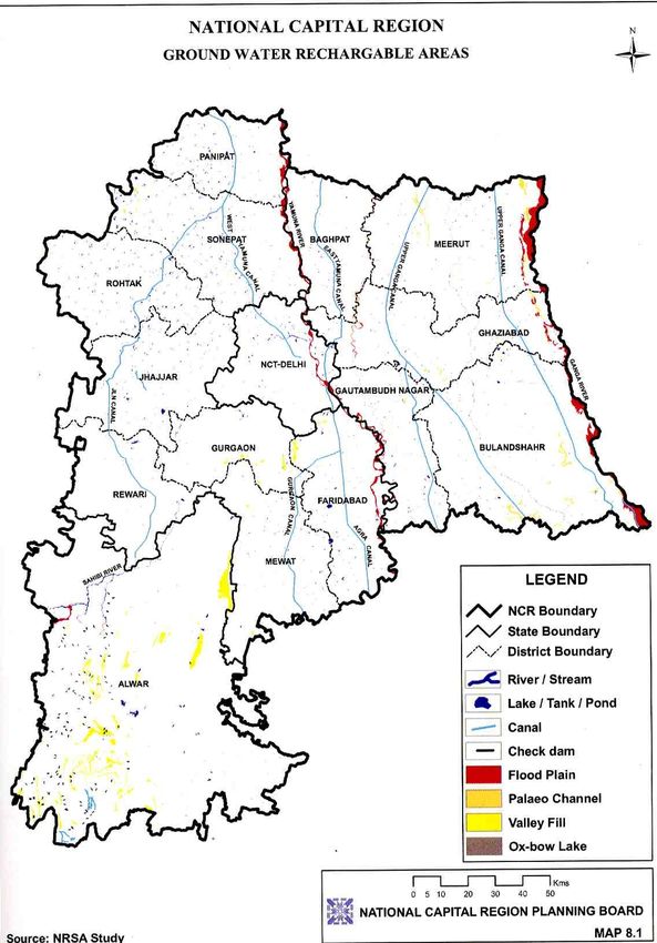
Figure 3-2 : Ground water rechargeable areas in NCR
(iii) The areas under water bodies, ox-bow lakes and paleo-channels and their
surrounding areas as shown in the Ground Water Rechargeable Areas of NCR Plan
Scott Wilson India Page 3-10Preparation of Sub Regional Plan for Haryana Sub-Region of NCR-2021:
Interim Report -II
2021in Figure No.3.1 /Land Use Plan 2021 in Figure No. 2.3 are kept free from any
encroachment/development to allow free flow of water.
Construction activities for human habitation or for any other ancillary purpose thereto not
are permitted. Suitable measures be taken to maintain the water bodies with the minimal
flow/water level.
(iv) In the flood prone areas/river beds/banks, no construction or habitation activities are
permitted. Flood Protection Plan is prepared by the concerned State
Governments/agencies. Policies proposed in the Disaster management chapter at para
15.3 are further elaborated in the Sub-regional Plans, Master/Development Plans and
Flood Protection Plans.
(v) Detailed Conservation Plans be prepared for the areas shown as Natural Area
Conservation Zone in the Land Use Plan 2021.
(vi) The monuments / man-made heritage sites and conservation heritage areas be
identified in the Master/Zonal Plans of each town and detailed conservation plans be
prepared for their protection and conservation.
iv) Agricultural (Rural) Zone outside Controlled/Development/Regulated Areas
Agricultural (Rural) Area of NCR has to be regulated and guided by Village a Block Plans
to be drowning under the district planning process. At the regional level, agriculture
(rural) zone be designated for primary sector production and as open areas comprising
of farmlands, orchards and pastures etc.
The new employment opportunities in non-agriculture sector and consequent
concentration of population, the urban expansions would have to be largely made from
the agricultural land and other non-urban uses. Therefore, there would be a major impact
on land requirements of agriculture sector. In view of this, following policies have been
proposed:
Scott Wilson India Page 3-11Preparation of Sub Regional Plan for Haryana Sub-Region of NCR-2021:
Interim Report -II
(i) Existing cultivated land be conserved for agriculture use as for as possible. Efforts
are made to increase the production through intensive cultivation by providing
irrigation facilities and other necessary infrastructure.
(ii) Measures be initiated for protection of prime agricultural land and ensure its
needless conversion into non-agricultural / urban use.
(iii) Utilization of less and least valuable land for urban expansion/new urban
centres/development purpose.
3.4 Policy for Future Development in Sub-Region
The sub-region development plan will attempt to achieve the objectives enumerated earlier. The
sub region may be divided into four policy zones.
1. The area abutting Delhi up to the KMP corridor (Zone-1)
2. Area between KMP and an arc covering the area from Panipat, Rohtak, Rewari, Hathin &
Hodal (Zone-2)
3. Corridor zones (Zone-3)
4. Rest of the Sub-Region area (Zone-4)
Considering that Hissar has been identified as a counter magnate for NCR the corridor
connecting Delhi, Bahadurgarh, Rohtak and Hissar would need to be emphasized.
The existing corridors viz, Gurgaon-Manesar, Faridabad- Palwal would need to be carefully
planned within the parameters of NCR plan. The new corridors viz, KMP, the Western-Dedicated
Freight Corridor (DFC) connecting Rewari to Palwal would need to be carefully planned to take
advantage of the growth potential. Rewari -Rohtak corridor would similarly require extensive
planning for exploiting the development potential. The Delhi Mumbai Industrial Corridor (DMIC)
being planned along the DFC where specific Investment regions and Industrial areas are being
planned by the Govt. of India and the respective State govt. needs to be incorporated in the Sub
regional plan. The Manesar – Bawal Investment region, Rewari - Hissar Investment region,
Kundli-Sonipat Industrial Area lie in the Haryana sub region. The upcoming Multi-product SEZ
Scott Wilson India Page 3-12Preparation of Sub Regional Plan for Haryana Sub-Region of NCR-2021: Interim Report -II promoted by Reliance Industries at Jhajjar also lies in the sub-region. Numerous smaller SEZ and Industrial estates are also being planned. Figure 3-3 Policy Zones of Haryana Sub-Region Scott Wilson India Page 3-13
Preparation of Sub Regional Plan for Haryana Sub-Region of NCR-2021:
Interim Report -II
Areas for conservation, which have been identified in the NCR plan and which are revealed in
detailed analysis of land use identifying water resources such as streams, canals, water bodies
would be protected against intrusive development and conserved.
Highly productive agricultural land would similarly need protected and conserved. All forest
areas in the sub region would be protected and no development would be permitted within one
kilometer from the perimeter of the forest. Wasteland reclamation through afforestation would be
one of the major concerns of development. Industrial locations would be chosen considering their
potential to pollute the environment and industrial zoning atlas as recommended by CPCB would
be adopted for choice of location suitability.
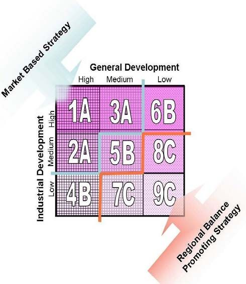
3.5 Policy Sub-Zones for Future Development in Sub-Region
After overlapping NCR Landuse zones and Policy zones and analysis of development potentials
each policy zones will have following policy sub-zones:
Sub-Zone A
This zone will have either high industrial and
high general development status or medium
industrial and high general development or
high industrial and medium general
development. It includes major urban
complexes/towns. This zone is most
developed zone. Therefore this zone will be
treated by market based development
strategy.
Sub-Zone B
This zone will have either high and low development combination or both medium status. It
generally includes smaller towns and surrounding villages around most developed urban ares or
along developed corridors. It can be called as unutilized potential zones which need mixed
approach of development. It does not need more care for development.
Scott Wilson India Page 3-14Preparation of Sub Regional Plan for Haryana Sub-Region of NCR-2021: Interim Report -II Sub-Zone C This zone will have either low industrialisation and low general development or low industrialisation with medium development or low development with medium industrialization. It is the most backward area of the region which creates regional imbalance in the region. Threfore this sub-zone need regional balance promoting strategy. Sub-Zone D This zone will have all the environmentally sensitive area which need to be conserved and treated as per the standard environmental laws and controlled/regulated development zones under which development will be done in controlled way as per the norms and standards . In these areas there will be restricted development. In this zone maximum area is under no development zones and rest are in restricted development. 3.6 Policy for Policy Zones and Sub-Zones in the Sub-Region Sub-Zone A Policy Focus on market driven, rapid economic development and seek to ensure that the economic forecasts are met primarily by focusing on the established industrial areas and the potential problems that might arise from over-development. Policy will main oriented to solving increasing congestion, higher labour, land and housing costs and deteriorating environmental conditions and facilitating infrastructure. Sub-Zone C Policy Focus specifically on encouraging and facilitating those areas which will make the most positive contribution to inclusive growth. This strategy will seek to intervene in the predicted outcome from the economic forecasts, encouraging more extensive and rapid development in the areas which area in need of development. These area need high socio-economic development initiatives to remove regional imbalance and inequality. Scott Wilson India Page 3-15
Preparation of Sub Regional Plan for Haryana Sub-Region of NCR-2021:
Interim Report -II

Sub-Zone B Policy

This area needs mixed approach of Zone A and Zone C. In this zone only providing necessary
infrastructure facilities will induce socio-economic development

Sub-Zone D Policy

This zone is either environmentally sensitive or comes under controlled/regulatory zone . So in
this zone various strict regulations have to be adopted. Areas for conservation, which have been
identified in the NCR plan and which are revealed in detailed analysis of land use identifying
water resources such as streams, canals, water bodies would be protected against intrusive
development and conserved. Highly productive agricultural land would similarly need protection
and conservation.

3.7 Zoning Regulations:

Keeping in view rapid urbanization, environmental degradation and to ensure orderly
development in the region, a legislative tool in the form of Zoning Regulation is required. In view
of this, four broad zones have been identified for application of strict land use control and
development and enabling preparation for detailed Plans such as Sub-regional/Master/Local
Area Plans and Master/Development Plans by the respective State Governments. Four broad
zones and major activities/uses permitted in these zones are given below:

 1.     Controlled / Development/regulate Zone:

  (a) Urbanisable Areas (including existing built-up/urban areas)

        Within the Urbanisable are proposed in the Master/Development Plan of the respective
        towns, the functions and uses designated as under be continued:

        (i) Residential

        (ii) Commercial

        (iii) Industrial

        (iv) Government offices, public and semi-public

Scott Wilson India                                                                 Page 3-16
Preparation of Sub Regional Plan for Haryana Sub-Region of NCR-2021:
Interim Report -II
(v) Recreational
(vi) Utility services
(vii) Transport and communications
(viii) Open spaces, parks and playgrounds
(ix) Graveyards/cemeteries and cremation ghats
(x) Man-made heritage areas
(xi) Natural heritage areas/eco-sensitive areas/conservation areas
The local authority according to the prescribed uses in the Master/Development Plans will
govern detailed land uses within the Urbanisable area. The Master/Development Plans of
all the towns will be prepared within the framework of the Regional Plan – 2021 and
Sub-regional Plans. In case any amendment is required in the acts to implement the
policies of Regional Plan – 2021 that be done by the respective State Governments
appropriately.
(b) Agriculture (Rural) Zone within Controlled/Development / Regulated Areas
1) Agricultural, horticultural crops and cash crops
2) Dairy and poultry farming including milk chilling station and pasteurization plants
3) Social forestry / plantations including afforestation
4) Non-polluting industries registered as RSI/SSI units subject to one of the following
conditions:
(i) Located within half kilometer belt encircling the existing village abadi and
approachable from a public road/rasta other than scheduled road, national
highways and state highways
Scott Wilson India Page 3-17Preparation of Sub Regional Plan for Haryana Sub-Region of NCR-2021:
Interim Report -II
(ii) On public road/rasta not less than 30 feet wide other than schedules roads
national highways and state highways outside the half kilometer zone referred to
in above up to a depth of 10 meters along the approach road.
5) Non-polluting agro-based industries on public roads/revenue rasta not less than
30 feet wide other than scheduled roads, National Highway and State Highway.
6) The site should not fall within 900 meters restricted belt around defence
installations.
7) Land drainage and irrigation by hydro-electric works and tube well for irrigation
8) Sanitary landfill, compost processing plant and other such activity sites with
adequate protected belt as prescribed in the CPHEEO Manual of the Ministry of
Urban Development and Poverty Alleviation and the notifications issued by the
Ministry of Environment and Forests from time to time.
9) Mining and extraction operations including lime and brick kilns, stone quarries
and crushing subject to the rules and approved site.
10) Bus queue shelter and railway station.
11) Airports with necessary buildings
12) Wireless Station
13) Grain godowns, storage spaces at site approved by competent authority
14) Weather station
15) Telephone and electric transmission lines and poles
16) Cremation and burial grounds
17) Fuel filling station, Service stations and repair workshops
18) Power plant/sub-station/water works/treatment plants and other utility services
Scott Wilson India Page 3-18Preparation of Sub Regional Plan for Haryana Sub-Region of NCR-2021:
Interim Report -II
19) Storage godowns for inflammable petroleum products such as LPG, petrol, diesel,
kerosene, aviation turbine fuel, light diesel o8il and other petroleum products and
lubricants with the approval of the competent authority
20) Village houses within abadi-deh
21) Farm houses outside abadi-deh, and
22) Expansion of existing village contiguous to abadi-deh including social institutions like
schools, dispensaries, veterinary centres and police posts strictly for the requirements
of the village and located within 500 meters of the abadi-deh, if undertaken as a
project approved or sponsored by the Central Government or State Governments.
23) Recreational/tourist facilities not more than 4.5 meters height, FAR not exceeding 5%
of the plot areas.
(c) Green buffers
i) Approach / service roads
ii) Agriculture and horticulture
iii) Social forestry/plantations including afforestation
iv) Fuel filling stations with amenities like toilets, STD booths small repair shop, small tea
/ soft drink and snack bar (with no cooking facility)
v) Toll Plaza, bus queue shelters, police boot, first aid centers and telephone booth
2. Highway Corridor Zone
The Highway Corridor Zone will have to be notified controlled /development /regulated
area and master/Development Plans will have to be prepared by the respective State
Governments. In the Highway Corridor Zone (excluding green buffers along highways,
activities permitted in ‘Urbanisable area’, ‘agriculture zone within
development/controlled/regulated areas’ and the ‘green buffers’ prescribed in paras
Scott Wilson India Page 3-19Preparation of Sub Regional Plan for Haryana Sub-Region of NCR-2021:
Interim Report -II
17.5.1(a), 1(b) and 1(c) of Zoning Regulations will be permitted through
Master/Development Plans. The competent authority will regulate access to the
expressways and highways.
3. Natural Conservation Zone:
In this zone the following uses activities may be permitted:
i) Agriculture and horticulture
ii) Pisiculture
iii) Social forestry/plantations including afforestation
iv) Regional recreational activities with no construction exceeding 0.5% of the area with
the permission of the competent authority.
4. Agriculture (Rural) Zone outside Controlled / Development / Regulated Areas
In the agriculture (rural) area zone outside controlled/development/regulated areas the
following activities / uses may be permitted in addition to the activities / uses permitted in
the “agriculture zone within controlled / development / regulated area’ as indicated:
i) Intensive agriculture and allied activates such as dairying and poultry farming
ii) Afforestation especially on the wastelands and barren lands
iii) Regional recreational uses such as, regional parks, wildlife sanctuary etc.
iv) Cemeteries, schools, hospitals, etc
v) Quarrying
vi) Brick kilns
vii) Existing village Mandis / agricultural markets
viii) Rural industries
Scott Wilson India Page 3-20You can also read