Submission to the Draft Galway County Development Plan 2022-2028 (Stage 2) - Lands at Montiagh Road, Baile Chláir, Co. Galway
←
→
Page content transcription
If your browser does not render page correctly, please read the page content below
Submission to the Draft
Galway County Development
Plan 2022-2028 (Stage 2)

Lands at Montiagh Road, Baile
Chláir, Co. Galway
DOCUMENT DETAILS

Client:               Oisin Kenny

Project Title:        Lands at Montiagh Road, Baile Chláir, Co. Galway

Project Number:       210629

Document Title:       Submission to the Draft Galway                County
                      Development Plan 2022-2028 (Stage 2)

Document File Name:   2021.07.30 – Dev Plan Submission –210629– F

Prepared By:          MKO
                      Tuam Road
                      Galway
                      Ireland
                      H91 VW84

Rev       Status      Date            Author(s)       Approved By

01        Final       30.07.2021      DS              CR
Lands at Montiagh Road, Baile Chláir, Co. GalwayLands at Montiagh Road, Baile Chláir, Co. Galway
                                                                                                              210629 - O'Malleys Claregalway DP Submission D3

     Table of Contents
1.   PREAMBLE .......................................................................................................................................... 2
2.   INTRODUCTION .................................................................................................................................. 3
     2.1            Site Description and Constraints ............................................................................................... 3
     2.2            Zoning........................................................................................................................................ 4
3.   PLANNING HISTORY ............................................................................................................................ 6
4.   PLANNING POLICY CONTEXT ............................................................................................................... 7
     4.1            National Planning Framework: Project Ireland 2040 ................................................................ 7
     4.2            Regional Spatial and Economic Strategy (Northern & Western Regional Assembly) 2020-2032
                     ................................................................................................................................................. 7
     4.3            Current Local Planning Policy .................................................................................................... 9
           4.3.1            Galway County Development Plan 2015-2021................................................................................. 9
           4.3.2            Gaeltacht Plan – Variation No. 2(b) Galway County Development Plan 2015- 2021 ....................... 9
     4.4            Galway Transport Strategy (2016) .......................................................................................... 10
5.   PURPOSE OF THE SUBMISSION ......................................................................................................... 11
     5.1            ‘Residential Phase 1’ Lands Assessment ................................................................................. 12
     5.2            Promotion of Subject Lands to Residential Phase 1 ................................................................ 13
6.   CONCLUSION .................................................................................................................................... 16

     TABLE OF TABLES
     Table 1: Planning Applications in the vicinity of the site ............................................................................................ 6

     TABLE OF FIGURES
     Figure 1: Site Location (Site Outlined in Red)............................................................................................................ 3
     Figure 2 - OPW Flood Map ........................................................................................................................................ 4
     Figure 3 - Previous Zoning (2011-2021)....................................................................................................................... 4
     Figure 4 - Current Zoning (Entire Site Outlined in Blue, Client-owned Lands in Red ............................................... 5
     Figure 5 - Proposed Zoning in Draft Plan (Entire Site Outlined in Blue, Client-owned Lands in Red) ...................... 5
     Figure 6. Figure 21 extracted from the RSES ............................................................................................................. 8
     Figure 7 - Indicative Masterplan ............................................................................................................................... 11
     Figure 8 - ‘Residential - Phase 1’ lands in Baile Chláir’ ............................................................................................. 12
     Figure 9 - Full Site in Blue. Submission Subject Site in Red ..................................................................................... 14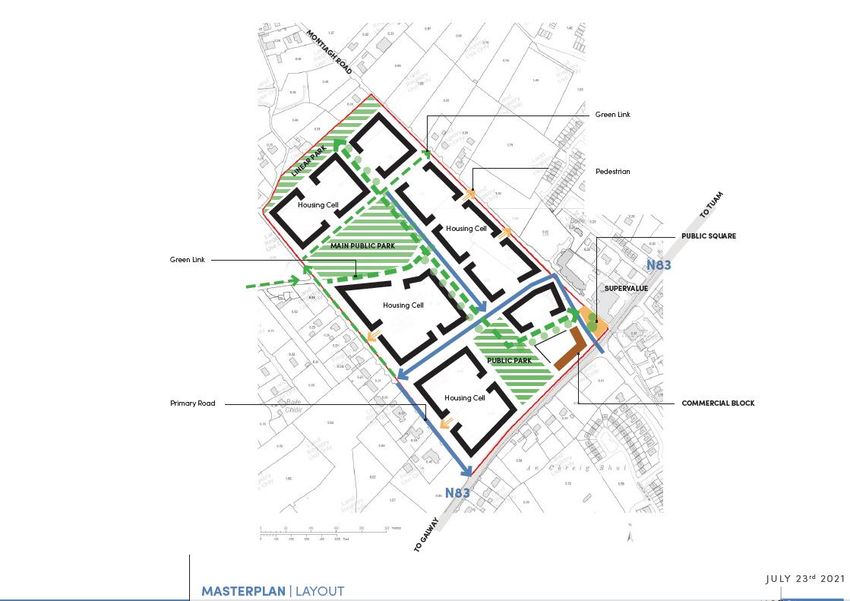
Lands at Montiagh Road, Baile Chláir, Co. GalwayLands at Montiagh Road, Baile Chláir, Co. Galway
                                                                                     210629 - O'Malleys Claregalway DP Submission D3

1.   PREAMBLE
     We note that Galway County Council are in the review process of the existing Galway County
     Development Plan 2015-2021 and preparation of a new development plan for the period 2022-2028 is
     underway. On behalf of our client Oisin Kenny, we wish to make a submission regarding Stage 2 (Draft)
     of the Galway County Development Plan 2022-2028 (hereinafter referred to as the Draft Plan) which was
     published on the 20th of May 2021 and will be on public display until the 30th of July 2021.

     We acknowledge that the development plan for the period 2022-2028 is being prepared in changed
     context to the existing plan 2015-2021. New policy documents have been issued since the adoption of
     Galway County Development Plan 2015-2021, in which there is a new hierarchy of spatial plans that
     support the strategies of the Development Plan. A more urgent national focus on climate change
     mitigation and adaption with implementation of the National Climate Action Plan will be required to
     guide the drafting of policy. Relevant policy documents that have supported the context of the Draft Plan
     include:

              Project Ireland 2040: National Planning Framework
              Regional Spatial and Economic Strategy for the Western and Northern Assembly 2020-2032
              National Climate Action Plan 2019-2024

     MKO have been appointed by Oisin Kenny to prepare this submission on his behalf. In response to the
     contents of the Volume 2: Metropolitan Area Strategic Plan of the Draft Galway County Development
     Plan 2022-2028, this submission will support the request for a change in zoning from Unzoned Land to
     Phase 1 Residential Land. The reader will note that the land is now better serviced with a new sewer
     network running to the north of the land holding along the Montiagh Road, affording the land greater
     opportunities for residential development in the near future. Additionally, the client has appointed a
     design team to undertake a residential planning application directly to Galway City Council, should the
     land be rezoned.

     This submission is structured as follows:

              Section 1 – Preamble

              Section 2 – Introduction

              Section 3 – Planning Policy Context

              Section 4 – Assessment

              Section 5 – Purpose of Submission

              Section 6 – Conclusion

                                                                                                                                      2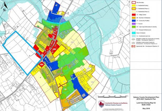
Lands at Montiagh Road, Baile Chláir, Co. GalwayLands at Montiagh Road, Baile Chláir, Co. Galway
210629 - O'Malleys Claregalway DP Submission D3
2. INTRODUCTION
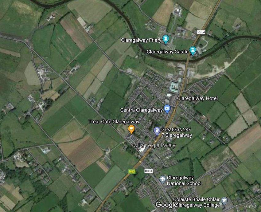
The subject lands are located south of Montiagh Road and west of the N83, Baile Chláir, Co. Galway.
Figure 1 below illustrates the location of the lands within the wider area. This submission to the Draft
Galway County Development Plan (2022-2028) will present a case for development on the lands outlined
below. This report will aim to provide clarity on the constraints and opportunities at the site, and will
show that Baile Chláir, having undergone much infrastructural improvement in recent years is primed
for further development, specifically residential development. The report will show that despite
favourable zoning, Baile Chláir has failed to deliver the housing required to accommodate future
populations, and that the subject site, if rezoned can contribute towards addressing this issue.
Figure 1: Site Location (Site Outlined in Red)
2.1 Site Description and Constraints
The subject lands are located south of Montiagh Road and west of the N83, on the southern approach to
the village. The land on the site is low lying flat pastureland, separated by areas of scrub and hedgerow.
There are a number of agricultural buildings on the site. No habitable dwellings are present. Currently,
the site is mainly accessed via the N83 and an access road leading from Montiagh Road.
National Monuments Service
There are no National Monuments or Protected Structures on or in close proximity to the site.
3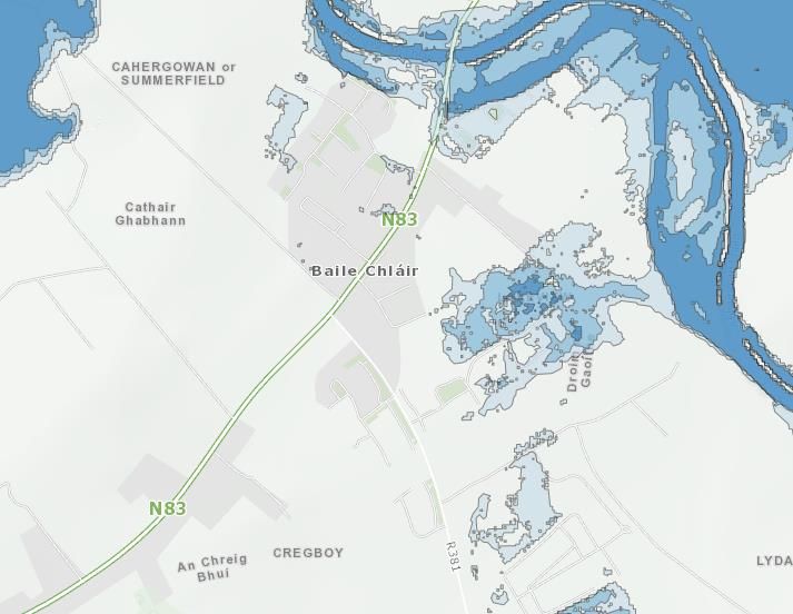
Lands at Montiagh Road, Baile Chláir, Co. GalwayLands at Montiagh Road, Baile Chláir, Co. Galway
210629 - O'Malleys Claregalway DP Submission D3
Flood Risk
The site is not located in a high flood risk area. See OPW flood map below.
Figure 2 - OPW Flood Map
Designated Areas
There are no Special Protection Areas or Special Areas of Conservation on the site. The nearest SAC is
the Lough Corrib SAC, approximately 05km to the north of the site.
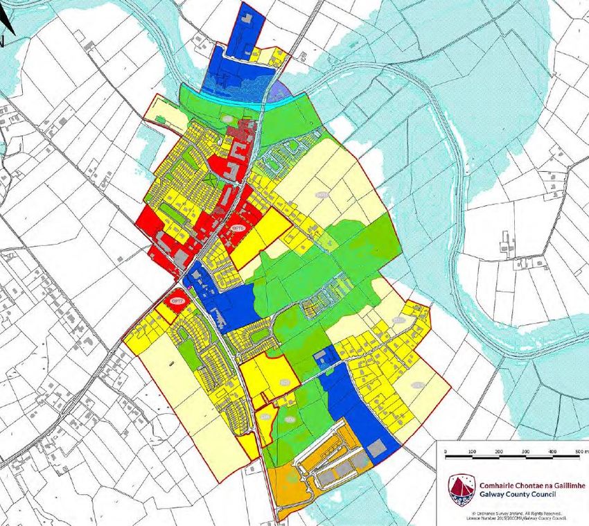
2.2 Zoning
Previous Zoning (Galway County Development Plan 2005 – 2011)
As illustrated above, the northeastern section of the site had previously been zoned for Phase 1
Residential, Phase 2 Residential and Commercial uses. This demonstrates the suitability of the site for
such uses, and highlights the Authority’s confidence in the potential for development in this area of Baile
Chláir.
Current Zoning (Galway County Development Plan Variation 2b – Gaeltacht Plan 2015-2021)
As illustrated in the above map, the majority of the land had been downzoned in the Gaeltacht Plan 2015-
2021. The southeastern corner of the land was maintained within ‘Village Centre’ zoning.
Figure 3 - Previous Zoning (2011-2021) 4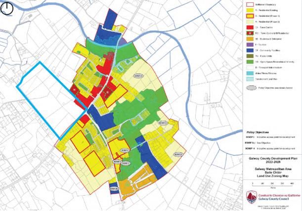
Lands at Montiagh Road, Baile Chláir, Co. GalwayLands at Montiagh Road, Baile Chláir, Co. Galway
                                                                                     210629 - O'Malleys Claregalway DP Submission D3

Figure 4 - Current Zoning (Entire Site Outlined in Blue, Client-owned Lands in Red

Draft Zoning (Draft Galway County Development Plan 2022-2028)

As demonstrated in the above zoning map for the Draft Galway County Development plan, the land-use
zoning for the subject site is proposed to remain the same as the zoning in the exiting (2015-2021) County
Development Plan.

Figure 5 - Proposed Zoning in Draft Plan (Entire Site Outlined in Blue, Client-owned Lands in Red)

                                                                                                                                      5
Lands at Montiagh Road, Baile Chláir, Co. GalwayLands at Montiagh Road, Baile Chláir, Co. Galway
                                                                                             210629 - O'Malleys Claregalway DP Submission D3

3.   PLANNING HISTORY
     According to the Galway County Council online planning portal there are a number of applications on
     the subject site as below in Table 1.

     Table 1: Planning Applications in the vicinity of the site

      Pl Ref.         Applicant                          Development Description                                  Decision
      15252           Oisin Kenny                        for the erection of a five bay glass house               Granted                on
                                                         with a floor area of 544sqm and ancillary                08/06/2015
                                                         development of yard, water supply
                                                         pump house and relocation of small tool
                                                         container (gross floor space 550sqm)
      16604           Oisin Kenny                        for the erection of a twelve bay glass                   Granted                on
                                                         house with a floor area of 2560sqm and                   29/06/2016
                                                         ancillary development of yard and
                                                         associated services

                                                                                                                                              6
Lands at Montiagh Road, Baile Chláir, Co. GalwayLands at Montiagh Road, Baile Chláir, Co. Galway
210629 - O'Malleys Claregalway DP Submission D3
4. PLANNING POLICY CONTEXT
This submission has been prepared with cognisance to the following planning policy documents;
National Planning Framework: Project Ireland 2040
Regional Spatial & Economic Strategy for the Northern & Western Regional Assembly 2020-
2032
Galway County Development Plan Variation 2b Gaeltacht Plan 2015-2021
Draft Galway County Development Plan 2022-2028
4.1 National Planning Framework: Project Ireland 2040
In 2018, the Government of Ireland adopted the National Planning Framework (NPF) entitled Ireland
2040 to succeed the National Spatial Strategy. The NPF comprises the Government’s proposed long-term
strategic planning framework to guide national, regional and local planning and investment decisions
over the next 25 years. It is intended that the NPF will be a strategic document that will provide the
framework for future development and investment in Ireland, providing a long-term and place-based
aspect to public policy and investment, and aiming to coordinate sectoral areas such as housing, jobs,
transport, education, health, environment, energy and communications, into an overall coherent strategy.
The NPF has a number of national policy objectives that articulate delivering on a compact urban growth
programme and are relevant to the Board’s consideration of the proposed Strategic Housing
Development. These include:
National Policy Objective (NPO) 1 (b) relating to population growth in the region;
National Policy Objectives (NPO) 2(a) relating to growth in our cities;
NPO 4 relating to attractive, well-designed liveable neighbourhoods;
NPO 5 relating to sufficient scale and quality of urban development; and
NPO 6 relating to increased residential population and employment in urban areas.
National Policy Objective 1b states in the context of population growth to 2040:
‘Northern & Western Region – population growth of 180,000 additional people.’
There is a very significant population growth allocated to the Northern & Western Region in which
Galway is the main urban centre. In order to facilitate this population growth there will be a requirement
to develop large numbers of new houses and apartments, approx. 20,000 units based on a standard
household size of 2.7 people. Given Galway is currently acutely affected by the housing crisis there is a
considerable progress to be made in order to bring housing provision from its current under-supply to
the level required to accommodate the population growth forecasts. However, it is important that more
sustainable development patterns are established in order to facilitate targeted services and infrastructure
investment.
4.2 Regional Spatial and Economic Strategy (Northern &
Western Regional Assembly) 2020-2032
The Regional Spatial & Economic Strategy for the Northern & Western Regional Assembly 2020-2032
(RSES) was adopted on 24th January 2020. The purpose of the RSES is to support the implementation
of the National Planning Framework and the economic policies and objectives of the Government by
providing a long-term strategic planning and economic framework for the development of the regions.
Section 3.6 of the RSES sets out the Galway Metropolitan Area Strategic Plan (MASP). The Vision of the
MASP is that Galway will be a leading global city, renowned as a successful, sustainable, competitive,
compact and accessible city of scale that supports a high quality of life, maintains its distinctive identity
and supports its rich heritage, language and cultural experience.
7Lands at Montiagh Road, Baile Chláir, Co. GalwayLands at Montiagh Road, Baile Chláir, Co. Galway
210629 - O'Malleys Claregalway DP Submission D3
The RSES outlines arrangements for a co-ordinated metropolitan area strategic plan (MASP) for the
Galway Metropolitan Area. The MASP has been provided with statutory underpinning to act as a 12-
year strategic planning and investment framework. The MASP is an opportunity for Galway to address
recent growth legacy issues and build on key strengths, including a vibrant arts and cultural scene, year-
round tourism and an attractive natural setting.
A number of strategic locations have been identified that present the opportunity and capacity to deliver
the necessary quantum of housing and development to facilitate targeted growth. Baile Chláir is identified
as one of these strategic locations, which are summarised on Page 53 of the RSES and are illustrated in
the MASP map (see map below).
Figure 6. Figure 21 extracted from the RSES
The table on Page 54 of the RSES identifies that the approximate land area designated for “Land Capacity
– Lands Available for Housing” in Baile Chláir is 7Ha.
The RSES (pg 55) sets out objectives specific to Baile Chláir, as follows:
Baile Chláir is located to the north-east of the metropolitan area, within Gaeltacht na Gaillimhe
(County Galway Gaeltacht). It supports many local shops, commercial/business units, hotel
accommodation and significant residential accommodation. The village remains a desirable
residential location benefiting from its accessibility to commute to work in the larger urban
centres of Galway City and Tuam, as well as the industrial area of Parkmore. Recent
infrastructure investment include drainage works to alleviate flooding, a new bridge, secondary
school and a new wastewater treatment plant, which have provided additional capacity to meet
the current and future needs. The development of the village requires ongoing careful
management whilst recognising its natural, built and cultural heritage assets. The implementation
of the GTS will be influential in ensuring the sustainable development of the town.
It is clear from the above objectives that Baile Chláir is primed for further sustainable development. Many
improvements have been made to the village in preparation for this, including:
New wastewater treatment plant
New drainage works to alleviate flooding
New bridge
New Secondary School
8Lands at Montiagh Road, Baile Chláir, Co. GalwayLands at Montiagh Road, Baile Chláir, Co. Galway
210629 - O'Malleys Claregalway DP Submission D3
4.3 Current Local Planning Policy
4.3.1 Galway County Development Plan 2015-2021
The proposed site is governed by the policies and provisions contained in the Galway County
Development Plan 2015-2021 (CDP). The plan was adopted by the Members of Galway County Council
on 26th January 2015 and the Plan is effective from 23rd February 2015.
The CDP sets out an overall strategy for the proper planning and sustainable development of the
functional area of Galway County Council. Chapter 2 of the Plan sets out the overarching Spatial Strategy
of the County, references the development options considered for the growth and details the preferred
development option chosen. It details the Core Strategy, including the statutorily required Map and Core
Strategy Table and sets out the application of regional population targets to the Core Strategy and the
settlement hierarchy determined as part of the Spatial Strategy. Finally, it also outlines the policies and
objectives in relation to the Core and Settlement Strategy for the County.
The Core Strategy is an integral component of the Spatial Strategy. It transposes the population targets
for Galway set out in the Regional Planning Guidelines and allocates them throughout the County, which
in turn determines the Settlement Hierarchy and provides a rationale for the amount and location of land
proposed to be zoned.
The Core Strategy Table in the current CDP includes a list of all key towns and larger villages and
provides a population growth allocation for each for the period 2015 to 2021. The Core Strategy Table
also includes an assessment of the quantum of residentially-zoned land available to meet the population
growth allocation.
The village of Baile Chláir is on the fourth tier of the settlement hierarchy (Other Villages) and has a total
population allocation of 245 people under the Core Strategy in the GCDP, which is equivalent to a
housing land requirement of 7.1 hectares. Taking an average household size of 2.4 (as referred to in the
section 2.4.11 of the GCDP), the growth allocation requires approximately 100 new housing units up to
2021.
It should be noted that the duration of the Baile Chláir Local Area Plan i.e. 2005-2011 coincided with the
economic downturn and the subsequent impact that this had on housebuilding countrywide must be
taken into consideration. It is considered that the level of housing completed in Baile Chláir between
2006 and the present day has not been sufficient to accommodate the growing population of the
settlement. Furthermore, there is currently a housing crisis effecting the country as a whole. Completed
housing units are urgently required to address this crisis but also to accommodate population growth in
the settlement as per the Core Strategy set out in the Galway County Development Plan.
4.3.2 Gaeltacht Plan – Variation No. 2(b) Galway County
Development Plan 2015- 2021
Variation No. 2(b) to the Galway County Development Plan 2015 – 2021 incorporated the Gaeltacht Plan
into the Galway County Development Plan 2015-2021 which informs and manages the future
development of the Gaeltacht area. The Gaeltacht Plan replaces the previous planning document
Gaeltacht Plan 2008-2018. The Gaeltacht area is divided into six distinct districts:
▪ Iorras Aithreach/Camas/Ros Muc;
▪ Dúiche Sheoigheach;
▪ Ceantar na nOileán/An Crompán;
▪ Cois Fharraige;
▪ Oileáin Árainn;
▪ Imeall na Cathrach.
9Lands at Montiagh Road, Baile Chláir, Co. GalwayLands at Montiagh Road, Baile Chláir, Co. Galway
210629 - O'Malleys Claregalway DP Submission D3
4.4 Galway Transport Strategy (2016)
The Galway Transport Strategy (GTS) 2016 represents a partnership approach between Galway City
Council, Galway County Council and the National Transport Authority. It includes a series of measures
which will address the transport problems experienced across the city particularly during peak hours,
over a phased and co-ordinated basis over the next 20 years, based on priority needs. The GTS has
established that the reduction in traffic congestion requires both improvements to public transport, cycling
and walking networks and the provision of a new orbital route.
The study area for the GTS comprises the Galway City Council administrative area, and the surrounding
hinterland within the Galway County Council administrative area, with the settlements Bearna,
Oranmore, Maigh Cuilinn (Moycullen), and Baile Chláir (Baile Chláir).
Baile Chláir is located within the GTS area and is subject to the development policies and controls that
apply in this area under the Galway CDP. The GTS states the following:
“Focus on main County Towns – encouraging the development of the main towns within
Galway’s catchment including Tuam, Oranmore, Athenry, Loughrea and Gort, as well
as satellite towns of Oughterard, Headford, Baile Chláir, Moycullen, Bearna and Spiddal,
and Linking these to Galway City Via a fixed route radial network, serving the main
towns and villages and a ‘Dial-a-bus’ facility to serve the rural areas outside the fixed
routes.”
The proposed measures were arrived at following transport modelling, defining the existing transport
problems, predicting future travel demands, access mode share and assessing their mutual impacts and
interdependencies. The strategy includes traffic management, giving priority to walking cycling and bus
movements, modifications to the traffic network, management of parking activities and heavy goods
vehicles, improvements to the public realm and use of ‘smarter mobility’. These measures are designed
to both address the current significant problems and inefficiencies in the movement of people and goods
within and around the city and to establish a long-term transport plan that will underpin the future
sustainable growth of the city as supported by the Core Strategy.
The intentions of the Galway Transport Strategy are to connect the towns and villages in the Galway
MASP Area, in order that transport and connectivity across the whole area is reliable, frequent,
sustainable, supporting future development. The GTS will strengthen the position of Baile Chláir in terms
of its proximity to Galway City and surrounding Towns and villages, and enhancing its development
potential.
10Lands at Montiagh Road, Baile Chláir, Co. GalwayLands at Montiagh Road, Baile Chláir, Co. Galway
210629 - O'Malleys Claregalway DP Submission D3
5. PURPOSE OF THE SUBMISSION
As illustrated in the maps above, the lands are located on site which has been subject to a number of
zonings over the previous two development plans. Most notably, up until 2011 the north-eastern section
of the site was zoned for ‘Residential Phase 1’, ‘Residential Phase 2’, and ‘Commercial’. On behalf of our
client, we wish to contend that this previous zoning remains a sustainable development objective for Baile
Chláir, and respectfully request that the previous zoning, in part, be reinstated.
The aim of this submission is to demonstrate the following points:
There has been insufficient residential development in Baile Chláir;
‘Phase 1 Residential’ zoned land in Baile Chláir remains largely undeveloped;
The subject lands are a suitable and viable option to deliver housing in Baile Chláir;
The subject lands are bounded on all sides by well-established roads, and benefit from excellent
access and connectivity;
The location of the subject lands provides an opportunity to deliver consolidation of the southern
areas of Baile Chláir in a balanced manner.
Our client has commissioned a Masterplan demonstrating the potential of the subject lands. See below
Masterplan drawing.
Figure 7 - Indicative Masterplan
The above masterplan demonstrates a vision for the land, considering its development potential, the
existing ‘Village Centre’ zoning on the eastern corner of the site, proximity to both Baile Chláir and
Galway City, and proximity to utilities, services and amenities in Baile Chláir.
Essentially, we contend that the site in its entirety is suited to further development in the near future.
However, we also recognise that rezoning of lands should be carried out in a phased and measured
manner, and for this reason we contend that the section of land outlined in pink in the above masterplan
be zoned for ‘Residential Phase 1’ development. Our argument for this is set in the sections below.
11Lands at Montiagh Road, Baile Chláir, Co. GalwayLands at Montiagh Road, Baile Chláir, Co. Galway
210629 - O'Malleys Claregalway DP Submission D3
5.1 ‘Residential Phase 1’ Lands Assessment
The extant Gaeltacht Plan is due to be replaced this year (2021). An assessment of Phase 1 Residential
lands in Baile Chláir is presented below and demonstrates that the majority of Phase 1 land remains
undeveloped to this day.
Given the current housing crisis in Ireland in tandem with a lack of residential development, it is
considered appropriate to propose alternative sites for development. We have undertaken an assessment
to establish how many residential developments have been committed to development in Baile Chláir
over the life of the current Plan. We have focused in particular on all of the lands zoned ‘Residential -
Phase 1’ in the current Gaeltacht Plan in order to establish the following:
1. What proportion of ‘Residential - Phase 1’ lands have been committed to development?
2. Of those ‘Residential - Phase 1’ lands that have not been committed to development, is there
evidence of any constraints associated with those lands to explain why they have not been
committed to development to date and are unlikely to be committed to development by 2021
(i.e. when the extant Plan is due to expire).
Figure 8 identifies five no. relevant parcels of land zoned ‘Residential - Phase 1’ within the LAP boundary.
1
5
2
3
4
Figure 8 - ‘Residential - Phase 1’ lands in Baile Chláir’
12Lands at Montiagh Road, Baile Chláir, Co. GalwayLands at Montiagh Road, Baile Chláir, Co. Galway
210629 - O'Malleys Claregalway DP Submission D3
We have undertaken a systematic planning search of all lands zoned ‘Residential - Phase 1’ in the Plan
boundary (i.e. areas that are shaded yellow with a red outline) above and set out the development status
and constraints associated with those lands in Table 5. The key criterion for establishing if a developer
intends to bring a site forward for development is the submission of a Commencement Notice, within the
meaning of Part II of the Building Control Regulations 1997, to the Planning Authority to indicate
commencement of works.
The Core Strategy of the Galway County Development Plan predicts a population increase of 245 for the
village of Baile Chláir. In other words, we understand that Galway County Council’s plan-led vision for
Baile Chláir is that it can accommodate an additional approximately 100 new housing units up to 2021.
This is based on an average household size of 2.4.
At the time of writing, there are numerous constraints associated with 3 out of the 5 areas of land that are
zoned ‘Residential -Phase 1’, primarily relating to access. The other two parcels of lands have no recent
planning history.
Table 1 - Phase 1 Land Stats
Map Ref Committed to Dev Evidence of Relevant No of Description of
Constraints Planning Ref Units Constraints
No’s
1 No Yes N/A 0 New access would be
required due to sub-
standard nature of access
road and junction with
N83 National Secondary
Road.
2 No Yes 06/991 0 Traffic Hazard
3 No No N/A 0 N/A
4 No No 05/1510 0 N/A
5 No Yes N/A 0 New access onto N83
required.
There are currently no extant planning permissions for residential development on Phase 1 zoned lands
in Baile Chláir and the permissions referenced for parcels 2 and 4 have since expired.
5.2 Promotion of Subject Lands to Residential Phase 1
The purpose of this element of the submission is to present a case for the zoning of the lands outlined in
red below to ‘Residential Phase 1’. In support of this, the population growth figures in Section 4 clearly
demonstrate a need for further developable land in Galway County and in Baile Chláir, in order to
deliver the housing units required over the plan period and beyond.
Additionally, we have demonstrated a clear problem with the coming forward of any significant
development in Baile Chláir, despite the best efforts of the Authority to zone sufficient parcels of land.
Lands zoned ‘Residential Phase 1’ in Baile Chláir remain largely undeveloped, in the midst of a country-
wide housing crisis. As such, we respectfully suggest that alternative lands are zoned for residential
development.
13Lands at Montiagh Road, Baile Chláir, Co. GalwayLands at Montiagh Road, Baile Chláir, Co. Galway
210629 - O'Malleys Claregalway DP Submission D3
Figure 9 - Full Site in Blue. Submission Subject Site in Red
Baile Chláir is strategically located within the Metropolitan Area of Galway according to the MASP map.
The Metropolitan Area has grown considerably in recent years and there is scope for the potential of
planned future growth, stated within the Draft Plan that “it is anticipated that a substantial proportion of
the increased population will be located within the county Metropolitan Area where there is greater
availability of development land with access to the city”. It is also stated within the Draft Plan that “Baile
Chláir presents opportunities for delivering growth through consolidation”.
Consolidation of existing settlements should promote the coming forward of well serviced, accessible and
sustainable development lands, enhancing the settlement vitality of Baile Chláir. Our client’s lands are
located in proximity to roads, services and existing residential developments, as well as being within
walking distance of Baile Chláir village centre. As illustrated in the maps above, the lands are bounded
to the north, south and east by well serviced roads – one of them being the N83 National Road.
It is our view that the portion of subject lands outlined in red in the map above, should be rezoned to
‘Residential Phase 1’ based on the following:
The lands now benefit from a new sewer network running to the north of the land-
holding along the Montiagh Road;
The client has identified another of his own land holdings for the relocating of the
existing glasshouses and other agricultural building currently on the site;
The client has appointed a design team to undertake a residential planning application
to submit directly to Galway City Council, should the land be rezoned;
There is strong footpath connectivity to the town centre which meets Policy BMSP 15
Pedestrian and Cycle Network of the Draft Plan:
“Encourage and support the development of a series of pedestrian and cycle routes
linking the residential areas to the town and local community services, where feasible”.
14Lands at Montiagh Road, Baile Chláir, Co. GalwayLands at Montiagh Road, Baile Chláir, Co. Galway
210629 - O'Malleys Claregalway DP Submission D3
The lands extend to c18.5ha in its entirety and c6.9ha in the area proposed for rezoning
in this submission. The lands therefore, have the capacity to contribute towards housing
targets for Baile Chláir, as outlined in National, Regional, and Local plans,
There are no apparent constraints associated with the subject lands; there are no
ecological designations on the site, no cultural or archaeological sites, no flood zones
or recorded flood events, and no concerns with access. Indeed, the client acknowledges
all constraints in the vicinity of the lands intends to incorporate these considerations
into any future development, to protect both the ecology and the archaeology of the
area.
Residential development at this location meets both National and Regional policy objectives and
population growth targets as outlined in Section 4.1 and Section 4.2. The assessment of projected
population growth targets indicates that there is a significant increase required in providing a variety of
house types for a growing population, a figure that has since been challenged and is higher than initially
anticipated. Additionally, there is a distinct lack of residential development in Baile Chláir, despite
favourable zoning, necessitating consideration of alternative sites to deliver housing in the village.
It is the request of this submission that Galway County Council recognise the potential of these lands and
the opportunity for growth in Baile Chláir.
15Lands at Montiagh Road, Baile Chláir, Co. GalwayLands at Montiagh Road, Baile Chláir, Co. Galway
210629 - O'Malleys Claregalway DP Submission D3
6. CONCLUSION
In summary, we contend the above report demonstrates a positive case for the rezoning of the subject
lands.
The subject lands are optimally located along the N83 National Route, to the south and west of the
established development in Baile Chláir, and benefit from existing on-site ‘Village Centre’ zoning. The
Authority has shown its confidence in the potential of the site by previously zoning it, in part for both
residential and commercial development – which we respectfully suggest is, in part, reinstated.
Baile Chláir has been ‘upgraded’ recently, with a new wastewater treatment plant, new secondary school,
and new Flood Risk Strategy. The village is now primed for further development. However, a case for
alternative development sites has become necessary given the lack of forthcoming residential
development in Baile Chláir, despite favourable zoning.
We therefore respectfully request that the lands discussed in this report are zoned ‘Phase 1 Residential’,
in the interests of accommodating population growth in Baile Chláir and in the national interest where
housing stock deficit has become a grave problem.
16You can also read