DRAFT PRECINCT PLAN Muldersdrift Precinct Mogale City Local Municipality - 30 September 2020 - Alpha Portal
←
→
Page content transcription
If your browser does not render page correctly, please read the page content below
30 September 2020

DRAFT PRECINCT PLAN
Muldersdrift Precinct
Mogale City Local Municipality
MULDERSDRIFT DRAFT PRECINCT PLAN

Table of Contents                                                                                                NON-RESIDENTIAL DEVELOPMENT ............................................ 33
                                                                                                                 ROAD NETWORK ......................................................................... 35
                                                                                                           DEVELOPMENT CONCEPT.................................................................. 38
    INTRODUCTION ..................................................................................... 4
                                                                                                                 INTRODUCTION ........................................................................... 38
          THE MAGALIESBURG PRECINCT .................................................. 4
                                                                                                                 STRUCTURING ELEMENTS ............................................................ 38
          METHODOLOGY ........................................................................... 7
                                                                                                                        ENVIRONMENTAL FACTORS ............................................... 38
    VISION AND OBJECTIVES ................................................................... 10
                                                                                                                        DEVELOPMENT CORRIDOR ................................................ 40
          VISION STATEMENT ...................................................................... 10
                                                                                                                        ACTIVITY SPINES .................................................................. 42
          DEVELOPMENT OBJECTIVES ...................................................... 10
                                                                                                                        NODES AND CONCENTRATIONS ...................................... 45
    BACKGROUND INFORMATION .......................................................... 12
                                                                                                                        RESIDENTIAL TYPOLOGIES AND DENSITIES ........................ 46
          MUNICIPAL CONTEXT ................................................................. 12
                                                                                                           WAY FORWARD .................................................................................. 49
          SPATIAL POLICY FRAMEWORKS ................................................. 13
          MACRO-ECONOMIC PROFILE .................................................. 15
          HOUSEHOLD PROFILE ................................................................. 17
          POPULATION GROWTH .............................................................. 18
          RESIDENTIAL MARKET POTENTIAL ............................................... 20
                 METHODOLOGY ................................................................. 20
                 POPULATION PROFILE ........................................................ 20
                 HOUSEHOLD INCOME ........................................................ 20
                 CUMULATIVE NET EFFECTIVE RESIDENTIAL DEMAND ....... 20
          RESIDENTIAL DEVELOPMENT ...................................................... 23
                 DIFFERENT RESIDENTIAL TYPOLOGIES ................................ 23
                 INFORMAL SETTLEMENTS .................................................... 26
                 HUMAN SETTLEMENT PROJECTS......................................... 30
          HOUSEHOLD DEMAND AND SUPPLY ........................................ 32

                                                                                                                                                                                                            i
September 2020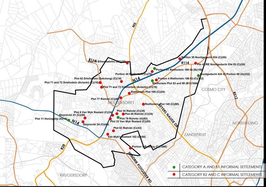
MULDERSDRIFT DRAFT PRECINCT PLAN

List of Figures                                                                                         List of Tables
Figure 1: MULDERSDRIFT SUB-REGION ........................................................ 5            Table 1: MULDERSDRIFT SUB REGION POPULATION AND HOUSEHOLD
Figure 2: MULDERSDRIFT PRECINCT BOUNDARY ........................................ 6                     FIGURES ....................................................................................................... 18
Figure 3: PROJECT PHASES .......................................................................... 8   Table 2: MULDERSDRIFT PRECINCT POPULATION AND HOUSEHOLD
Figure 4: MUNICIPAL CONTEXT ................................................................. 12        FIGURES ....................................................................................................... 18
Figure 5: COMBINED MCLM AND CoJ MM SDFs .................................... 14                         Table 3: MULDERSDRIFT PRECINCT POPULATION AND HOUSEHOLD
Figure 6: ECONOMIC SECTOR CONTRIBUTION SUBREGION .................. 15                                  GROWTH ..................................................................................................... 18
Figure 7: SUB-REGION POPULATION GROWTH ........................................ 19                      Table 4: CUMULATIVE NET EFFECTIVE DEMAND – BONDED ................... 21
Figure 8: PRECINCT POPULATION GROWTH ............................................ 19                    Table 5: CUMULATIVE NET EFFECTIVE DEMAND – RENTAL ...................... 21
Figure 9: Net Effective Demand Equation .............................................. 20               Table 6: SUBSIDISED HOUSING PROJECTS ................................................ 30
Figure 10: HOUSING AFFORDABILITY RANGES ......................................... 22                    Table 7: PROPOSED HOUSING PROJECTS ................................................ 30
Figure 11: RESIDENTIAL CHARACTER ........................................................ 24            Table 8: DEMAND VS SUPPLY .................................................................... 32
Figure 12: DISTRIBUTION OF BUILT STRUCTURES ........................................ 25
Figure 13: INFORMAL SETTLEMENTS ........................................................... 26
Figure 14: EXISTING INFORMAL SETTLEMENTS ........................................... 29
Figure 15: EXISTING INFORMAL SETTLEMENTS ........................................... 31
Figure 16: NON-RESIDENTIAL FACILITIES.................................................... 34
Figure 17: ROAD NETWORK ....................................................................... 36
Figure 18: NATURAL FEATURES ................................................................... 39
Figure 19: N14 DEVELOPMENT CORRIDOR .............................................. 40
Figure 20: ACCESSIBILITY SPINES ALONG THE N14 ................................... 41
Figure 22: PROPOSED ACTIVITY SPINES .................................................... 43
Figure 23: RATIONALISED ACTIVITY SPINES ............................................... 44
Figure 24: NODES AND CONCENTRATIONS ............................................. 45
Figure 25: RESIDENTIAL TYPOLOGIES AND DENSITIES .............................. 46

                                                                                                                                                                                                                         ii
September 2020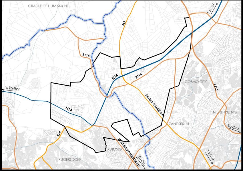
MULDERSDRIFT DRAFT PRECINCT PLAN

                                               iii
September 2020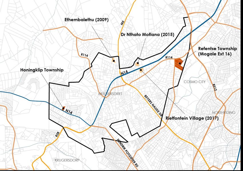
MULDERSDRIFT DRAFT PRECINCT PLAN

    INTRODUCTION
    This document contains the first draft Precinct Plan for the
    Muldersdrift Precinct in the Mogale City Local Municipality.
    The Precinct Plan was commissioned by the Department of
    Agriculture, Land Reform and Rural Development on behalf of
    the Municipality.

      THE MAGALIESBURG PRECINCT
      The Muldersdrift Precinct is 7 727ha in extent. It is centred on
      the area between the municipal boundary and the CoH
      WHS. It is home to major developments such as the
      Cradlestone Mall, Avianto Estate, Misty Hills Conference
      Centre and the Greengate Business Park.

      Detailed designed will be developed for the Precinct but
      reference will be made throughout the document to the
      Subregion, which is the area of influence.

                                                                                                       4
September 2020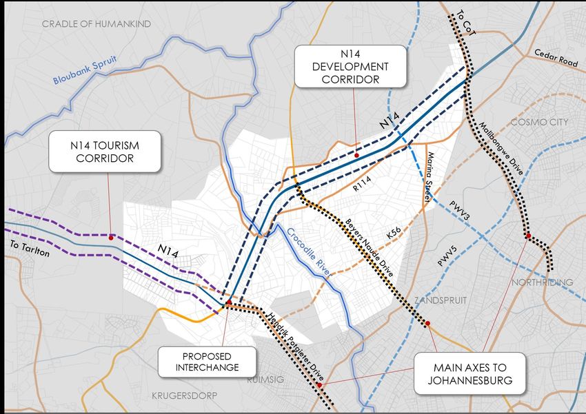
MULDERSDRIFT DRAFT PRECINCT PLAN

                 Figure 1: MULDERSDRIFT SUB-REGION

                                                                                   5
September 2020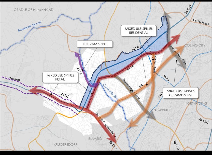
MULDERSDRIFT DRAFT PRECINCT PLAN

                 Figure 2: MULDERSDRIFT PRECINCT BOUNDARY

                                                                                          6
September 2020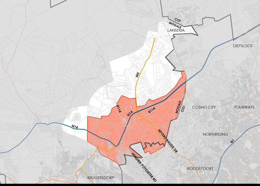
MULDERSDRIFT DRAFT PRECINCT PLAN

                                                                       ▪   Network of special (i.e. symbolic or landmark)
      METHODOLOGY
                                                                           spaces, places, and features
      This section contains the methodology for drafting the           ▪   Provision of social facilities
      Precinct Plan. This report contains Phase 3: draft Precinct      ▪   Definition of areas with different overall built form
      Plan. It follows on the Situational Analysis and Synthesis and       requirements in terms of ‘development grain’,
      it precedes the Implementation Plan. The detail Situational          building density and building height
      Analysis and Synthesis is contained in a separate document       ▪   Designation of areas for densification and/or infill
      and its findings will be summarised in this document.            ▪   Designation of areas for regeneration
                                                                       ▪   Protection and promotion of productive activities
      During this phase a spatial concept will be developed for the        within the precinct and associated regional
      Precinct. The findings of the situational analysis, and the          landscape values within the precinct
      vision and objectives will be used as guiding mechanisms in
      developing the spatial concept.

      The concept consists of a spatial structure including:
           ▪ Open space network (including waterbodies, green
             open spaces and man-made public urban spaces)
             and definition of the general character of different
             types of open spaces (e.g. natural areas, parks,
             squares, streets, boulevards, etc.)
           ▪ Movement network (including road network, railway
             network, major public transport routes and facilities,
             spatial requirements for pedestrian and other non-
             motorised transport) and definition of the hierarchy
             (categorisation) and general character of different
             types of roads, public transport routes and facilities,
             as well as non-motorised transport routes
           ▪ Land use patterns, including activity nodes and
             corridors (spines) and alternative economic uses of
             land
           ▪ Housing typologies, densities, and delivery options

                                                                                                                                      7
September 2020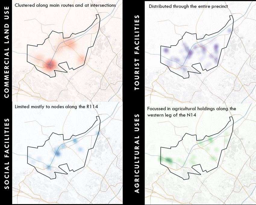
MULDERSDRIFT DRAFT PRECINCT PLAN

                 Figure 3: PROJECT PHASES

                                                                          8
September 2020
MULDERSDRIFT DRAFT PRECINCT PLAN
9
September 2020MULDERSDRIFT DRAFT PRECINCT PLAN
VISION AND OBJECTIVES
VISION STATEMENT
An economically vibrant and socially equitable precinct
focused on the N14 development corridor.
DEVELOPMENT OBJECTIVES
▪ To extract the maximum benefit from the N14
Development Corridor and the Lanseria area of
influence for economic growth and job creation.
▪ To structure rapid settlement growth into a functional
urban form that provides equitable access to services
and facilities and supports public transport.
▪ To provide for a range of housing typologies and
densities in line with levels of accessibility and
environmental carrying capacity.
▪ To balance the divergent needs of urban
development pressure, environmental protection,
poverty and housing need.
10
September 2020MULDERSDRIFT DRAFT PRECINCT PLAN
11
September 2020MULDERSDRIFT DRAFT PRECINCT PLAN
BACKGROUND INFORMATION
MUNICIPAL CONTEXT
The Muldersdrift Precinct is situated in the eastern extent of
Mogale City Local Municipality, flanking the north western
boundary of the City of Johannesburg in the region of
Cosmo City/ Randburg/ Ruimsig. These areas exert
significant development pressure on the Muldersdrift area,
which in essence functions as the urban-rural fringe of
Johannesburg.
To the north-west it is linked to the City of Tshwane via the
N14 which is increasingly taking on the character of a
development corridor, specifically with the locality of
Lanseria airport on the boundaries of the municipalities of
Johannesburg, Tshwane and Mogale City.
Figure 4: MUNICIPAL CONTEXT
It is within 5km of the Krugersdorp CBD to the south.
The Cradle of Humankind World Heritage Site (CoH WHS) is
located to the north and north west of the Precinct.
12
September 2020MULDERSDRIFT DRAFT PRECINCT PLAN
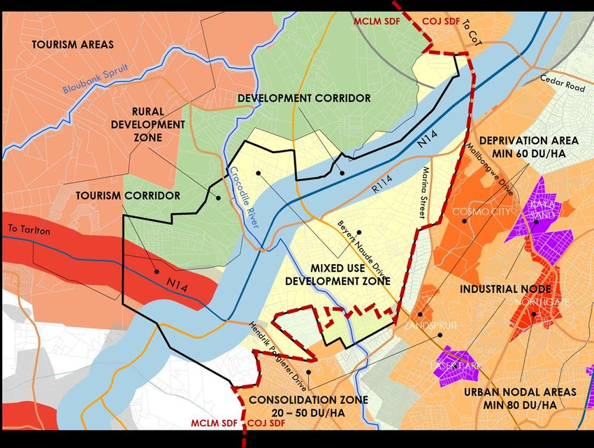
▪ The area to the north of the N14 is mostly
SPATIAL POLICY FRAMEWORKS
designated as a Rural development Zone and a
The West Rand District Spatial Development Framework, small section as a mixed-use development zone
2020 identifies three secondary nodes in the Muldersdrift ▪ The entire area to the south of the N14 is
Precinct: designated as a mixed-use development area.
▪ The future Lanseria-Nooitgedacht-Cosmo City ▪ Just outside of the north-eastern corner in the City
node towards the north at the intersection of Johannesburg is the Lanseria Special
between route Malibongwe Drive and the N14 Development Zone and its area of influence falls
freeway which is earmarked to become a future into this portion of the precinct.
metropolitan activity node comprising more than
33 000 residential units in the context of the City of The City of Johannesburg SDF proposes the
Joburg following:
▪ Muldersdrift in the central part of the N14 corridor ▪ Cosmo City and Zandspruit as Deprivation
in the vicinity of the Beyers Naude Drive areas with development proposed densities
intersection of a minimum of 60 du/ha
▪ Silver Star-Cradle Mall node at the intersection ▪ The Urban Nodal Areas (Randburg) with a
between route Hendrik Potgieter Drive and N14 minimum density of 80du/ha
▪ The remainder of the area is designated as a
In terms of the Mogale City Spatial Development
consolidation zone with a density of 20 –
Framework, 2019, the Muldersdrift Precinct is affected as
50du/ha.
follows:
▪ An industrial area is located along Beyers
▪ The N14 north of its intersection with Hendrik
Naude Drive and along Malibongwe Drive
Potgieter Road is defined as a Development
along which the node of Randburg is also
Corridor
located.
▪ The N14 to the west of its intersection with Hendrik
Potgieter Road is defined as a tourism corridor.
▪ A secondary node is proposed at the intersection
of the N14 and Hendrik Potgieter Road (at the
Cradlestone shopping centre) and at the
intersection of the N14 and the R114 (the Drift
node).
13
September 2020MULDERSDRIFT DRAFT PRECINCT PLAN
Figure 5: COMBINED MCLM AND CoJ MM SDFs
14
September 2020MULDERSDRIFT DRAFT PRECINCT PLAN
MACRO-ECONOMIC PROFILE 50,00%
43,45%
45,00%
The following are the salient points emanating from the 40,00%
socio-economic and market study for the sub-region: 35,00%
▪ The local economy experienced a positive economic 30,00%
25,00% 22,61%
growth with a 0.28% increase from 2017 to 2018 and a
20,00%
0.27% increase from 2018 to 2019.
15,00%
▪ Economic sectors that performed well in 2019 includes 8,89% 7,62% 8,41%
10,00%
Wholesale and retail trade with 3.64% growth, 4,46% 3,41%
5,00% 1,15%
Transport, storage and communication with 4.35% 0,00%
growth, Finance, insurance, real estate and business
Electricity, gas and water
Transport, storage and
Mining and quarrying
Manufacturing
Wholesale and retail trade,
Community, social and
estate and business services
Agriculture, forestry and
General government +
Finance, insurance, real
service with 4.98% growth and General Government +
personal services
communication
accommodation
Community, social and personal services with 1.45%.
catering and
fishing
▪ Economic sectors that have shown economic decline
includes: Agriculture (-7.25%), Mining and quarrying (-
9.47%), Manufacturing (-1.84%) and Electricity, gas
and water with a decline of 4.82% in 2019.
▪ The Finance, insurance, real estate and business
services sector makes the largest contribution of
43.45%, followed by the Manufacturing contributing
Figure 6: ECONOMIC SECTOR CONTRIBUTION SUBREGION1
22.61%. Wholesale and retail trade, catering and
accommodation contributes 8.89% to the economy From the economic spatial contribution below, there is a
followed by the General Government and clear indication where each economic sector is
Community, social and personal services sector, concentrated.
making a contribution of 8.41%.
1 Source: CSIR, Data provided by Quantec on Local Municipal disseminate to
mesozone level with Dasymetric map, 2020
15
September 2020MULDERSDRIFT DRAFT PRECINCT PLAN
Agriculture Forestry and Fisheries Mining and Quarrying Manufacturing
Wholesale and Retail Trade, Catering and Finance, insurance, real estate, and business General Government + Community, Social
Accommodation services and Personal Services
16
September 2020MULDERSDRIFT DRAFT PRECINCT PLAN
HOUSEHOLD PROFILE
▪ The majority of the Precinct (38.65%) fall within the low-
income band.
▪ There is a relatively high percentage in the Precinct
(13.85%) that earn no income.
▪ The largest portion of the population for the precinct
(32.62%) has some secondary education.
▪ The second largest portion of the population for the
Precinct (28.52%) completed matric. In addition, a fairly
large portion of the Precinct’s population (22.89%)
completed a higher degree.
▪ In the Precinct 50.95% of the population aged between
5 – 24 are attending ordinary school.
▪ The Precinct has an employment rate of 66.76%, with an
unemployment rate of 11.91%.
▪ The largest portion of the population within the Precinct
(40.98%) is skilled. With 28.83% in the Precinct classified
as low-skilled.
▪ The largest portion of the market area’s homes can be
classified rented, with 37.78% in the Sub Region and
36.65% in the Precinct.
17
September 2020MULDERSDRIFT DRAFT PRECINCT PLAN
Table 2: MULDERSDRIFT PRECINCT POPULATION AND HOUSEHOLD
POPULATION GROWTH FIGURES3
Approximately 39 665 people currently reside within the Muldersdrift
2020 2021 2022 2025 2030 2035
Muldersdrift Sub Region, comprising of 14 806 households Precinct
with an average household size of 2.6 people per Population 28 765 29 262 29 768 31 339 34 144 37 200
household. These figures are expected to increase to 51
Household 10 094 10 289 10 487 11 106 12 220 13 445
297 people and 19 722 households in the in the Sub
Region by the year 2035.
28 765 people currently reside within the Muldersdrift Population annual growth rate is 1.73% and household annual
Precinct, comprising of 10 094 households with an growth rate is 1.93%, an indication of more individuals entering
average household size of 2.8 people per household. the precinct rather than households. The population and
These figures are expected to increase to 37 200 people household profiles are based on data from the Census 2011
and 13 445 households in the Precinct by the year 2035. and Quantec. The population growth projections are based
on a five-year historic growth rate of 1.73% per annum and a
Table 1: MULDERSDRIFT SUB REGION POPULATION AND HOUSEHOLD
household growth rate of 1.93% for the precinct. The growth
FIGURES2
rates were applied to the population and household figures to
Muldersdrift Sub
2020 2021 2022 2025 2030 2035 project the future population growth utilising 2011 as the base
Region
year.
Population 39 665 40 351 41 049 43 215 47 083 51 297
Table 3: MULDERSDRIFT PRECINCT POPULATION AND HOUSEHOLD
Household 14 806 15 092 15 383 16 291 17 924 19 722 GROWTH4
201 201 201 201 201 201 201 201 5-Year
2 3 4 5 6 7 8 9 Average
Population (% 1,8 2,2 2,0 1,9 1,3 1,9 1,8 1,6
1,73%
Growth) 5% 0% 1% 1% 8% 0% 5% 1%
Households (% 2,1 2,4 2,2 2,1 1,6 2,0 2,0 1,7
1,93%
Growth) 2% 6% 6% 5% 0% 9% 3% 8%
2 Source: StatsSA Census 2011, Easydata via Quantec & Based on UE projections 4 Source: StatsSA Census 2011, Easydata via Quantec & Based on UE projections
3 Source: StatsSA Census 2011, Easydata via Quantec & Based on UE projections
18
September 2020MULDERSDRIFT DRAFT PRECINCT PLAN
60 000 40 000 37 200
51 297 34 144
35 000
50 000 47 083 31 339
43 215 28 765 29 262 29 768
40 351 41 049 30 000
39 665
40 000
25 000
30 000 20 000
19 722 15 000 13 445
17 924 11 106 12 220
20 000 14 806 15 092 15 383 16 291 10 094 10 289 10 487
10 000
10 000
5 000
0 0
2020 2021 2022 2025 2030 2035 2020 2021 2022 2025 2030 2035
Population Household Population Household
Linear (Population) Linear (Household) Linear (Population) Linear (Household)
Figure 7: SUB-REGION POPULATION GROWTH Figure 8: PRECINCT POPULATION GROWTH
19
September 2020MULDERSDRIFT DRAFT PRECINCT PLAN
the population is not fully served at the base year, the
RESIDENTIAL MARKET POTENTIAL
equilibrium model enables the calculation of the starting
The purpose of this sub-section is to illustrate the market point for the demand generation due to the
potential analysis for the proposed residential immeasurable supply and the large market area. For this
development. The gap for development in the market study, 2019 is used as the base year, which enables the
area is calculated using the Net Effective Demand (NED). determination of the bonded and rental housing
The NED indicates the potential of the local market to demand for 2020 onwards.
support additional development within its boundaries.
POPULATION PROFILE
Figure 9: Net Effective Demand Equation
The population profile presents the household and
population size within the delineated market area.
These figures were used as a basis for the equilibrium
demand model. Annual population and household
growth were calculated based on the five-year
average.
The demand model for the proposed development uses HOUSEHOLD INCOME
projections in population, the number of households, and This subsection provides a breakdown of the annual
income distribution trends to provide a quantitative household income of households located in both the
indication of demand. The market demand assessment Sub Region and Precinct areas. Based on the annual
considers the following important demand drivers: household income figures and population features,
▪ Growth in the number of households housing affordability ranges were calculated for both
▪ Household income rental and bonded housing to inform the level of
▪ Residential affordability affordability between the various income groups within
the market area.
METHODOLOGY
An equilibrium demand modelling technique is used, CUMULATIVE NET EFFECTIVE RESIDENTIAL
which assumes that the demand for bonded and rental DEMAND
housing in the market area is null in the base year (2019) The cumulative net effective residential demand is 4 420
as the local population is fully served in terms of bonded units in total. Table 4 and Table 5 indicate the
and rental accommodation. Although it is known that breakdown of the demand.
20
September 2020MULDERSDRIFT DRAFT PRECINCT PLAN
The cumulative net effective demand for bonded housing The cumulative net effective demand for the rental housing
within the Sub Region: within the Sub Region.
Table 4: CUMULATIVE NET EFFECTIVE DEMAND – BONDED Table 5: CUMULATIVE NET EFFECTIVE DEMAND – RENTAL
Affordable Middle High Social Social
YEAR Subsidised FLISP Total Affordab
Housing Income Income Housing Housing Middle High
YEAR CRU le Total
Primary Secondar Income Income
2020 338 137 38 71 53 637 Market y Market
Housing
2021 388 158 44 82 60 731 2020 113 184 86 54 101 75 613
2022 438 178 49 92 68 827 2021 130 211 99 62 116 85 703
2023 490 199 55 103 76 924 2022 147 239 112 70 131 97 795
2024 543 221 61 114 85 1024 2023 165 267 125 78 146 108 889
2025 597 243 67 126 93 1125 2024 182 295 139 87 162 120 985
2026 651 265 73 137 101 1229 2025 200 325 153 95 178 132 1 082
2027 707 288 80 149 110 1334 2026 219 354 167 104 194 144 1 182
2028 764 311 86 161 119 1441 2027 237 385 181 113 211 156 1 283
2029 822 334 93 173 128 1551 2028 257 416 196 122 228 168 1 386
2030 881 359 99 186 137 1662 2029 276 447 210 131 245 181 1 491
2031 942 383 106 198 147 1 776 2030 296 479 226 141 263 194 1 598
2032 1 003 408 113 211 156 1 892 2031 316 512 241 150 281 208 1 708
2033 1 066 433 120 224 166 2 010 2032 337 546 257 160 299 221 1 819
2034 1 129 459 127 238 176 2 130 2033 358 580 273 170 318 235 1 933
2035 1 195 486 135 252 186 2 253 2034 379 614 289 180 337 249 2 049
2035 401 650 306 191 356 263 2 167
21
September 2020MULDERSDRIFT DRAFT PRECINCT PLAN
Figure 10: HOUSING AFFORDABILITY RANGES
22
September 2020MULDERSDRIFT DRAFT PRECINCT PLAN
RESIDENTIAL DEVELOPMENT
DIFFERENT RESIDENTIAL TYPOLOGIES
Residential development in the Precinct differs in
character. The bulk of the Precinct is still agricultural in
nature.
Security estates dominate the N14/ Hendrik Potgieter
intersection and is growing at a rapid rate around the
Cradlestone Mall. 340ha of the Precinct is already used
for this type of development. It links in function and
typology more to the adjacent area of Ruimsig in
Johannesburg than to the surrounding character of the
Precinct.
Some of the properties along Hendrik Potgieter and the
southern portion of the N14 are still agricultural holdings.
These comprise 240ha of the Precinct. The agricultural
holdings are rapidly changing to commercial and
residential use.
There are a large number of informal settlements spread
out over the entire precinct.
23
September 2020MULDERSDRIFT DRAFT PRECINCT PLAN
Figure 11: RESIDENTIAL CHARACTER
24
September 2020MULDERSDRIFT DRAFT PRECINCT PLAN
Figure 12: DISTRIBUTION OF BUILT STRUCTURES
25
September 2020MULDERSDRIFT DRAFT PRECINCT PLAN
INFORMAL SETTLEMENTS With regards to upgrading and resettlement, the
The following informal settlements have been compiled settlements fall in the following categories:
from the District Informal Settlement Status – Covid ▪ Category A: Full Upgrading consisting of full
Interventions, which is the most comprehensive and up services, top structures, and formal tenure where
to date information available. appropriate, affordable, and viable
▪ Category B1: Interim basic services for Informal
There are 24 informal settlements within and directly settlements which are viable and appropriate for
surrounding the Precinct. These range in size from less formalisation, but not imminent
than 20 to more than a 1 000 units. The settlements are ▪ Category B2: Providing emergency basic services
distributed throughout the precinct with some clustering for settlements where long-term formalisation is not
around main roads. Most of the settlements have to be viable and/or appropriate, but relocation is not
relocated because some are located within the CoH urgent or possible
WHS or are too isolated and small to functionally form ▪ Category C: Relocation of informal settlements
part of the urban structure. There is a dire need not only due to urgent health or safety threats which
to provide housing but also to create a functional urban cannot be mitigated, and relocation sites are
form, where informal settlements can be integrated in readily available
the urban structure and functioning.
Figure 13: INFORMAL SETTLEMENTS
Settlement Locality Property Description Category Nr of Households
Portion 38 Nooitgedacht 534 North of N14 Pnt 38 of Nooitgedacht 534- C - imminent
JQ 55
relocation
Ptn 42/RE Nooitgedacht 534 South of N14 along R/ Pnt 42 of Nooitgedacht C - imminent
IQ Nooitgedacht Rd 534 -IQ 25
relocation
Nooitgedacht 534 IQ Portion West of Zandspruit Portion 89 of Nooitgedacht
89 534-JQ A - upgrading 232
Portion 81 Rietfontein 189 IQ North of N14 and east of Beyers Pnt 81 of Rietfontein 189-IQ B1 – long tern
Naude Dr 150
upgrading
26
September 2020MULDERSDRIFT DRAFT PRECINCT PLAN
Settlement Locality Property Description Category Nr of Households
Portion 44 Rietfontein North of N14 and east of Beyers Pnt 44 of Rietfontein 189-IQ C - imminent
Naude Dr 70
relocation
Portion 4 Rietfontein 189 IQ South of N14 and east of Beyers Pnt 4 of Rietfontein 189-IQ C - imminent
Naude Dr 112
relocation
Rietfontein Plot 83 and 90) South of N14 and east of Beyers Pnt 83 and 90 of Rietfontein B1 – long tern
Naude Dr 189-IQ 1 850
upgrading
Plot 78 Ethembalethu West of Beyers Naude Dr and Pnt 78 of Driefontein 179-IQ B2 – long term
north of N14 35
relocation
Plot 62 Driefontein (Sekolong) West of Beyers Naude (M5) Dr Pnt 62 of Driefontein 179-IQ C - imminent
and north west of N14 18
relocation
Rietfontein Plot 195 South of N14 and west of Pnt 195 of Rietfontein 189-IQ C - imminent
Beyers Naude Dr 24
relocation
Plot 77 Rietvlei South of N14 and west of Pnt 77 of Rietvallei 180-IQ C - imminent
Beyers Naude Dr 48
relocation
Plot 71 and 72 Driefontein West of Beyers Naude Dr and Pnt 71 and 72 of Driefontein
C - imminent
(Avianto) north west of N14. Along 179-IQ 16
relocation
Driefontein Rd
Rietfontein Plot 140 South of N14 and west of Pnt 140 of Rietfontein 189-IQ C - imminent
Beyers Naude Dr 90
relocation
Plot 45 Rietvlei East of N14 Pnt 45 of Rietvallei 180-IQ C - imminent
25
relocation
Plot 79 Rietvlei East of N14 Pnt 79 of Rietvallei 180-IQ
A - upgrading 93
Plot 34 Rietvlei East of the N14 Pnt 34 of Rietvallei 180-IQ C - imminent
35
relocation
Plot 8 Van Wyk Restant East of the N14 Pnt 8 of Van Wyks Restant C - imminent
182-IQ 34
relocation
Plot 33 Van Wyk Restant East of the N14 Pnt 33 of Van Wyks Restant C - imminent
182-IQ 20
relocation
Steynsvlei 41 North of the N14 Holding 41 of Steynsvlei AH C - imminent
20
relocation
Steynsvlei 24 North of the N14 Holding 24 of Steynsvlei AH C - imminent
40
relocation
27
September 2020MULDERSDRIFT DRAFT PRECINCT PLAN
Settlement Locality Property Description Category Nr of Households
Plot 63 Rietvlei East of the N14 Pnt 63 of Rietvallei 180-IQ C - imminent
43
relocation
Van Wyk's Restant 182 East of the N14 Re/ Van Wyks Restant 182- C - imminent
IQ 50
relocation
Portion 1 Ruimsig North of Beyers Naude Dr Erf 1 of Arena C - imminent
1 050
relocation
Plot 11 Honingklip North of the N14 Ptn 11 of Honingklip 178-IQ
A - upgrading 15
4 150
28
September 2020MULDERSDRIFT DRAFT PRECINCT PLAN
Figure 14: EXISTING INFORMAL SETTLEMENTS
29
September 2020MULDERSDRIFT DRAFT PRECINCT PLAN
HUMAN SETTLEMENT PROJECTS
Three subsidised housing projects have been completed. These are:
Table 6: SUBSIDISED HOUSING PROJECTS
Name Date of GP Proclaimed Estimate number of units Area
Dr Nthato Motlana 2015 2018 260 22 ha
Ethembalethu 2009 160 10.5 ha
Riefontein Village 2007 2017 213 30.9 ha
TOTAL 633 63.4ha
The following two housing projects are in different stages of implementation:
Table 7: PROPOSED HOUSING PROJECTS
Project Name Property Description Residential Typology Other facilities
Refentse Township (Mogale Portions 89, 90, 205, 206 and ▪ 1 926 Res 1 ▪ 2 Business 1 erven,
Ext 16) 370 Nooitgedacht 504-JQ ▪ Res 4 (64 - 80du/ha) ▪ 4 educational erven
▪ 3 Res 4 (500 du/ha) ▪ 2 Business 3 erven
▪ 5 institutional erven
▪ 4 POS
▪ 3 municipal erven
Honingklip Township Part of portion 11 Honingklip
218 Res 1 erven
178-IQ
TOTAL
30
September 2020MULDERSDRIFT DRAFT PRECINCT PLAN
Figure 15: EXISTING INFORMAL SETTLEMENTS
31
September 2020MULDERSDRIFT DRAFT PRECINCT PLAN
Table 8: DEMAND VS SUPPLY
HOUSEHOLD DEMAND AND SUPPLY
Nr of
According to the socio-economic study, there are DEMAND SUPPLY Nr of erven
households
currently 10 094 households in the precinct. This is Housing study – Refentse Township
NED sub-region 4 420 (Mogale Ext 16)
projected to grow to 13 445 households by the year 2035 2035
based on population growth trends over the past five Informal Honingklip
4 150 218
years. There are 14 806 households in the subregion settlements Township
projected to grow to 19 722 in 2035. Backyard units
(sub-region) 3 100
2020
The cumulative net effective demand (NED) for housing
is projected to grow by 4 420 households for the TOTAL 11 670 TOTAL
subregion.
There are currently approximately 4 150 households that
are residing in informal settlements in the subregion that
need to be accommodated.
The second most common dwelling typology is an
informal dwelling in a backyard, consisting of 14.48% in
the Sub Region and 21.14% in the Precinct (based on
census 2011). This accounts for some 3 100 units in the
subregion.
32
September 2020MULDERSDRIFT DRAFT PRECINCT PLAN
developments are of such a nature that each does not
NON-RESIDENTIAL DEVELOPMENT
warrant social facilities when considered on their own,
Being on the rural-urban fringe, a wide variety of different but their cumulative impact necessitates the provision of
non-residential uses are spread throughout the Precinct. a wide array of social facilities. The ideal is to cluster social
facilities together in an accessible node.
Retail development is specifically focused on the N14/
Hendrik Potgieter intersection with the Cradlestone Mall There is limited agricultural activity left in the Precinct.
creating the centre of the node. There is a There is a cluster of facilities along the western section of
concentration of particularly commercial development the N14. These are not strictly agriculture in nature but
at the intersection of Beyers Naude Drive, the R114 and rather activities such as nurseries.
the N14. Smaller retail and commercial clusters are
The main factors that inform the Precinct Plan with
located:
regards to land use is the gravitation of commercial and
▪ along the R114 between the intersection with
retail activities to main routes and intersections and
Beyers Naude Drive and its intersection with the
tourism towards the Cradle. The remainder of the
N14
Precinct has different, sometimes conflicting and illegal
▪ along Beyers Naude Drive on the eastern border
land uses, mixed together.
of the Precinct
▪ along the western section of the N14
The importance of visibility, accessibility, and many users
on the locational choices of business is clear.
Tourism facilities are distributed over the entire Precinct.
The only concentration can be identified along the R114
to the north of the N14. This is one of the main routes to
the Cradle of Humankind.
Social facilities are sparse and widely distributed. Long
distances must be travelled to access these facilities.
There is also a shortage of facilities. This will increase with
the development of lifestyle estates and the conversion
of agricultural holdings into residential complexes. These
33
September 2020MULDERSDRIFT DRAFT PRECINCT PLAN
Figure 16: NON-RESIDENTIAL FACILITIES
34
September 2020MULDERSDRIFT DRAFT PRECINCT PLAN
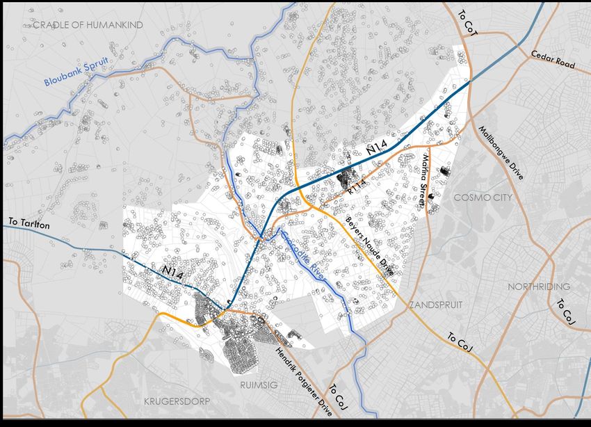
ROAD NETWORK
The N14 dominates the Precinct. It connects to the City
of Tshwane and Lanseria airport in the north and to the
R28 in the south. In the east, it connects to Hendrik
Potgieter Drive and to the west it continues past the
Precinct boundary to Tarlton.
The north-south stretch of the N14 has been designated
as a Development Corridor and the east-west stretch as
a Tourism Corridor.
There are three important linkages to the City of
Johannesburg:
▪ Malibongwe Drive which runs next to Cosmo City
and links to Strydom Park and Randburg
▪ Beyers Naude Drive which passes Zandspruit and
connects to Laser Park and Honey Dew
▪ Hendrik Potgieter Drive which links to Ruimsig and
Roodepoort.
All these routes are freight routes and carry large
numbers of traffic. Development is naturally attracted
to these routes, leading to an increase in the traffic
which creates significant pedestrian-vehicular traffic.
35
September 2020MULDERSDRIFT DRAFT PRECINCT PLAN
Figure 17: ROAD NETWORK
36
September 2020MULDERSDRIFT DRAFT PRECINCT PLAN
37
September 2020MULDERSDRIFT DRAFT PRECINCT PLAN
DEVELOPMENT CONCEPT
INTRODUCTION
The design concept explains the logic behind the
proposals for the future development of the Precinct.
STRUCTURING ELEMENTS
The structuring elements consist of environmental factors,
residential development, land use concentrations,
development zones and corridor and nodal
development.
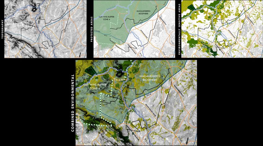
ENVIRONMENTAL FACTORS
The Precinct is relatively flat, except for the Roodepoort
Ridge which defines its southern border. The Crocodile
River that passes through the middle of the Precinct in a
north-south direction. It is classified as endangered.
The area to the west of the N14 and to the south and
north of the western leg of the N14 falls within the
Magaliesberg Biosphere and the Cradle of Humankind
World Heritage Site Buffer Zone 4 (Visual).
Environmentally sensitive and ecologically important
areas are focussed on the rivers and the ridges.
Development in the north-western portion of the site is
thus not ideally suited for development.
38
September 2020MULDERSDRIFT DRAFT PRECINCT PLAN
Figure 18: NATURAL FEATURES
39
September 2020MULDERSDRIFT DRAFT PRECINCT PLAN
DEVELOPMENT CORRIDOR
N14 is identified as a development corridor in the MCLM
SDF, 2019.
It should act as a magnet along which commercial
development can be attracted to by its high levels of
visibility and accessibility.
The development corridor is defined as 1km wide on
each side of the N14.
The N14 links with Lanseria airport and the City of Tshwane
in the north. Lanseria is seen as a significant growth point
along the lines of an aerotropolis and its area of influence
affects the northern part of the Precinct.
For the purpose of this Precinct Plan the corridor it ends at
the intersection with Hendrik Potgieter Road where it
Figure 19: N14 DEVELOPMENT CORRIDOR
crosses the Roodepoort Ridge.
40
September 2020MULDERSDRIFT DRAFT PRECINCT PLAN
There are four intersections on this stretch of the N14 that
falls within the Precinct:
1) Malibongwe Drive: full interchange
2) Beyers Naude: full interchange
3) R114/ Drift Boulevard: left-in left-out underpass
4) Hendrik Potgieter: at grade intersection
These are spaced as follows: 8km - 3km – 3km
In order for a development corridor to function properly it
needs a mobility spines (the N14) and supporting
accessibility spines on the sides to provide access to
development. The R114 functions as an accessibility
spine to the north of Beyers Naude on the southern side
of the N14. To the north of Beters Naude Drive, Sunset
Drive provides an acitivity spine although it is not well
linked. There are no other accessibility spines along the
remainder of the N14 to support the development Figure 20: ACCESSIBILITY SPINES ALONG THE N14
corridor. These must to be developed if the development
corridor is to developed successfully.
The dimensions of the development corridor will be
tapered to match the alignment of the R114 and Sunset
Drive.
41
September 2020MULDERSDRIFT DRAFT PRECINCT PLAN
ACTIVITY SPINES It would be ideal to have an activity spine to the north
The Precinct will be structured through the use of activity of the N14 and an extension of the R114 towards the
spines. Activity spines are accessibility routes with lined south on the side of the development corridor.
with mixed uses and high densities. Existing and The eastern leg of N14 is designated as a Tourism
proposed roads are used to create a loose grid. Corridor in the MCLM SDF, 2019. It links up with a network
The R114 is already functioning as an activity spine and of tourism corridors that connect Magaliesburg,
fulfil an important role as support accessibility spine for Hekpoort the Cradle of Humankind, Hartebeestpoort
the N14. It is proposed that this route becomes an Dam and Rustenburg. It currently does not have the
activity spine from its northern intersection with character of a tourism corridor in this area with vehicle
Malibongwe Drive to its southern intersection with the related land uses and few tourism offerings. Its
N14. It would be ideal if this link could be linked to character is that of a mixed-use spine at least to the
Hendrik Potgieter Drive in the south. It will have the western edge of the Precinct. A strategy needs to be
character of a retail mixed use spine. developed to create a tourism character along this
route. It is proposed that the first row of erven, be used
The three important linkages to Johannesburg: for tourism facilities. This ranges from 200m – 500m deep.
Malibongwe Drive, Beyers Naude Drive and Hendrik Due to its current mixed-use character, mixed land use
Potgieter Drive form important connectors that are are also supported
surrounded by mixed land uses, exhibiting the
characteristics of activity spines. These should be The R114 gives access to the Cradle of Humankind
strengthened. Marina Street also plays an important World Heritage Site and several of the tourism facilities in
role in this regard. the area. It also connects to the node, colloquially
known as the Drift node or the old Muldersdrift node
The proposed K56 has the potential to develop as an directly to the east of the N14. The heat map for land
activity spine in future thereby connecting the three uses, indicates that there is already a clustering of social
main routes to Johannesburg. facilities at this node and along the R114 as it enters the
Given their current and proposed characteristics Cradle. It should thus be considered as a tourist spine
Malibongwe and Beyers Naude Drives are proposed and included in the tourism network.
commercial mixed-use spines and Marina Drive and the
proposed K56 as residential mixed use activity spines.
42
September 2020MULDERSDRIFT DRAFT PRECINCT PLAN
Figure 21: PROPOSED ACTIVITY SPINES
43
September 2020MULDERSDRIFT DRAFT PRECINCT PLAN
The ideal road network consisting of corridors and spines
must be adapted to align with natural features and
large land uses in order to be implementable. The
following amendments are necessary:
The access road to the north of the N14 cannot be an
activity spine but only an access road due to the natural
character of this area as well as its proximity to the
Cradle of Humankind and the Magaliesberg biosphere.
The R114 cannot be extended to the south of the
Crocodile River as the area is environmentally sensitive.
This means that the Development Corridor can only
develop on the western side of the N14 in this section.
The K56 can in all likelihood not link between Beyers
Naude and Hendrik Potgieter Drives due to
environmental sensitivities and quarrying.
Figure 22: RATIONALISED ACTIVITY SPINES
44
September 2020MULDERSDRIFT DRAFT PRECINCT PLAN
NODES AND CONCENTRATIONS
Nodes are spaced through the Precinct at points of
highest accessibility to allow equal access to as many
residents as possible.
Nodes consist of a high concentration and intensity of
missed uses.
Four mixed-use nodes have been identified:
▪ The Cradlestone Mall node which is the most
prominent and developed node at the
intersection of the N14 and Hendrik Potgieter
Drive.
▪ The Drift node which stretches along the R114
from the Crocodile River in the south to the
Beyers Naude Intersection in the north.
▪ A node on the intersection of the R114 and
Marina Street.
▪ At the intersection of Malibongwe Drive and the Figure 23: NODES AND CONCENTRATIONS
N14.
An industrial/commercial node has been identified at
Greengate along Beyers Naude Drive.
45
September 2020MULDERSDRIFT DRAFT PRECINCT PLAN
RESIDENTIAL TYPOLOGIES AND DENSITIES
Residential development in this Precinct should in
general be high to accommodate the need for
housing, both within Mogale City and within the City of
Johannesburg, whilst protected the Cradle of
Humankind and Magaliesberg Biosphere. The following
densities are proposed:
▪ Within the mixed nodes and the mixed-use
corridors, the proposed density is 80 – 120 du/ha.
This will allow for densification of points of highest
access and the introduction of a viable public
transport network.
▪ Adjacent to the City of Johannesburg,
specifically adjacent to Marina Street between
the N14 and Beyers Naude Road, the proposed
density is 60 -80du/ha. This will be aligned with
the densities in Cosmos City and the proposed
densities in Zandspruit.
▪ The remainder of the Precinct south and east of Figure 24: RESIDENTIAL TYPOLOGIES AND DENSITIES
the N14 is earmarked for a density or 20 60du/ha.
This accommodates current development as
well as higher density development.
▪ All residential to the north and west of the N14
should be rural, i.e. not smaller than 1ha in extent.
46
September 2020MULDERSDRIFT DRAFT PRECINCT PLAN
47
September 2020MULDERSDRIFT DRAFT PRECINCT PLAN
48
September 2020MULDERSDRIFT DRAFT PRECINCT PLAN
WAY FORWARD
After the approval of the development concept as
contained in the precinct plan, the implementation plan
will be drafted. This will include:
▪ Development of design guidelines
▪ Identification of and elaboration on strategic plans
and sector plans/ strategies
▪ Guidance for LUMS
▪ Incentives and evaluation and monitoring system
49
September 2020You can also read