ŌTAKI TO NORTH OF LEVIN DETAILED BUSINESS CASE INTERCHANGE OPTION REVIEW - NZTA
←
→
Page content transcription
If your browser does not render page correctly, please read the page content below
ŌTAKI TO NORTH OF LEVIN DETAILED BUSINESS
CASE
INTERCHANGE OPTION REVIEW
PREPARED FOR WAKA KŌTAKI NZ TRANSPORT AGENCY
May 2020
This document has been prepared for the benefit of Waka Kotaki New Zealand Transport Agency. No
liability is accepted by this company or any employee or sub-consultant of this company with respect to its
use by any other person.
This disclaimer shall apply notwithstanding that the report may be made available to other persons for an
application for permission or approval to fulfil a legal requirement.

QUALITY STATEMENT
PROJECT MANAGER                                                                  PROJECT TECHNICAL LEAD

Jon England                                                                      Jamie Povall

PREPARED BY

J Povall

CHECKED BY

 S Blackmore

REVIEWED BY

 P Peet

APPROVED FOR ISSUE BY

 J England

 WELLINGTON
 Level 13, 80 The Terrace, Wellington 6011
 PO Box 13-052, Armagh, Christchurch 8141
 TEL +64 4 381 6700, FAX +64 4 473 1982

REVISION SCHEDULE
                                                                   Signature or Typed Name (documentation on file)
 Rev
                  Date         Description
 No.                                                                                                  Reviewed         Approved
                                                                Prepared by        Checked by
                                                                                                         by               by
                                                                                   Selwyn
 1           30 April 2020     First Draft                      Jamie Povall                          Phil Peet
                                                                                   Blackmore
                                                                                   Selwyn
 2           08 May 2020       Draft to Client Review           Jamie Povall                          Phil Peet       Phil Peet
                                                                                   Blackmore
                                                                                   Selwyn
 3           15 May 2020       Second Draft                     Jamie Povall                          Phil Peet       Phil Peet
                                                                                   Blackmore
             24 August                                          Selwyn
 4                             FINAL DRAFT                                         Phil Peet          Phil Peet       Phil Peet
             2020                                               Blackmore

                                         Stantec │ Interchange Option Review │ May 2020

     Status: Draft to Client Review │ Project No.: 310203848 │ Our ref: O2NL Interchange Options Report FINAL DRAFT UPDATED 2.docx
Waka KŌtaki NZ Transport Agency
 Ō2NL Interchange Option Review

CONTENTS
1.         Introduction ............................................................................................................................................... 2
2.         Purpose....................................................................................................................................................... 3
3.         Interchange forms / types ........................................................................................................................ 3
4.         Summary of the interchange assessment process ................................................................................. 6
5.         Identification of interchange principles and design requirements (Step 1)......................................... 7
5.1        Interchange principles .............................................................................................................................. 7
5.2        Interchange design requirements ............................................................................................................ 9
6.         Identification of interchange locations (Step 2) ................................................................................... 10
7.         Identification of interchange form / type (Step 3) ............................................................................... 17
8.         Ō2NL Highway access considerations................................................................................................... 18
8.1        Southern section ...................................................................................................................................... 18
8.2        Northern section ....................................................................................................................................... 18
9.         Summary of interchange location and forms / types .......................................................................... 19
10.        Recommendations and next steps ........................................................................................................ 22
10.1       Recommendations .................................................................................................................................. 22
10.2       Next steps ................................................................................................................................................. 22

LIST OF TABLES
Table 1 – Indicative interchange footprint dimensions ........................................................................................ 9
Table 2 - Interchange location long list and evaluation .................................................................................... 11
Table 3 – Interchange locations removed from further consideration ............................................................. 17
Table 4 – Favoured form / type for the short listed interchange locations ...................................................... 17
Table 5 – Summary of favoured interchange locations and forms / types ...................................................... 19

LIST OF FIGURES
Figure 1 – Preferred 300m corridor for the Ō2NL Highway ................................................................................... 2
Figure 2 – System interchange (Source: AGRD Part 4C) ...................................................................................... 4
Figure 3 – Service Interchange (Source: AGRD Part 4C) ..................................................................................... 5

     May 2020 │ Status: FINAL DRAFT │ Project No.: 310203848 │ Our ref: O2NL Interchange Options Report FINAL DRAFT UPDATED 2.docx
                                                                                Page 1
1.       Introduction
State Highway 1 (SH1) is New Zealand’s premier highway, but the section between Ōtaki and Levin
is afflicted by a number of serious safety, efficiency and resilience problems. The importance of
this section of SH1 is characterised by its function in connecting Wellington to the upper North
Island, where no other resilient route exists. It also provides an essential economic connection to
Palmerston North, the largest freight node in central New Zealand.
Therefore, Waka Kotahi NZ Transport Agency (Waka Kotahi) has been investigating potential
upgrades and new alignment options to address the issues with the existing SH1 route. In 2018, an
Indicative Business Case (IBC) was endorsed, which included endorsement for an offline highway,
from Taylors Road in the south to north of Levin (and bypassing Levin (the Project or Ō2NL
Highway), and a 300m corridor (the preferred corridor) for further investigation. This Project was
subsequently included in the NZ Upgrade Programme to “improve safety and access, support
economic growth, provide greater route resilience, and better access to walking and cycling
facilities”.
Waka Kotahi is now undertaking a Detailed Business Case (DBC) to refine the new highway
alignment, interchange locations / options, and local road connections for the preferred corridor
plus undertake scheme design and obtain funding approvals.
As set out in Figure 1 below, the preferred corridor is located to the east of State Highway 1 (SH1)
and State Highway 57 (SH57). In summary, heading north, the proposed new highway will extend
from the northern end of the Peka Peka to Ōtaki Highway (which is located approximately 2km
north of the Ōtaki township) and will re-connect into SH1 and SH57 to the north of Levin.

Figure 1 – Preferred 300m corridor for the Ō2NL Highway
At the completion of the IBC, it was identified that further development and assessment of
potential interchanges (and their forms / types) for the preferred 300m corridor would be one of
the first key activities needing to be undertaken when developing the DBC.
The IBC also identified that further option development and assessment would be required for
the Ō2NL Highway alignment and for any major changes to the local road network. The initial
development and assessment processes for these key project features are documented in
separate reports.

  May 2020 │ Status: FINAL DRAFT │ Project No.: 310203848 │ Our ref: O2NL Interchange Options Report FINAL DRAFT UPDATED 2.docx
                                                             Page 2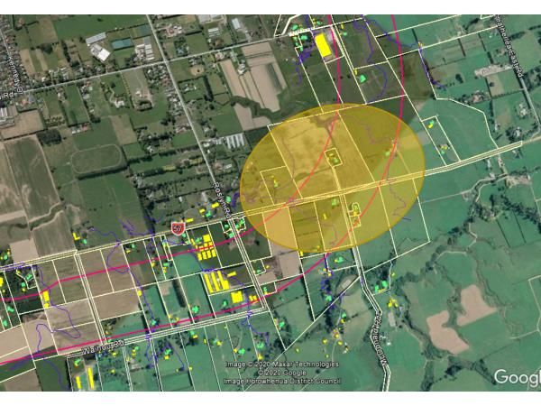
2.           Purpose
The purpose of this report is to set out the short-listed interchange location options that have
been recommended by the Design Team for further evaluation as part of the Ō2NL DBC’s multi
criteria assessment (MCA) process. This report also identifies the footprint sizes of the preferred
interchange options’ forms / types that are to be evaluated as part of the MCA process.

3.           Interchange forms / types
There are three types of interchange forms / types being considered for the Ō2NL Highway as
follows:
•      System interchange

•      Service interchange, and

•      At-grade roundabouts.

An overview of each interchange form / type is provided below. It is noted that the Design Team’s
recommendations for the interchanges are premised on both the initial NZ Transport Agency
design advice as well as Austroads’ Guide to Road Design (AGRD) Part 4C: Interchanges.
More detailed information on the interchange types can be found in the Ō2NL Design Philosophy
Report.

3.1.1        System interchanges
Typically, a system interchange would be provided at locations where a high standard
connection is required between high volume roads. Usually this would be in a “motorway-to-
motorway” type situation as set out in Figure 1. Layouts are typically based on the need to provide
for continuous high-speed traffic movements between motorways.                Consequently, large
interchange footprints are required in order to meet the necessary design requirements.
For Ō2NL, any system interchange is likely to be a T arrangement (rather than cross-roads). In this
type of situation, a bifurcation layout is often used, such as the SH1 / SH2 interchange at
Ngauranga, Wellington.
Generally, local access connections to and from system interchanges are avoided. This is
because mixing local traffic with free flow (through) traffic leads to inconsistency in form and a
lower level of road safety. If local access needs to be provided at a specific location it is usually
provided via service interchanges.1

1   Austroads Guide to Road Design Part 4C, Item 2.4.2

      May 2020 │ Status: FINAL DRAFT │ Project No.: 310203848 │ Our ref: O2NL Interchange Options Report FINAL DRAFT UPDATED 2.docx
                                                                 Page 3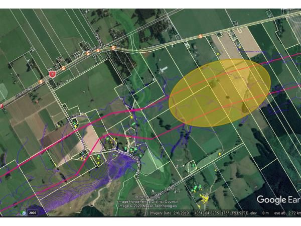
Figure 2 – System interchange (Source: AGRD Part 4C )

3.1.2      Service interchanges
Service interchanges are typically provided at locations where a state highway connects with the
local road network.
As set out in Figure 2, often service interchanges would likely take the form of elevated
roundabout or diamond shapes in order to provide access between state highways and local
roads. In non-urban situations, diamond shaped service interchanges tend to be preferred of
which there are several layout considerations including:
•    Full or half diamond shape: with ramps providing for all movements onto and off the local
     road, or only in one direction

•    Spread or compact diamond shape: a spread diamond is wider which allows the ramp
     connections to join the local road at ground level. For a compact diamond shape, the ramp
     intersection with the local road is elevated / lowered reducing the lateral spread of the
     interchange, and

•    Part-cloverleaf (‘Par-Clo’) options provide some connections in a cloverleaf type
     arrangement. Such arrangements often have less land requirements (when compared to the
     above interchange shapes).

    May 2020 │ Status: FINAL DRAFT │ Project No.: 310203848 │ Our ref: O2NL Interchange Options Report FINAL DRAFT UPDATED 2.docx
                                                               Page 4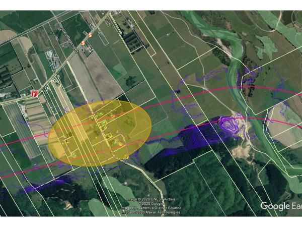
Figure 3 – Service Interchange ( Source: AGRD Part 4C )

Service interchanges often have significant footprints in order to operate safely, due to the need
to provide sufficient deceleration and acceleration distances for entering or exiting the high-
speed highway environment, at suitable horizontal and vertical geometric conditions.
3.1.2.1    Highway over local road, or vice-versa
A key consideration for service interchanges is whether the major road (e.g. highway) is to pass
over or under the minor road (e.g. local road) as this consideration impacts on the general form
of the interchange. Key considerations include:

•    Overall strategy – the grade of the major road may be determined by an overall requirement
     to have it completely depressed or completely elevated

•    Cost – the alternative arrangements (including the need for earthworks balance) needs to be
     considered when determining whether the major road is to go over or under. In general, it is
     more economical to have the major road constructed at existing ground level and to place
     the minor road over

•    Visual amenity – the main (through) road may be given preference by making it an overpass
     in order to take advantage of any vistas or to create a feeling of minimum restriction (although
     impacts on local viewshafts also need to be considered)

•    Operations – at interchanges, the operations of the ramps are assisted by having the major
     road at a lower level. This provides for the exiting traffic to slow down on the upgrade and the
     entering traffic to accelerate on the downgrade, which is a particular advantage for heavy
     commercial vehicles using the interchange ramps

•    Sight distance – in rolling topography, if there is no pronounced advantage in using either an
     overpass or an underpass, the interchange type that produces the best sight distance for the
     major road should be selected

•    Drainage – in some situations the choice of an underpass may create difficult drainage
     problems that would not arise if the major road was carried over the minor road with no
     changes to the grade line of the minor road

•    Constructability – if the new road is to be carried across a heavily trafficked road, an overpass
     will create the least disruption during construction

    May 2020 │ Status: FINAL DRAFT │ Project No.: 310203848 │ Our ref: O2NL Interchange Options Report FINAL DRAFT UPDATED 2.docx
                                                               Page 5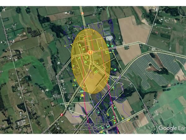
•    Over-dimension loads – on high load routes, an overpass has no limits on vertical clearance
     and may be the best solution. If the minor road passes over the major road, high loads may
     be accommodated on the ramps of the interchange if appropriately designed

•    Noise reduction – a road depressed below the surrounding area generally has a lower noise
     impact. Therefore, the road with the highest traffic will be better placed on the lower level

•    Constraint avoidance – different layouts may have different impacts on nearby constraints or
     sensitive receiving environments, and

•    Impact on walking and cycling routes – it may be preferable to avoid grade changes for these
     active modes which may be travelling alongside and/or across the main highway at
     interchange locations.

3.1.3      At-grade roundabout
As this is being designed as a highway, the only at-grade form that complies with the NZ Transport
Agency’s Safe System principles and AGRD Part 4B is a high standard roundabout. Typically, such
roundabouts comprise of a (minimum) 48m central island diameter 2, dual lane approaches, and
circulatory and departure lanes for an highway speed environment.
It is noted that the footprint for an at-grade roundabout is substantially less than that of an
interchange, but traffic performance is also lessened due to the conflicting movements between
side road and highway traffic, as well as the need for all highway traffic to be interrupted from
free flow through the roundabout.
Other than toward the northern extent and end of the highway, it is expected that at-grade
roundabouts may not be safe or appropriate ‘mid-point’ on the highway, given all other access
through to Wellington CBD is grade separated. This will require further testing through the MCA
and DBC progression.

4.         Summary of the interchange assessment process
In brief, in order to identify the preferred highway alignment, the following DBC processes are
being undertaken:
•    Step 1 – Identification of interchange principles and design requirements. This process was
     undertaken by the Design Team 3 with input from the NZ Transport Agency, Horowhenua
     District Council (HDC) and Iwi

•    Step 2 – Identification of a long list of interchange option locations

•    Step 3 – Assessment of the interchange long list options against the interchange principles.
     This process also enabled the likely form / type of the interchanges for each short-listed
     location to be narrowed down, which in turn enable the likely interchange footprint sizes at
     each location to be identified for further MCA assessment

•    Step 4 - Undertake an initial MCA process to identify the recommended interchange options
     and their preferred footprint sizes, with the outcomes to be documented in a Draft MCA
     Report

•    Step 5 - Undertake Iwi and public engagement on the outcomes of the initial MCA process

2 Austroads Guide to Road Design Part 4B: Roundabouts
3 The Design Team comprised of Jamie Povall (Design Manager), Phil Peet (Team Leader), and Selwyn Blackmore
(Transport Planning Lead)

    May 2020 │ Status: FINAL DRAFT │ Project No.: 310203848 │ Our ref: O2NL Interchange Options Report FINAL DRAFT UPDATED 2.docx
                                                               Page 6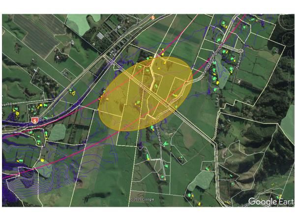
•    Step 6 - Following completion of Iwi and public engagement processes, review and update
     the MCA process and Draft MCA Report to identify the recommended interchange options,
     and

•    Step 7 - Recommend a preferred interchange option suite to the NZ Transport Agency for its
     consideration.

This report summarises the processes and recommendations of the Design Team for Steps 1, 2
and 3 above.

Following Step 3, the Design Team has identified a number of access considerations for the
southern and northern sections of the Ō2NL Highway. These considerations are documented
below in Section 8 of this report.

It is noted that the processes outlined in Steps 1 to 3 above are the long list evaluation steps
undertaken by the Design Team to help it identify a short list of interchange options to be taken
forward for MCA evaluation. The Design Team acknowledges that there may be a need to re-
visit its short list recommendations as a result of further project investigations and / or stakeholder
engagement.

5.         Identification of interchange principles and
           design requirements (Step 1)
5.1        Interchange principles
The purpose of determining interchange principles for the Ō2NL Highway is to help guide the
long to short list evaluation processes for the interchanges. Development of the principles has
been informed by the IBC / DBC investment objectives, and through initial discussions with HDC
and Tangata Whenua.
The Ō2NL interchange principles comprise of the following:
•    Current urban form

•    Potential future urban form

•    Technical considerations, and

•    Environmental and Cultural impacts.

A description of each principle is provided below.

5.1.1      Current urban form
The final interchange arrangement for the Ō2NL Highway needs to provide adequate access
between the existing state highway network and urban / peri-urban areas.
For access to areas of economic activity, particularly commercial and retail areas, th is principle
is about interchanges improving access to these areas where it is feasible to do so.
For all other areas, current trips should not be severely impacted by the new highway. For
example, increasing local trip lengths by more than 2 to 3km is considered undesirable, although
this may be necessary for some local community road users.
Good levels of service to communities and properties is to be achieved, including providing
improved access to strategic destinations. However, this could be provided by the existing
highway corridor (i.e. SH1 or SH57).

    May 2020 │ Status: FINAL DRAFT │ Project No.: 310203848 │ Our ref: O2NL Interchange Options Report FINAL DRAFT UPDATED 2.docx
                                                               Page 7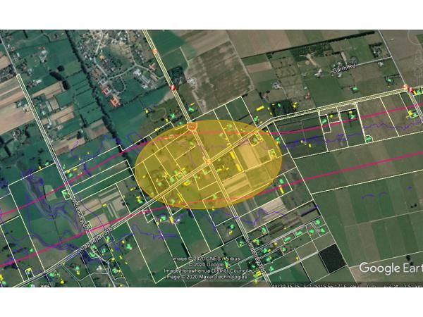
5.1.2      Potential urban form
Future areas of economic activity or residential growth, as defined by HDC strategies, need to
be considered when determining the final interchange arrangement (e.g. interchanges need to
cater for future transport demands). The same principles applying to the current urban form
(above) also apply when considering the likely urban form in 30+ years’ time.
It is noted that the initial form of the highway construction doesn’t necessarily need to cater for
forecasted transport demands, however any final interchange arrangement should be
appropriately “future proofed”. For example, the scheme may allow for an interchange to be
added later if predicted transport demands and the timing as to when this demand might be
realised indicates it isn’t warranted as part of the initial highway build.

5.1.3      Technical considerations
In general terms, the interchange designs need to be in keeping with the expectations of the road
user. They should be readable, and their form should be relatively consistent with other
interchanges along the corridor. Along the Wellington Northern Corridor, there are differing forms
/ types of service interchanges in operation. This in turn affords a certain level of flexibility when
considering / designing the interchanges to be built for the Ō2NL Highway.
Interchanges should be appropriately spaced to facilitate convenient access to and from the
state highway, but only where there is a demonstrable demand to do so. Not having an
interchange does not preclude other forms of local road connectivity across (but not to / from)
the highway such as over-bridges, underpasses or connections to other arterials or state highways.
In terms of spacing, the minimum spacing for interchanges should be between 5 and 8km in rural
areas4, although in urban areas this spacing distance can be reduced. There is no maximum
spacing. AGRD Part 4C also states that interchanges need to be located away from other
highway structures (e.g. major river crossings).
The interchanges for the Ō2NL Highway need to accommodate 110km/h design speeds, and
need to carefully manage the transition to lower local road speed environments (possibly 60km/h
for urban / peri-urban roads or up to 80km/h for rural local roads).
Overall, the final interchange arrangement needs to ensure that the layout will not result in
significant capacity or safety problems on the local road network (unless such issues are
addressed as part of the wider Ō2NL programme or by the specific interchange option).

5.1.4      Environmental and cultural impacts
The key anticipated environmental and cultural effects from the construction of the interchanges
to be considered for the Ō2NL Highway, include:
•    Noise effects (especially increased noise from vehicles on raised structures)

•    Visual impacts (e.g. due to the size and height of structures)

•    Community severance (e.g. access to and from property parcels and communities)

•    Other environmental (e.g. ecological effects), and

•    Cultural effects on sites of significance and also wider Tangata Whenua considerations.

Generally, environmental effects should be minimised whenever possible. As such, the Ō2NL
project has adopted a “tread lightly” design philosophy for the siting and design of the highway’s
interchanges (which is also expected to be a key principle that is embedded in the Ō2NL Urban

4Austroads Guide to Road Design Part 4C. Spacing of interchanges on the Wellington Northern Corridor range from
around 2.5km to 10km

    May 2020 │ Status: FINAL DRAFT │ Project No.: 310203848 │ Our ref: O2NL Interchange Options Report FINAL DRAFT UPDATED 2.docx
                                                               Page 8
Landscape Design Framework). This is to include minimising the footprints and / or visual effects
of the interchanges.
5.2 Interchange design requirements
The key interchange design requirements for the Ō2NL Highway include:
• Suitable separation between interchanges and other significant structures
• Direct impacts on well established residential / commercial areas are to be avoided if
possible
• Interchanges need to connect to an existing road (and the existing road ideally should be of
a standard and function that it serves a reasonable community catchment), and
• Interchanges are generally not to be located where ramp entry and exits would be on tight
horizontal curves, and
• Interchanges need to be safe for all modes.
5.2.1 Wellington Northern Corridor
The interchange arrangements for the Wellington Northern Corridor through to central Wellington
(i.e. the Terrace Tunnel) consist of various types of grade separated interchanges. These
interchanges take the form of either diamond or half diamond (service interchange) shapes.5 As
such, the interchange forms / types to be pursued for the Ō2NL Highway should ideally be in
keeping with the existing (and / or partially completed) Wellington Northern Corridor
interchanges.
5.2.2 Indicative interchange footprints
On the basis of the Design Team’s initial concept work, the relevant technical standards /
guidance and examples of other interchanges along the Wellington Northern Corridor / SH1, the
Design Team identified indicative / approximate dimensions for the footprints to help guide its long
list evaluation processes. These dimensions are set out in Table 1 below.
Table 1 – Indicative interchange footprint dimensions
Interchange forms / types Indicative footprint dimensions*
• 1500m length
Diamond (service interchange)
• 500m width
• 750m length
Half Diamond (service interchange)
• 500m width
• 1.5km length
Bifurcation (system interchange)
• 500m width
• 200m length
At-grade roundabout
• 200m width
*Excludes any associated local road realignment, shared use path or stormwater requirements
It is noted that final interchange footprint dimensions will vary from those identified above in Table
1 as a consequence of further investigation works, local constraints and desires and more
advanced 3D design. However, these dimensions were used to assist with location identification.
5The exception to this is the Central Wellington SH1/SH2 bifurcation split, as well as the bifurcation currently under
construction for Transmission Gully at Linden
May 2020 │ Status: FINAL DRAFT │ Project No.: 310203848 │ Our ref: O2NL Interchange Options Report FINAL DRAFT UPDATED 2.docx
Page 96. Identification of interchange locations (Step 2)
Based on the interchange principles and design requirements, the Design Team identified a long
list of interchange location options (relative to the 300m wide corridor). It then undertook a
high-level evaluation of each location option against the interchange principles.
The long list of interchange options and the Design Team’s interchange principle evaluations are
summarised in Table 2 below.
May 2020 │ Status: FINAL DRAFT │ Project No.: 310203848 │ Our ref: O2NL Interchange Options Report FINAL DRAFT UPDATED 2.docx
Page 10Table 2 - Interchange location long list and evaluation
Interchange principles evaluation
Overall
Interchange location6 Environmental
Current urban Future assessment
Technical and cultural
form urban form
impacts
Likely to be
located on a
Likely to be Likely to sub-optimal
used by the serve curve alignment Likely to have a
Manakau growth in large footprint
Manakau Interchange Consider
community, the and adversely
South traffic would further
including Manakau impact on local
Manakau Heights need to cross communities
Heights area rail line to
connect with
SH1
Avoids
interchange
Would be
traffic crossing Limited impacts
located
rail line to on local
some Likely to connect back dwellings
distance from serve to SH1
Manakau residential future Impacts on high Consider
North areas Manakau Complex design productivity further
growth requirements to land
Unlikely to be
areas reconnect local
well used by Impacts on
roads
Manakau Maori land
residents Close to
Waikawa stream
crossing (adds
6 Aerial maps are sourced from Google Earth (with design information overlaid)
May 2020 │ Status: FINAL DRAFT │ Project No.: 310203848 │ Our ref: O2NL Interchange Options Report FINAL DRAFT UPDATED 2.docx
Page 11Interchange principles evaluation
Overall
Interchange location6 Environmental
Current urban Future assessment
Technical and cultural
form urban form
impacts
design
complexity)
Highly unlikely
to meet state
highway or
local Not Would be in
connectivity located Poorly served by
close proximity
demands at near any Kuku East Road. Remove
to sensitive
Kuku this location residential Close to new from
foothills
Not well or Ohau river considerati
industrial crossing Significant on
placed to
growth impacts on
service
areas Maori land
existing
Manakau or
Ohau
communities
May 2020 │ Status: FINAL DRAFT │ Project No.: 310203848 │ Our ref: O2NL Interchange Options Report FINAL DRAFT UPDATED 2.docx
Page 12Interchange principles evaluation
Overall
Interchange location6 Environmental
Current urban Future assessment
Technical and cultural
form urban form
impacts
Inadequate
local road
Would connections
provide Very close to
Would not limited the major Ohau
Remove
provide access to River structure Located within
from
Muhunoa adequate southeast and is therefore Ohau River’s
considerati
access to Levin and likely to be flood zone
on
Levin centre industrial problematic
growth from a
areas geometric
perspective
Provides
moderate Regionally
level of significant
access to the Would Proximity of 4- ornate skink
Levin urban serve arm intersection identified in
area, but residential (Arapaepae / area
away from /industrial Kimberley) Consider
Kimberley the town poses complex Some dwellings
growth further
centre design located in close
areas to
challenges proximity
Kimberley southeast
Road (east of of Levin Adjacent to
SH57) serves area of flooding
only a limited risk
area
May 2020 │ Status: FINAL DRAFT │ Project No.: 310203848 │ Our ref: O2NL Interchange Options Report FINAL DRAFT UPDATED 2.docx
Page 13Interchange principles evaluation
Overall
Interchange location6 Environmental
Current urban Future assessment
Technical and cultural
form urban form
impacts
Proximity of SH57
could be
problematic
Likely to Would
provide good serve Intersection of
level of residential SH1/Tararua is
access to the /industrial substandard No extraordinary Consider
Tararua and requires
Levin urban growth issues identified further
area, and its areas to upgrade
key industrial southeast (changes to the
growth area of Levin North Island
Main Trunk Rail
Line crossing
also required)
Added design
complexity due Possible
to close significant
Would proximity of impacts on
Would native bush
serve SH57 (e.g. would
provide good area and
residential create speed, Remove
level of historic Prouse
Queen /industrial sight distance from
service to homestead.
Street growth and intersection considerati
urban and
areas to control issues). A number of on
southeast
southeast Very narrow dwellings in
Levin
of Levin corridor at this close proximity
location. impacted
Very close to
likely “SH1/57
May 2020 │ Status: FINAL DRAFT │ Project No.: 310203848 │ Our ref: O2NL Interchange Options Report FINAL DRAFT UPDATED 2.docx
Page 14Interchange principles evaluation
Overall
Interchange location6 Environmental
Current urban Future assessment
Technical and cultural
form urban form
impacts
split”
connection
Added design
Would Could complexities if
provide provide local roads
access to directly Potential
access to
Levin connected adverse visual
urban Levin
growth and noise
“SH1 / 57 and access Potential to Consider
areas and impacts in the
Split” north to retain SH57 in further
access existing rural
Sanson / current form
north to environment
Palmerston without
North Palmersto
deviation
n North
(growth) Localised
flooding issues
May 2020 │ Status: FINAL DRAFT │ Project No.: 310203848 │ Our ref: O2NL Interchange Options Report FINAL DRAFT UPDATED 2.docx
Page 15Interchange principles evaluation
Overall
Interchange location6 Environmental
Current urban Future assessment
Technical and cultural
form urban form
impacts
Would
provide Added design
Would access to complexity due
provide good Levin to close
levels of growth proximity to rail
North line No extraordinary Consider
access to areas and
Levin issues identified further
urban Levin access to
and to the the Needs to
north northern integrate with
growth local roads
areas
May 2020 │ Status: FINAL DRAFT │ Project No.: 310203848 │ Our ref: O2NL Interchange Options Report FINAL DRAFT UPDATED 2.docx
Page 16As set out in Table 2 above, the Design Team identified that interchange locations at Kuku,
Muhunoa and Queens Street would not meet the interchange principles, and therefore should
be removed from further consideration. The reasons for their removal are summarised in Table 3
below.
Table 3 – Interchange locations removed from further consideration
Interchange
Summary of key reasons for removal
Location
1. There is little existing local connectivity demand or need for an
interchange at this location and it is not close to future growth areas
Kuku 2. Likely to involve environmental / cultural / terrain complexities (which
could create increased cost, property acquisition relationship and
consenting risks)
1. Due to location it would be the primary access point to Levin from
the south, however it would provide a poor level of service for Levin
Muhunoa and to Horowhenua’s future residential / industrial growth areas
2. Very close proximity of major structure required for Ohau River
1. Corridor constraints here are significant (Prouse historic homestead
native bush and SH57)
Queen Street
2. Does not support the access requirements being pursued by HDC for
central Levin or for the Gladstone Green development
7. Identification of interchange form / type (Step 3)
Following removal of the Kuku, Muhunoa and Queens Street interchange locations, the Design
Team assessed the form / type of interchanges that were likely to be needed at the remaining
six interchange locations. The prime purpose of undertaking this assessment was to identify the
likely interchange footprint sizes that would need to be assessed through the MCA evaluation
process.
The forms / types of interchanges for the short-listed interchange locations favoured by the
Design Team are set out in Table 4 below. The footprint sizes for each form / type of interchange
are provided in Table 1 above.
Table 4 – Favoured form / type for the short listed interchange locations
Location Service Interchange System Interchange At-grade roundabout
Consider further Not required as there is Consider further
no need for a high-
Manakau
speed standard
South
connection at this
location
Consider further Not required as there is Consider further
no need for a high-
Manakau
speed standard
North
connection at this
location
Consider further Not required as there is Consider further
no need for a high-
Kimberley speed standard
connection at this
location
May 2020 │ Status: FINAL DRAFT │ Project No.: 310203848 │ Our ref: O2NL Interchange Options Report FINAL DRAFT UPDATED 2.docx
Page 17Consider further Not required as there is Consider further
no need for a high-
Tararua speed standard
connection at this
location
SH1 / 57 Split Consider further Consider further Consider further
Consider further Not required as there is Consider further
no need for a high-
North Levin speed standard
connection at this
location
8. Ō2NL Highway access considerations
Following on from the above analysis, there are still a number of decisions that need to be made,
either via the MCA process or in subsequent analysis. This section of the report outlines these
decisions.
8.1 Southern section
For the southern section of the Ō2NL Highway, the key access / local community connectivity
requirements needing to be considered as part of the MCA process are as follows:
1. Provision of a service interchange or at-grade roundabout to the north of Manakau only, or
2. Provision of a service interchange or at-grade roundabout to the south of Manakau only, or
3. No direct highway access, rather the design of the highway could be “future proofed” for
either a service or at-grade roundabout interchange north or south of Manakau (it is noted
that north and south bound access to and from the proposed revoked SH1 would be
provided at the Peka Peka to Ōtaki access arrangement to the north of the Ōtaki township).
Based on existing and future transport demands and community access requirements for the
southern section, there only needs to be one interchange provided (i.e. either to the north or
south of Manakau). It is noted that Austroads 7 recommends that rural interchanges should be
spaced a minimum of 5 to 8km apart. It is further noted that the potential locations 8 for
Manakau interchange options are all within an extent of 5km.
Transport modelling indicates there is unlikely to be sufficient existing transport / connectivity
demand for a Manakau interchange in the short to medium term. As such, providing no direct
access to the highway (but potentially future proofing its design) is an important access
consideration for the southern section of the highway.
8.2 Northern section
For the northern half of the Ō2NL Highway, the key access decisions that need to be considered
as part of the MCA process are as follows:
1. Whether an interchange should be provided at Tararua or Kimberley (not both)
2. The form of the interchange (service or at-grade roundabout) to be provided at Tararua or
Kimberley (depending on the above decision)
3. The form of interchange (system, service or at-grade roundabout) at the SH1 / SH57 split
7 Austroads Guide to Road Design Part 4C Interchanges
8 The area under consideration was South Manakau Road to the area to the immediate north of Waikawa Stream
May 2020 │ Status: FINAL DRAFT │ Project No.: 310203848 │ Our ref: O2NL Interchange Options Report FINAL DRAFT UPDATED 2.docx
Page 184. The form of interchange (service or at-grade roundabout) on SH1 to the north of Levin, and
5. Whether interchanges are required in all three locations.
9. Summary of interchange location and forms /
types
Table 5 below summarises the interchange locations and forms / types favoured by the Design
Team to be taken forward for further evaluation in the MCA process.
Table 5 – Summary of favoured interchange locations and forms / types
Interchange locations Interchange forms / types
Manakau Service Interchange and At-
South grade roundabout
Manakau Service Interchange and At-
North grade roundabout
May 2020 │ Status: FINAL DRAFT │ Project No.: 310203848 │ Our ref: O2NL Interchange Options Report FINAL DRAFT UPDATED 2.docx
Page 19Interchange locations Interchange forms / types
Service Interchange and At-
Kimberley
grade roundabout
Service Interchange and At-
Tararua
grade roundabout
Split System Interchange
SH1 / 57 (bifurcation), Service
Split interchange and At-grade
roundabout
May 2020 │ Status: FINAL DRAFT │ Project No.: 310203848 │ Our ref: O2NL Interchange Options Report FINAL DRAFT UPDATED 2.docx
Page 20Interchange locations Interchange forms / types
North Service interchange and At-
Levin grade roundabout
May 2020 │ Status: FINAL DRAFT │ Project No.: 310203848 │ Our ref: O2NL Interchange Options Report FINAL DRAFT UPDATED 2.docx
Page 2110. Recommendations and next steps
10.1 Recommendations
This report’s recommendations are as follows:
• NZ Transport Agency to confirm whether at-grade intersections are appropriate for the
Ō2NL Highway environment
• complete traffic modelling
• agree the short-listed interchange location options that are favoured by the Design Team,
be taken forward for further consideration in the MCA evaluation process
• agree that the footprint sizes of the preferred interchange options’ forms / types that are
favoured by the Design Team, be taken forward for further consideration in the MCA
evaluation process
• the interchange location options that have not been supported by the Design Team for
further investigation / evaluation be removed from further consideration.
It is acknowledged that the recommendations from this report may need to be reviewed and /
or amended as more information comes to hand during the MCA and consultation processes.
10.2 Next steps
If this report’s recommendations are approved, the next step for the Design Team will be to take
forward the short-listed interchange location options into the next phase of the MCA evaluation
process. This evaluation would include assessing the footprint sizes of the preferred interchange
options’ forms / types that have been favoured by the Design Team.
May 2020 │ Status: FINAL DRAFT │ Project No.: 310203848 │ Our ref: O2NL Interchange Options Report FINAL DRAFT UPDATED 2.docx
Page 22Wellington
Level 13, 80 The Terrace
Wellington 6011
PO Box 13-052, Armagh
Christchurch 8141
Tel +64 4 381 6700
Fax +64 4 473 1982
Please visit www.stantec.com to learn more about how
Stantec design with community in mind.You can also read