UPPER LAS VEGAS WASH CONSERVATION TRANSFER AREA: A SYSTEM TO DEVELOP ALTERNATIVE SCENARIOS
←
→
Page content transcription
If your browser does not render page correctly, please read the page content below
UPPER LAS VEGAS WASH
CONSERVATION TRANSFER AREA:
    A SYSTEM TO DEVELOP
   ALTERNATIVE SCENARIOS

             i
UPPER LAS VEGAS WASH
CONSERVATION TRANSFER AREA:
    A SYSTEM TO DEVELOP
   ALTERNATIVE SCENARIOS

    PREPARED FOR THE LAS VEGAS
   BUREAU OF LAND MANAGEMENT

          FEBRUARY 2007

                i
UTAH STATE UNIVERSITY TEAM

           Janis L. Boettinger
    Assistant Department Head and
   Associate Professor of Plants, Soils,
          and Biometeorology

              Glen Busch
            Project Manager

               Amy Croft
        Ph.D. Candidate, Biology

         Thomas C. Edwards, Jr.
    Professor of Wildland Resources;
        Research Ecologist, USGS

             Brian Jennings
       Ph.D. Candidate, Sociology

           Richard S. Krannich
   Department Head and Professor of
Sociology, Social Work, and Anthropology

            Ellie Leydsman
  M.S. Candidate, Bioregional Planning

         James A. MacMahon
      Trustee Professor of Biology;
     Director of the Ecology Center

             Richard E. Toth
  Professor of Environment and Society

                     ii
TABLE OF CONTENTS
Preface.......................................................................................................................................1
Introduction..............................................................................................................................5
Alternative Components..........................................................................................................6
Paiute Indian Reservation..................................................................................................7
Northwest Upper Las Vegas Wash..................................................................................12
Recreation and Public Purpose Lands............................................................................16
Southeast Upper Las Vegas Wash...................................................................................19
Mountain Edge Beltway ...................................................................................................25
References...............................................................................................................................28
iiiPREFACE
The Las Vegas Valley is located in southern Clark
County, Nevada within the Mojave Desert Ecoregion
of the Basin and Range Province. The Mojave Desert
is an expansive region in the arid western United
States spanning southeastern California and southern
Nevada (Figure 1). The low elevations of the Mojave
Desert create warm year-round temperatures with the
number of frost-free days greater than 200. Rainfall in
the Mojave Desert is scarce and averages less than six
inches (15.24 cm) per year. The average precipitation
in Las Vegas, Nevada is 4.13 inches (10.49 cm). The
limited precipitation in the Mojave Desert promotes
unique vegetation communities characterized by low,
widely spaced shrubs with numerous species of cacti,
yucca, and flowering annuals. The creosote bush-
dominated communities of southern Nevada provide
habitat for several species of reptiles, birds, and mam-
mals (MacMahon, 1985; Rundel and Gibson, 1996). Figure 1. The Nature Conservancy Mojave Desert Ecoregion.
The Las Vegas Valley is one of the fastest growing As a result of rapid urbanization and previous legisla-
regions in the United States and is continuing to grow tion mandating the disposal of Federal lands in the
at unprecedented rates with the remaining parcels of Las Vegas Valley, BLM managed lands have become
private land being converted to urban land uses to ac- widely separated and surrounded by more urbanized
commodate the growing population. The combined land uses. To address issues associated with the need
population of the North Las Vegas and Las Vegas mu- for developable lands and the management of public
nicipalities more than doubled from 306,003 in 1990 lands, Congress passed the Southern Nevada Public
to 721,822 in 2005. The population of Clark County Land Management Act (SNPLMA) in 1998 (Public
increased from 741,459 in 1990 to 1,710,551 in 2005 Law 105-263). The SNPLMA authorized the Bureau
(Figure 2) (United States Census Bureau). of Land Management to dispose of federal lands in
POPULATION CHANGE (1950 - 2005)
1,800,000
1,600,000
1,400,000
POPU L ATION
1,200,000
North Las Vegas
1,000,000
Las Vegas
800,000
Clark County
600,000
400,000
200,000
0
50
60
70
80
90
00
05
19
19
19
19
19
20
20
YEAR
Figure 2. Population Change in North Las Vegas City, Las Vegas City, and Clark County, Nevada (U.S. Census Bureau).
1PREFACE
Clark County, Nevada consistent with population east, the Desert National Wildlife Refuge to the north,
growth and community land-use plans and policies. In and Red Rock Canyon National Conservation Area
2002, the Clark County Conservation of Public Land and the Las Vegas Paiute Indian Reservation to the
and Natural Resources Act (Public Law 107-282) west (Figure 4).
amended the SNPLMA to expand the disposal bound-
ary area to address the continuing increase in growth
in the Las Vegas region.
The disposal boundary established by the Southern
Nevada Public Land Management Act of 1998 as
amended by the Clark County Conservation of Public
Land and Natural Resources Act of 2002 encompasses
the Las Vegas Valley in southern Clark County, Ne-
vada. The public lands that became available for auc-
tion were predominantly located in the northern and
southern portions of the disposal area. This project
and preliminary alternative future analyses focus on
the lands available for disposal in the north (Figure 3).
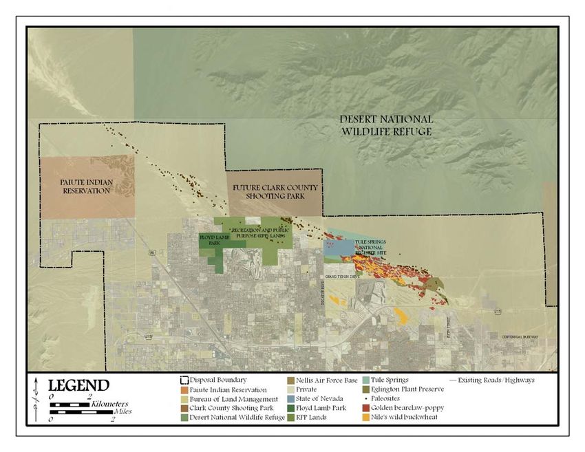
The northern area encompasses the Upper Las Vegas
Wash and is bordered by Nellis Air Force Base to the Figure 3. Disposal Boundary, Clark County, Nevada.
Figure 4. Upper Las Vegas Wash Conservation Transfer Area.
2PREFACE
While the Bureau of Land Management has been au- (Affected Environment) indicates that during a Class
thorized to dispose of lands within Clark County con- III field inventory, archeologists identified 100 sites,
sistent with population growth and community land- both prehistoric and historic, within the disposal area,
use plans, they are bound by other Federal legislation 69 of which were not previously recorded.
which has prevented the immediate auction of lands
within the Upper Las Vegas Wash. The American Antiquities Act of 1906 (16 USC 431-
433) seeks to protect historic and prehistoric ruins,
The Endangered Species Act of 1973 (16 USC 1531- monuments, objects of antiquity and scientific interest
1543) provides for the conservation of critical habitat on lands owned or controlled by the Government of
and ecosystems upon which threatened and endan- the United States by imposing misdemeanor-level
gered species depend on for survival and continued criminal penalties. The National Historic Preservation
existence. The Bureau of Land Management is also Act of 1966 (16 USC 470) created the National Regis-
required to protect candidate, proposed, and sensitive ter of Historic Places which extends protection to his-
plant species. Within the Upper Las Vegas Wash, toric places of State, local, and national significance.
there are two rare plant species, the Golden bearclaw- This legislation protects Tule Springs National Regis-
poppy (Arctomecon californica Torrey and Frémont) ter Site, an archeological site which has produced sub-
and Nile’s wild buckwheat (Eriogonum corymbosum stantial data relevant to the environmental history of
Bentham var. nilesii Reveal), both of which are listed the Great Basin. The Archaeological Resources Pro-
as sensitive species by the BLM. The Golden bear- tection Act of 1979 (16 USC 470a-11) provides for
claw-poppy is classified as critically endangered by the protection of archaeological resources on federal
the State of Nevada and Nile’s wild buckwheat is a lands by invoking felony-level penalties for excavat-
candidate for listing on the State of Nevada’s critically ing, removing, damaging, or defacing any archeologi-
endangered plant species list. Declines in the popula- cal resources older than 100 years on public or Indian
tion of these two species is largely attributed to the lands.
conversion of habitat for urban land uses, off-road
vehicle use, flood control infrastructure, road and util- Paleontological resources are fossilized evidence of
ity corridors, trash dumping, and gypsum mining past life on Earth. Review of the Las Vegas Disposal
(Morefield, 2001). Boundary EIS (Affected Environment) indicates that
438 previously unrecorded paleontological resources
There are several animal wildlife species which are were identified within the disposal boundary, the ma-
listed as sensitive by the BLM, some of which are jority of which reside in fossiliferous Quaternary
protected by the State of Nevada. Of critical concern spring deposits in the Upper Las Vegas Wash. Al-
is the threatened desert tortoise (Gopherus agassizii). though there is not a great deal of specific legislation
The desert tortoise inhabits a range of desert environ- protecting fossils other than what has been previously
ments in the southwestern United States, including discussed, the Fossil Preservation Act of 1996 (HR
southeastern California and southern Nevada. Al- 2943) provides for the protection, including the col-
though the BLM (Las Vegas Valley Disposal Bound- lection and preservation, of fossils that are on Federal
ary EIS) indicates that there is no designated critical lands for the present and future benefit of the people
habitat within the disposal boundary, the habitat of the of the United States. This legislation is controversial
desert tortoise encompasses Mojave Desert creosote because it encourages preservation through collection
bush scrub, thorn scrub, and cacti, specifically in in order to reduce the loss of fossils resulting from
sandy or gravelly locations. Washes, canyon bottoms, erosion and theft.
and oases also serve as habitat for the desert tortoise
(MacMahon, 1985). The Las Vegas Paiute Tribe Reservation is located
within the disposal area; therefore, other legislation
Cultural resources within the disposal boundary are that is relevant is the American Indian Religious Free-
protected by the American Antiquities Act of 1906, dom Act of 1978 and the Native American Graves
the National Historic Preservation Act of 1966, and Protection and Repatriation Act. The American Indian
the Archaeological Resources Protection Act of 1979. Religious Freedom Act of 1978 (42 USC 1996)
Review of the Las Vegas Disposal Boundary EIS protects and preserves the inherent right of Native
3PREFACE
Americans to believe, express, and exercise their tra-
ditional religions, including access to religious sites.
The Native American Graves Protection and Repatria-
tion Act of 1990 (25 USC 3001) establishes the right
of Indian tribes to claim ownership of certain cultural
items, including human remains and funerary, sacred,
and cultural patrimony objects and artifacts.
4INTRODUCTION
The primary objective of this deliverable was to de- A DVD containing an ArcGIS map document and the
velop a range of reasonable alternative scenarios using GIS shapefiles of the components is provided so alter-
the best professional judgment of our team prior to the natives can be composed by the Bureau of Land Man-
completion of the field work and the acquisition of the agement and stakeholders within the Las Vegas Val-
social and demographic survey results. There are chal- ley.
lenges with generating solid conclusions without the
evaluation of field data and social survey results; The GIS data used to create the base layers on the
therefore, the team developed a modular approach for maps was provided by the Las Vegas Bureau of Land
developing alternative scenarios. The components Management. Aero-Graphics provided the 2-foot reso-
within each module were delineated based on the lution 2005 aerial photography.
available data and some preliminary field work, and
they were constructed in such a way that they can be
modified based on the analyses of field, social, and
demographic data.
The modules encompass five categories of change in
which alternatives can be efficiently constructed based
on the selection of components within the categories.
The categories of change focus on variations of the
Las Vegas Paiute Indian Reservation buffer, the north-
west portion of the Upper Las Vegas Wash, the Rec-
reation and Public Purpose lands adjacent to Floyd
Lamb Park, the southeast portion of the Upper Las
Vegas Wash, and the proposed Mountain Edge Belt-
way. Each category presents a series of components
that represent the various objectives of stakeholders,
ranging from maximum development to maximum
conservation.
Each component within each category is accompanied
with a series of assessment metrics. The assessment
metrics will assist in evaluating the impacts of the
various alternative scenarios. The primary assessment
metrics which the team has been asked to evaluate are
(1) populations of rare plant species, (2) paleontologi-
cal resources, and (3) a landscape representative of the
Mojave Desert. However, there are several other as-
sessment metrics included which will aid in making
an informed and reasoned decision regarding lands
available for disposal in the Upper Las Vegas Wash.
Although this modular process presents hundreds of
possible combinations, it provides a systematic frame-
work that allows the components of alternative sce-
narios to be evaluated independently or collectively
utilizing the provided assessment metrics.
5ALTERNATIVE COMPONENTS
COMPONENT A COMPONENT B COMPONENT C COMPONENT D COMPONENT E
PAIUTE INDIAN NORTHWEST RECREATION & SOUTHEAST MOUNTAIN
RESERVATION UPPER LAS VEGAS PUBLIC PURPOSE UPPER LAS VEGAS EDGE BELTWAY
WASH LANDS WASH
-A1- -B1- -C1- -D1- -E1-
NO ACTIVE NO RARE PLANT NO MOUNTAIN
BUFFER WASH RPP LANDS SPECIES EDGE BELTWAY
-A2- -B2- -C2- -D2- -E2-
ONE-EIGHTH PALEO RPP LANDS WITH PALEO PROPOSED
MILE RESOURCES NO DESIGNATED RESOURCES & ALIGNMENT
BUFFER USE RARE PLANTS
-A3- -B3- -C3- -D3- -E3-
ONE-QUARTER WASH RPP LANDS WASH ALTERNATE
MILE ECOSYSTEM AND PRIVATE ECOSYSTEM I ALIGNMENT
BUFFER PARCEL
-A4- -B4- -D4-
ONE-HALF MOJAVE WASH
MILE DESERT ECOSYSTEM II
BUFFER ECOSYSTEM
-A5- -D5-
ONE MOJAVE
MILE DESERT
BUFFER ECOSYSTEM I
-D6-
MOJAVE
DESERT
ECOSYSTEM II
6PAIUTE INDIAN RESERVATION (A1)
NO BUFFER (A1)
This alternative component represents the exclusion of a buffer on the north and east sides of the Paiute Indian
Reservation. The absence of a buffer would not fulfill the request of the Paiute Tribe of Las Vegas, Nevada, but
it would provide the greatest amount of urban development adjacent to the reservation in the northwest corner of
the disposal area. The exclusion of a buffer would not provide protection from visual and social nuisances asso-
ciated with the construction and existence of adjacent residential subdivisions and the associated transportation
networks, and it would offer no protection of any potential Native American artifacts or burial sites within the
North Las Vegas Wash. If Native American cultural sites are discovered, the Native American Graves Protection
and Repatriation Act of 1990 mandates that they be protected or returned to lineal descendents or culturally af-
filiated Indian tribes (http://www.cr.nps.gov/nagpra/). Additionally, the exclusion of a buffer may impact the
economic benefits of the Las Vegas Paiute Golf Resort, as the primary attraction and selling point of the resort is
that it resides in the “undisturbed beauty of the Southern Nevada desert at the base of the picturesque Spring
Mountains” (http://www.lvpaiutegolf.com/).
ASSESSMENT METRICS
▪ Cultural resources (Native American artifacts and burial sites)
▪ Visual quality (distance to residential development; vistas of wash and wildlife refuge)
▪ Road traffic noise (distance to roadway; speed of roadway; average vehicles per hour)
▪ Air quality (dust from construction sites, roads, and recreation)
▪ Social impacts (littering; vandalism; unregulated motorized vehicle use)
7PAIUTE INDIAN RESERVATION (A2)
ONE-EIGHTH MILE BUFFER (A2)
This alternative component represents a one-eighth mile (0.2 km) buffer on the north and east sides of the Paiute
Indian Reservation. The existence of a one-eighth mile buffer may not fulfill the request of the Paiute Tribe of
Las Vegas, Nevada, but it would provide the greatest amount of urban development adjacent to the reservation in
the northwest portion of the disposal area while offering minimal protection from visual and social nuisances
associated with the construction and existence of adjacent residential subdivisions and associated transportation
networks. The buffer provides a moderately low amount of protection for any potential Native American arti-
facts or burial sites within the North Las Vegas Wash. However, a one-eighth mile buffer may not be adequate
to prevent adverse social impacts within the buffer and sustain the economic benefits of the Las Vegas Paiute
Golf Resort.
AREA: 415 acres (168 hectares)
ASSESSMENT METRICS
▪Cultural resources (Native American artifacts and burial sites)
▪Visual quality (distance to residential development; vistas of wash and wildlife refuge)
▪Road traffic noise (distance to roadway; speed of roadway; average vehicles per hour)
▪Air quality (dust from construction sites, roads, and recreation)
▪Social impacts (littering; vandalism; unregulated motorized vehicle use)
8PAIUTE INDIAN RESERVATION (A3)
ONE-QUARTER MILE BUFFER (A3)
This alternative component represents a one-quarter mile (0.4 km) buffer on the north and east sides of the Pai-
ute Indian Reservation. The existence of a one-quarter mile buffer may not fulfill the request of the Paiute Tribe
of Las Vegas, Nevada, but it would provide for a moderate amount of urban development adjacent to the reser-
vation in the northwest portion of the disposal area while providing the Paiute Tribe of Las Vegas, Nevada with
a reasonable amount of protection from visual and social nuisances associated with the construction and exis-
tence of adjacent residential subdivisions and associated transportation networks. A one-quarter mile buffer may
provide a moderate amount of protection for any potential Native American artifacts or burial sites within the
North Las Vegas Wash and should be adequate to prevent any adverse social impacts and to maintain the eco-
nomic benefits of the Las Vegas Paiute Golf Resort.
AREA: 860 acres (348 hectares)
ASSESSMENT METRICS
▪ Cultural resources (Native American artifacts and burial sites)
▪ Visual quality (distance to residential development; vistas of wash and wildlife refuge)
▪ Road traffic noise (distance to roadway; speed of roadway; average vehicles per hour)
▪ Air quality (dust from construction sites, roads, and recreation)
▪ Social impacts (littering; vandalism; unregulated motorized vehicle use)
9PAIUTE INDIAN RESERVATION (A4)
ONE-HALF MILE BUFFER (A4)
This alternative component represents a one-half mile (0.8 km) buffer on the north and east sides of the Paiute
Indian Reservation. The existence of a one-half mile buffer may fulfill the request of the Paiute Tribe of Las Ve-
gas, Nevada; however, it would provide a minimal to moderate amount of urban development adjacent to the
reservation in the northwest portion of the disposal area. The existence of a one-half mile buffer should provide
protection from visual and social nuisances associated with the construction and existence of adjacent residential
subdivisions and associated transportation networks. The width of the buffer provides a moderately high amount
of protection for any potential Native American artifacts or burial sites within the North Las Vegas Wash and
may be more than adequate to prevent any adverse social impacts and to maintain the economic benefits of the
Las Vegas Paiute Golf Resort.
AREA: 1,790 acres (724 hectares)
ASSESSMENT METRICS
▪ Cultural resources (Native American artifacts and burial sites)
▪ Visual quality (distance to residential development; vistas of wash and wildlife refuge)
▪ Road traffic noise (distance to roadway; speed of roadway; average vehicles per hour)
▪ Air quality (dust from construction sites, roads, and recreation)
▪ Social impacts (littering; vandalism; unregulated motorized vehicle use)
10PAIUTE INDIAN RESERVATION (A5)
ONE MILE BUFFER (A5)
This alternative component represents a one mile buffer (1.6 km) on the north and east sides of the Paiute Indian
Reservation. The existence of a one mile buffer would fulfill the request of the Paiute Tribe of Las Vegas, Ne-
vada; however, it would provide only a minimal amount of urban development adjacent to the reservation in the
northwest portion of the disposal area. Because a one mile buffer would prevent any development to the north of
the reservation, it may also preserve intact plant communities representative of the Mojave Desert. The existence
of a one mile buffer should provide protection from visual and social nuisances associated with the construction
and existence of adjacent residential subdivisions and associated transportation networks. The width of the
buffer provides the maximum amount of protection for any potential Native American artifacts or burial sites
within the North Las Vegas Wash and it may be more than adequate to prevent any adverse social impacts and to
maintain the economic benefits of the Las Vegas Paiute Golf Resort.
AREA: 4,026 acres (1,629 hectares)
ASSESSMENT METRICS
▪ Cultural resources (Native American artifacts and burial sites)
▪ Visual quality (distance to residential development; vistas of wash and wildlife refuge)
▪ Road traffic noise (distance to roadway; speed of roadway; average vehicles per hour)
▪ Air quality (dust from construction sites, roads, and recreation)
▪ Social impacts (littering; vandalism; unregulated motorized vehicle use)
11NORTHWEST UPPER LAS VEGAS WASH (B1)
ACTIVE WASH (B1)
This alternative component represents the preservation of the active wash (Quaternary active wash deposits) and
the adjacent floodplains. This configuration would allow the greatest amount of urban development adjacent to
the northwest portion of the Upper Las Vegas Wash while preserving the minimum land necessary for natural
water flow. The active wash boundary was delineated using photo interpretation methods and data derived from
the United States Geological Survey (USGS) geologic and geophysical data of the Las Vegas quadrangle.
AREA: 1,211 acres (490 hectares)
ASSESSMENT METRICS
▪ Quaternary active wash deposits
- Qayy [Youngest alluvium (Holocene)] - Noncemented alluvial-fan gravel and sand of intermittently active
wash complexes.
▪ 100-year floodplain
12NORTHWEST UPPER LAS VEGAS WASH (B2)
PALEONTOLOGICAL RESOURCES (B2)
This alternative component represents the preservation of paleontological resources and the fossiliferous Quater-
nary spring deposits associated with fossils of late Pleistocene megafauna. This configuration would provide a
moderate amount of urban development adjacent to the northwest portion of the Upper Las Vegas Wash while
preserving valuable fossils that may increase the understanding of the history of life on Earth. The paleontologi-
cal resources boundary was delineated using photo interpretation methods and data derived from the United
States Geological Survey (USGS) geologic and geophysical data of the Las Vegas quadrangle.
AREA: 1,919 acres (776 hectares)
ASSESSMENT METRICS
▪ Paleontological resources
- Fossiliferous Quaternary spring deposits
· Qscd [Intermediate fine-grained deposits associated with past groundwater discharge (late Pleistocene)] -
Top 1 to 2 meters is characteristically resistant light-gray calcareous mud that is particularly cemented
with calcite.
· Qse [Young fine-grained deposits associated with past groundwater discharge (early Holocene to latest
Pleistocene)] - Light-gray to light-brown unconsolidated silt, sandy silt, and mud. Locally contains
aquatic and terrestrial mollusk shells and fossils of late Pleistocene megafauna, including mammoth,
bison, horse, and camel.
· Qsu [Undivided young and intermediate fine-grained deposits associated with past groundwater discharge
(early Holocene and late Pleistocene) - Includes units Qse and Qscd.
13NORTHWEST UPPER LAS VEGAS WASH (B3)
WASH ECOSYSTEM (B3)
This alternative component represents the preservation of the northwest portion of the Upper Las Vegas Wash
ecosystem. This includes the conservation of plant and animal communities representative of an arid wash eco-
system as well as the conservation of paleontological resources and fossiliferous Quaternary spring deposits
within the wash environment. This configuration would provide a minimum to moderate amount of urban devel-
opment adjacent to the northwest portion of the Upper Las Vegas Wash while preserving the ecological func-
tioning of the wash. The wash ecosystem boundary was delineated using a combination of the active wash and
paleontological resources boundaries in addition to including an ecological buffer, approximately one-tenth of a
mile (0.16 km) wide.
AREA: 2,517 acres (1,019 hectares)
ASSESSMENT METRICS
▪ Ecological functioning of the wash ecosystem
▪ Paleontological resources
- Fossiliferous Quaternary spring deposits
· Qscd [Intermediate fine-grained deposits associated with past groundwater discharge]
· Qse [Young fine-grained deposits associated with past groundwater discharge
· Qsu [Undivided young and intermediate fine-grained deposits associated with past groundwater discharge]
▪ Quaternary active wash deposits
- Qayy [Youngest alluvium]
14NORTHWEST UPPER LAS VEGAS WASH (B4)
MOJAVE DESERT ECOSYSTEM (B4)
This alternative component represents the preservation of an intact portion of the Mojave Desert ecosystem that
would neighbor the Desert National Wildlife Refuge. This includes the conservation of plant and animal com-
munities representative of the Mojave Desert as well as the conservation of paleontological resources and fos-
siliferous Quaternary spring deposits within the Mojave Desert environment. This configuration would provide
the least amount of urban development adjacent to the northwest portion of the Upper Las Vegas Wash, but it
would sustain the ecological functioning of the northwest portion of the Upper Las Vegas Wash, the bajada of
the Sheep Range, and a community representative of the Mojave Desert.
AREA: 5,105 acres (2,066 hectares)
ASSESSMENT METRICS
▪ Representative plant communities of the Mojave Desert
▪ Ecological and hydrological functioning of the wash ecosystem
▪ Paleontological resources
- Fossiliferous Quaternary spring deposits
· Qscd [Intermediate fine-grained deposits associated with past groundwater discharge]
· Qse [Young fine-grained deposits associated with past groundwater discharge
· Qsu [Undivided young and intermediate fine-grained deposits associated with past groundwater discharge]
▪ Quaternary active wash deposits
- Qayy [Youngest alluvium]
15RECREATION AND PUBLIC PURPOSE LANDS (C1)
NO RECREATION AND PUBLIC PURPOSE LANDS (C1)
This alternative component represents the exclusion of Recreation and Public Purpose lands (lands leased from
the Bureau of Land Management) from the designated conservation transfer area. No recommendations will be
made regarding the future uses of the area. The Recreation and Public Purpose lands may indirectly serve as ar-
eas of access into the authorized wash conservation areas, but will be utilized and maintained as specified in the
Floyd Lamb Park Master Plan and consistent with the plan of development amendment as approved by the Bu-
reau of Land Management.
ASSESSMENT METRICS
▪ Connectivity of the Upper Las Vegas Wash
▪ Paleontological resources
- Fossiliferous Quaternary spring deposits
· Qscd [Intermediate fine-grained deposits associated with past groundwater discharge]
· Qse [Young fine-grained deposits associated with past groundwater discharge
· Qsu [Undivided young and intermediate fine-grained deposits associated with past groundwater discharge]
▪ Cultural resources
▪ Non-motorized recreation (hiking, biking, and equestrian trails)
▪ Social impacts (littering; vandalism; unregulated motorized vehicle use)
16RECREATION AND PUBLIC PURPOSE LANDS (C2)
RECREATION AND PUBLIC PURPOSE LANDS WITH NO DESIGNATED USE (C2)
This alternative component represents the inclusion of Recreation and Public Purpose lands (lands leased from
the Bureau of Land Management) which currently have no designated use or plan into the conservation transfer
area. This indicates that recommendations will be made by the Las Vegas Bureau of Land Management based on
the field data and social survey results regarding the future uses of the lands. The inclusion of these lands will
connect the northwest and southeast wash conservation transfer areas to maintain continuity within the Upper
Las Vegas Wash for ecological and recreational functions.
AREA: 988 acres (400 hectares)
ASSESSMENT METRICS
▪ Connectivity of the Upper Las Vegas Wash
▪ Paleontological resources
- Fossiliferous Quaternary spring deposits
· Qscd [Intermediate fine-grained deposits associated with past groundwater discharge]
· Qse [Young fine-grained deposits associated with past groundwater discharge
· Qsu [Undivided young and intermediate fine-grained deposits associated with past groundwater discharge]
▪ Cultural resources
▪ Non-motorized recreation (hiking, biking, and equestrian trails)
▪ Social impacts (littering; vandalism; unregulated motorized vehicle use)
17RECREATION AND PUBLIC PURPOSE LANDS (C3)
RECREATION AND PUBLIC PURPOSE LANDS WITH NO DESIGNATED USE AND PRIVATELY-
OWNED PARCEL (C3)
This alternative component represents the inclusion of Recreation and Public Purpose lands (lands leased from
the Bureau of Land Management) which currently have no designated use or plan and the 81 acre (33 hectare)
privately-owned parcel into the conservation transfer area. Although the privately-owned parcel appears land-
locked by the Recreation and Public Purpose lands and the future Clark County Shooting Park, the proposed
Mountain Edge Beltway may provide future access for development if constructed. Therefore, the parcel should
be acquired, either purchased or exchanged for another parcel outside of the North Las Vegas Wash, to provide
and potentially enhance the connectivity within the Upper Las Vegas Wash for ecological and recreational func-
tions.
AREA: 1,069 acres (433 hectares)
ASSESSMENT METRICS
▪ Connectivity of the Upper Las Vegas Wash
▪ Paleontological resources
- Fossiliferous Quaternary spring deposits
· Qscd [Intermediate fine-grained deposits associated with past groundwater discharge]
· Qse [Young fine-grained deposits associated with past groundwater discharge
· Qsu [Undivided young and intermediate fine-grained deposits associated with past groundwater discharge]
▪ Cultural resources
▪ Non-motorized recreation (hiking, biking, and equestrian trails)
▪ Social impacts (littering; vandalism; unregulated motorized vehicle use)
18SOUTHEAST UPPER NORTH LAS VEGAS WASH (D1)
RARE PLANT SPECIES (D1)
This alternative component represents the preservation of rare, sensitive, and endemic plant species with an em-
phasis on preserving the Golden bearclaw-poppy (Arctomecon californica Torrey and Frémont) and Nile’s wild
buckwheat (Eriogonum corymbosum Bentham var. nilesii Reveal) within the Upper Las Vegas Wash. This con-
figuration would provide the greatest amount of urban development adjacent to the southeast portion of the Up-
per Las Vegas Wash while maintaining the habitat required for viable populations of rare plant species. The rare
plant species boundary was delineated based on previously surveyed populations of the Golden bearclaw-poppy
and Nile’s wild buckwheat.
AREA: 622 acres (251 hectares); TOTAL AREA: 2,157 acres (873 hectares) [includes Tule Springs
National Register Site, State Land, Recreation and Public Purpose Lands, and Eglington Plant Preserve]
ASSESSMENT METRICS
▪ Golden bearclaw-poppy (Arctomecon californica Torrey and Frémont)
▪ Nile’s wild buckwheat (Eriogonum corymbosum Bentham var. nilesii Reveal)
19SOUTHEAST UPPER NORTH LAS VEGAS WASH (D2)
PALEONTOLOGICAL RESOURCES AND RARE PLANT SPECIES (D2)
This alternative component represents the preservation of paleontological resources and the fossiliferous Quater-
nary spring deposits associated with fossils of late Pleistocene megafauna and the preservation of rare, sensitive,
and endemic plant species with an emphasis on preserving the Golden bearclaw-poppy (Arctomecon californica
Torrey and Frémont) and Nile’s wild buckwheat (Eriogonum corymbosum Bentham var. nilesii Reveal) within
the Upper Las Vegas Wash. This configuration would provide the greatest amount of urban development adja-
cent to the southeast portion of the Upper Las Vegas Wash while maintaining the habitat required for viable
populations of rare plant species and preserving valuable fossils that may increase the understanding of the his-
tory of life on Earth. The paleontological resources and rare plant species boundary was delineated based on pre-
viously surveyed paleosites and populations of the Golden bearclaw-poppy and Nile’s wild buckwheat, as well
as photo-interpretation methods based on data derived from the United States Geological Survey (USGS) geo-
logic and geophysical data of the Las Vegas quadrangle.
AREA: 1,067 acres (431 hectares); TOTAL AREA: 2,602 acres (1,053 hectares) [includes Tule Springs
National Register Site, State Land, Recreation and Public Purpose Lands, and Eglington Plant Preserve]
ASSESSMENT METRICS
▪ Paleontological resources
- Fossiliferous Quaternary spring deposits
· Qscd [Intermediate fine-grained deposits associated with past groundwater discharge]
· Qse [Young fine-grained deposits associated with past groundwater discharge
· Qsu [Undivided young and intermediate fine-grained deposits associated with past groundwater discharge]
- Maintenance of Tule Springs National Register Site
▪ Golden bearclaw-poppy (Arctomecon californica Torrey and Frémont)
▪ Nile’s wild buckwheat (Eriogonum corymbosum Bentham var. nilesii Reveal)
20SOUTHEAST UPPER NORTH LAS VEGAS WASH (D3)
WASH ECOSYSTEM I (D3)
This alternative component represents the preservation of the southwest portion of the Upper Las Vegas Wash
ecosystem. In addition to the elements preserved in component D2, this component incorporates the conserva-
tion of the ecological functioning of the wash ecosystem and conservation of plant and animal communities rep-
resentative of an arid wash ecosystem. This is displayed by including an ecological buffer, approximately one-
tenth of a mile (0.16 km) wide. This configuration would provide a moderate amount of urban development ad-
jacent to the southeast portion of the Upper Las Vegas Wash while preserving sustained populations of rare
plants, conserving valuable fossils that may increase the understanding of the history of life on Earth, and main-
taining the ecological functioning of the wash.
AREA: 1,255 acres (508 hectares); TOTAL AREA: 2,790 acres (1,130 hectares) [includes Tule Springs
National Register Site, State Land, Recreation and Public Purpose Lands, and Eglington Plant Preserve]
ASSESSMENT METRICS
▪ Ecological functioning of the wash ecosystem
▪ Paleontological resources
- Fossiliferous Quaternary spring deposits
· Qscd [Intermediate fine-grained deposits associated with past groundwater discharge]
· Qse [Young fine-grained deposits associated with past groundwater discharge
· Qsu [Undivided young and intermediate fine-grained deposits associated with past groundwater discharge]
- Maintenance of Tule Springs National Register Site
▪ Golden bearclaw-poppy (Arctomecon californica Torrey and Frémont)
▪ Nile’s wild buckwheat (Eriogonum corymbosum Bentham var. nilesii Reveal)
▪ Quaternary active wash deposits
- Qayy [Youngest alluvium]
21SOUTHEAST UPPER NORTH LAS VEGAS WASH (D4)
WASH ECOSYSTEM II (D4)
This alternative component represents the preservation of the southwest portion of the Upper Las Vegas Wash
ecosystem. This component incorporates an enlarged wash conservation area which encompasses a portion of
the lower bajada in order to preserve the plant and animal communities of the wash ecosystem, populations of
rare plant species, and paleontological resources and fossiliferous Quaternary spring deposits within the wash
environment. This configuration would provide a minimum to moderate amount of urban development adjacent
to the southeast portion of the Upper Las Vegas Wash, but would sustain populations of rare plants, conserve
valuable fossils that may increase the understanding of the history of life on Earth, and maintain the ecological
functioning of the wash (see component E3).
AREA: 1,405 acres (569 hectares); TOTAL AREA: 2,940 acres (1,190 hectares) [includes Tule Springs
National Register Site, State Land, Recreation and Public Purpose Lands, and Eglington Plant Preserve]
ASSESSMENT METRICS
▪ Ecological functioning of the wash ecosystem
▪ Paleontological resources
- Fossiliferous Quaternary spring deposits
· Qscd [Intermediate fine-grained deposits associated with past groundwater discharge]
· Qse [Young fine-grained deposits associated with past groundwater discharge
· Qsu [Undivided young and intermediate fine-grained deposits associated with past groundwater discharge]
- Maintenance of Tule Springs National Register Site
▪ Golden bearclaw-poppy (Arctomecon californica Torrey and Frémont)
▪ Nile’s wild buckwheat (Eriogonum corymbosum Bentham var. nilesii Reveal)
▪ Quaternary active wash deposits
- Qayy [Youngest alluvium]
22SOUTHEAST UPPER NORTH LAS VEGAS WASH (D5)
MOJAVE DESERT ECOSYSTEM I (D5)
This alternative component represents the preservation of an intact portion of the Mojave Desert ecosystem
which would be bound by the proposed Mountain Edge Beltway (see component E2). This component includes
the conservation of plant and animal communities representative of the Mojave Desert, as well as the conserva-
tion of rare plant species, paleontological resources and fossiliferous Quaternary spring deposits within the
southeast portion of the Upper Las Vegas Wash. This configuration would allow a minimal amount of urban de-
velopment, but it would sustain the ecological functioning of the southeast portion of the wash and a community
representative of the Mojave Desert.
AREA: 3,309 acres (1,339 hectares); TOTAL AREA: 4,844 acres (1,961 hectares) [includes Tule Springs
National Register Site, State Land, Recreation and Public Purpose Lands, and Eglington Plant Preserve]
ASSESSMENT METRICS
▪ Representative plant communities of the Mojave Desert
▪ Ecological functioning of the wash ecosystem
▪ Paleontological resources
- Fossiliferous Quaternary spring deposits
· Qscd [Intermediate fine-grained deposits associated with past groundwater discharge]
· Qse [Young fine-grained deposits associated with past groundwater discharge
· Qsu [Undivided young and intermediate fine-grained deposits associated with past groundwater discharge]
- Maintenance of Tule Springs National Register Site
▪ Golden bearclaw-poppy (Arctomecon californica Torrey and Frémont)
▪ Nile’s wild buckwheat (Eriogonum corymbosum Bentham var. nilesii Reveal)
▪ Quaternary active wash deposits
- Qayy [Youngest alluvium]
23SOUTHEAST UPPER NORTH LAS VEGAS WASH (D6)
MOJAVE DESERT ECOSYSTEM II (D6)
This alternative component represents the preservation of an intact portion of the Mojave Desert ecosystem
which would be connected to the wildlife refuge (see component E1). This component includes the conservation
of plant and animal communities representative of the Mojave Desert, as well as the conservation of rare plant
species, paleontological resources and fossiliferous Quaternary spring deposits within the southeast portion of
the Upper Las Vegas Wash. This configuration would provide the least amount of urban development, but it
would sustain the ecological and hydrological functioning of the southeast portion of the wash and the bajada of
the Sheep Range and a community representative of the Mojave Desert.
AREA: 4,047 acres (1,637 hectares); TOTAL AREA: 5,582 acres (2,259 hectares) [includes Tule Springs
National Register Site, State Land, Recreation and Public Purpose Lands, and Eglington Plant Preserve]
ASSESSMENT METRICS
▪ Representative plant communities of the Mojave Desert
▪ Ecological and hydrological functioning of the wash ecosystem
▪ Paleontological resources
- Fossiliferous Quaternary spring deposits
· Qscd [Intermediate fine-grained deposits associated with past groundwater discharge]
· Qse [Young fine-grained deposits associated with past groundwater discharge
· Qsu [Undivided young and intermediate fine-grained deposits associated with past groundwater discharge]
- Maintenance of Tule Springs National Register Site
▪ Golden bearclaw-poppy (Arctomecon californica Torrey and Frémont)
▪ Nile’s wild buckwheat (Eriogonum corymbosum Bentham var. nilesii Reveal)
▪ Quaternary active wash deposits
- Qayy [Youngest alluvium]
24MOUNTAIN EDGE BELTWAY (E1)
NO MOUNTAIN EDGE BELTWAY (E1)
This alternative component represents the exclusion of future roads and highways (i.e. Mountain Edge Beltway)
north of Grand Teton Drive in the area adjacent to the southeast portion of the North Las Vegas Wash. This
component may be paired with Mojave Desert Ecosystem II (D6).
ASSESSMENT METRICS
▪ Representative plant communities of the Mojave Desert
▪ Ecological and hydrological functioning of the wash ecosystem
▪ Paleontological resources
- Fossiliferous Quaternary spring deposits
· Qscd [Intermediate fine-grained deposits associated with past groundwater discharge]
· Qse [Young fine-grained deposits associated with past groundwater discharge
· Qsu [Undivided young and intermediate fine-grained deposits associated with past groundwater discharge]
- Maintenance of Tule Springs National Register Site
▪ Golden bearclaw-poppy (Arctomecon californica Torrey and Frémont)
▪ Nile’s wild buckwheat (Eriogonum corymbosum Bentham var. nilesii Reveal)
▪ Quaternary active wash deposits
- Qayy [Youngest alluvium]
25MOUNTAIN EDGE BELTWAY (E2)
PROPOSED ALIGNMENT (E2)
This alternative component represents the proposed alignment of Mountain Edge Beltway and the extension of
Fifth Street. This component was considered by the Utah State University team because a major transportation
artery is necessary for public safety if development is to occur in the area. However, roads bisecting the wash or
areas of concern may cause irreparable harm. This component may be paired with components Rare Plant Spe-
cies (D1), Paleontological Resources and Rare Plant Species (D2), Wash Ecosystem I (D3), Wash Ecosystem II
(D4), or Mojave Desert Ecosystem I (D5).
ASSESSMENT METRICS
▪ Ecological functioning of the wash ecosystem
▪ Paleontological resources
- Fossiliferous Quaternary spring deposits
· Qscd [Intermediate fine-grained deposits associated with past groundwater discharge]
· Qse [Young fine-grained deposits associated with past groundwater discharge
· Qsu [Undivided young and intermediate fine-grained deposits associated with past groundwater discharge]
- Maintenance of Tule Springs National Register Site
▪ Golden bearclaw-poppy (Arctomecon californica Torrey and Frémont)
▪ Nile’s wild buckwheat (Eriogonum corymbosum Bentham var. nilesii Reveal)
▪ Quaternary active wash deposits
- Qayy [Youngest alluvium]
26MOUNTAIN EDGE BELTWAY (E3)
ALTERNATE ALIGNMENT (E3)
This alternative component represents an alternate alignment of Mountain Edge Beltway. The realignment of
this proposed beltway was considered for the purpose of preserving the southeast portion of the Upper Las Ve-
gas Wash while providing public safety. The alternate alignment can serve two scenarios to ensure the wash will
be protected from encroachment of future urban land uses. The beltway may be utilized as an access barrier or it
may be used as a limited access road with high-end, low-density housing in the developable parcels south of the
beltway. As an access barrier, the beltway may not only protect the wash, but it may provide scenic views of the
Las Vegas Valley over the wash. This component may be paired with the Wash Ecosystem II (D4). As a limited
access road, it can protect the wash with high-end, low-density housing serving as a social barrier. This scenario
may be paired with the Rare Plant Species (D1), Paleontological Resources and Rare Plant Species (D2), or
Wash Ecosystem I (D3). Other alignments may be considered by stakeholders to achieve similar objectives.
ASSESSMENT METRICS
▪ Ecological functioning of the wash ecosystem
▪ Paleontological resources
- Fossiliferous Quaternary spring deposits
· Qscd [Intermediate fine-grained deposits associated with past groundwater discharge]
· Qse [Young fine-grained deposits associated with past groundwater discharge
· Qsu [Undivided young and intermediate fine-grained deposits associated with past groundwater discharge]
- Maintenance of Tule Springs National Register Site
▪ Golden bearclaw-poppy (Arctomecon californica Torrey and Frémont)
▪ Nile’s wild buckwheat (Eriogonum corymbosum Bentham var. nilesii Reveal)
▪ Quaternary active wash deposits
- Qayy [Youngest alluvium]
▪ Visual quality (views of the Upper Las Vegas Wash and the Las Vegas Valley from the beltway)
27REFERENCES
Flora of North America. Available online at http://hua.huh.harvard.edu/FNA/
http://www.efloras.org/florataxon.aspx?flora_id=1&taxon_id=233500118 (Arctomecon californica)
http://www.efloras.org/florataxon.aspx?flora_id=1&taxon_id=250060238 (Eriogonum corymbosum)
MacMahon, J.A. (1985). The Audubon Society Nature Guides: Deserts. New York: Alfred A. Knopf, Inc.
Morefield, J.D. (2001). Nevada Rare Plant Atlas. Nevada Natural Heritage Program, Nevada Department of
Conservation and Natural Resources. Available online at http://heritage.nv.gov/atlas/atlas.html/.
Page, W.R., Lundstrom, S.C., Harris, A.G. Langenheim, V.E., Workman, J.B., Mahan, S.A., Paces, J.B., Dixon,
G.L., Rowley, P.D., Burchfiel, B.C., Bell, J.W., and Smith, E.I. (2003). Geologic and geophysical maps of
the Las Vegas 30’ x 60’ quadrangle, Clark and Nye Counties, Nevada, and Inyo County, California. United
States Geological Survey Geologic Investigation Series Map I-2814. Available online at http://pubs.usgs.gov/
sim/2005/2814/pdf/SIM-2814.pdf.
Rundel, P.W. and Gibson, A.C. (1996). Ecological Communities and Processes in a Mojave Desert Ecosystem:
Rock Valley, Nevada. Cambridge University Press.
United States Census Bureau. Available online at http://www.census.gov/.
United States Department of Interior, Bureau of Land Management. (2004). Las Vegas Valley Disposal
Boundary Environmental Impact Statement.
28You can also read