Glasgow - Scotland 27th - 29th August 2019 - XI INTERNATIONAL, INTERDISCIPLINARY CONFERENCE - University of Glasgow
←
→
Page content transcription
If your browser does not render page correctly, please read the page content below

27th - 29th August 2019

            Glasgow - Scotland

XI INTERNATIONAL , INTERDISCIPLINARY CONFERENCE
       ON SPATIAL STATISTICS, GEOGRAPHICAL
  EPIDEMIOLOGY AND GEOGRAPHICAL ASPECTS OF
               PUBLIC HEALTH .
Contents

 Welcome to GEOMED 2019 .            .   .   .   .   .   .   .   .   .   .   .   .   .   .   .   .   .   .   .   .   .   .   .   .   .   .   .   .    2
 Organisation . . . . . . . . .      .   .   .   .   .   .   .   .   .   .   .   .   .   .   .   .   .   .   .   .   .   .   .   .   .   .   .   .    3
 Conference venue . . . . . . .      .   .   .   .   .   .   .   .   .   .   .   .   .   .   .   .   .   .   .   .   .   .   .   .   .   .   .   .    4
 General information . . . . .       .   .   .   .   .   .   .   .   .   .   .   .   .   .   .   .   .   .   .   .   .   .   .   .   .   .   .   .    6
 Pre-conference workshops .          .   .   .   .   .   .   .   .   .   .   .   .   .   .   .   .   .   .   .   .   .   .   .   .   .   .   .   .    8
 Plenary lectures . . . . . . .      .   .   .   .   .   .   .   .   .   .   .   .   .   .   .   .   .   .   .   .   .   .   .   .   .   .   .   .   10
 Programme . . . . . . . . . .       .   .   .   .   .   .   .   .   .   .   .   .   .   .   .   .   .   .   .   .   .   .   .   .   .   .   .   .   12
 List of posters . . . . . . . . .   .   .   .   .   .   .   .   .   .   .   .   .   .   .   .   .   .   .   .   .   .   .   .   .   .   .   .   .   26

                                                         1
2

Welcome to GEOMED 2019
GEOMED 2019 is the XI international, interdisciplinary conference on spa-
tial statistics, geographical epidemiology and geographical aspects of pub-
lic health. The conference aims to bring together statisticians, geographers, epi-
demiologists, computer scientists, and public health professionals to discuss meth-
ods of spatial analysis, as well as present and debate the results of such analyses.
Previous GEOMED meetings have been held in:

1997 - Rostock, Germany.

1999 - Paris, France.

2001 - Paris, France.

2003 - Baltimore, USA.

2005 - Cambridge, England.

2009 - Charleston, USA.

2011 - Victoria, Canada.

2013 - Sheffield, England.

2015 - Florence, Italy.

2017 - Porto, Portugal.

We are delighted to welcome you to Glasgow for GEOMED 2019, which is the first
GEOMED to be held in Scotland. The conference will be held in the University of
Glasgow, which is located in the beautiful and vibrant west end of the city. We hope
you enjoy the conference, the many sites that the city and surrounding area has to
offer, and the famous Glasgow hospitality.

The organising committee - Duncan, Craig, Nema, Gary and Eilidh.

Sponsors
We are grateful to the following organisations for sponsoring the conference.

3

Organisation
The conference was a joint effort organised by many people.

Conference chair
Duncan Lee

Scientific committee
Renato Assunção
Veronica Berrocal
Annibale Biggeri
Marta Blangiardo
Annette ErsbØll
Sue Grady
Robert Haining
Andrew Lawson
Alastair Leyland
Ravi Maheswaran
Richard Mitchell
Jamie Pearce
Maria de Fátima de Pina
Chris Robertson
Maria Dolores Ugarte

Organising committee
Craig Anderson
Nema Dean
George Gerogiannis
Eilidh Jack
Lynsey-Anne Moffat
Sharon Mullen
Gary Napier
Yoana Napier
Kamol Sanittham
Xueqing Yin

Contact us
Email - stats-geomed@glasgow.ac.uk
Website - www.geomed2019.org.uk
Twitter - @GEOMED2019
4

Venues
Conference venue
All conference activities except the conference dinner will be held at the University
of Glasgow, in the heart of the cities west end. The conference is held in two build-
ings close to or on University Avenue (post code G12 8QQ), near the intersection
with Byres road.

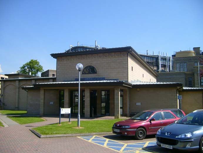
   • Wolfson Medical School building

        – Yudowitz room (WMY) - 1 of the parallel sessions.
        – Gannochy room (WMG) - 1 of the parallel sessions.
        – Atrium (WMA) is the foyer / entrance hall - lunches, tea / coffee breaks,
          poster sessions, and whisky tasting.

   • Western Infirmary Lecture Theatre (WILT) - plenary sessions and 1 of
     the parallel sessions.

                       Wolfson Medical School building

                 Western Infirmary Lecture Theatre building
5

Conference dinner
The conference dinner will be held in Òran Mór (https://oran-mor.co.uk), which is
a converted church and only 5 minutes walk away from the conference venue.

Òran Mór
Top of Byres Road,
Glasgow,
G12 8QX.

A map of the west end of Glasgow with the 3 locations is shown below. The easiest
way to get to the city centre is via the subway (underground train), and the nearest
stop is Hillhead marked on the map below with a ‘U’. It is a 15 minute trip to the
city centre (either Buchanan Street or St Enoch stations).

                                                                      Conference
                                                                      Dinner

  Wolfson Medical
  School building

  Western Infirmary
  Lecture Theatre
  building
6

General information
Registration
Registration will take place in the Atrium (entrance hall) of the Wolfson Medical
School building. The main registration sessions will be

   • Tuesday 27th August 8:15 - 9:00 and 12:50 - 13:50.

   • Wednesday 28th August 8:15 - 9:00.

However, registration will be possible throughout the duration of the conference.

Name badges
Please ensure you wear your name badges you receive at registration for security
and identification purposes throughout the entire duration of the conference.

Presentation instructions
Talks are 20 minutes long with an additional 5 minutes for questions. Please give
your talk in PDF format to the conference team before your session. This can be
done by either emailing your talk to stats-geomed@glasgow.ac.uk before the confer-
ence begins, or by bringing your talk to the registration desk on a pen drive where
we will upload it onto a laptop for you. Please name the PDF file of your talk with
your name in the format firstname surname.pdf.

Poster instructions
Poster boards will be available in the atrium of the Wolfson Medical School building,
and the poster sessions will be in the afternoon coffee breaks every day of the con-
ference. Note, you will only display your poster at one of the three poster sessions,
due to the number of posters being displayed. A list of which posters are in which
session can be found at the end of this programme. Please make sure your posters
are displayed by the lunch break on the day of your poster session, and removed by
the end of the day.

WI-FI
Free WI-FI will be available throughout the university conference venue. All dele-
gates will be emailed their unique username and password for the GUvisitor net-
work once they have registered. If you forget these details just ask one of our local
organisers at the registration desk. Alternatively, eduroam is available throughout
the university. See https://www.eduroam.org for details.

Meals and tea / coffee breaks
All lunches and tea / coffee breaks will be in the Atrium of the Wolfson Medical
School building. If you have any dietary requirements or allergies then please men-
tion this when you register for the conference.

Prizes
There will be a prizes for the best poster and the best student presentation, which
will be voted on democratically. In your registration pack you will find a voting slip
to fill in for each category. Once you have completed your voting slips please post
them in the box at the registration desk in the atrium of the Wolfson Medical School
building. In the interests of fairness, please do not vote for somebody in your own
institution.

7

Journal special issues
There will be the following special issues of journal publications that delegates of
GEOMED 2019 can submit to.

   • Statistical Methods in Medical Research - General GEOMED 2019 con-
     ference theme, contact Andrew Lawson and Duncan Lee.

   • Spatial and Spatio-temporal Epidemiology - Themed special issue on
     "Infectious disease and disease surveillance", contact Andrew Lawson and
     Rob Deardon.

Social programme
The social programme has two main components:

   • Whisky tasting - Join us for a traditional taste of Scotland, with a selection
     of fine Whisky’s to try. The whisky tasting will be in the Atrium of the Wolf-
     son Medical School building after the final invited sessions on Tuesday 27th
     August at 18:00. There will be a group photograph at 18:30.

   • Conference dinner - The conference dinner will be held at Òran Mór on
     Wednesday 28th August at 19:00, and the location is shown on the map on the
     previous page. The conference dinner will be followed by a Ceilidh, traditional
     Scottish dancing.
8

Pre-conference workshops
There are two pre-conference workshops on the morning of Tuesday 27th August
2019, which will run from 9:00 to 12:50 with a coffee break in the middle. Each
participant can only attend one workshop.

Workshop 1 - R and GIS, or R as GIS: handling and analysing spatial data

                                     Professor Roger Bivand
                                     Department of Economics,
                                     Norwegian School of Economics.

    Workshop goal - Provide enough understanding of how spatial (and maybe
spatio-temporal) data is (and will be) represented in R.
    First part - The representation of spatial and spatio-temporal data is impor-
tant to its handling and preparation for analysis. While the sp package has pro-
vided legacy representations still used by many, the sf package introduces more
modern spatial vector representations, and the stars package is moving towards a
similar modernisation of raster array representations. As yet no replacement for
the spacetime package has been proposed, although stars does reach out towards
spatio-temporal data. The first session will also describe ongoing changes in exter-
nal sofware used for representing spatial reference systems.
    Second part - GIS and R: bridges or R as GIS? The second session will present
general principles of GIS in R - R as GIS is becoming more feasible as new con-
tributed packages appear, and/or R bridges to GIS to permit GIS operations to be
done in GIS but statistical operations in R. The seesion will conclude by presenting
ongoing improvements in thematic maps in the tmap and cartography packages,
and interactive mapping in mapview.
9

Workshop 2 - Spatial and Spatio-temporal Bayesian Models with R-INLA

                                      Professor Marta Blangiardo
                                      School of Public Health,
                                      Imperial College London,

                                      Dr Michela Cameletti
                                      Department of Management, Economics and
                                      Quantitative Methods,
                                      University of Bergamo.

    Workshop goal - Provide an introduction to the Integrated Nested Laplace Ap-
proximation approach (INLA) for the analysis of spatial and spatio-temporal data
at the small area level.
    First part - We will go through the basic of INLA for Bayesian inference and
will then see how to model hierarchical structures, in particular focusing on spa-
tially structured random effects through conditional autoregressive specifications;
we will then extend the approach to include temporal dependency and touch briefly
on spatio-temporal interactions.
    Second part - After the coffee break participants will have the opportunity
of running a tutorial on their computers, implementing some of the models seen in
the first part of the workshop. It is recommended that people attending are familiar
with R (https://www.r-project.org/) and with the basic of the Bayesian approach. It
would be beneficial if attendees could bring their laptop with the latest version of R
and INLA installed.
10
Plenary lectures
There are 3 plenary lectures during the conference, which specialise in the fields of
epidemiology, geography and statistics. Our three speakers are:
Professor Ana Diez Roux
Dornsife School of Public Health
Drexel University
Places and health: history, concepts, and emerging directions
This plenary will provide an overview of epidemiologic work on places and health
over the past 25 years, identifying key conceptualizations, summarizing main method-
ologic approaches and their limitations, and identifying promising areas for future
exploration. It will reflect on what we have learned, what questions remain unan-
swered, and what emerging areas present new opportunities for the field. .
Professor Robert Haining
Department of Geography,
University of Cambridge
Spatial precision, statistical precision – having the best of both worlds
Developments in the collection, storage, retrieval and display of social, economic,
health and environmental data enable us to observe and study our world in ever
finer geographical detail. With increasing temporal frequency we are also better
able to observe and measure changes taking place over short time spans. But to
reap the benefits of spatial and spatial-temporal data precision we need to be able to
obtain reliable estimates of attribute properties for these small spatial and spatial-
temporal units. Unreliable estimation of variability associated with small area es-
timates undermines the benefits that can be derived from such data. The question
is then: how can we have the best of both worlds – spatial and spatial-temporal
precision and statistical precision?
This presentation will overview four main challenges in reaching this goal through
data modelling: dependency, heterogeneity, data sparsity and uncertainty. We then
discuss two modelling approaches - hierarchical modelling and spatial econometric
modelling – and also consider the benefits of adopting a Bayesian (rather than fre-
quentist) approach to inference. We conclude by looking briefly at some examples
of both types of data modelling that illustrate some of the opportunities that arise
in the areas of ecological modelling, infectious disease modelling and space-time
disease forecasting.11
Professor Peter Diggle
Centre for Health Informatics, Computing, and
Statistics
Lancaster University
Design and Analysis of Elimination Surveys for Neglected Tropical Dis-
eases
Neglected tropical diseases are “a diverse group of communicable diseases that
prevail in tropical and subtropical conditions in 149 countries. . . Populations living
in poverty, without adequate sanitation and in close contact with infectious vectors
and domestic animals and livestock are those worst affected” (WHO web-site). In-
ternational efforts to control these diseases have led to considerable reductions in
prevalence to the point where, for many NTDs, their elimination as a public health
problem has become a realistic proposition.
A strategy to confirm (or not) that elimination has been achieved requires con-
sideration of (at least) the following issues.
1. What is the definition of elimination? Typically, this is that average prevalence
over a defined geographical region, A, does not exceed a specified threshold, but
other definitions are possible. For example, a low average prevalence could conceal
isolated hot-spots of residual infection.
2. What is the appropriate choise for A? Typically, this will be an administrative
region corresponding to a geographical unit on which a policy decision will be made
(for example, cessation of mass treatment with prophylactic medication).
3. What level of uncertainty is acceptable to those responsible for making policy
decisions? In low resource settings, where population-wide testing is impractical,
some level of uncertainty is inevitable.
4. What data should be collected, and how should they be analysed?
In this talk, I will argue that the correct inferential framework for this problem
is neither estimation nor testing, but rather prediction. This point of view leads to
the following working definition of elimination, with obvious variations. Let n( x) be
the population density at location x and p( x) the probability that an individual at x
has the disease in question. The population-weighted average prevalence over A is
Z
AP = p( x) dn( x),
A
and elimination is achieved if, given user-specified values for two positive constants,
c and q,
Prob( AP < c) > q.
It follows that the goal of the study-design should be to deliver as tight as possible
a predictive distribution for AP when its true value is close to c, subject to context-
specific practical constraints. In my experience, this requires a statistical model for
spatially referenced prevalence data that takes account of both measured covariate
effects and unexplained stochastic spatial variation in p( x).
Acknowledgment
Work-in-progress funded by the Gates Foundation through a grant to the Ne-
glected Tropical Diseases Modelling Consortium led by Prof Deirdre Hollingsworth
(University of Oxford).12
Programme
Below is the scientific programme for the conference, which uses the following
acroynms.
WMA - Wolfson Medical School building Atrium - ground floor.
WMG - Wolfson Medical School building Gannochy room - ground floor.
WMY - Wolfson Medical School building Yudowitz room - ground floor.
WILT - Western Infirmary Lecture Theatre building - ground floor.
Student presenters
So you know who is eligible to win the best student prize, all MSc / PhD students
presenting have a S after their surname.
Key
C
- Contributed talk.
P
- Plenary talk.
S
- Student talk.
I
- Invited talk.
W
- Invited workshop.
Day 1 - 27th August 2019
8:30 - 9:00 - Registration (WMA).
9:00 -10:40 - Workshops
R and GIS, or R as GIS: handling and analysing spatial data (WMG)
Roger BivandW , Norwegian School of Economics
Spatial and Spatio-temporal Bayesian Models with R-INLA (WMY)
Marta BlangiardoW , Imperial College London
Michela CamelettiW , University of Bergamo
10:40 - 11:10 - Tea / Coffee break (WMA).
11:10 -12:50 - Workshops
R and GIS, or R as GIS: handling and analysing spatial data (WMG)
Roger BivandW , Norwegian School of Economics13
Spatial and Spatio-temporal Bayesian Models with R-INLA (WMY)
Marta BlangiardoW , Imperial College London
Michela CamelettiW , University of Bergamo
12:50 - 13:40 - Lunch and registration (WMA).
13:40 - 13:50 - Welcome to GEOMED 2019 (WILT)
Duncan Lee, University of Glasgow
13:50 - 14:35 - Plenary lecture 1 (WILT)
Chair - Marian Scott, University of Glasgow
Design and Analysis of Elimination Surveys for Neglected Tropical
Diseases
Peter DiggleP , Lancaster University
14:40 - 15:30 - Contributed sessions
Air pollution and health (WILT)
Chair - Marcos Prates, Universidade Federal de Minas Gerais
14:40 - 15:05 Estimation of health co-benefits gained through the re-
duction of air pollution through the implementation of global
climate mitigation commitments
Gavin ShaddickC , University of Exeter
15:05 - 15:30 A multivariate hierarchical model for the use of pollut-
ing fuels for cooking
Theo EconomouC , University of Exeter
Spatial inequalities 1 (WMG)
Chair - Margherita Silan, University of Padua
14:40 - 15:05 Spatial variations and differences in incidence rates from
1986 to 2015 in atrial fibrillation and atrial flutter in Denmark
Kristine BihrmannC , University of Southern Denmark
15:05 - 15:30 Does survival after acute myocardial infarction depend
on where you live?
Annette ErsbøllC , University of Southern Denmark14
Childhood ill health 1 (WMY)
Chair - Michael Kramer, Emory University
14:40 - 15:05 A geospatial analysis of childhood immunisation and as-
sociated factors: a cross-sectional study in New Zealand
Lukas MarekC , University of Canterbury
15:05 - 15:30 Mental health and cognitive development responses in
London’s children shift with natural habitat type exposure
Mikaël MaesSC , University College London & Imperial College London
15:30 - 16:10 - Tea / Coffee break and posters (WMA).
16:10 - 17:50 - Invited sessions
Spatio-temporal infectious disease modeling (WILT)
Chair - Chawarat Rotejanaprasert, Mahidol University
16:10 - 16:35 GEM: A domain-specific modelling language for rapid
development of inference and simulation for epidemic models
Chris Jewell I , Lancaster University
16:35 - 17:00 Forecasting based on surveillance data
Sebastian Meyer I , University of Erlangen-Nuremberg
17:00 - 17:25 Identifying spatial dynamics of infectious disease spread
via machine learning classifiers
Rob Deardon I , University of Calgary
17:25 - 17:50 Real Time Decision Making for Infectious Disease Out-
breaks
Mike Tildesley I , Warwick University
Small area deprivation and health (WMG)
Chair - Alastair Leyland, University of Glasgow
16:10 - 16:35 Inequalities in mortality in Scotland: what happens when
we change the level of geography used to assess area depriva-
tion?
Denise Brown I , University of Glasgow
16:35 - 17:00 Using the NZ Index of Multiple Deprivation (IMD) to in-
form research, policy and populations
Daniel Exeter I , University of Auckland
17:00 - 17:25 Creating a small area deprivation index for Brazil to as-
sess inequalities in mortality
Elzo Júnior I , Center for Data Integration and Health Knowledge15
17:25 - 17:50 Exploring patterns of association between Experian’s Mo-
saic classification and all-cause mortality in England: implica-
tions for further research
Welcome Wami I , University of Glasgow
Spatial and temporal epidemiology across the lifecourse I (WMY)
Chair - Jamie Pearce, University of Edinburgh
16:10 - 16:35 Historical Air Pollution and Brain Health: Life Course
Epidemiology Insights from the Lothian Birth Cohort 1936
Tom Russ I , University of Edinburgh
16:35 - 17:00 Green space and mental wellbeing: a study of residential
relocation among mid-older aged adults
Alison Carver I , Australian Catholic University
17:00 - 17:25 Is the association between the density of fast food out-
lets and obesity confounded by socioeconomic context? A longi-
tudinal analysis of children in the Millennium Cohort Study
Mark Green I , University of Liverpool
17:25 - 17:50 Recent rises buck long-term reductions in subnational
Infant Mortality Rates: UK 1981 to 2017
Paul Norman I , University of Leeds
18:00 - 19:00 - Whisky tasting (WMA) and group photo.16
Day 2 - 28th August 2019
8:30 - 9:00 - Registration (WMA).
9:00 - 10:40 - Invited sessions
Learning from aggregated spatial epidemiological and survey data (WILT)
Chair - Nema Dean, University of Glasgow.
9:00 - 9:25 Ecological inference for infectious disease data, with ap-
plication to vaccination strategies
Leigh Fisher I , Fred Hutchinson Cancer Research center
9:25 - 9:50 Bayesian spatial smoothing methods for analysis of spatial
survey data
Christel Faes I , Hasselt University
9:50 - 10:15 Accounting for survey design in Bayesian disaggregation
of survey-based areal estimates of proportions
Marco H. BenedettiSI , University of Michigan
10:15 -10:40 Pseudo-continuous spatial inference from aggregated dis-
ease count data
Duncan Lee I , University of Glasgow
Public health spatial epidemiology (WMG)]
Chair - Chris Robertson, Strathclyde University
9:00 - 9:25 An epidemiological risk assessment for arsenic in private
water supplies based on geology
Helen Crabbe I , Public Health England
9:25 - 9:50 Investigating the variation of antibiotic prescribing rates
between NHS Scotland health-boards and GP practices through
the use of maps, principal components and spatial analysis
Florence TydemanSI , Strathclyde University
9:50 - 10:15 Estimating the impact of air pollution in Scotland and po-
tential benefits of pollutant concentration reductions
Colin Ramsay I , Health Protection Scotland
10:15 -10:40 Public Health Applications of a Bayesian space–time model
for clustering areal units based on their disease trends
Chris Robertson I , Strathclyde University
Spatial and temporal epidemiology across the lifecourse II (WMY)
Chair - Jamie Pearce, University of Edinburgh17
9:00 - 9:25 Life course neighbourhood deprivation effects on body mass
index: quantifying the importance of selective migration.
Paul Norman I , University Leeds (on behalf of Emily Murray)
9:25 - 9:50 Illness and the lifecourse: does the relationship vary by
cohort?
Lucy PriorSI ,University of Bristol
9:50 - 10:15 A longitudinal analysis of police-recorded crime and men-
tal health in Scotland
Gergő BaranyiSI , University of Edinburgh
10:15 - 10:40 Exposure to air pollution in early life and cognitive abil-
ity: a prospective 1936 birth cohort
Chris Dibben I , University of Edinburgh
10:40 - 11:10 - Tea / Coffee break (WMA).
11:10 - 12:50 - Invited sessions
Spatial statistics and the new digital data collection technologies (WILT)
Chair - Renato Assunção, Universidade Federal de Minas gerais
11:10 - 11:35 Spatio-temporal water-quality monitoring in the infor-
mation age
Erin Peterson I , Queensland University of Technology
11:35 - 12:00 Alleviating spatial confounding for areal data problems
by displacing the geographical centroids
Marcos Prates I , Universidade Federal de Minas Gerais
12:00 - 12:25 Projection-based Methods for Fitting Spatial General-
ized Linear Mixed Models
Murali Haran I , Penn State University
12:25 -12:50 Univariate and Multivariate Directed Acyclic Graphical
Models for Disease Mapping
Sudipto Banerjee I , University of California Los Angeles
Geostatistical methods for global health (WMG)
Chair - Annibale Biggeri, University of Florence
11:10 - 11:35 A geostatistical framework for combining spatially ref-
erenced prevalence data from multiple diagnostics
Benjamin AmoahSI , Lancaster University
11:35 - 12:00 Reconciling health facility case counts of malarial fevers
with parasite prevalence survey data via Bayesian hierarchical
modelling
Ewan Cameron I , Oxford University18
12:00 - 12:25 Spatio-temporal Geostatistical Modelling to jointly Pre-
dict Exposure and Disease
Dolores Catelan I , University of Florence
12:25 -12:50 Spatiotemporal geostatistical preferential sampling mod-
elling for exposure assessment in epidemiological cohort study
on air pollution and maternal health
Annibale Biggeri I , University of Florence
GIS and Public Health (WMY)
Chair - Bob Haining, University of Cambridge
11:10 - 11:35 Measuring the Access to Healthy Assets and Hazards for
Great Britain
Konstantinos Daras I , University of Liverpool
11:35 - 12:00 Developing a locally adaptive spatial multi-level logistic
model to analyse ecological effects on health
Guanpeng (Gavin) Dong I , University of Liverpool
12:00 - 12:25 Exploring spatial patterns of greenspace use derived from
GPS data from a mobile phone app
Paul Brindley I , University of Sheffield
12:25 -12:50 Alcohol outlet density and alcohol-related hospital ad-
missions in England
Ravi Maheswaran I , University of Sheffield
12:50 - 13:50 - Lunch (WMA).
The editorial board meeting for Spatial and Spatio-Temporal Epidemiology
will take place between 13:00 - 13:45 in the Hugh Fraser room in the
Wolfson Medical School building.
13:50 - 14:35 - Plenary lecture 2 (WILT)
Chair - Andrew Lawson, Medical University of South Carolina
Places and health: history, concepts, and emerging directions
Ana Diez RouxP , Drexel University
14:40 - 15:30 - Contributed sessions
Spatio-temporal clustering (WILT)
Chair - Rachel Lowe, London School of Hygiene & Tropical Medicine
14:40 - 15:05 Spatial scan statistics can be dangerous
Toshiro TangoC , Center for Medical Statistics, Japan & Teikyo
University19
15:05 - 15:30 Detecting Spatial Clusters of Disease Infection Risk Us-
ing Sparsely Sampled Social Media Mobility Patterns
Renato AssunçãoC , Universidade Federal de Minas Gerais
Spatio-temporal variation in mental health (WMG)
Chair - Alison Carver, Australian Catholic University
14:40 - 15:05 Do spatiotemporal social fragmentation and deprivation
affect suicide risk? A Dutch register-based case-control study
Paulien HagedoornC , Utrecht University
15:05 - 15:30 Development of the Australian Neighbourhood Social Frag-
mentation Index and its association with spatial variation in de-
pression across communities
Nasser BagheriC , The Australian National University
Childhood ill health 2 (WMY)
Chair - Annette Annette ErsbØll, University of Southern Denmark
14:40 - 15:05 Spatial distribution of wasting, stunting, and underweight
among children aged 5 and under in Kenya: A shared compo-
nents modelling approach
Thomas AchiaC , University of the Witwatersrand
15:05 - 15:30 Estimating under-five mortality and the coverage of health
service provision in Kenya: A subnational spatio-temporal anal-
ysis, 1965-2015
Peter M MachariaSC , KEMRI Wellcome Trust Research programme, Nairobi
15:30 - 16:10 - Tea / Coffee break and posters (WMA).
16:10 - 17:50 - Invited sessions
Spatial modelling of health in Scotland (WILT)
Chair - Nema Dean, University of Glasgow
16:10 - 16:35 Spatial clustering of risks in disease mapping
Craig Anderson I , University of Glasgow
16:35 - 17:00 A multivariate space-time model for trend examination
and prediction of acute respiratory infection
Gary Napier I , University of Glasgow
17:00 - 17:25 Grid square level inference in Bayesian disease mapping
Kamol SanitthamSI , University of Glasgow20
17:25 - 17:50 Estimating the changing nature of Scotland’s health in-
equalities using a multivariate spatio-temporal model
Eilidh Jack I , University of Glasgow
Modelling and inference in environmental epidemiology (WMG)
Chair - Theresa Smith, University of Bath
16:10 - 16:35 Using propensity score to adjust for residual confound-
ing in area-referenced environmental health studies
Monica Pirani I , Imperial College London
16:35 - 17:00 Daily mortality and air quality: using multivariate time
series with seasonally-varying covariances
Guowen Huang I , University of Toronto
17:00 - 17:25 Data integration for high-resolution, continental-scale
estimation of air pollution concentrations
Matt ThomasSI , University of Bath
17:25 - 17:50 Mapping ‘Rattiness’ to understand leptospirosis trans-
mission in Salvador, Brazil: A geostatistical modelling approach
to combining three rat metrics.
Max EyreSI , Lancaster University
Spatial and temporal epidemiology across the lifecourse III (WMY)
Chair - Jamie Pearce, University of Edinburgh
16:10 - 16:35 Detecting time-series horizontal and vertical building
density at neighbourhood scales with open access remote sens-
ing data
Tzu-Hsin Karen ChenSI , Aarhus University
16:35 - 17:00 The great recession, austerity and mental health in Scot-
land: moderating roles of green space and social cohesion
Mark Cherrie I , University of Edinburgh
17:00 - 17:25 The effect of neighbourhood crime and deprivation on
pregnancy outcomes. A quasi-experimental study using routine
administrative records
Tom Clemens I , University of Edinburgh
17:25 - 17:50 To what extent do Green and Blue Spaces improve our
mental health and wellbeing?
Amy Mizen I , Swansea University
19:00 - late - Conference dinner and Ceilidh21
Day 3 - 29th August 2019
9:00 - 10:40 - Invited sessions
On disease mapping: modelling and fitting techniques (WILT)
Chair - Maria Dolores Ugarte, Universidad Publica de Navarra
9:00 - 9:25 Disease mapping using complex survey data
Geir-Arne Fuglstad I , Norwegian University of Science and Technology
9:25 - 9:50 Disease risk estimation in small areas exploiting the un-
derlying clustering structure of the data
Guzman Santafe I , Universidad Publica de Navarra
9:50 - 10:15 Trends in Tract-Level Obesity Rates in Philadelphia by
Race/Ethnicity, Space, and Time
Harrison Quick I , Drexel University
10:15 -10:40 Spatial Smoothing in Stan: insights from implementa-
tions of the ICAR prior and the BYM2 model
Mitzi Morris I , Columbia University
Mapping zoonotic vectors for public health (WMG)
Chair - George Gunn, Scotland’s Rural College
9:00 - 9:25 What information do we need to model the spatial distri-
bution of zoonotic vectors
William Wint I , Environmental Research Group Oxford
9:25 - 9:50 Field Sampling strategy for spatial distribution modelling
Cedric Marsboom I , AVIA-GIS
9:50 - 10:15 Modelling spatial distribution of ticks in Scotland
Rita RibeiroSI , Scotland’s Rural College
10:15 -10:40 Predicting tsetse abundance: remote sensing and the im-
pact of insecticide treated cattle in Tanzania
Rachel LeaSI , Liverpool School of Tropical Medicine
Application of geospatial technologies in health geography and spatial
epidemiology (WMY)
Chair - Sue C. Grady, Michigan State University
9:00 - 9:25 Safety from a bird’s eye-view: Remote sensing of high-resolution
data in automobile-pedestrian accidents
Raechel Portelli I , Michigan State University
9:25 - 9:50 Maternal and Infant Health in Central-Michigan: Environ-
mental Investigation of Industrial Emitted Neurotoxins on Ad-
verse Birth Outcomes
Amanda KreuzeSI , Michigan State University22
9:50 - 10:15 Environmental Health: A LiDAR Assessment of Urban Neigh-
bourhoods
Sue C. Grady I , Michigan State University
10:15 -10:40 From spatial data to health action: The March of Dimes
Geo-Equity App
Michael Kramer I , Emory University
10:40 - 11:10 - Tea / Coffee break (WMA).
11:10 - 12:50 - Invited / Contributed sessions
Statistical advances in environmental epidemiology (Invited, WILT)
Chair - Marta Blangiardo, Imperial College London
11:10 - 11:35 Mitigating the effects of preferentially selected pollution
monitoring sites for inference on population health
Joe WatsonSI , University of British Columbia
11:35 - 12:00 Mapping vaccination coverage rates at high resolution
to explore the effects of delivery mechanisms
Chigozie Edson Utazi I , University of Southampton
12:00 - 12:25 Mapping Trypansoma cruzi infection prevalence
Andre Python I , University of Oxford
12:25 -12:50 Spatio-temporal two-stage models for environmental re-
search
Antonio Gasparrini I , London School of Hygiene and Tropical Medicine
Infectious disease 1 (WMG)
Chair - Kathryn Hacker, University of Pennsylvania
11:10 - 11:35 Spatio-temporal modeling of neighborhood level risks
for dengue, chikungunya, and Zika in Cali, Colombia
Michael R. DesjardinsSC , University of North Carolina at Charlotte
11:35 - 12:00 A coupled model framework to detect nonlinear and de-
layed impacts of climate on dengue risk
Rachel LoweC , London School of Hygiene & Tropical Medicine
12:00 - 12:25 Dengue diffusion in Sao Paulo State, Brazil, 1987-2012
Rafael CatãoC , University of Espirito Santo
12:25 -12:50 Mapping environmental receptivity to dengue and chikun-
gunya
Claudia Torres CodeçoC , Fundação Oswaldo Cruz23
Spatial epidemiology (WMY)
Chair - Russell Kirby, University of South Florida
11:10 - 11:35 Association between low-level arsenic concentration in
drinking water and incidence rate of stroke
Annette ErsbøllC , University of Southern Denmark
11:35 - 12:00 Distance sampling for epidemiology: estimating under-
reporting of cases from clinic data
Luca NelliC , University of Glasgow
12:00 - 12:25 When theory and practice collide: A study of ground am-
bulance bases in Southern Norway
Jo RøislienC , University of Stavanger
12:25 -12:50 A bayesian factor model for spatial panel data
Maura MezzettiC , Università Tor Vergata
12:50 - 13:40 - Lunch (WMA).
13:40 - 15:20 - Invited sessions
Spatio-temporal disease surveillance (WILT)
Chair - Andrew Lawson, Medical University of South Carolina
13:40 - 14:05 A spatio-temporal hierarchical Markov switching model
for the early detection of influenza outbreaks
David Conesa I , University of Valencia
14:05 - 14:30 Geographically-dependent individual-level models (GD-
ILMs) for infectious diseases transmission
MD MahsinSI , University of Calgary
14:30 - 14:55 Distributed lagged modelling for spatio-temporal areal
data with excessive zeros
Chawarat Rotejanaprasert I , Mahidol University
14:55 -15:20 A Hybrid Hierarchical Bayesian Model for Spatio-Temporal
Surveillance Data
Jian (Frank) Zhu I , Worcester Polytechnic Institute
Urban Health (WMG)
Chair - Maria de Fátima de Pina, University of Porto
13:40 - 14:05 Urbanization and health in Latin America: the SALUR-
BAL Study
Ana Diez Roux I , Drexel University24
14:05 - 14:30 Observatory for Urban Health in Belo Horizonte City:
eighteen years strengthening ties and opportunities in public
health research and education contextualized in urban environ-
ment
Waleska Caiaffa I , Federal University of Minas Gerais
14:30 - 14:55 Mental wellbeing of older urban residents: the MINDMAP
project
Frank J. van Lenthe I , Utrecht University
14:55 -15:20 Household survey on influenza-like illness and health re-
lated behaviour in urban quarters of Basel, Switzerland
Nina GoldmanSI , University of Basel
Spatial mobility and simulation; new tools for understanding how envi-
ronment affects health (WMY)
Chair - Richard Mitchell, University of Glasgow
13:40 - 14:05 Relationships between individual and urban character-
istics and mobility for 122 individuals living in Antwerp, Barcelona
and London
Jonathan Olsen I , University of Glasgow
14:05 - 14:30 The relationship between children’s objectively measured
time spent outdoors, contact with nature, and emotional and be-
havioural resilience
Paul McCrorie I , University of Glasgow
14:30 - 14:55 The influence of space and social mix on patterns of ur-
ban green space usage. An Agent-based model
Stefano Picascia I , University of Glasgow
14:55 -15:20 Using an agent-based model to investigate the impact of
neighbourhood settings on children’s physical activities
Jonatan Almagor I , University of Glasgow
15:20 - 16:00 - Tea / Coffee break and posters (WMA).
16:00 - 16:50 - Contributed sessions
Statistical methods for infectious disease (WILT)
Chair - Marco H. Benedetti, University of Michigan
16:00 - 16:25 Outfoxing rabies: a case study for fitting non-separable
space-time log-Gaussian Cox models using R-INLA
Laurie BakerC , University of Glasgow
16:25 - 16:50 Computational approaches to Bayesian Spatio-Temporal
Surveillance of small area health data
Andrew LawsonC , Medical University of South Carolina25
Infectious disease 2 (WMG)
Chair - Chawarat Rotejanaprasert, Mahidol University
16:00 - 16:25 Estimating the spread of tick-borne encephalitis virus in
ticks and hosts
Melanie WalterC , University of Veterinary Medicine Vienna
16:25 - 16:50 Mapping the burden of dengue in Indonesia to guide fu-
ture Wolbachia programmes
Oliver J BradyC , London School of Hygiene & Tropical Medicine,
London
Spatial inequalities 2 (WMG)
Chair - Rachel Carroll, University of North Carolina at Wilmington
16:00 - 16:25 Antibiotic Prescribing Patterns in General Medical Prac-
tices in England: Does Area matter?
Anna MolterC , University of Manchester
16:25 - 16:50 The spatial physiognomy of homicides: a comparison be-
fore and after slum upgrading interventions in Belo Horizonte,
Brazil
Waleska CaiaffaC , Federal University of Minas GeraisC
16:55 - 17:40 - Plenary lecture 3 (WILT)
Chair - Ravi Maheswaran, University of Sheffield
Spatial precision, statistical precision – having the best of both worlds
Robert HainingP , University of Cambridge
17:40 - 18:00 - Awards and introducing GEOMED 2021 (WILT)
Duncan Lee, University of Glasgow and
Veronica Berrocal, University of Michigan26
List of posters
Below is a list of the posters being exhibited on each day of the conference.
Session 1 - Tuesday 27th August 15:30pm - 16:10pm
1. Identifying Environmental Risk Factors and Mapping Scrub Typhus
Disease Transmission risk in Nepal using MaxEnt, Random Forest
and BRT Model
Bipin Acharya, University, Guangzhou
2. Simulating spatial distribution of Dengue in Rio de Janeiro using a
SIR model coupled to environmental forcing
Leon Diniz Alves, Fundação Getúlio Vargas
3. Risk maps, spatial coverage and incentives: An innovative approach
for Chagas disease surveillance
Claudia Arévalo-Nieto, Universidad Peruana Cayetano Heredia
4. Skin cancer geography in Germany
Jobst Augustin, University Medical Center Hamburg-Eppendorf
5. Random Tree Boosting for Automated Regionalization of Disease Pat-
terns
Orhun Aydin, ESRI
6. Multivariate Space-Time Disease Mapping via Nonparametric Explo-
ration of Disease Risk
Daniel Baer, Medical University of South Carolina
7. Health and mobility: exploring access to primary health care through
mobile medical clinics in rural Honduras
Liam Barrett, NHS and Lancaster University
8. Spatio-temporal analysis of Chikungunya cases in Rio de Janeiro State
between 2016 and 2018
Leonardo Bastos, Fundação Oswaldo Cruz
9. Multivariate modelling of geographical differences in three cardio-
vascular diseases
Kristine Bihrmann, University of Southern Denmark
10. Population mapping and estimation for more targeted vaccination
campaigns in the Democratic Republic of Congo
Gianluca Boo, University of Southampton
11. Predicting the TBE and Lyme borreliosis vector Ixodes ricinus in
space and time
Katharina Brugge, University of Veterinary Medicine Vienna
12. MU-MAP (Managing Uncertainties in Modelling Air Pollution)
David Cameron, Centre for Ecology and Hydrology
13. Spatial inequalities of food retail in the municipality of Rio De Janeiro
Leticia Cardoso, Fundação Oswaldo Cruz27
14. An analysis of event impact across multiple cancers: Accessing spatio-
temporal variation in cancer-specific mortality for Louisiana SEER
data
Rachel Carroll, University of North Carolina at Wilmington
15. Detecting spatio-temporal hotspots of scarlet fever in Taiwan with
spatio-temporal Gi* statistic
Ta-Chien Chan, Academia Sinica
16. Geostatistical analysis of Malawi’s changing malaria transmission from
2010 to 2017
Michael Give Chipeta, University of Oxford
17. Bayesian Spatio-temporal SIR model for Epidemic data in Korea
Jungsoon Choi, Hanyang University
18. Mobile population and risk of malaria in the Amazon Basin
Claudia Torres Codeço, Fundação Oswaldo Cruz
19. Evaluating dengue forecasting model to predict Zika and Chikun-
gunya in Brazil
Flávio Codeço Coelho, Fundação Getulio Vargas
20. Greenness measures expressed as NDVI; does resolution Matter?
Neil Coffee, University of Canberra
21. Assessing Spatial Variation in Cognitive Health in Relation to Neigh-
borhood Environment
Anne E Corrigan, Johns Hopkins Bloomberg
22. Spatial sampling in the absence of a national census
Édith Darin, University of Southampton
23. Environmental change and socio-political drivers of malaria risk in
El Oro province, Ecuador
Isabel Fletcher, London School of Hygiene & Tropical Medicine
24. Bayesian spatial modelling and prediction of terrestrial background
radiation in Switzerland
Christophe Folly, University of Bern
25. Transmission of multidrug resistant tuberculosis in Shanghai: a population-
based study
Erjia Ge, University of Toronto28
Session 2 - Wednesday 28th August 15:30pm - 16:10pm
26. Zika related microcephaly epidemic in Brazil: why such different at-
tack rates?
Leonardo Bastos, Fundação Oswaldo Cruz
27. Methodological considerations in constructing a space-time model of
asthma emergency department risk: a case study in South Carolina
1999-2015
Matthew Bozigar, Medical University of South Carolina
28. Web data mining: validity of a new tool for food retail data – First
results from Rio de Janeiro, Brazil
Leticia Cardoso, Fundação Oswaldo Cruz
29. New guidance for investigating non-infectious disease clusters from
potential environmental causes
Helen Crabbe, Public Health England
30. Floods and Leptospirosis in Brazilian Municipalities – 2003 to 2013
Renata Gracie, Oswaldo Cruz Foundation-Fiocruz
31. Surveillance of the emergence of anthelmintic resistance in human
population with soil-transmitted helminths in southern Mozambique
Berta Grau-Pujol, Barcelona Institute for Global Health
32. Mapping the Effects of Bed Bug Policy in New York City
Kathryn Hacker, University of Pennsylvania
33. Comparing spatio-temporal methods of non-communicable disease
surveillance
Mico Hamlyn, Imperial College London
34. E-cigarette and Menthol Use Disparities between San Francisco Bay
Area Young Adults Living in Cities with and without Flavored To-
bacco Sales Restrictions
Louisa M. Holmes, Binghamton University
35. Malaria resurgence and illegal gold mining activities in the state of
Bolivar, Venezuela
Christopher Jarvis, London School of Hygiene & Tropical Medicine
36. Subnational disparities on immunization coverage and spatial access
to immunizing facilities in Kenya
Noel Kanini Joseph, Kenya Medical Research Institute
37. District-level estimates of Hypertension in Burkina Faso: Application
of Small Area Estimation Techniques
Cisse Kadari, Université libre de Bruxelles
38. Bayesian spatio-temporal boundary detection methods for disease
mapping
Dayun Kang, Hanyang University29
39. Bayesian Inference for Crime Incidence in the USA
Nadeen Khaleel, University of Bath
40. Spatiotemporal Reconstruction of Forest Inventory Map Using Re-
mote Sensing Observations
Md Kamrul Hasan Khan, University of Arkansas
41. Investigation of the environmental connection between cattle and
human EHEC cases
Hyeyoung Kim, National Veterinary Institute
42. Regional health care and demographic change in Germany
Anne Kis, University Medical Center Hamburg-Eppendorf
43. Socio-spatial epidemiology of maternal mortality in the U.S.
Michael R. Kramer, Emory University
44. Temporal Associations of Determinants on Cardiovascular and Res-
piratory Emergency Department Visits
Anne Krefis, University Medical Center Hamburg-Eppendorf
45. Spatial tracking of the current Ebola outbreak in Congo
Ashok Krishnamurthy, Mount Royal University
46. Adjusted, non-Euclidean cluster detection of Vibrio parahaemolyti-
cus in the Chesapeake Bay
Anton Kvit, Johns Hopkins Bloomberg
47. Onde é o garimpo? A mobile application to map cases of malaria on
clandestine gold mining sites in French Guiana
Yann Lambert, Centre d’Investigation Clinique Antilles-Guyane
48. Socio-economic characteristics associated with mortality among small-
areas in Cyprus
Demetris Lamnisos, European University Cyprus
49. Bayesian Spatial Analysis of Drug Mortality Rates in Virginia
Jong Hyung Lee, Virginia Commonwealth University
50. The role of climate, cities and connectivity in the spread of mosquito-
borne diseases in Brazil
Sophie Lee, London School of Hygiene and Tropical Medicine
51. Spatial models for infants HIV/AIDS incidence using an integrated
nested laplace approximation approach
Susan Nzula, Strathmore University30
Session 3 - Thursday 29th August 15:20pm - 16:00pm
52. Evaluation of spatial and spatio-temporal variation in distribution
and determinants of female genital cutting among girls aged 0-14
years in Nigeria, 2003-2017
Glory Atilola, Northumbria University
53. The Eco-epidemiology of leptospirosis: mapping spill-over infection
in complex environments
Kathryn Hacker, University of Pennsylvania
54. Climate Variability Assessment And The Nexus On Human Health In
Gombe Metropolis, Nigeria
Yahaya Ibrahim, Gombe State University
55. Detecting Local Clusters of Childhood Malnutrition in the Island Province
of Marinduque, Philippines
Novee Lor C. Leyso, University of the Philippines Manila
56. Survivable road-trauma resulting in a pre-hospital death: a geospa-
tial examination of access to timely advanced trauma care in New
Zealand, 2009-2012
Rebbecca Lilley, University of Otago
57. Tuberculosis and its socioeconomic determinants in Rio de Janeiro:
a study applying Geographically Weighted Regression
Mônica de Avelar Figueiredo Mafra Magalhães, Oswaldo Cruz Foundation
58. MUsing nationwide linked microdata to examine the effect of tran-
sience on the long-term health conditions and health services utilisa-
tion
Lukas Marek, University of Canterbury
59. Burn the clipboard: Using a mobile app to bring site evaluation into
the digital era
Anna Mölter, University of Manchester
60. Comparison of machine learning and geostatistical models in regions
of low malaria risk using a combination of point surveys and aggre-
gated surveillance data
Anita Nandi, University of Oxford
61. Short-term spatial forecasting to aid the elimination of Visceral Leish-
maniasis in India
Emily Nightingale, London School of Hygiene & Tropical Medicine
62. Timely access to emergency services in Brazil
Ricardo Antunes Dantas de Oliveira, Oswaldo Cruz Foundation
63. Classifying areas into hot/coldspots and studying the temporal dy-
namic of these areas within each risk category: A Bayesian two stage
method applied to severe malaria in Burkina Faso
Mady Ouédraogo, Université libre de Bruxelles31
64. Measuring spatiotemporal dependence of disease using the tau and
phi statistics: a literature review, normative commentary and new
avenues
Timothy Pollington, University of Warwick
65. A novel approach for spatial segmentation problem
Nishanthi Raveendran, Macquarie University
66. Spatial distribution and risk in Maternal Mortality in Burkina Faso:
hierarchical Bayesian approach using routinely-collected health data
Toussaint Rouamba, National Center for Scientific and Technological
Research Burkina Faso and Université libre de Bruxelles
67. Utilising an ‘adaptive raster’ approach to reduce uncertainty in sub-
national c-section estimates in Tanzania, 2015
Corrine Warren Ruktanonchai, University of Southampton
68. Multiple-criteria decision analysis of healthy urban planning
Andrea Salmi , École polytechnique fédérale de Lausanne
69. Use of Spatial Analysis to Assess Seasonal Differences of Access to
Care in Rural Zambia
Timothy Shields, Johns Hopkins Bloomberg
70. Neighbourhoods, selection bias and the MARMoT approach to com-
pare unbalanced groups
Margherita Silan, University of Padua
71. District vulnerability to extreme heat temperatures in Mainland Por-
tugal
Susana Pereira da Silva, Nacional de Saúde Doutor Ricardo Jorge
72. Colorectal cancer survival in England and Wales by socio-economic
status and area deprivation
Charlotte Sturley, University of Leeds
73. Association between magnesium in drinking water and cardiovascu-
lar mortality
Charlotte Friis Theisen, University of Southern Denmark
74. Creating a 20 minute neighbourhood measure
Lukar Thornton, Deakin University
75. Using related parent-child data to examine associations between child-
hood, parental and environmental characteristics and childhood obe-
sity
Melanie Tomintz, University of Canterbury
76. Prevalence and geographical variation of dementia in New Zealand
from 2012-2015: utilising big data within the Integrated Data Infras-
tructure
Katherine Walesby, University of Edinburgh
77. Evaluating the spatio-temporal heterogeneity of dengue in Colombo
city, Sri Lanka
Nayantara Wijayanandana, London School of Hygiene & Tropical Medicine32
78. Spatial clustering of suicide death rate in Kanagawa prefecture, Japan
Kazue Yamaoka, Teikyo University
79. Patient’s willingness to bypass the nearest physician – Findings from
outpatient dermatological care in Germany
Nicole Zander, University Medical Center Hamburg-EppendorfYou can also read


