A CENTURY OF FIGHTING TRAFFIC IN LOS ANGELES - BY MARTIN WACHS, PETER SEBASTIAN CHESNEY, AND YU HONG HWANG - UCLA ...
←
→
Page content transcription
If your browser does not render page correctly, please read the page content below
A CENTURY OF
      FIGHTING TRAFFIC
         CONGESTION
       IN LOS ANGELES
                     1920-2020
BY MARTIN WACHS, PETER SEBASTIAN CHESNEY, AND YU HONG HWANG
A Century of Fighting Traffic Congestion in Los Angeles

                                     1920-2020

            By Martin Wachs, Peter Sebastian Chesney, and Yu Hong Hwang

                                     September 2020

                                         Preface

             “Understanding why traffic congestion matters is … not a matter
             of documenting real, observable conditions, but rather one of
                     revealing shared cultural understandings.”
                                     Asha Weinstein1

      The UCLA Luskin Center for History and Policy was founded in 2017 through a
generous gift from Meyer and Renee Luskin. It is focused on bringing historical
knowledge to bear on today’s policy deliberations. Meyer Luskin stated that “The best
way to choose the path to the future is to know the roads that brought us to the present.”
This study is quite literally about roads that brought us to the present.
      The Los Angeles region is considering alternative forms of pricing roads in order to
address its chronic congestion. This is a brief history of a century of effort to cope with
traffic congestion, a perennial policy challenge in this region. The authors, like the
Luskins, believe that the current public debate and ongoing technical studies should be
informed by an understanding of the past. We do not duplicate technical or factual
information about the current situation that is available elsewhere and under scrutiny
by others. We also do not delve deeply into particular historical events or past policies.
We hope this overview will be useful to lay people and policy practitioners participating
in the public dialog about dynamic road pricing that will take place over the coming
several years. Our intended audience is neither transportation engineers and planners
nor academic historians. The footnotes will hopefully lead those interested in greater
depth to sources they will find useful.
      The authors express gratitude to the Luskin Center for its support, and to its
Director, Professor David Myers, for his guidance throughout the project. Maia
Ferdman, the Luskin Center’s Program Manager, administered the project and edited
and formatted this report. Sona Babayan helped us by gathering information about
congestion pricing in other countries. Elham Shirazi offered advice about
telecommuting. We received helpful comments on an early draft from Professors Asha
Agrawal, Eric Avila, William Deverell, Genevieve Giuliano, Michael Manville, David
Myers, Peter Norton, Virginia Schaarf, Elliott Sclar, Donald Shoup, and Brian D. Taylor,
and from Norman Emerson, Steven Finnegan, Zachary Pitts,Paul Taylor, Helen Wachs,
Zev Yaroslavsky, and Tom Zoellner. Thank you to Thien Phan for formatting support for
the adjoining timeline.

                                             1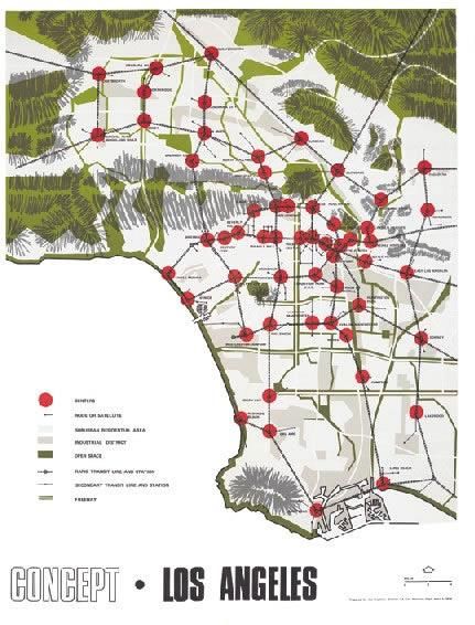
Table of Contents
Preface ................................................................................................................................. 1

Table of Contents ................................................................................................................ 2

Executive Summary .............................................................................................................3

Introduction.........................................................................................................................5

Measuring Congestion ........................................................................................................ 8

Land Use, Rapid Transit, Density, and Traffic ................................................................. 10

More Space for Driving: Constructing Highways and Freeways ..................................... 17

Inducing Demand with Improved Capacity ..................................................................... 22

Legislating Traffic by Regulating Driving ........................................................................ 23

Legislating Traffic by Regulating Land Development ..................................................... 28

A Common Engineering Measure of Congestion ............................................................. 29

Communicating Better Information about Driving ......................................................... 32

Ridesharing and Telework ................................................................................................35

Congestion Pricing: Has Its Time Come? .........................................................................37

Pricing Types and International Comparisons ................................................................. 41

Conclusion ........................................................................................................................ 43

About the Authors .............................................................................................................45

Notes ................................................................................................................................. 46

                                                                    2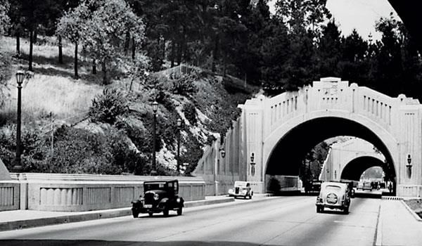
Executive Summary

      The Los Angeles Metropolitan Transportation Authority (Metro) started studying
congestion pricing in late 2019 as a way to manage the region’s heavy traffic and
unpredictable travel times. Unusually light traffic during the recent pause in economic
and social activity because of COVID-19 has highlighted the contrast between the usual
traffic and surprisingly free flow. Traffic is a byproduct of vibrant economic and social
activity and when L.A. rebounds, congestion is likely to return. The uncertain path to
economic recovery makes this an opportune moment to consider future policy options
that are effective and equitable.
      As policymakers consider arguments for and against dynamic pricing of road travel
and review pricing programs in more than forty other cities, they should also be
informed by insights from countless alternative approaches to congestion reduction
tried in past decades right here in Southern California. This white paper documents the
region’s persistent struggle to reduce congestion and explains why it has increased in
spite of these programs – and sometimes because of them.
      Travel patterns in Los Angeles predate the advent of the automobile. In its early
decades, electric street railway companies encouraged decentralization and literally
built the early suburbs to decongest the urban core. Population grew rapidly just as cars
became widely available and early transit suburbs increasingly attracted auto owners.
Traffic growth slowed streetcar service and the city imposed a wide variety of
regulations to reduce congestion, banning horses, left turns, street parking, and jitneys.
Signals and, much later, computers programmed to “optimize” flow all aimed to make
traffic flow smoothly. Streets were widened, parking garages added, tunnels, viaducts,
and freeways built, subways started, and busways constructed. Better information
guided travelers to their destinations, starting with police in blimps directing traffic and
moving on to helicopters, radio traffic reports, and ultimately sensors in the pavement
linked to communications centers and smartphone apps directing individual drivers.
Officials sincerely informed the people they served that each innovation would fix the
city's traffic congestion, but history shows that traffic flows grew each time they
expanded the transportation system.
      Each past innovation seemed promising, but traffic is complex and it confounded
every effort to reduce it. Where improvements made traffic flow more smoothly, people
adjusted the times, places, and modes by which they traveled, and congestion returned.
Land was developed where road and transit capacity encouraged growth and that
created more traffic. Concentrating development in dense activity centers to reduce
traffic fostered neighborhoods that generated more auto trips per acre. Dispersing
communities to reduce traffic led to fewer trips per acre but longer car trips and less
transit use. Dense traffic flows slowed bus service in the city and in the suburbs transit
was slow, infrequent, and costly to provide.
      Dynamic road pricing, now being studied by Metro, is not a new idea. It was first
proposed a hundred years ago and has been advocated by both progressives and
conservatives ever since. Proposals to manage traffic in Los Angeles must respond to the
land use and transportation landscape that resulted from past programs that we hardly
remember. The greatest challenges to dynamic road pricing relate to conflicting views of
fairness and equity in a city currently focused on inequality and racism, but past and

                                             3
current mobility options in Los Angeles are not obviously more fair or equitable than
those being studied. We do not propose a particular form of congestion pricing nor
suggest where it might be implemented. History demonstrates that dynamic road
pricing is worthy of serious consideration because it complements earlier approaches to
control traffic. Carefully implemented and informed by experiences long forgotten by
many, it can enhance mobility for automobile and transit travelers, lessen the harm
done to congested neighborhoods, and charge rich and poor people more fairly for their
transportation regardless of their race or ethnicity.
Find a comprehensive timeline accompanying this report at the Luskin Center for
History and Policy website, or at this link.
4Introduction
“The alarming increase in street accidents and in street
congestion during the past few years has rendered the correction of
traffic conditions one of the most important municipal problems of the
present day.”
Miller McClintock, 19252
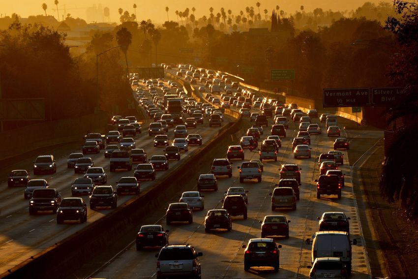
Los Angeles is searching for new ways to address the region's persistent problem of
recurring traffic congestion. More than forty cities abroad, including Oslo, Stockholm,
Singapore, and London, have proven that congestion pricing facilitates movement and
has the support of rich and poor residents. In 2019, the Board of Directors of the Los
Angeles County Metropolitan Transportation Authority (Metro) approved studies to
assess the feasibility of reducing traffic by charging different prices at different times
and places for driving on streets and roads in Los Angeles. One month later, the
Southern California Association of Governments (SCAG) released the results of its own
long-term congestion pricing study. Five years of data collection and community
engagement led SCAG to recommend a pilot project for West Los Angeles within a
specific area they are calling the "GO Zone."
Controversy is sure to follow, for drivers will initially resent paying to use streets
and roads that have long been free to them. They might also worry that road pricing will
fail to function as promised, that trip times will remain unpredictable, or that pricing
will be unfair to people with low incomes. COVID-19 adds to these concerns because
public health authorities required the city and its economy to go into a partial
"lockdown." Results included deep economic recession, growing numbers of evictions,
unacceptable unemployment, and free-flowing traffic. From newspaper columns to
television talk shows, media personalities have voiced amazement at the road conditions
and wondered whether pre-COVID-19 city life can resume, but without the traffic. One
writer in the Los Angeles Times likened this moment to Copenhagen in the 1970s, when
rising oil prices led a wave of residents to adopt bicycle commuting. Here in the US, with
streets so much less congested due to the pandemic, national bicycle ridership has risen
21%, and the author asked whether "some U.S. cities are on the brink of a Copenhagen
remodel?"3
Congestion pricing, first proposed over a century ago, consists of variable charges
levied on drivers in exchange for access to streets or roads at their times of peak usage.
It prevents traffic jams by convincing drivers unwilling to pay a high rush hour toll to
use another cheaper route, switch to transit, or postpose their trip to a cheaper time.
Beyond a handful of toll roads in Orange County and High Occupancy Toll (HOT) lanes,
Greater Los Angeles has rarely experimented with anything akin to congestion pricing.
Local leaders since the 1920s have seen "congestion not as an excess of cars but as a
scarcity of street space, to be remedied by the supply of street capacity."4
The solution to the problem, if framed this way, seems clear. To fix a street too
often jammed with cars we widen it, build another street or road parallel to it, impose
new rules to enforce efficient traffic flow, or to tell drivers when and where to avoid
5congestion. Unfortunately, these solutions, all tried many times, have only delayed the
recurrence of congestion. Economist Anthony Downs coined a Law of Peak-Hour Traffic
Congestion: potential travelers will notice fluid traffic on previously clogged routes and
then refill the road to its point of "maximum capacity."5 This has come to be known as
induced demand. In the forty cities that have congestion pricing, adjustable costs
respond to consumer demand and reduce traffic, increasing the efficiency of movement
by preventing drivers from overburdening road space.
Slow traffic scared officials in Greater Los Angeles regularly for a century. They
seemed to think congestion might stop the city's proverbial heart. They were anxious
that economic growth might cease and visitors might not return to the city recalling an
awful experience. Committees in and outside of government were convened to make
sense of this problem by gathering evidence and debating the next steps. A few themes
dominated thinking about traffic reduction throughout the history of the city, and we
present each of them in this review. The first theme was land use planning.
Developers created a structurally decentralized city to escape from traffic, but with time,
a New Urbanism promoting density to overcome traffic came into vogue. These two
opposite visions for the city were each supposed to alleviate traffic. Neither worked.
Another persistent theme was roadway construction. Los Angeles is famous for the
results: wide boulevards and wide freeways where commuters could speed to work.
Congestion endured. A third strategy was traffic management. A city traffic code
gave priority in the streets to cars, trucks, buses, and motorcycles. A “freeway revolt”
against huge and costly projects prompted traffic engineers to write new laws to modify
driver behavior. Land use regulation was adopted to control the degree to which new
housing and offices created new trips. Despite these efforts the streets remained
clogged. Over time, the city turned to new communications and information
technology. Authorities relayed updates about traffic conditions to drivers, and
engineers adjusted synchronized systems of street light to optimize flows. Information
technology was used to match travelers by their work locations and commute times so
they could share rides or replace work trips by telecommuting. Even these
cutting-edge innovations did not bring an end to recurring traffic jams.
We devote a section of this paper to each of these themes, examining its 100-year
history in and around Los Angeles. This allows us to illustrate how authorities often
revived the same traffic reduction tactics, from land use zoning in both the 1920s and
1960s and laws to modify driver behavior in the 1920s and 1980s. These long trends,
demonstrate what author Norman Klein has said - that Los Angeles has a "history of
forgetting." Policies of the past which did not work adequately - or at all – illustrate our
short collective memory. At best, officials have convinced themselves that yesterday's
failures might become today's successes because the city had changed dramatically in
the time since.6
During the thirties engineers plotted freeway routes under the assumption the
population growth of Los Angeles had steadied. They could not foresee the postwar
boom in suburbanization that filled land tracts with young families driving multiple cars
per household. New population overwhelmed transportation systems built for fewer
drivers, and critics claimed, despite many prior plans, that Los Angeles was an outcome
of unplanned sprawl. Erasing memories of past plans for traffic reduction in Los Angeles
ensured that planners to come would not learn well enough from mistakes local
6historians knew well.7 That is precisely why this history must be central to current
considerations of congestion pricing. The next six sections are histories of policy in
practice. They demonstrate the repetition in each of the themes as Los Angeles
confronted traffic over a century. Where possible, we document levels of congestion at
different times, but doing so accurately is impossible. Over a century, data were
collected using different methods in different communities having wildly different levels
of precision or accuracy. We rely to a far greater extent on accounts of perceived levels
of congestion and published plans to address it than on empirical measures of traffic
flows at particular times and places.
To inform studies and a public debate about the possible future of congestion
pricing in Los Angeles, we conclude with the history of congestion pricing as a policy
intervention that has often been proposed but never adopted in Los Angeles. The
technology to enable an efficient system of road charges did not exist during most of the
time period we studied. Theorists developed models in anticipation of a time when
vehicles would incorporate necessary communications capacities. Open the Lyft or Uber
app on your smartphone and plot the same trip during rush hour and in the middle of
the night, and see for yourself that we have the ability to price trips differently in real
time depending on traffic. Massive retooling of all vehicles is not needed. Hand held
transponders are widely used now. A Metro app installed on smartphones, would allow
the agency to price trips to lower congestion, confirm which drivers are in carpools, and
grant price reductions to vehicles carrying passengers with disabilities or having
qualifying low incomes. An early version of road charging is already in effect on three
facilities: Express Lanes on the Riverside Freeway (SR 91), the Harbor Freeway (I-110),
and the San Bernardino Freeway (I-10). This paper shows how thinking about pricing
has helped these three facilities work and addresses the potential of road pricing to be
more broadly applied to benefit auto commuters and those traveling in buses on the
same streets and roads.
People usually respond rationally to incentives and disincentives. Roads and
transit are costly to provide, and we have paid for them indirectly through gasoline taxes
and sales taxes while keeping the price to drive nearly zero. Policies like congestion
pricing have the potential to rebalance the scales and give drivers incentives to consider
carpooling, telework, public transit, bicycling, or living within walking distance to work
and shops. In the meantime, congestion pricing along streets with bus lines and
bicycling lanes promises more reliable scheduling to the transportation system's most
vulnerable population: people without the capital or the ability to drive at all. In Los
Angeles and Orange Counties 61% of people who use public transit have no cars
available and their buses are slowed by streets crowded by cars.8 Transit-dependent
people have far lower incomes than typical drivers in Los Angeles yet we expect public
transit to charge fares. If peak hour bus trips were not priced the vehicles might become
so crowded that they would not function adequately for those making essential trips to
work or school. Technological advances make it possible for the first time in a century to
apply similar logic to roads and autos.
7Measuring Congestion
What causes congestion?
Congestion occurs when the number of vehicles using a road exceeds its
capacity... “Recurrent congestion” occurs because of work schedules, scheduled events,
and regular hours of business operations.
“Episodic congestion” occurs because of unpredictable events including crashes,
spilled truck loads, broken water mains, and construction projects. This type of
congestion can appear at places and times that normally flow freely.9
Speed and Flow
When addressing congestion, we measure:
a) Speed: The distance covered by vehicles in a traffic stream per unit of time,
commonly stated in miles per hour.
b) Density: The number of vehicles on a section of roadway. For example, the
number of cars in a lane in one mile.
c) Flow: The number of vehicles passing a point in a unit of time. For example, the
number of vehicles that drive past a marker on the road in a minute.
The relationship between these factors were developed by B.D. Greenshields in
1933. The shapes of Figures 1 and 2, while generated from real-world data, hold true
across a variety of roadways.
Figure 1. The relationship between speed and density. (Occupancy is a reliable proxy for
density when traffic states are unchanging.)
This data, from Caltrans’ Performance Measurement System (PeMS), shows data taken
from part of the I-405 in 2018. The measure on the horizontal axis, occupancy, is a good
estimate of density when traffic conditions are relatively unchanging.
As shown in Figure 1, cars are able to drive at high speeds when volume is far below
capacity, since there are few other cars on the road. This is known as free-flow speed. As
8more cars are added, this has only a small influence on the speed of travel. As cars
continue to be added, speed begins to drop as the roadway becomes more crowded until
traffic is at a standstill. The point marking the sharp decline in speed is the critical
density. Figure 1 shows that:
1) When cars are traveling at free flow speed and more cars are added the flow
increases.
2) Flow continues to increase until the critical density.
3) Every additional car now lowers speed on the roadway.
4) Since cars are traveling slowly when traffic is dense, fewer cars overall are
passing a given point on the roadway.
5) The relationship between density of traffic and speed is non-linear.
Figure 2 shows the relationship between speed and flow. As described above, flow
increases until the roadway reaches capacity then begins to decline.
Figure 2. A diagram of the “backward bending” speed-flow relationship. Dots between
the two “branches” of the curve indicate a measurement taken as the road became more
or less congested. (Data points are averaged across five minute intervals.)
When relatively few cars are traveling, but each moves at high speed, the flow can be the
same as when the road is crowded with many vehicles moving slowly. This diagram
shows that near the roadway’s capacity, only small changes in the overall demand on the
roadway can greatly increase or decrease its speed. While specific numbers vary by
roadway, this case illustrates the relationship just described: If 160 vehicles extend over
a mile of roadway, and each is traveling at 5 miles per hour because the road is quite
congested, then 800 vehicles are traveling over that roadway per hour. When the road is
un-congested, the speed rises to 40 miles per hour. While there are only 20 vehicles per
mile, the flow is also 800 vehicles per hour.
9Figure 3. Photograph of Fletcher Drive and the Pacific Electric bridge by Herman Schulteis, ca. 1938
Land Use, Rapid Transit, Density, and Traffic
“Great as has been the increase in population, buildings and
property values, vehicular traffic has increased even faster.”
Frederick Law Olmsted, Harland Bartholomew, and Charles
Henry Cheney, 192410
Los Angeles is said to have heavy traffic because of what many call its “car
culture.” People in this region are believed to own more cars, love them, and drive them
more than people in most other places. That belief is mistaken. America is auto
dependent and Los Angeles is not unusual. Car ownership in Los Angeles, about 1.8 cars
per household, is about the same as ownership rates in Seattle and Cincinnati, 11 cities
not thought to be especially car oriented. According to the Federal Highway
Administration, residents of the Los Angeles-Long Beach-Anaheim Urbanized Area
drive about 22.3 miles per capita per day, about the same amount of daily travel as
people living in Akron, Ohio, and half as much per day as those in Beaumont, Texas. 12
Akron and Beaumont are not known all over the world for their traffic congestion.
10Furthermore, Los Angeles’ transit ridership is third among all cities in the nation behind
New York and Chicago13. While there would be many benefits to increasing transit use
here, doing so would not eliminate congestion. Blaming congestion in Los Angeles on a
love of cars ignores the fact that large cities all over the world experienced traffic
congestion for centuries even before the automobile was invented.
Traffic congestion in Los Angeles reflects the city’s development patterns which
influence travel to a greater extent than car ownership and use. People travel between
homes, jobs, schools and shopping centers. The location and density of those activities
determines the number of trips made and the lengths of trips. A study by the RAND
Corporation concluded that Los Angeles stands out among U.S. cities by being both one
of the most densely populated and one of the least centralized.14 Its large population and
successful economy lead to many trips, but its “polycentricity”– the dispersion of centers
of activity rather than a single, concentrated downtown – means those trips are both
long and difficult to serve by rapid transit. Ironically, the dense yet decentralized L.A.
metropolitan area was created by past programs and projects intended to support public
transit and cope with traffic. As Los Angeles grew, real estate developers, reformers, and
politicians wanted to enable families to escape from downtown congestion by
encouraging suburban decentralization. Others, often at the very same time, sought to
counter traffic resulting from “urban sprawl” by encouraging centralization and
increased density. A century of
promoting decentralization and
centralization to fight traffic has made
Los Angeles a city of “dense sprawl.”15
The debate between concentration and
spreading of development continues
without resolution today. Its century-
long history demonstrates that adjusting
the patterns of incremental or new urban
development cannot alone resolve traffic
congestion in what is now a large
metropolis that can change only very
gradually.16 Los Angeles grew most
dramatically as its transportation system
experienced rapid evolution. In 1870, the
county’s small town population of 5,000
people relied on horses to power wagons
and streetcars. By 1910, its burgeoning
urban population of 320,000 moved
about in cable cars, electric streetcars,
the first automobiles, and early buses.
Land developers, exemplified by railroad
heir Henry Huntington, made vast
fortunes buying land outside the center
Figure 4. Advertisement for land subdivision in Los of town, building rail lines to it, and
Angeles, illustrating the prominence of railway selling lots for homes and businesses
access in the promotion of real estate. away from the crowding and horse-
11pollution of downtown yet accessible by Humanity demands that man should
streetcar to its business and cultural have sunlight, fresh air, the sight of
attractions. Life in outlying areas was grass and trees. It demands these things
advertised as idyllic and appealing to for the man himself, and it demands
families seeking the healthful fresh air. As them still more urgently for his wife and
small, dispersed communities near transit children. No child has a fair chance in
stops grew larger and spaces between the world who is condemned to grow up
them filled in, growing auto travel in the dirt and confinement, the
produced persistent traffic congestion. 17 dreariness, ugliness, and vice of the
Low density development, facilitated by poorer quarter of a great city. . . There
investments in transit, encouraged is, then, a permanent conflict between
families to buy automobiles that clogged the needs of industry and the needs of
the streets as their numbers grew. Auto humanity. Industry says men must
registrations in Los Angeles County aggregate. Humanity says they must
increased tenfold in the ten years between not, or if they must, let it be only during
1914 and 1924, from 50,000 to half a working hours and let the necessity not
million.18 Service on rail lines, located in extend to their wives and children. It is
the streets, slowed as their tracks were the office of the city railways to
overrun by cars, so people bought more reconcile these conflicting requirements.
cars to escape the increasing unreliability
of the transit service. Many of the Charles Horton Cooley, A Theory of
inequities we observe in the region’s Transportation, Publications of the
settlement patterns began to take shape American Economics Association, 1894
as people of means, mostly white, moved
to suburbs and poorer people, including
many members of minority groups, remained in more crowded downtown locations.
Rich car owners complained of congestion that clogged streets in poorer urban
neighborhoods.
In 1924 the city council and the county board of supervisors agreed to share the
cost of hiring a firm of experts to prepare a comprehensive transit plan for Los Angeles.
The Chicago firm of Kelker, DeLeuw, and Company in 1925 submitted the Report and
Recommendations on a Comprehensive Rapid Transit Plan for the City of Los Angeles.
The plan called for the construction of 26.1 miles of subways and 85.3 miles of elevated
railways during the next ten years and proposed many miles of feeder bus lines and bus
routes in outlying areas.19 Reflecting growing regional rejection of centralization and
growing distrust of “downtown” interests, C.A. Dykstra in a 1926 essay refuted the
report’s suggestions, associating rapid transit with the centralization of the city’s
development. Transit had played the leading role in spreading the city out, but its high
capacity to move people came to be seen as essential to strengthening downtown
businesses. Dykstra, the future City Manager of Cincinnati and later UCLA Provost,
asked “why begin, particularly if there is adequate territory to care for a constantly
growing population.” Dykstra believed Los Angeles could best address its traffic
congestion problem through the development of low-density neighborhoods, in his
words, “beyond its frontiers.”20
Zoning came into being in the twenties, playing an important supporting role by
reinforcing the emerging dominance of the multi-centric city. The power to create
12zoning ordinances was granted by the state to municipal governments, weakening the
power of county authorities to control development patterns in incorporated areas.
Zoning in outlying communities limited residential and commercial building heights
and densities. By requiring as many as two or three parking spaces in each new dwelling
and a parking space per employee in businesses, zoning simultaneously lowered the
density of communities and created incentives to depend on autos by offering free off-
street parking at most locations.21
Though the regional rail network had failed to obtain voter support in the 1920s
and decentralization accelerated as the city grew, the hope of concentrating
development at greater density around public transit never died and remains alive
today. The Los Angeles Chamber of Commerce vigorously promoted an underground
and elevated rail transit system soon after traffic resumed its unrelenting growth in the
wake of the Great Depression and World War II. Voters defeated a 1948 initiative the
Chamber called “Rail Rapid Transit Now” even though its supporters claimed that traffic
would soon strangle the city unless it was approved. 22 Voters living in the San Fernando
Valley saw no need to tax themselves to bring business to downtown land owners. 23 The
Los Angeles Chamber, committed to a Los Angeles with a dense, concentrated urban
core, continued to favor mass rapid transit when it announced a new ten-year plan
called Destination ‘70 in May 1961. The Chamber’s Transit and Traffic Committee
promoted mass transit as a means of slowing growth in traffic congestion because it
provided the “only alternative to driving.” In the run-up to the November 1968
elections, the Chamber acknowledged that freeways alone were not enough to manage
traffic, associated freeways with low density sprawl, and argued that “a major
supplementary and complementary system of mass transportation must be built as soon
as possible.” To fund the $2.5 billion plan to build eighty-nine miles of rail, Proposition
A proposed a half-cent hike to the local sales tax. Even a vast coalition, featuring vocal
support from the mayor and Governor Ronald Reagan, could not get the historically
anti-tax and largely suburban population to vote “yes.”24 The Chamber of Commerce
was widely perceived to be promoting its own interest by facilitating permanent
downtown growth and regional dominance at the expense of the county’s strong and
growing suburbs.
After this setback, City Planning Director Calvin Hamilton cast the contrast
between long-competing visions of Los Angeles in stark relief as a denser, downtown
and transit-oriented, traditional city versus the unique suburban paradise now straining
under continued growth. His visionary 1970 plan called Concept, Los Angeles, proposed
an urban form that was a compromise between the two poles and addressed popular
concerns about worsening traffic congestion. A spatial mismatch between government,
business, and financial offices concentrated at the core and commercial services in the
suburbs would require more commuters to take long trips, but they would be served by
transit links and freeways connecting the centers. Travel appropriate to L.A.’s unique
form meant that an
…increased number of automobiles operated by the growing population
will require the continuous addition of freeways, major highways, local
streets and parking lots, just to keep congestion from getting worse. More
and more land will be used for street purposes and will be removed from
13the tax rolls...buses will compete with automobiles for space on the City’s
crowded streets and freeways.
Concluding with a few lines about the worsening air pollution that was becoming a
vexing regional challenge, the report acknowledged that traffic was far more than a mere
annoyance. Congestion had the potential to decimate the city’s revenue, disrupt surface
public transportation, and do great harm to the health of its residents and the beauty of
its environment. The root of the problem and the source of its solution was to be found
in the rearrangement of activities in space linked by fast, high-capacity transportation.25
Figure 5. Regional Centers and Transit Blueprint from the Concept Los Angeles General Plan
The solution Hamilton offered was the concentration of economic and political
functions into dozens of high-density “centers” throughout the region. Linked by both
freeways and rapid transit facilities, the dispersed but dense centers would be
14surrounded by low-density neighborhoods of single-family homes. The concentrated yet
dispersed nuclei would help reduce traffic congestion. Residents of suburban low
density areas would drive to “park and ride” lots in the centers where they would board
rapid transit that operated on “separate rights-of-way” to reach other centers, including,
but not only, downtown. His plan also called for placing freight railroads from the ports
below street level and designating “truck routes” on some freeways. The report predicted
optimistically that “Peak-hour congestion on major suburban streets will be
substantially alleviated by the diversion of commuting traffic to the rapid transit
system.” Even though most of the designated centers already existed, Hamilton’s plan
never came close to completion. As a compromise between concentration and
dispersion, it perfectly reflected the region’s persistent indecision.26
Yet another ballot measure that would have supported construction of a rail rapid
transit “starter line” failed to win voter support in 1974. This proposal concentrated rail
investments in downtown and the Wilshire Corridor to the west and, yet again, faced
opposition from outlying communities which opposed central city interests. Given these
repeated failures at the hands of suburban voters’ skepticism over the benefits of
increased taxes to pay for rail transit, maverick Democratic County Supervisor Baxter
Ward argued that a decentralized regional transit network was a better match to the
region’s needs. In 1976 Ward spearheaded two ballot measures – Measures R and T for
“rapid” and “transit - to increase the sales tax in order to build and operate the Sunset
Coast Line, a light rail network to be located mostly in the median strips of freeways and
on abandoned former rail lines. His twin measures, one to approve the concept and one
to raise the revenue, both failed badly, after being vigorously opposed as inadequate by
both downtown interests and still skeptical suburban opponents. 27
Reeling, but learning, from repeated voter rejections, Los Angeles finally acquired
revenue needed to begin constructing a regional rail rapid transit system when voters at
last approved a half-cent sales tax in 1980. Designed, like Calvin Hamilton’s plan, in
recognition of the regional tensions between centralization and decentralization, the
measure ingeniously committed a portion of the tax revenue to a regional rail network
but also funded bus operations throughout the county and provided for freeway
improvements. Key to its success was the inclusion in the measure of money in the form
of “local return” to every city in the county to repair its local streets and roads and/or
operate its own bus system. All local governments had suffered dramatic property tax
losses following the passage of Proposition 13 in 1978, so they supported the measure
primarily to get their share of the revenue, and the adoption of a regional rail system
came with it.28 Three more half-cent sales taxes, following the model of providing
“something for everybody” were approved by L.A. County voters in 1990, 2008, and
2016. Each imitated Proposition A by combining investments in a regional rail system
with local and decentralized transportation funding. 29 The still developing regional rail
network eventually will link many communities that would have been served by the 1924
and 1948 proposals and will connect many of the centers named in Calvin Hamilton’s
plan. Today, planners and advocacy groups continue to promote concentration, arguing
that public transit reduces traffic growth by encouraging high-density mixed-use
development near station sites, but there continues to be vocal opposition as well.
In 1988, the Southern California Association of Governments added a new
dimension to the discussion of urban form and traffic. SCAG published a study arguing
15that building more lanes or levels of traffic would not ease congestion as much as would
increasing the region’s “jobs-housing balance” to encourage commuters to reside closer
to where they worked and shopped.30
Echoing observations that earlier had led Calvin Hamilton to propose the Centers
plan, it was noted that many suburbs in the Los Angeles region were primarily bedroom
communities while others were primarily job centers. Throughout the eighties SCAG’s
regional plans increasingly asserted that the region would become more efficient if
future jobs were to be located near existing housing and new housing concentrated
closer to centers of employment. Jobs-housing balance was promoted to increase
economic opportunity, promote efficiency and equity, and reduce traffic by shortening
work trips.31 Many communities strived to increase their jobs-housing balance, and
quite a few, like Santa Monica, have done so, but there is little evidence that more
“balanced” communities have reduced congestion in comparison with less balanced
ones. New housing units may not meet the needs or suit the budgets of people working
near them. Many households include multiple workers, so living near the work location
of one family member may lengthen the commute distance of another. Work trips
account for less than a fifth of all household trips and workers choose their residential
locations based on many criteria in addition to proximity to work, such as the quality of
schools and proximity to recreational opportunities.32
The long struggle to define the future of Los Angeles continues. Many advocate the
New Urbanism and transit-oriented communities, while other groups in Los Angeles are
equally committed to slowing the growth in development density that enables that
vision to be attained. For the sake of reducing traffic congestion, community and
homeowners’ organizations repeatedly have fought proposed changes in zoning and
developments intended to create higher density mixed use centers that support rail
transit, on the grounds that traffic congestion will inevitably worsen if density rises. 33 In
the next section we review efforts to address growth in traffic congestion by increasing
street and road capacity, including an enormous commitment to freeway building that
changed the nature of Los Angeles in many ways. After reviewing commitments to
enhancing capacity, we also will examine the region’s ongoing efforts to manage
congestion by regulating the use of streets, highways and vehicles. Because an important
component of efforts to address traffic through regulation entail the regulation of land
use, we will revisit the theme of urban form in relation to traffic as well.
16Figure 6. Left image is Arroyo Seco Parkway, then and now, 1955. Right image is Arroyo Seco
Parkway as it opened, 1940.
More Space for Driving: Constructing Highways and Freeways
"All authorities agree that the congestion is primarily caused by
insufficient street area. This is readily apparent when figures are
consulted and Los Angeles is shown to have the smallest percentage of
street area of any of the large cities of America."
Los Angeles Traffic Commission, 192234
As the century-long disagreement about relationships between transit and urban
form went on, Los Angeles continually expanded roadway capacity in the pursuit of
congestion relief. The broad parallel boulevards west of downtown were intended to end
congestion as the city expanded toward the ocean in the 1920s. Between the 1930s and
17the1980s freeways greatly multiplied the region’s capacity to move cars and trucks. They
relocated and disrupted the lives of hundreds of thousands of families, eliminated entire
communities, concentrated motor vehicle emissions in other, mostly minority
communities, but were deemed “necessary” because of the congestion relief provided by
more roadway space, grade separation, and limited on and off ramps. Today, most
drivers in L.A. know that relief from congestion by building freeways was short lived.
J.B. Lippincott was known for the role he played in building a mammoth
aqueduct from the Owens Valley to Los Angeles. Having left the Interior Department to
serve as traffic engineer for the Automobile Club of Southern California, he conducted
“the most complete study of traffic conditions ever made in the West” according to the
club’s magazine, Touring Topics, which reported the results in 1920. Engineers
interpreted traffic flows on their maps as a call from drivers for expanded infrastructure.
Careful observations of 15 busy intersections between Los Angeles and surrounding
cities “proved” that the major culprit for congestion was not automobiles traveling from
one side of the city to the other through downtown, but rather the suburban commuters
who drove daily into the city. Stressing that a disproportionate number of drivers began
their journeys in Glendale, Eagle Rock, and Pasadena and then became trapped at the
city’s northeastern Pasadena Avenue-Avenue 20 intersection, Lippincott recommended
building an alternative route “through or around Elysian Park.”35 His traffic survey
became the inspiration for the Figueroa Tunnels, completed in 1931, later incorporated
into the Arroyo Seco Parkway.
Before 1920, the Automobile Club, the Business Men’s Cooperative Association,
officers of the Pacific Electric Railway, and members of the city council all had
addressed traffic, concluding that Los Angeles had severe congestion primarily because
it had an inadequate street system. Proponents pointed out that Washington, D.C., at
the time devoted 44 percent of its central city area to streets and San Diego’s downtown
devoted 41 percent of its area to streets, while Los Angeles’ central area had narrow and
discontinuous streets amounting to a mere 21.5 percent of its total downtown land area.
Widening and extending streets would help automobile and transit commuters alike,
argued the Traffic Committee of the Chamber of Commerce, since both modes shared
the streets.36
Such thinking led Los Angeles to commission several surveys, the most notable
leading to A Major Traffic Street Plan in 1924. Expert designers came from the east and
mid-west to diagnose the “traffic congestion problem” in Los Angeles as the worst in the
U.S. They identified a downtown “congested district” and recommended fixing it by
expanding and improving the supply of street space radiating outward. The most
expensive highway projects of the 1920s were bridges over the Los Angeles River into
East Los Angeles. During this period, traffic commissioner Miller McClintock, decried
Los Angeles for its “unscientific width and arrangement of streets.” 37 Historian Peter
Norton traced the evolution of McClintock’s thinking from a time when he thought
“widening streets would merely attract more vehicles” to favoring more street capacity.
Automobile companies seeking to increase car sales paid experts to do studies that, not
surprisingly, concluded cities needed to provide their inhabitants more street space to
accommodate more vehicles. After auto manufacturer Studebaker funded McClintock’s
traffic research institute at the Southern Branch of the University of California, later
18known as UCLA, his outlook evolved, and he began asserting a newfound belief in “the
inevitable necessity to provide more room” for the coming flood of cars.38
Figure 7. Figueroa Street Tunnels before completion of the Arroyo Seco Freeway
Traffic engineers, like water engineers, saw congestion like the problem of
flooding, and the projects they proposed for speeding traffic even overlapped at times
with flood control infrastructure. The first freeway in Los Angeles, the Arroyo Seco
Parkway – a road in a wide landscaped right-of-way that later was renamed the
Pasadena Freeway, before returning to its original name, ran parallel to a runoff channel
until it bypassed the bottleneck Auto Club surveyors had identified just north of
downtown and coursed into the Figueroa Tunnels. Along the route, drivers were to enjoy
the view of beautiful open space. Long before the first freeway’s 1940 completion, the
director of the California Real Estate Association made a case for its construction to the
Los Angeles Times in 1931. He heralded “traffic arteries free from crossings at grade,”
which “would tremendously speed up that traffic which seeks to proceed from the coast
to the interior valleys.” The label “freeway” was derived from this description.
By 1937, a commitment to increasing street capacity was made in the Auto Club
Engineering Department’s Traffic Survey: Los Angeles Metropolitan Area. A club
officer wrote an introductory letter explaining that the city’s “growing congestion...is the
direct result of an attempt to serve both abutting property and through traffic upon the
same street or highway.” Los Angeles needed not only more roads but ones next to
vacant strips of land, which we now call shoulders. The Survey blamed roadside
development, which “directly or indirectly retards the movement of vehicles,” by
encouraging drivers to stop. The club asked the public sector to assume responsibility
for land government should purchase to keep it free of commercial development or
housing. Auto Club engineer E.E. East later sharpened the criticism of roadside
19entrepreneurs who exacerbated congestion in an essay for Los Angeles: Preface to a
Master Plan. East believed that “business owners demand signals to slow traffic past
their door,” for “[t]hey see new, heavy investments jeopardized because traffic moves
too quickly to their downtown competitors.”39
An opportunity for the government to expand Los Angeles’ transportation
network and accelerate the speed of traffic arrived when the war economy coincided
with the New Deal of the 1940s. Freeways for the Region was published in 1943 by the
Los Angeles County Regional Planning Commission. From an article calling it “A Master
Freeway Plan for Los Angeles,” readers learned what this new space exclusively for
automobile driving would be like. The Times foretold “the unkinking of no-longer-
tolerable traffic snarls in many parts of the city and its metropolitan environs,” and the
report promised that experts would “search for routes in position to give relief to areas
where the greatest need existed prior to 1942, the last date for which normal traffic data
are available.” The streets had grown more congested in new industrial suburbs where
wartime aircraft production had boomed. Maps showed where congestion had
worsened, and those areas became priorities for freeway access. Two examples were the
San Fernando Valley neighborhood to the northwest of downtown and the southeastern
corridor passing through Downey, homes respectively to Lockheed and Vultee Aircraft,
two huge wartime employers.40
The framers of Freeways for the Region favored building “facilities which are
deliberately designed for the decentralized community, but that design does not need to
increase the destructive aspects of decentralization.” Drivers could in the future choose
from a variety of routes the type of road most suitable to their trip. Freeways would
serve drivers seeking to go as far and as fast as possible with few distractions. The report
even called for a ban on billboards facing freeways because they would distract drivers’
attention. Drivers could turn onto local streets when seeking places to shop or to stop
for a social call. The plan did not claim to bring an end to congestion, however. It
acknowledged the limitations of freeways, predicting that even these routes would
eventually become congested. “The time gained on the freeway would be lost in the
greater congestion produced within the business district. One can even imagine cars
‘backing up’ on the freeway itself and interrupting the constant flow of traffic.” If the
County’s population growth stabilized at six million, the planners thought the region
might avert such a dismal future.41 Only some of the proposed freeways were built and
the current county population exceeds ten million people, so today’s congestion was well
within their sight.
To accommodate increasing popular demand for highway capacity, the federal
Bureau of Public Roads developed a “traffic-service” model to predict where heavy
traffic flows were likely to occur. Using tools developed in the interwar period, in what
might be termed the golden age of traffic surveying, “origin-destination” data were
gathered from randomly sampled motorists and plotted on maps of metropolitan areas
like Los Angeles. They provided planners and engineers with “desire-line maps” that
connected areas having the largest number of trip origins with the most frequent
destinations. Lines on maps connecting popular origins with common destinations
suggested where road capacity could most directly benefit drivers, but largely failed to
analyze the communities they crossed or consult with their residents. Passage of the
Federal-Aid Highway Act of 1944 initiated three years of postwar recovery spending on
20roads. A quarter of the new funding was earmarked for urban routes and Los Angeles
received its share. Almost ten years later, a planner from California could look back with
pride and see “the wisdom of local planning agencies in anticipating a complete network
of freeways to adequately serve the tremendous desire for motor vehicle travel in the Los
Angeles Metropolitan Area.”42
Planning for high capacity long-distance roads advanced with the Collier-Burns
Highway Act of 1947, which committed fuel tax revenue to the building of rural roads
and urban freeways. More driving increased fuel purchases which in turn funded more
road construction that enabled more driving. This model for funding and administering
roadwork later served as a “template for the 1956 federal legislation,” which funded the
U.S. Interstate Highway System. Motor fuel taxes were user fees akin to tolls, though
less costly to collect, securing for states the resources needed to pay an enormous
workforce to build this infrastructure. In exchange for accepting federal and state
money, metropolitan leadership agreed to accept state and federal design standards.
Reflective of rural highways, required designs implemented by state engineers rather
than local officials prioritized traffic efficiency, driver safety, speed, and saving money
on land purchases. Many Los Angeles freeways cut wide and straight or gently curving
paths through a number of the city’s lowest-income areas. Serving high volumes of trips
to downtown led to building high densities of freeways closer to downtown just as the
spokes of a wheel become denser near the hub. Inner city homes and workplaces
belonging to members of blue collar communities disappeared after experts assessed
their land as having low cost and remade it into space for driving. 43
Highway construction and community destruction accelerated through the
1960s, when more miles were under construction than at any time before or since. 44 In
the 1970s, clashes now known as “freeway revolts” arose as urban and suburban
neighborhood groups organized in opposition to freeway building in their communities.
Community activists, homeowners’ associations, environmentalists and preservationists
joined forces, fighting freeways for different reasons. Freeway building required
considerable use of eminent domain and demolition, especially harmful in
neighborhoods of color. Preservationists committed to the protection of the city's
remaining historical districts, beloved parks, and open spaces with sensitive ecosystems
were joined by the few communities of color that remained undisturbed..45 Route 2, the
Beverly Hills Freeway, for example, was cancelled after opposition grew among
disparate groups along its entire route, from Silver Lake to Century City. Some entire
future routes were deleted from official maps of the planned freeway system in the face
of a burgeoning social movement opposed to the destruction of neighborhoods to
improve traffic flow by expanding road capacity. In less than a quarter century ̶ the
time it takes to design a freeway, acquire property, clear its path, and build it ̶
perceptions of freeways had evolved from the belief that they provided needed capacity
to satisfy travel demand to condemning them as intrusions creating the traffic
themselves.
21Inducing Demand with Improved Capacity
New or improved traffic routes suffer from what has been described as a “triple
convergence,” by economist Anthony Downs in his book Still Stuck in Traffic. When
traveling, most people want to minimize their travel time. If a congested route is
widened, travel time decreases. People who formerly used alternatives converge onto the
improved route. Other people who travelled before or after the most congested time
period to avoid delays also switch onto that route, and the times at which they travel
converge. Because travel times have decreased, some people who used other travel
modes, like public transit, switch to cars. More drivers use the route, until they cause
traffic to move more slowly, eliminating the advantage provided by the new capacity.
Drivers then switch off the newly expanded route onto parallel routes or onto transit or
they change their departure times until the travel time between the new route and its
alternatives is roughly the same and there is no benefit to choosing a particular route or
its alternative. When no route confers a particular time advantage, all routes are likely
congested or circuitous.46 In London, surface street traffic moved at the speed that a
century ago made journey times roughly equal by car and by underground, and that
remains true today.47 In Los Angeles, many have noted that after a project to widen I-
405 through Sepulveda Pass that took years to complete, traffic seems as congested as it
did prior to undertaking that project, though the widened route was to service a larger
number of travelers.
22You can also read