A Contemporary Geographic Issue - AGGS Geography
←
→
Page content transcription
If your browser does not render page correctly, please read the page content below

A Contemporary Geographic Issue

A contemporary issue refers to an issue
                        that is currently affecting people or places
                        and that is unresolved.

A geographic issue refers to a topic,
concern or problem, debate, or
controversy related to a natural and/or
cultural environment, which includes a
spatial dimension.
Aspects of a contemporary geographic issue refers to the
nature of the contemporary geographic issue and the
values and perceptions that relate to the issue

There are THREE parts to this topic:
1. The nature of the issue. This refers
to the spatial dimension of the issue
(can you map it?), the effects of the
issue on the natural and/or cultural
environment, who does it affect?

                                 2. How people’s values and
                                 perceptions have led to their
                                 responses – What do they think
                                 and why do they think that? (could
                                 be individuals or groups)
3. Proposing a suitable course of action to address the
issue and justify it. What do you think is the best solution
and why?
To gain a better
understanding of
different perspectives
and values in
Geography, complete
Chapter 5 (pages 32 –
38) in your skills book.

Discuss your answers
in small groups.

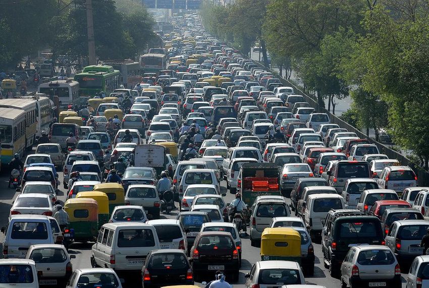
What is the issue with traffic
congestion in Auckland?
Why is it an issue?

How does this issue affect you
and/or your family?
World’s 20 cities with the
worst traffic jams
What number is Auckland?

Study the map of
Auckland on page 12
of the Atlas.
What are the issues
with the geography
of Auckland in terms
of transportation?

Auckland is an
‘awkward’ shaped
city for transport. It
is located on an
isthmus (a narrow
strip) with two
harbour’s and many
volcanoes and inlets.
Read the article ‘How one crash caused gridlock chaos’
In the article highlight the following (in different colours):
• The issue
• People’s viewpoints on the issue
• Suggested solutions

                            VIDEO: How one crash caused gridlock
Where do you think this picture is from (HINT: It is somewhere in
Auckland!)
This is Lower Queen Street in 1919, with
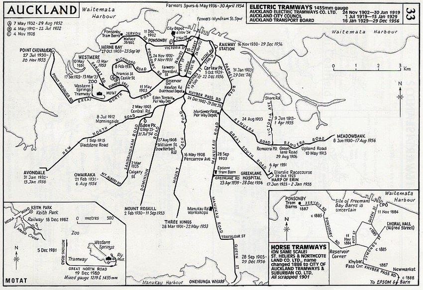
trams, cars and horse-drawn taxis visibleRead the information sheet “History of Early Auckland’s Transport Networks” Annotate your map of Auckland with information that you have just read (use the Atlas to help you pin-point specific suburbs)
EXAMPLE of Answers
                               First tram line from CBD to
                               Ponsonby in 1902              Growth originated
Ferries connected CBD to
                                                             around harbour
North Shore

Overcrowding = people
moving outwards =
trams

New suburbs due to
reliable transport and
urban growth
                                                      End of trams, start of main
                           First railway – Queen      motorways in 1950s
                           Street to Onehunga
                           1873
What types of transportation can you see in the following images of ‘Old Auckland’
Queen Street, 1885
Onehunga, 1873
Corner of Queen Street and Victoria West, 1883
Looking along Queen Street towards Customs
               Street, 1900
Karangahape Road, 1910
Karangahape Road with Queen
  Street on the right, 1930s
Karangahape Road
Queen Street
What do you think replaced trams and trains in Auckland in the
 1950s?
                    Cars
                                       How do you think cars
                                       changed the transport
                                       networks AND traffic
                                       congestion in Auckland?

                                        People moved outwards
                                        because they could now
                                        drive into the CBD.
                                        More roads/motorways
                                        built.
                                        Trams disappeared from
                                        the roads.
                                        More traffic jams due to
Broadway,Newmarket 1950                 increase in cars
In the 1950s the Auckland Harbour Bridge was built so people could drive more directly from the CBD to the North Shore and so that people could live on the North Shore and still work in the CBD
VIDEO: The Auckland
   Harbour Bridge
Less than 10 years after it opened
traffic congestion meant the
Auckland Harbour Bridge was
extended to create more lanes and
therefore more cars could use the
bridge.
As the city spread,
motorways were built
around Auckland
VIDEO: Auckland’s
Motorways 1950s/1960s
What is this graph showing?
What problems can you see for the future from this graph?
What geographic concept could you apply to your explanation of
what this graph is showing?
“Worsening traffic
congestion will inflict
significant economic and
social costs on Auckland”

What do you think this
means?
What are the economic and
social costs of traffic
congestion?
Did you know ….
• 200,000 vehicles travel on the Southern Motorway each weekday.
• An average 168,500 vehicles now cross the Harbour Bridge every
  day, compared with 17,000 in 1960 shortly after it opened.
How does traffic congestion affect you?
What suburb do you live in and how long did it take you to get to
school today? Why?
As you look at the following five maps showing morning traffic
congestion in Auckland - what patterns do you see? Also think
about what problems these patterns are creating.
Auckland’s
traffic at
7.15am on a
Thursday
morning

 Source:
 www.nzta.govt.nz
Auckland’s
  traffic at
  7.30am on a
  Thursday
  morning

Source:
www.nzta.govt.nz
Auckland’s
 traffic at
 7.45am on a
 Thursday
 morning

Source:
www.nzta.govt.nz
Auckland’s
traffic at 8am
on a
Thursday
morning

Source:
www.nzta.govt.nz
Auckland’s
traffic at
8.30am on a
Thursday
morning

 Source:
 www.nzta.govt.nz
Study this graph. How has transport expenditure impacted
on Auckland’s traffic congestion?
Employment
growth is
increasing in the
City Centre.

What does this
mean for
traffic
congestion in
Auckland?
Residential high-density buildings constructed within the last
decade have helped to increase the population living in the CBD to
from 1,400 in 1991, to 16,000 in 2004 to 40,000 in 2010.

                                      What does this mean for
                                      traffic congestion in
                                      Auckland’s CBD?
Auckland’s population is forecast to reach around 2.5 million
people by 2041.
What will this mean in terms of traffic
congestion in Auckland?Pressure on already crowded bus networks …
Employment and residential numbers in the city centre are
expected to almost double by 2041. Employment to more than
200,000 people and residential to 140,000.
Car travel times to the city centre from the
southern growth area are likely to increase
by 25 minutes between 2021-2041.

                                               HOW do you
                                               think this will
                                               impact on people
                                               and WHAT will
                                               the consequences
                                               be?
Projected demand flows (AM peak) on the road network in 2041
WHAT does this map
show?It has been predicted that by 2041:
• Buses won’t be able to meet demands and vehicle speeds in
the city centre will halve in the morning to walking speed.
• Private trips to the city centre from some areas will take up to
twice as long.
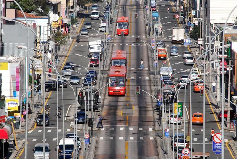
• Trains will be at capacity.Public transportation that works: Curitiba, Brazil Curitiba’s bus system is referred to as one of the world’s most efficient. Cities like Los Angeles, Las Vegas, Bangalore have modelled their bus systems with inspiration from Curitiba. In 2010 the city was even awarded with the Globe Sustainable City Award.
Minibuses go through through
residential neighbourhoods and
feed passengers to conventional
buses on circular routes around
the central city and on inter-
district routes.

The backbone of the system is composed of the Bus Rapid Transit,
operating on the five main arteries leading into the centre of the city
like spokes on a wheel hub.
                                             VIDEO: Curitiba
                                   Glass-covered platforms allow the
                                   bus company to have the all the
                                   passengers ready to board as the
                                   bus arrives. Payment is taken care
                                   of as the passengers enter the
                                   platform. The price is fixed and
                                   relatively cheap.
What could Auckland learn from Curitiba?
Hong Kong
90% of all travelling is done
by mass transit.

The 7 million daily riders
have access to something
known as an "octopus card"
which is accepted as currency
not just to move them
around the city, but also at
parking meters, convenience
stores, and fast-food
restaurants.
London
In London people have to pay an £10 daily Congestion Charge if you
drive between 07:00 and 18:00, Monday to Friday in the Congestion
Charge zone

                                                       VIDEO:
                                                       London
                                                       Congestion
                                                       Charge – has
                                                       it worked?
Auckland
The Northern Busway links the North Shore
 with the north end of the Auckland Harbour
 Bridge

In 2010 the busway was estimated to remove the equivalent of about
5,100 cars in the morning peak, with 80 buses per hour during peak
times
What do you think are the viewpoints of the following
people around Auckland’s transport?

• The Minister of Transport (Gerry Brownlee)
• A business man who lives in Ellerslie and works on
  Queen Street
• An Auckland Girls Grammar Student who catches the
  school bus
• The Mayor of Auckland (Len Brown)
• A teacher at Auckland Girls Grammar School who has a
  large number of late students each day
• A parent who has a child in daycare in Albany and works
  in the CBD.
                       WHY do you think they have this viewpoint?
HOW could the transport issue in Auckland be solved? Brainstorm this in groups.
Use the dice (Who,
What, Where, How
Why, When AND
Could, Should, Would,
Can, Might, Will) to
create 4 questions
around solving
Auckland’s traffic
congestion.
Can you answer them?
The City Centre Future Access Study (CCFAS) was commissioned
by Auckland Transport.
The study into the future transport needs of Auckland revealed a
looming crisis as the city’s population growth exceeds the ability
of the transport network to cope.

The world’s largest traffic jam happened in China in 2011. It stretched more than 100 km from
                                       August 14 to 26.
What options were developed?
(46 were evaluated and 3 put on the list of possible solutions)
Surface Bus This option delivers
some capacity, but
reaches its limits
between 2025- 2030
and costs up to
$1.13 billion.
Including
approaches also
entails significant
land take in
suburban Auckland.
It is the best of the
bus optionsUnderground Bus This option delivers some additional capacity, but reaches its limits between 2025-2030 and costs up to $ 2.34 billion. Including approaches also entails significant land take in suburban Auckland.
Underground Rail
Connecting to the existing rail network. This option delivers the
highest number of people, involves the smallest land take and has
the most beneficial impact on car commuters and freight. It is the
only option with any capacity after 2041. It is also the
most expensive capital cost option at $2.4 billion
VIDEO: City Rail Link
Sky Path

SkyPath will be a path
along the city side of the
Auckland Harbour Bridge
for pedestrians and cyclists.

 VIDEO: Sky Path
You can also read