GOVERNMENT OF JAMAICA NATIONAL WORKS AGENCY - Major Infrastructure Development Programme
←
→
Page content transcription
If your browser does not render page correctly, please read the page content below
GOVERNMENT OF JAMAICA
NATIONAL WORKS AGENCY

   Major Infrastructure
 Development Programme

     PROJECT PROFILE
                   for
        Hagley Park Road

          National Works Agency
    Directorate of Planning and Research
           140 Maxfield Avenue
                Kingston 10
               Jamaica, W.I.

             February 2018
1.0 INTRODUCTION
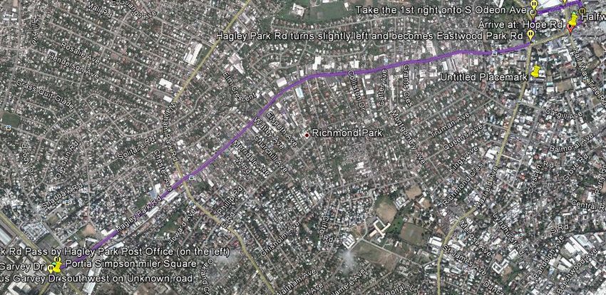
Hagley Park Road is approximately 3.4km in length and is the main thoroughfare
between Halfway Tree and Portia Simpson Miller Square. The roadway provides access
between primarily Portmore, Spanish Town and Halfway Tree.
2.0 BACKGROUND
The roadway has not seen any significant maintenance or upgrade over the last 30 years
despite the multiplication of traffic volume. The roadway currently carries traffic
volumes in excess of 30,000 vpd on some sections. The section with the highest volumes
is the four lane section 920m long from Portia Simpson Miller Square to Waltham Park
Road. The remainder of the roadway carries approximately 24,000 vpd all the way to
Halfway Tree.
Hagley Park Road serves a multiplicity of functions. It is firstly a major collector/
distributor where it meets with several local and major streets and secondly it has an
abundance of private and public businesses with direct access. Thirdly it is a major
arterial linking commercial and residential centers. Studies by NWA have identified this
corridor as one with the highest traffic interruption rates. This high interruption rate
results in very low efficiencies and resulting long travel times and delays. The roadway in
its present configuration is very susceptible to minor crashes/incidents which can easily
double travel times or force closure of the roadway.
The roadway has two cross sections. The western end is an undivided four lane dual
carriageway for a distance of 920 m with paved sidewalk on southern side only. The
remainder is a gently winding 2 lane road with access points every 20m or so with
sidewalks in some areas.
3.0 LOCATION
Hagley Park Road is at an elevation of 13 m at Portia Simpson Miller Square and rises to
80m at Half Way Tree. It follows a meandering west to east route passing through a
heavy mixed residential and commercial area.
2Figure 3:
4.0 EXISTING ROAD/ DESIGN
4.1 Traffic Count
The average annual daily traffic along the corridor during 2017 was approximately
30,000 vpd at the western end and 24,000 vehicles per day at the eastern end near to Half
Way Tree. Traffic is projected to grow 2 to 3% per annum and increase to 6% for the two
years following completion of the project due to the increased accessibility and reduced
vehicle operating cost and travel times. It is to be noted that traffic is suppressed due to
the restricted road capacity and considerable growth is expected once the corridor is
improved.
4.2 Design speed
The posted speed limit along this thoroughfare is 50km/h. From a safety perspective
control of speeds to no more than 50 km/h should be incorporated in the design due to the
numerous commercial access points and moderate pedestrian activity.
34.3 Grade
The terrain is gentle with a rise and fall in the range of 19m/km. This is a gently almost
imperceptible grade.
4.4 Horizontal Alignment
The horizontal curves satisfy the required sight distance for the posted speed limit of
50km/h.
4.5 Lane width
There are two lanes with widths of 4m and varying sidewalk/verge in the project area.
The proposed cross section will have four lanes of 3.35 m each and a 0.6m median with
minimum 1.8 m sidewalks.
4.6 Sidewalk Width
In many sections these shoulders have deteriorated due to lack of maintenance and utility
installations. Raised concrete sidewalks are to be provided in all sections. Where existing
sidewalks have deteriorated they are to be rehabilitated. A minimum width of 1.8 m is to
be achieved. Sidewalks are required in all areas being a highly urbanized area with high
pedestrian traffic.
4.7 Intersection Rationalization
Currently there are four traffic signal controlled intersections along the project length. It
is anticipated that these will require upgrading to accommodate the new width and
turning lanes. An additional three intersections are envisaged to be signalized to facilitate
major crossing streets/access points to ensure a modicum of access to the surrounding
communities and not to unduly lengthen journeys for Hagley Park Road destined traffic
4.8 Right of Way
There are structures and or privately owned parcels of land restricting the right of way
throughout the corridor.
This will entail the relocation of several boundaries and demolition of structures.
44.9 Wearing Surface
The existing wearing surface is Asphaltic Concrete. Most of the corridor is in fair to poor
condition (International Roughness Index of the order of 5.8m/km) except for a few small
areas. The corridor due to heavy patching of an old decayed oxidized asphalt pavement
has a quite rough and bumpy surface as evidenced by the IRIof5.8m/km. This unevenness
and other defects contribute to reduced operating speeds and frequent swerving/stopping
by motorists to avoid the worst areas as well as higher than desirable vehicle operating
cost.
4.10 Project Objective
The intended purpose of this project is to remove a major bottleneck that is a major
contributor to congestion on the main road network. This upgrade will increase the
capacity of this corridor by at least 60% and will complement investments made in
enhanced traffic management by the Government of Jamaica and ensure that its citizens
have reliable and efficient access between home, school, healthcare facilities and work.
The project is intended to address primarily
Pedestrian safety through a continuous pedestrian walkway and rails
Vehicle operating cost through an improved road condition, reduced
congestion
Reduced crashes better traffic management and traffic separation
Reduced travel time increased speed and reliability
Reduced congestion more capacity
Reduce shortcutting more capacity
4.11 DEMAND ANALYSIS
The demand for this project is fuelled by the increasing blockages along the corridor.
Studies undertaken by the NWA indicate that this corridor is severely affected by side
street and direct property access adversely affecting traffic flow resulting in tremendous
queues which block Hagley Park Road during peak periods. This corridor is one of the
5two main links for motorists from the west entering the city and is heavily congested
throughout the business day.
4.12 Scope of Works
The works planned for this roadway will entail the following:
1. Road Works is 3.7 km in length and will consist of:
a. Provide 4 x 3.35m driving lanes with 100mm thick asphaltic concrete
wearing course.
b. Provide 3.35m turning lanes at critical intersections
c. Provide 1 x 0.6m raised concrete jersey median barrier
d. Provide 2 x 1.8m raised concrete sidewalks.
2. Traffic management
a. Upgrade existing Three Miles at-grade signalized intersection with a grade
separated interchange consisting of a flyover bridge for Spanish Town
Road through traffic and a second flyover bridge for Hagley Park Road
through traffic. Turning manoeuvres will be signal-controlled at grade.
b. Upgrade existing traffic signals at Waltham Park Rd, Woodglen Ave and
Maxfield Avenue
c. Provide new traffic signals at Hagley Park Prep, Keesing Avenue, Omara
Road and Margaret Villa Road intersections
d. Installation of surveillance and Licence Plate Recognition (LPR) cameras
at signalized intersections
3. Other
a. Major drainage improvement along the corridor with the installation of
HDPE/concrete pipes
b. Streetlights on top of median jersey barrier
5.0 SOURCES OF MATERIALS
6All aggregates will be obtained locally from any of several quarries within 50km of the
project site
Asphalt/bitumen will be imported through PetroJam in the normal manner as this material
is not produced in Jamaica.
HDPE pipes, concrete pipes and the reinforced drop inlet boxes with gratings will be
procured from local suppliers.
Road marking and street signs will be supplied locally.
6.0 COST ESTIMATE
The Contract Sum is US$56,496,758.16
7.0 FEASIBILITY
The project cost developed above was used as the construction cost of the project
For this analysis a number of assumptions were made as listed below
The section to be improved has a length of 3.7 km and an existing
International Roughness Index (IRI) of 5.8m/km.
The annual average daily traffic volume on the corridor has been projected to
vary between 24,000 and 30,000 vehicles per day over its length.
The project life for the roadworks is forecasted for 20 years with a
construction period of 18 months.
7 average vehicle speeds would be 40 km/h
the newly constructed surface will have an International Roughness Index of
2m/km
A discount rate of 12% was used as well as a growth rate of 2% per anum for traffic.
8.0 FINANCING
The GOJ will provide approximately 15% of the funding for the project.
The remaining 85% will be provided by China EXIM Bank.
9.0 CASH FLOW
The project is expected to run for 18 months.
10.0 TIMELINE
The entire project is expected to be completed by October 2019.
11.0 ORGANIZATION
The NWA will manage the project through its Directorate of Major Projects.
8You can also read