A note on the Kabi Landslide, NorthDistrict, Sikkim on 03/08/2018
←
→
Page content transcription
If your browser does not render page correctly, please read the page content below
A note on the Kabi Landslide,
NorthDistrict, Sikkim on 03/08/2018
by
P.K. Shrivastava, Director,
Ram Ratan Singh, Senior Geologist
L. Sarjesh Singh, Geologists
Geological Survey of India, North-Eastern Region, State Unit: Sikkim, Gangtok
A moderate scale landslide occurred in mid-July and reactivated on 2nd August 2018 near
Kabi area on the state highway, adjacent to the border between East and North Districts of
Sikkim causing disruption of traffic. The location is about 22 km from Gangtok on Gangtok-
Mangan road via Phoodong (Fig. 1). The coordinates of this landslide is 27°23′35″ N and
88°38′7″ E and the entire landslide area falls exactly at the boundary between East and North
districts of Sikkim having Survey of India Toposheet No. 78A/11. A visit was made on 3rd
August 2018 to the affected area and field investigation was carried out to assess the landslide
and evaluate the causative factors by a team comprising of P.K. Shrivastava, Director, Ram
Ratan Singh, Senior Geologist and L. Sarjesh Singh, Geologists, Geological Survey of India,
North Eastern Region, State Unit: Sikkim.
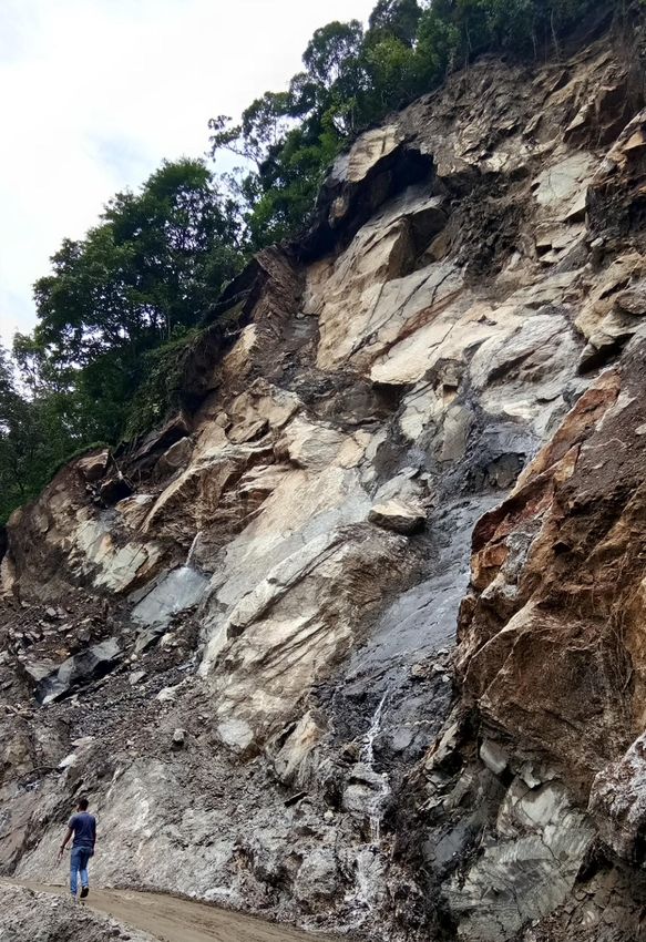
Preliminary field observation confirmed that the Kabi landslide was characterised by a
very rapid sliding movement along with fall of bedrock material along a steep slope (>70°; refer
Fig. 2), due to the action of gravity and flow of water through weak planes (Fig. 3), which
resulted in the accumulation of huge amount of rock debris. The dimension of this landslide is
having length of about 70m, width of about 60 m, and the depth to failure surface being 1- 5 m.
The run-out distance is about 120m (Fig. 4). The landslide is enlarging in nature. Observing the
nature of movement, rapidity and material moved, this landslide is termed as a rock slide, which
are quite common mostly in higher altitude areas of the Himalayas. The type of overburden is
fresh rock and soil having thickness of 1-3m. The rocks are highly fractured (Fig. 5). A
prominent discontinuity surface like joint planes and fracture planes have also been observed.
The landslide is active, enlargingand planner in nature. The surrounding area of the landslide
exposes streaky migmtitic gneiss and biotite+muscovite gneiss belonging to Kanchanjunga
gneiss of CCGC (Central Crystalline Gneissic Complex) along with basic intrusives. The
intrusives are at places showing concordant relationship with the country rock. The margins
between intrusive and country rock is sheared.
Following trends have been identified in the rocks:
Failure plane N80W/70 →S10W
Foliation NS/32˚→ E
Joint Planes J1: N75E/70˚→SE (with Slickenside)
J2: N15W/65˚→SW
J3:N40E/72→NW
The landslide is located in hinge zone, characterised by minor folding (Fig. 6) and dragging.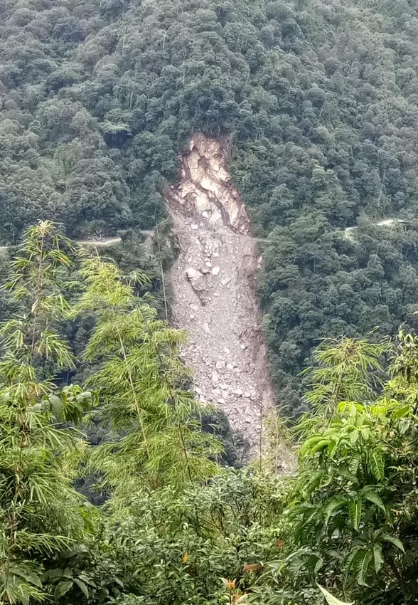
Geomorphologically the affected area was moderately to highly dissected with dense
vegetation cover. The area lies on the right bank of Rate-Chu stream. Since the landslide is still
active and intermittent movement of rock material is also observed, the entire zone of
accumulation area needs further investigation. During the current site visit, some overhanging
blocks have been observed which are likely to fall. There is an accumulation of debris, formed
due to this landslide going upto 120 m deep (approx.). Field observation shows that huge
material has already been mobilised due to this slide and rock along with debris have already
moved out from its active zone of depletion (natural hill slope) and chances of similar type of
major sliding activity in the vicinity area seems lesser except from the crown region, where
blocks are still in hanging position. Hence, further possibility of minor sliding activities in the
rainy season cannot be ruled out.
        Presently on the day of the present site visit, the landslide is active and movement of
material is going on intermittently, thus, close observation of its zone of depletion area can be
planned at later stage. The tentative geoscientific reasons of this landslide as observed could be i)
wedge failure, ii) heavy rainfall, iii) local fracturing, iv) joint and fracture water pressure
developed v) steeper slope morphometry.
        This landslide affected almost 70m of stretch of state highway but fortunately no
causalities took place despite this scale of natural calamity. The landslide is likely to reoccur as
cracks have developed in the upper region of hill, above the road.
        The 42-point Performa for this landslide is attached.

                                                 Kabi
                                                 Landslid
                                                 e

       Fig. 1: Location map of Kabi Landslide, North District, Sikkim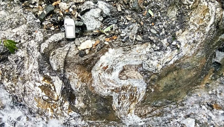
Fig. 2: Close view of Kabi Landslide.

Fig. 3: Flow of water through fracture & Joint planes
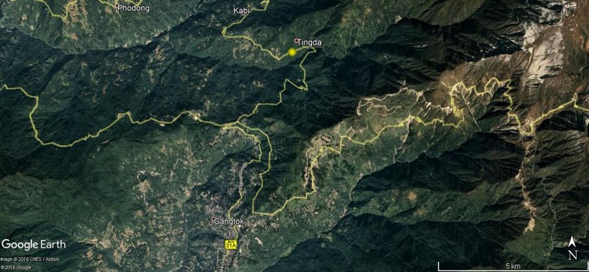
Fig. 4: Total length of Kabi Landslide from crown to toe.
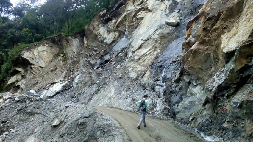
Fig. 5: Fracture planes, Joint Planes and overall Slip face of Kabi Landslide
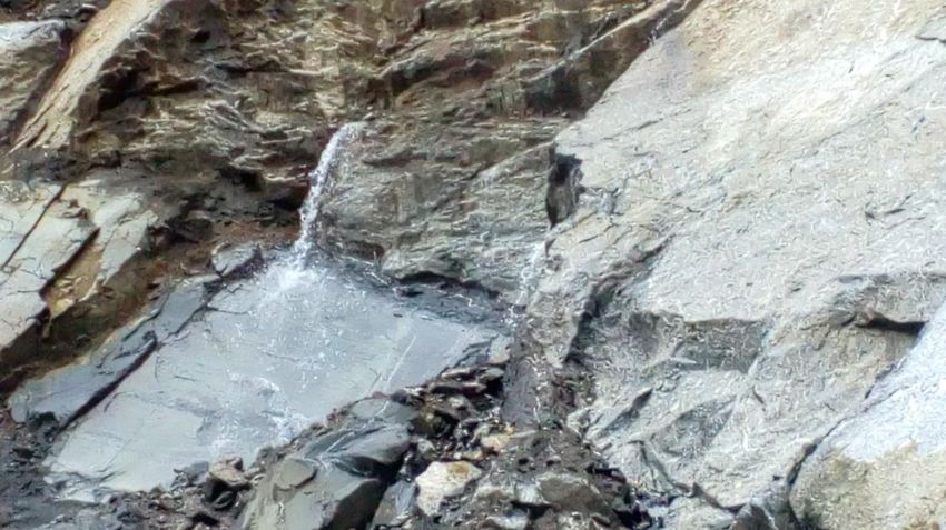
Fig. 6: Localised hinge area exposed on the slip face of Kabi Landslide

42-Point Geo-parametric Attributes of Landslides (Causes, Remedial Measures & Others)

No     Field                       Description
1      Slide No (LS .No.)          State: Sikkim/district: North District/toposheet: 78A/11/year:
                                   2018/serial no.
2      State                       Sikkim
3      District                    North District
4      Toposheet                   78A/11
5      Name of the slide           Kabi Landslide
6      NH/SH/Locality              State Highway; 4 km before Kabi village
7      Latitude                    27o23’35’’N
8      Longitude                   88o38’7’’E
9      Length                      70m (from the road)
10     Width                       60 m
11     Height                      60 m (from the road)
12     Area                         420 m 2
13     Depth                       1-5 m
14     Volume                      2100 m3
15     Run out distance            120 m
16     Type of Material            Rock
17     Type of movement            Slide
18     Rate of movement            Extremely Rapid
19     Activity                    Active
20     Distribution                Advancing
21     Style                       Single
22 Failure mechanism Shallow planar failure
23 History Date of initiation: Mid-July 2018
subsequent reactivations (02/08/2018)
24 Geomorphology Geomorphologically the affected area was moderately to highly
dissected with dense vegetation cover.
25 Geology The surrounding area of the landslide exposes streaky migmtitic
gneiss and biotite+muscovite gneiss belonging to Kanchanjunga
gneiss of CCGC (Central Crystalline Gneissic Complex) along with
basic intrusives. The intrusives are at places showing concordant
relationship with the country rock. The margins between intrusive
and country rock is sheared.
26 Structure Following trends have been identified in the rocks:
Failure plane N80W/70 →S10W
Foliation NS/32˚→ E
Joint Planes J1: N75E/70˚→SE (with Slickenside)
J2: N15W/65˚→SW
J3:N40E/72→NW
27 Land use/ Land cover Dense Forest
28 Hydrological condition Flowing seasonal stream
29 Triggering Factor The area is dissected by numerous weak planes. These weak planes
have provided conduit to the rain water creating hydrological
pressure, resulting in the failure.
30 Death of persons Nil
31 People affected None
32 Live stock loss Nil
33 Communication Road (blocked/damaged)
34 Infrastructure Nil
35 Agriculture/forest/Barren Dense forest
36 Geo-scientific Causes Combination of variety of failures (eg wedge and planer failures)
with pore water pressure
37 Remedial measures Removal of crown hanging blocks, making arrangement for proper
drainage and diversion of flowing stream,
38 Remarks, if any Road was blocked for about a week.
39 Photos. Sketch of Plan & Attached with the Preliminary note.
section of the slide
40 Summary/Abstract Attached with the Preliminary note
41 Pdf Nil
42 Landslide CategoryYou can also read