8:30 AM EDT Friday, July 2, 2021 Hurricane Elsa
←
→
Page content transcription
If your browser does not render page correctly, please read the page content below
Tropical Update
                                             8:30 AM EDT
                                          Friday, July 2, 2021

                                               Hurricane Elsa

This update is intended for government and emergency response officials, and is provided for informational and situational
awareness purposes only. Forecast conditions are subject to change based on a variety of environmental factors. For
additional information, or for any life safety concerns with an active weather event please contact your County Emergency
Management or Public Safety Office, local National Weather Service forecast office, or visit the National Hurricane Center
website at www.hurricanes.gov.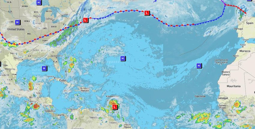
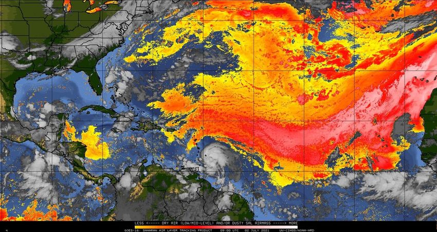
Atlantic Basin Satellite Image
Chance of development:   None   Low   Medium   High
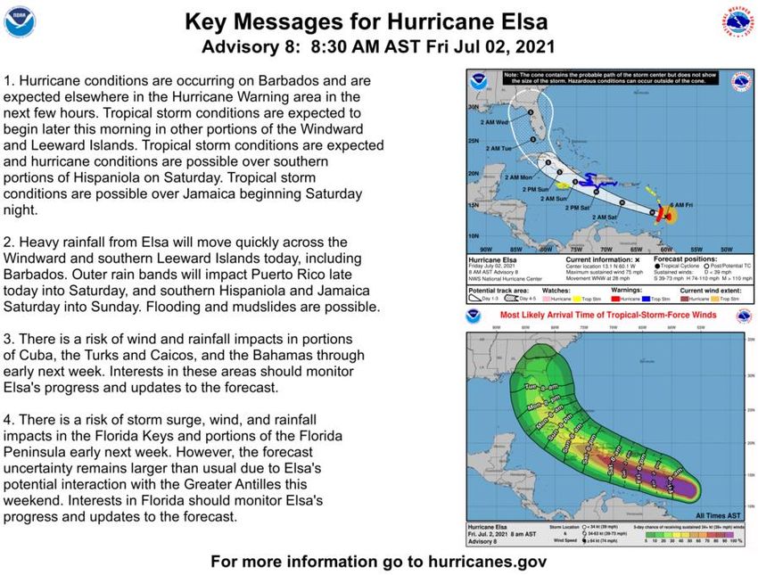
Official Forecast Track – Hurricane Elsa
From the National Hurricane Center – (LINK)
                              • At 7:45am EDT Friday, Elsa was upgraded to a
                                Category 1 hurricane with maximum sustained winds
                                75 mph. Little change is strength is forecast, though
                                some slight weakening is possible on Sunday due to
                                land interaction.

                              • The center of Elsa is located about 40 miles west of
                                Barbados or about 1,575 miles southeast of Miami.

                              • Elsa is moving quickly to the west-northwest at 28
                                mph, and this general motion is expected over the
                                next 2-3 days. A turn toward the northwest and
                                north is expected by Sunday or Monday.

                              • There remains SIGNIFICANT uncertainty in the track
                                and intensity forecast. This system should continue
                                to be closely monitored for impacts to Florida, but
                                interests are urged to not focus on the exact
                                forecast points.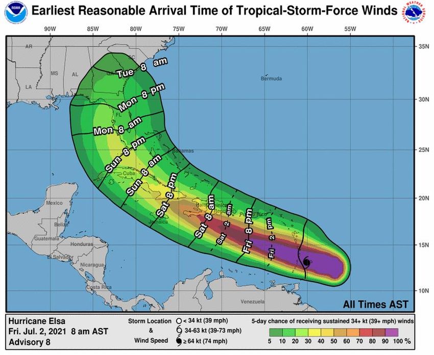
Color denotes the movement speed through
                Steering Currents            the atmosphere and thin white lines denote
                                                direction. Tightly clustered white lines
                What is Moving the System?       represent faster movement as well.

  A large area of high pressure
across the Atlantic will keep Elsa
  moving west-northwestward
    over the next 2 days. As it
approaches the western edge of
the high pressure ridge, a slower                                           Fast Steering
                                                                                Flow
 motion is forecast, along with a
     more northwest to north
            movement.
  When the turn north occurs is
 dependent on the strength and
   location of the Atlantic high
  pressure area combined with
     the next frontal system
 approaching the U.S. East Coast                                            Slow Steering
         later next week.                                                       Flow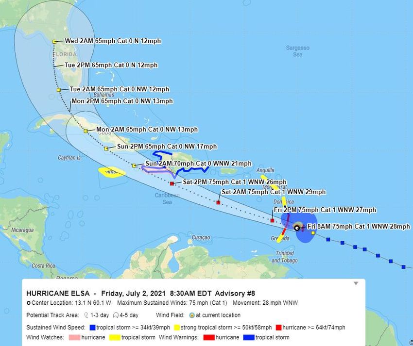
Model Forecast Tracks Next 5 Days
                Ensemble and Dynamical Models – Hurricane Elsa

There is higher than normal uncertainty in the track forecast beyond 3 days. Models split considerably by the time
Elsa makes it to central or western Cuba. Storm intensity would be guided by how much land interaction occurs. A
   more southern track in the Caribbean and western track in the Gulf of Mexico would favor a stronger system.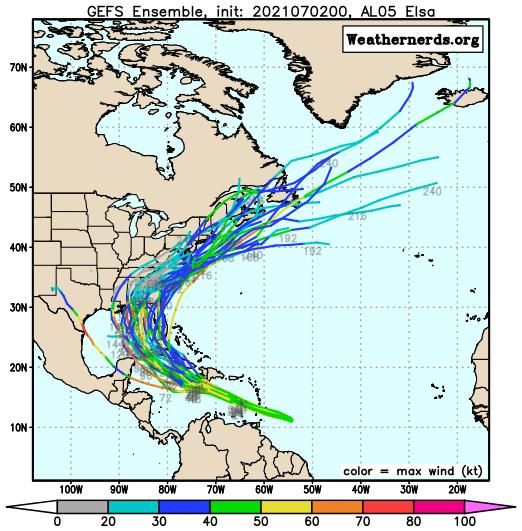
Dry Air & Saharan Dust                                           Color denotes concentration of
  Is the environment favorable for the system?                    Saharan Dust or dry, stable air.

                                    Dry air is becoming less of a limiting
                                  factor in Elsa’s development as it moves
                                           into the Caribbean Sea.

Moist                                                           Very Dry
                                      Dry
       Dry      Moist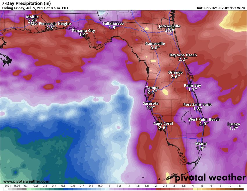
Color denotes the amount of wind shear and
             Wind Shear                                     the lines denote how it have changed over the
                                                              last 24 hours (dotted lines show decreasing
             Is the environment favorable for the system?        shear and solid lines show increasing.

     The environment is
 favorable around Elsa with                                                                  HIGH Shear
                                                                                            (Unfavorable)
low wind shear. Wind shear
  may increase as it moves
 through the Caribbean this
                                                                                             HIGH Shear
   weekend, but very high                                                                   (Unfavorable)
 wind shear is not currently
 forecast, which could favor                                                                 MODERATE
      some additional                                                                           Shear
       strengthening.                                                                         (Neutral)

                                                                                             LOW Shear
                                                                                             (Favorable)
Sea Surface Temperatures & Anomalies
             Is the ocean favorable for the system?
                                                                        °F
                                                                        90
                                                                        88
Water temperatures are warm enough                                      86
       to support a hurricane.                                          84
                                                                        82
                                                                        81
                                                                        79
                          Above Normal
                                                                        75
                                                                        72
                                                       80
                                         84           82
                                                                   77
                                                           82 81

                          Below Normal
Model Forecast Intensity
Dynamical and Statistical Models – Tropical Storm Elsa

                                   There is wide variability among the
                                     intensity guidance. This is due to
                                      uncertain interactions with any
                                  lingering dry air, wind shear, or land.
                                  Model guidance will be updated later
                                               this morning.
Time of Arrival & Wind Speed Probabilities
EARLIEST REASONABLE Time of Arrival of Tropical Storm Force Winds (>39 mph)
                                      City                             Chance for      Changes Since
                                                                       TS Winds        Last Packet
                                      Key West                         37%             +14%
                                      Marathon                         36%             +18%
                                      Naples                           33%             +17%
                                      Miami                            17%             +11%
                                      Ft. Lauderdale                   22%             +11%
                                      West Palm Beach                  20%             +12%
                                      Ft. Myers                        21%             +13%
                                      Tampa                            27%             +14%
                                      Orlando                          16%             +/-0%
                                      Apalachicola                     15%             +/-0%

                                        The earliest timing for tropical storm wind impacts could be as
                                     early as Sunday night in South Florida and during the day Monday
                                                    for the central and northern Peninsula.
                                     On the current forecast track, the most likely timeframe for tropical
                                        storm force winds is Monday afternoon/evening across South
                                      Florida and late Monday night through Tuesday for areas north of
                                     Lake Okeechobee. Given the uncertainty in the forward speed, the
                                       “Earliest Reasonable Time of Arrival” graphic should be used for
                                                       planning into the holiday weekend.
Rainfall Totals Next 7 Days
Ending 8 AM ET Friday (7/9/21)
Through Monday morning, most areas
across the Peninsula will see about 0.5-1.5”
from daily afternoon and evening
thunderstorms.
From Monday and beyond, an additional 2-
3” of rain is expected across the Peninsula
with about 1” across North Florida. These
totals are highly dependent on the track and
intensity of Elsa.
However, recent heavy rain across North
Florida and northern Central will make
grounds more susceptible to flash flooding,
should heavy rainfall occur. Drier soil across
the southern half of the state will require
heavier totals to pose a significant flood risk.Key Messages From the National Hurricane Center
Overall Summary
Hurricane Elsa
• At 7:45am EDT Friday, Elsa was upgraded to a Category 1 hurricane with maximum sustained winds 75 mph.
• The center of Elsa is located about 40 miles west of Barbados or about 1,575 miles southeast of Miami.
• Elsa is moving quickly to the west-northwest at 28 mph, and this general motion is expected over the next 2-3 days. A turn toward the
   northwest and north is expected by Sunday or Monday.
• Little change is strength is forecast, though some slight weakening is possible on Sunday due to land interaction.

Florida Outlook:
• The entire Florida Peninsula, Florida Keys and eastern Florida Panhandle are included in the day 5 forecast error cone, but no impacts to
     Florida are expected through Sunday afternoon.
• There remains SIGNIFICANT uncertainty in the track and intensity forecast. This system should continue to be closely monitored for impacts
     to Florida starting late Sunday or Monday, but people are urged to not focus on the exact forecast points.
• There are currently no hurricane-related watches or warnings for Florida, but based on current trends, watches could be issued for portions
     of South Florida sometime on Saturday.
• Strong winds, locally heavy rainfall, isolated tornadoes and storm surge impacts are possible for portions of South Florida and the Florida Gulf
     Coast, but specific details are not yet available.

The next briefing packet will be issued Friday evening. For the latest information on the tropics, please visit the National Hurricane Center website
at www.hurricanes.gov.
Tropical Update
Created by:
Amy Godsey, Chief State Meteorologist
Amy.Godsey@em.myflorida.com
State Meteorological Support Unit
Florida Division of Emergency Management
Users wishing to subscribe (approval pending) to this distribution list, register at:
https://public.govdelivery.com/accounts/FLDEM/subscriber/new?topic_id=SERT_Met_Tropics.
Other reports available for subscription are available at:
https://public.govdelivery.com/accounts/FLDEM/subscriber/new?preferences=trueYou can also read