Seasonal Climate Forecast Dec. 2020 - Feb. 2021
←
→
Page content transcription
If your browser does not render page correctly, please read the page content below
Seasonal Climate Forecast
          Dec. 2020 – Feb. 2021
                    Issued: November 19, 2020

           Contact: ODF Meteorologist Pete Parsons
         503-945-7448 or peter.gj.parsons@oregon.gov

Oregon Department of Agriculture (ODA) - Oregon Department of Forestry (ODF)
Production support: Diana Walker; Jacob Cruser; Andy Zimmerman; Julie Waters
El Niño Southern Oscillation (ENSO)
        Current Status and Forecast
n  The August – October 2020 Oceanic Niño Index (ONI) cooled
further into the La Niña range (-0.9°C).
n The ONI lags real-time sea-surface temperatures (SSTs), which have
cooled into the moderate La Niña range across the tropical Pacific.
n NOAA’s Climate Prediction Center (CPC) has issued a La Niña
Advisory and expects La Niña to continue at least through this winter.
n Tropical Pacific SSTs are much colder than they were the past two
autumns. El Niño conditions developed both of those winters.

IMPORTANT NOTE: Beginning with the October 2017 update, ONI values use ERSSTv5 data
(Huang et al. 2017, J. Climate, vol. 30, 8179-8205).

https://www.cpc.ncep.noaa.gov/products/analysis_monitoring/lanina/enso_evolution-status-fcsts-web.pdf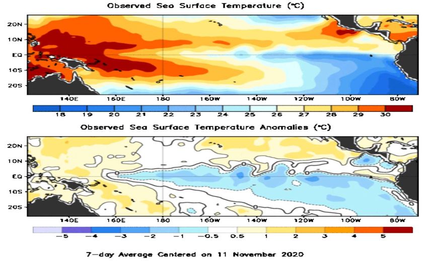
Forecast Highlights
n The analog-years (1959-60; 1970-71; 1995-96) are unchanged from last
month. Both 1970-71 & 1995-96 had La Niña events, during the late-fall
and winter periods, but 1959-60 stayed ENSO-neutral.
n Higher-than-normal amplitude in the upper-air patterns is likely,
which greatly increases the chances of Arctic outbreaks and valley snow.
Expect periods of significant storminess with ample mountain snowfall.
n  December may start out relatively mild and stormy, but the chances
for cold weather increase greatly after about Christmas.
n Important note: Prepare for markedly more volatile weather than we
had the past two winters, which were tempered by El Niño conditions.
IMPORTANT NOTE: This forecast is based on past and current weather data and is not
associated with CPC predictions (see “Forecasting Methods…” at: https://oda.direct/Weather) nor
the official CPC “Three-Month Outlooks,” which are available here:
https://www.cpc.ncep.noaa.gov/products/predictions/long_range/seasonal.php?lead=1
Pacific Ocean
     Animated (PowerPoint only) SSTs (top) / Anomalies (bottom)

           Tropical Pacific SSTs have cooled further into La Niña territory

Courtesy: https://www.cpc.ncep.noaa.gov/products/analysis_monitoring/enso_update/gsstanim.shtml
Tropical Pacific Ocean
                          La Niña Conditions Present

                   Current SSTs are in the moderate La Niña range)

Courtesy: https://www.cpc.ncep.noaa.gov/products/analysis_monitoring/enso_update/sstweek_c.gif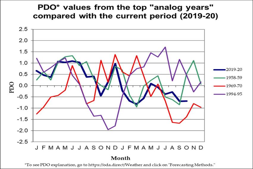
Tropical Pacific Ocean

(1958-59; 1969-70; 1994-95)     Aug. – Oct.
                              analog ONIs
  Strong   El Niño             ranged from
  Moderate                    ENSO-neutral
                                to La Niña
  Weak

      ENSO-neutral

  Weak
  Moderate                      Aug. – Oct.
                              ONI (-0.9°C)
  Strong   La Niña            cooled further
                               into La Niña
                                  range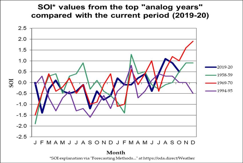
Tropical Pacific Ocean

(1958-59; 1969-70; 1994-95)    Oct. analog
                               SOIs ranged
      La Niña                 from La Niña
                                to ENSO-
                                  neutral

    ENSO-neutral

                                  Oct. SOI
                               (0.5) dropped
                              slightly, falling
      El Niño                     into the
                              ENSO-neutral
                                   range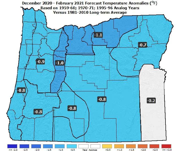
North Pacific Ocean
       (Poleward of 20°N Latitude)

(1958-59; 1969-70; 1994-95)
                                        Oct. PDO
                                     analogs ranged
            Warm                     from “Neutral”
                                        to “Cool”

            Neutral

                                       Oct. PDO
                                     (-0.70) stayed
                                      on the cool
             Cool                        side of
                                       “Neutral”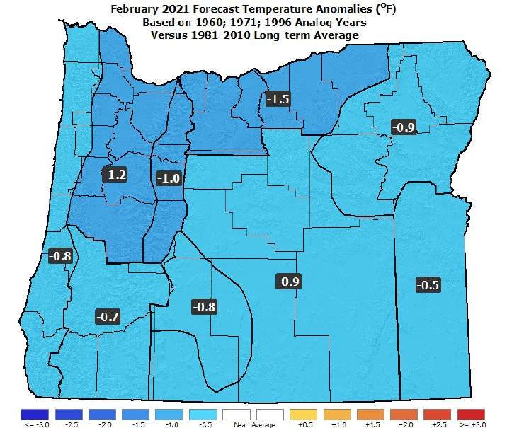
SST Anomalies Comparison
    Oct. Analog Composite                    October 2020

n   The SST anomalies from the October analog composite (left) and from
    October 2020 (right) have similar (cool) patterns. They show varying
    strengths of La Niña across the tropical Pacific.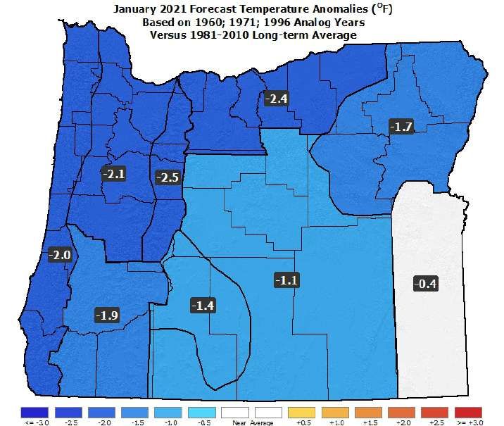
December 2020 Forecast
Mean Upper-Air Pattern                     Upper-Air Anomalies

n   Anomalous troughing is likely to set up just offshore, leading to lower-
    than-average snow levels over Oregon.
n   The above pattern favors increased storminess, especially for western
    Oregon, but it may have too much westerly flow for Arctic intrusions.
December 2020 Forecast
Temperatures Precipitation
n Analogs have high variability but generally show near or above-average
temperatures (severe cold snaps are not indicated).
n Near or above-average precipitation. Elevated chances for high-wind
events, especially along the coast and across the western zones.January 2021 Forecast
Mean Upper-Air Pattern Upper-Air Anomalies
n The analog years all had negative temperature anomalies over western
Canada, which opens the door for Arctic intrusions into Oregon.
n An enhanced jet stream and below-average upper-air temperatures
favors ample mountain snowfall & coastal wind/heavy-rain events.January 2021 Forecast
Temperatures Precipitation
n Above-average precipitation and near or above-average mountain
snow. Increased chances for windstorms, especially along the coast.
n Temperature forecast is less certain, with possible transitions between
stormy and cold periods. Western valley snow event(s) likely.February 2021 Forecast
Mean Upper-Air Pattern Upper-Air Anomalies
n Analogs still have considerable variation but favor negative temperature
anomalies over the Pacific Northwest.
n An enhanced jet stream and below-average snow levels should lead to
near or above-average mountain snowpacks.February 2021 Forecast
Temperatures Precipitation
n Above-average storminess likely. Heightened chance of heavy rain
events and flooding for western zones.
n Rapid transitions from cold/dry to mild/wet periods possible. Overall,
temperatures should be near or slightly-below average.Dec. 2020 – Feb. 2021 Forecast
Mean Upper-Air Pattern Upper-Air Anomalies
n Upper-level ridging will be more westward than usual, which will open
the door for cold air masses to drop southward, from the Arctic, into
the eastern Gulf of Alaska, western Canada, and the Pacific NW.
n A wide variety of weather patterns are likely during the period.Dec. 2020 – Feb. 2021 Forecast
Temperatures Precipitation
n Colder than average, especially after Christmas. Wetter than normal.
n Elevated chances for heavy rain, strong winds, above-average mountain
snow, cold-air outbreaks, and valley snow events, especially in January.Could it be the…?
Winter 2020-21 Highlights

n   Perhaps it won’t be the ‘Coldest Winter Since ‘78!,” but…
n   Unlike the past two years, this winter should have stormy
    period with some “extreme” weather events.
n   Expect relatively-mild temperatures in late fall, with a
    transition to colder weather, relative to average, by January.
n   Analogs favor at least one cold-air outbreak, with some
    snowfall in the Willamette Valley, especially in January.
n   Mountain snowfall should be near or above normal.
n   Heightened chances for windstorms and flooding across
    western Oregon, especially along the coast.
Oregon Department of Agriculture http://www.oregon.gov/ODA/programs/NaturalResources/Pages/Weather.aspx
Forecast Resources
n   CPC Official US Three-Month Forecasts (Graphics):
https://www.cpc.ncep.noaa.gov/products/predictions/long_range/seasonal.php?lead=01

n   CPC US 30-Day & 90-Day Forecasts (Discussions):
https://www.cpc.ncep.noaa.gov/products/predictions/long_range/fxus07.html

n   CPC Weekly & Monthly ENSO Discussions:
https://www.cpc.ncep.noaa.gov/products/analysis_monitoring/enso_advisory

n   Australian Government Climate Model Summary:
http://www.bom.gov.au/climate/model-summary/#region=NINO34&tabs=Overview

n   Australian Government ENSO Wrap-Up:
http://www.bom.gov.au/climate/enso

n   IRI ENSO Quick Look:
https://iri.columbia.edu/our-expertise/climate/forecasts/enso/current/

n   ODA Seasonal Climate Forecast Home:
http://www.oregon.gov/ODA/programs/NaturalResources/Pages/Weather.aspx
Water Supply Information
n   NDMC U.S. Drought Monitor:
https://droughtmonitor.unl.edu/

n   NIDIS North American Drought Portal:
https://www.drought.gov/nadm/content/percent-average-precipitation

n   NRCS Snow Water Equivalent Oregon Map:
https://www.wcc.nrcs.usda.gov/ftpref/data/water/wcs/gis/maps/or_swepctnormal_update.pdf

n   NRCS Snow Water Equivalent Products:
https://www.wcc.nrcs.usda.gov/snow/snotel-wereports.html

n   NRCS Weekly Water and Climate Update:
https://www.wcc.nrcs.usda.gov/cgibin/water/drought/wdr.pl

n   NRCS Western Snowpack Data & Water Supply Forecast:
https://www.wcc.nrcs.usda.gov/cgibin/westsnowsummary.pl

n   WRCC WestWideDroughtTracker:
https://www.wrcc.dri.edu/wwdt/
Updated Monthly
                    (Around the 20th)

    Your Feedback is Welcome!

  Sign-up for Email Notification of Updates at:
         https://oda.fyi/SubscribeSCF
    Contact: Pete Parsons, ODF Meteorologist
at 503-945-7448 or peter.gj.parsons@oregon.gov
     https://www.flickr.com/photos/canonshott/sets/72157654242713168
You can also read