Seasonal Climate Forecast August - October 2018 - Oregon.gov
←
→
Page content transcription
If your browser does not render page correctly, please read the page content below

Seasonal Climate Forecast
          August – October 2018
                        Issued: July 19, 2018

           Contact: ODF Meteorologist Pete Parsons
         503-945-7448 or peter.gj.parsons@oregon.gov

Oregon Department of Agriculture (ODA) - Oregon Department of Forestry (ODF)
 ODA Production support from Diana Walker, Jacob Cruser, and Andy Zimmerman
El Niño Southern Oscillation (ENSO)
        Current Status and Forecast
n  The Oceanic Niño Index (ONI) for April – June was -0.1°C, which is
in the ENSO-Neutral (average) range. The ONI lags real-time SSTs.

n  Current sea-surface temperatures (SSTs) are continuing to warm and
are near-to-above-average across most of the tropical Pacific Ocean.

n  The Climate Prediction Center (CPC) favors ENSO-neutral through
this summer with a 65% chance of El Niño (warm) conditions this fall.
Note: ENSO forecast skill is relatively low in the spring and early summer.

IMPORTANT NOTE: Beginning with the October 2017 update, ONI values use ERSSTv5 data
(Huang et al. 2017, J. Climate, vol. 30, 8179-8205).

http://www.cpc.ncep.noaa.gov/products/analysis_monitoring/lanina/enso_evolution-status-fcsts-web.pdf
Forecast Overview
n  The analog years (1985;1996; 2006) remain unchanged from last
month. They ranged from weakening La Niña to ENSO-neutral. All of
them continued to warm during their respective late-summers and
autumns. 1985 and 1996 remained ENSO-neutral through the
subsequent winter, with 2006 warming into a weak El Niño that autumn.

n Indications are that summer’s heat will get moderated by the second
half of August, with a shift to cooler-than-average conditions for the last
month of summer. By October, subtle differences in the upper-air
patterns of the analog years made a large difference in their resultant
weather, so forecast confidence decreases...

IMPORTANT NOTE: This forecast is based on past and current weather data and is not
associated with CPC predictions (see “Forecasting Methods…” at: https://oda.direct/Weather)
nor the official CPC “Three-Month Outlooks,” which are available here:
http://www.cpc.ncep.noaa.gov/products/predictions/long_range/seasonal.php?lead=1
June SST Anomalies (°C)
                  2018                         Composite: 1985; 1996; 2006
                                         Observed
                                      tropical Pacific
                                      SST anomalies
                                       showed a mix
                                      of both positive
                                        and negative

                                      Composite of
                                      analog tropical
                                       Pacific SST
                                      anomalies was
                                       still slightly
                                         negative

n   The June 2018 observed Pacific Basin SST anomaly pattern is similar to the
    constructed June composite of the current analog years (1985; 1996; 2006).
n   Both graphics still show some negative SST anomalies in the central and eastern
    tropical Pacific Ocean but warmer SSTs relative to the previous month.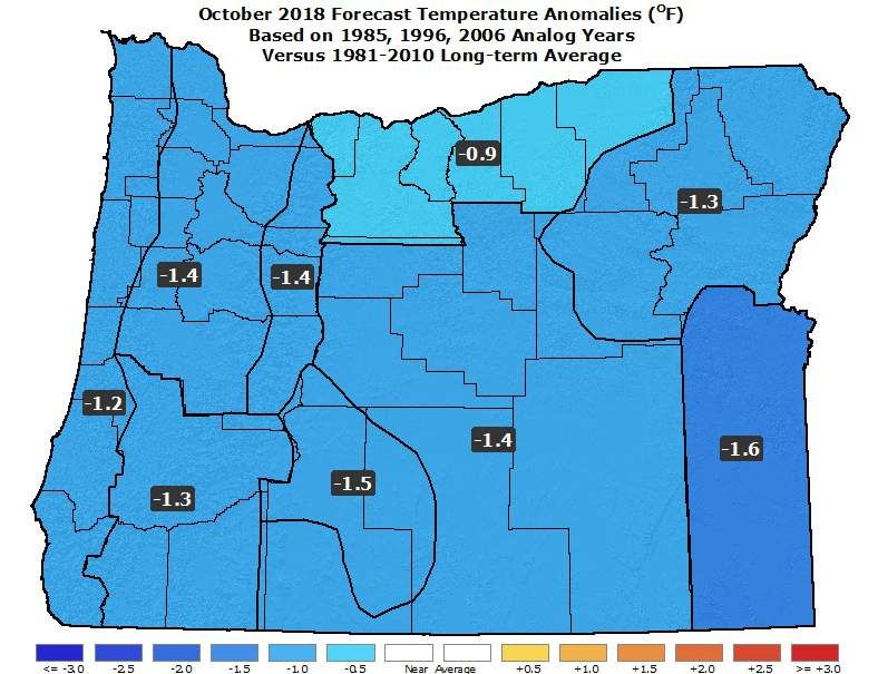
Pacific Ocean
     Animated (PowerPoint only) SSTs (top) / Anomalies (bottom)

                       Central and eastern tropical Pacific SSTs
                        have warmed to mostly above average.

Courtesy: http://www.cpc.ncep.noaa.gov/products/analysis_monitoring/enso_update/gsstanim.shtml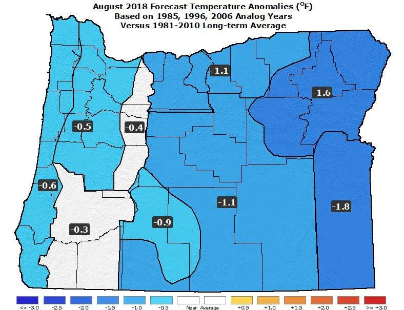
Tropical Pacific Ocean
                            Currently ENSO-neutral

     Central and eastern
    Pacific SSTs are mostly
    slightly above average

Courtesy: http://www.cpc.ncep.noaa.gov/products/analysis_monitoring/enso_update/sstweek_c.gif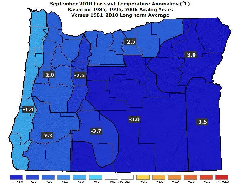
ENSO Predictive Models
           Includes both dynamic and statistical model predictions

         Strong El Niño
         Moderate
         Weak
                  ENSO-neutral

         Weak                       Computer model predictions favor the
         Moderate                    development of El Niño this fall and
                                   winter…ranging from ENSO-neutral to a
         Strong La Niña                       strong El Niño

“Base” Graphic Courtesy: http://iri.columbia.edu/our-expertise/climate/forecasts/enso/current/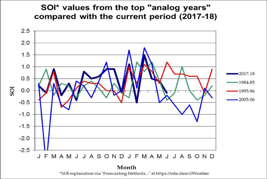
Tropical Pacific Ocean
                                 Apr – Jun
(1984-85; 1995-96; 2005-06)    ONIs of the
                               analog years
  Strong   El Niño             ranged from
                              ENSO-neutral
  Moderate                      to La Niña
  Weak

      ENSO-neutral

  Weak
  Moderate                    Apr - Jun 2018
  Strong   La Niña              ONI was
                              ENSO-neutral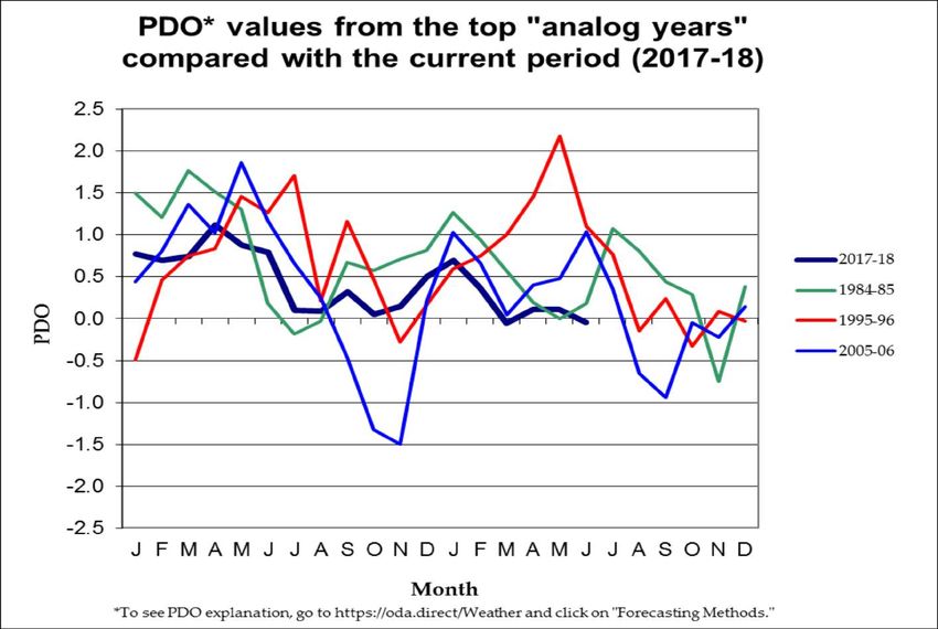
Tropical Pacific Ocean

(1984-85; 1995-06; 2005-06)    Analog years
                              had June SOIs
                              ranging from
La Niña                         La Niña to
                              ENSO-neutral

  ENSO-neutral
                              June 2018 SOI
                               was ENSO-
El Niño                          neutral
North Pacific Ocean

   (1984-85; 1995-96; 2005-06)    June PDO for
                                 the analog years
                 Warm              ranged from
                                 warm to neutral

Neutral

                                 June 2018 PDO
                 Cool              was neutral
August 2018 Forecast
Mean Upper-Air Pattern Upper-Air Anomalies
n Small negative anomalies over the Rockies and positive anomalies just
off the coast would result in more westerly flow aloft than average.
n This pattern would yield slightly stronger onshore flow than usual,
likely keeping temperatures moderate.August 2018 Forecast
Temperatures Precipitation
n Temperatures may start out warm but finish near or below average.
n Below-average precipitation.
n Periods of excessive heat are unlikely, with the warmest weather early.September 2018 Forecast
Mean Upper-Air Pattern Upper-Air Anomalies
n Significant variation in analog solutions lowers forecast confidence.
Strong anomalous troughing in 1985, and weaker troughing in 1996,
skews the composite graphics cold. However, 2006 had weak ridging.
n The September forecast may need updating next month. Stay tuned…September 2018 Forecast
Temperatures Precipitation
n 1985 and 1996 stayed on the cold side of ENSO-neutral and were
colder and wetter than average. 2006 went into El Niño during the
autumn and was relatively dry and mild.
n An analog update may be needed next month.October 2018 Forecast
Mean Upper-Air Pattern Upper-Air Anomalies
n The analog years are fairly consistent is showing anomalous ridging
somewhere in the Gulf of Alaska and troughing near the western US.
n A blend of the analog years (shown above) favors cooler and perhaps
wetter-than-average conditions for Oregon, especially west.October 2018 Forecast
Temperatures Precipitation
n A blend of the analog years favors below average temperatures,
especially late, and above average precipitation, mainly west.
n 2006 was significantly more mild and dry than the other analog years,
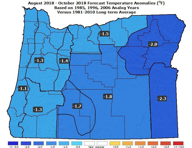
which slightly lowers forecast confidence.August – October 2018 Forecast
Mean Upper-Air Pattern Upper-Air Anomalies
n The analog years all had anomalous upper-level ridging in the Gulf of
Alaska. 1985 and 1996 had downstream troughing over the Pac NW,
but 2006 had the pattern shifted eastward, with troughing over the NE
US. A blend (shown above) favors more troughing over the Pac NW.August – October 2018 Forecast
Temperatures Precipitation
n A blend of the analog years favors anomalous troughing over the Pacific
Northwest, which would bring “relatively” cool and damp weather.
n Note: CPC’s forecast (link on next slide) favors relatively warm, and in
some areas, continued dry weather. Reviewing both forecasts is prudent.Forecast Resources n CPC Official US Three-Month Forecasts (Graphics): http://www.cpc.ncep.noaa.gov/products/predictions/long_range/seasonal.php?lead=01 n CPC US 30-Day & 90-Day Forecasts (Discussions): http://www.cpc.ncep.noaa.gov/products/predictions/long_range/fxus07.html n CPC Weekly & Monthly ENSO Discussions: http://www.cpc.ncep.noaa.gov/products/analysis_monitoring/enso_advisory n Australian Government Weekly Tropical Climate Note: http://www.bom.gov.au/climate/tropnote/tropnote.shtml n Australian Government ENSO Wrap-Up: http://www.bom.gov.au/climate/enso n IRI ENSO Quick Look: http://iri.columbia.edu/our-expertise/climate/forecasts/enso/current/ n ODA Seasonal Climate Forecast Home: http://www.oregon.gov/ODA/programs/NaturalResources/Pages/Weather.aspx
Water Supply Information
n   NDMC U.S. Drought Monitor:
http://droughtmonitor.unl.edu/

n   NIDIS North American Drought Portal:
http://www.drought.gov/nadm/content/percent-average-precipitation

n   NRCS Snow Water Equivalent Oregon Map:
http://www.wcc.nrcs.usda.gov/ftpref/data/water/wcs/gis/maps/or_swepctnormal_update.pdf

n   NRCS Snow Water Equivalent Products:
http://www.wcc.nrcs.usda.gov/snow/snotel-wereports.html

n   NRCS Weekly Water and Climate Update:
http://www.wcc.nrcs.usda.gov/cgibin/water/drought/wdr.pl

n   NRCS Western Snowpack Data & Water Supply Forecast:
http://www.wcc.nrcs.usda.gov/cgibin/westsnowsummary.pl

n   WRCC WestWideDroughtTracker:
http://www.wrcc.dri.edu/wwdt/
Updated Monthly
               (Around the 20th)

    Your Feedback is Welcome!
  Sign-up for Email Notification of updates at:
         https://oda.fyi/SubscribeSCF
    Contact: Pete Parsons, ODF Meteorologist
at 503-945-7448 or peter.gj.parsons@oregon.gov
You can also read