The Danish National Water Resources Model (DK-model) - BGR
←
→
Page content transcription
If your browser does not render page correctly, please read the page content below
IHME workshop, Berlin, 22-23. August 2013

 The Danish National Water
Resources Model (DK-model)
     - Support for decision making
       and WFD implementation

       Anker Lajer Højberg & Klaus Hinsby

     Geological Survey of Denmark and Greenland
    Danish Ministry of Climate, Energy and Building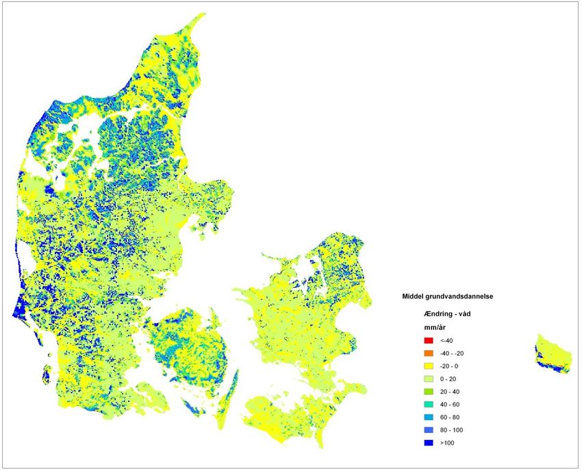
The National Water Resources
                 Model (DK-model)
                                              60                                       man3
  • Numerical hydrological
                                              50

                                              40

    model
                                              30

                                              20

                                              10

                                              0             DK-model concept
                                              -1 0

                                              -2 0

        – 43,000      km2,
                         7 sub-models         -3 0

                                              -4 0
                                                           MIKE SHE/MIKE
                                                          Abstractions:        11
                                                                           > 40.000        screens
                                              -5 0
                                                                3D groundwater
        – Coupled SW-GW model                 -6 0

                                              -7 0
                                                          Head Rivers
                                                                 obs: > 30.000 (not all time series)
          (MIKE SHE/MIKE 11)                  -8 0

                                                                Root zone
                                                          Climate    data(built into root zone module)
                                              -9 0

                                                                Irrigation
        – Data from national databases
                                                            0        500 0    100 00   150 00    200 00     250 00      300 00       350 00

        – Hydrogeological description                     River Snow
                                                                 discharge:~ 200 stations
                                                     60
                                                            Flow model
                                                                    500 m grid
                                                     50

            – 3D geological interpretation           40

                                                                    12 – 15 vertical layers
                                                     30

        – Inverse calibration - PEST
                                                     20

                                                            Daily time steps
                                                     10

                                                     0

                                                     -1 0

        – Public accessible                          -2 0

                                                     -3 0

           – Stored in national model
                                                     -4 0

                                                     -5 0

              database
                                                     -6 0

                                                     -7 0

                                                     -8 0

                                                     -9 0

                                                                0     500 0   100 00   150 00   200 00    250 00     300 00      350 00

(Højberg et al., 2013; Stisen et al., 2012)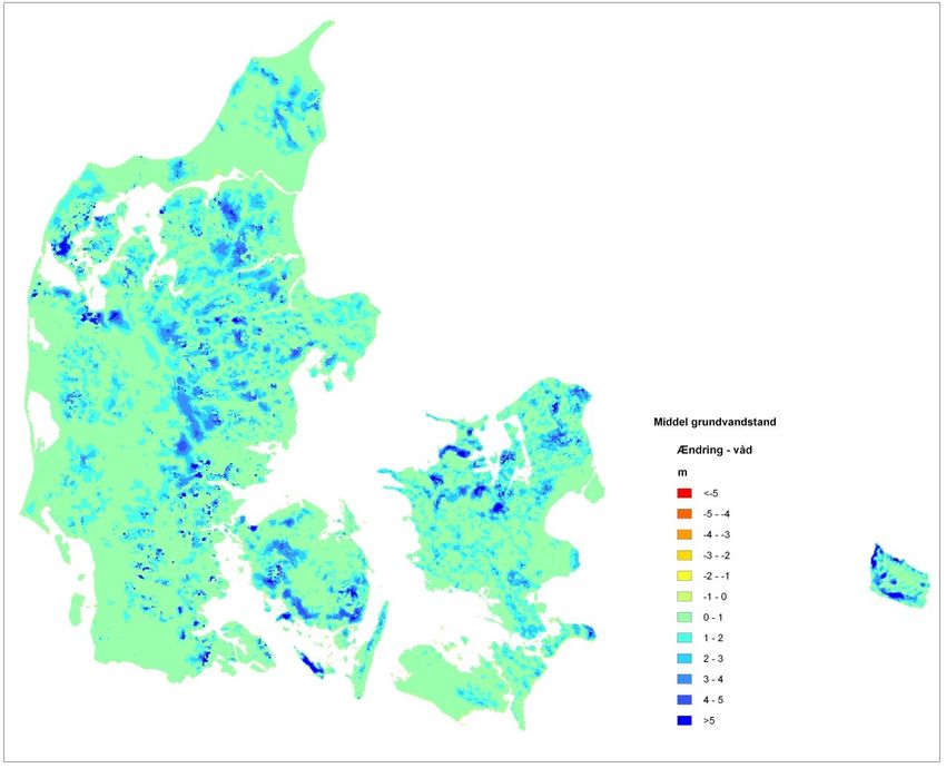
Vision
• DK-model – unifying platform
  – Hydrological model and database
  – Reference for all water management related
    aspects at all levels
• Regularly update as new knowledge and data
  becomes available
• Continuous development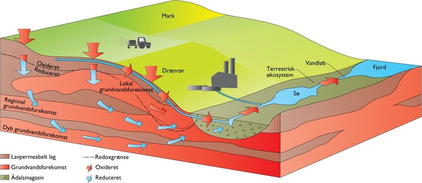
History
• 1996 – 2003: 1. version of the DK-model      (Henriksen et al., 2003)

   o Improved estimate of the national water balance (replacing
     simple analytical estimate)
   – Research project
   – National interpretations
   – National databases

• 2005 – 2009: Extensive model
  update (Højberg et al., 2013)
   – Collaboration with regional water
     authorities
   – Regional and local studies (> 50)

• 2010 – 2013: Various improvements based on national,
  regional and local scale studies
   – New geological models funded by the Danish Nature Agencies
     must be prepared for inclusion in DK-model
   – Collaboration between GEUS, water authorities and
     consultancies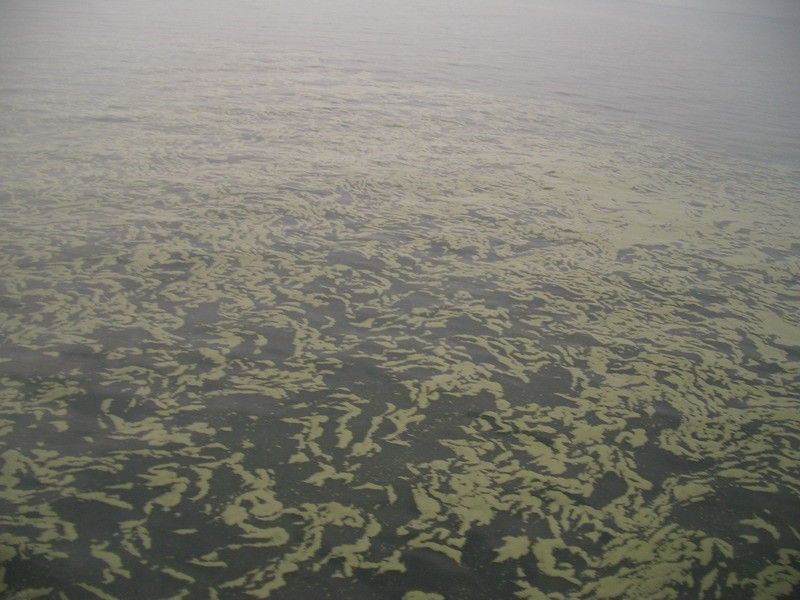
Model applications
                              Climate change
                          impacts and adaptions
                    Quantitative                    Chemical
                       status                         status
                   Groundwater                    Groundwater
                   Surface water                  Surface water

      Applications                                 Users
      •   WFD/GWD implementation                   •   Research institutions
      •   National & regional assessments          •   National water authorities
      •   Basis for local studies                  •   Regional authorities
      •   Research projects                        •   Municipalities
                                                   •   Water companies

~25 SCI listed papers since 2003, directly or indirectly based on the DK-model (> 2 per year)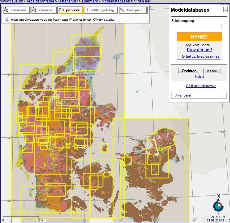
The DK-model in WFD implementation
 Groundwater quantitative                                            Groundwater chemical status
 status e.g.:                                                        e.g.:

 1)       Aquifer safe yield (Henriksen et al., 2008)                1)         Threshold values to protect
 2)       Eflows (flow quantity and quality                                     terrestrial ecosystems
          required to sustain surface water                          2)         Threshold values to protect aquatic
          ecosystems) (Olsen et al., 2012)                                      ecosystems and e.g. reduce risk of
 3)       Terrestrial ecosystems                                                harmful algal blooms (Hinsby et al., 2008,
                                                                                2012)
 4)       Flooding risks (coastal and
                                                                     3)         Saltwater intrusion. (Rasmussen et al., 2013)
          hinterland) (Sonnenborg et al., 2012)
                                          Harmful Algal Bloom (Cyanobacteria)
                                      Baltic Sea between Denmark and Germany –
                                                          25.8.2006

(Sonnenborg et al., 2012)           Foto: Klaus Hinsby, GEUS (Hinsby et al., 2008)                        (Hinsby et al., 2012).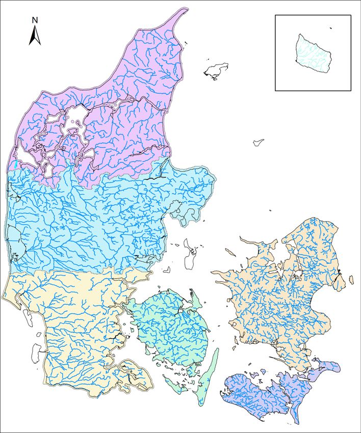
Quantitative status
             Integrated national assessment
                                                                      Henriksen et al., 2008

                                                Climate variability

Decreased groundwater table:
Extraction related to natural recharge

   Increased deep recharge
                                                Reduced streamflow:
                                                Mean flow
                                                Eflow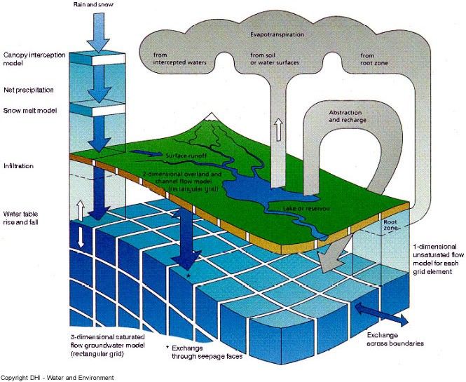
Monitoring programme
• Conceptual hydrogeological model -> 3D
  delineation of GW bodies and link to national
  database on quantity and quality
   – Basis for reporting to EU
• Design of GW monitoring programme
• Estimates of water balance – quantitative status

                                                  DK-model
                                        Corrected DK-model
• Interpolation                                   Observed

  and extra-
                  Q (mm/day)

  polation of
  freshwater
  discharges

                                               Windolf et al., 2007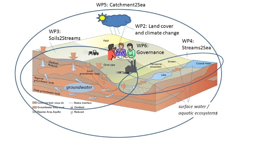
Calculations of climate change effects on
      hydrology and groundwater

  Present
  Climate                                                       Change in shallow gw-level
                                                                (m)
                                                                      2

                                     scaling
                                       Bias
                                    Correction
  Future
  Climate

              Global     Regional                Hydrological                                Models

            100-250 km   10-25 km                 50-500 m                                   Skala

 Several regional studies to estimate effects of CC and
 uncertainty related to the simulations
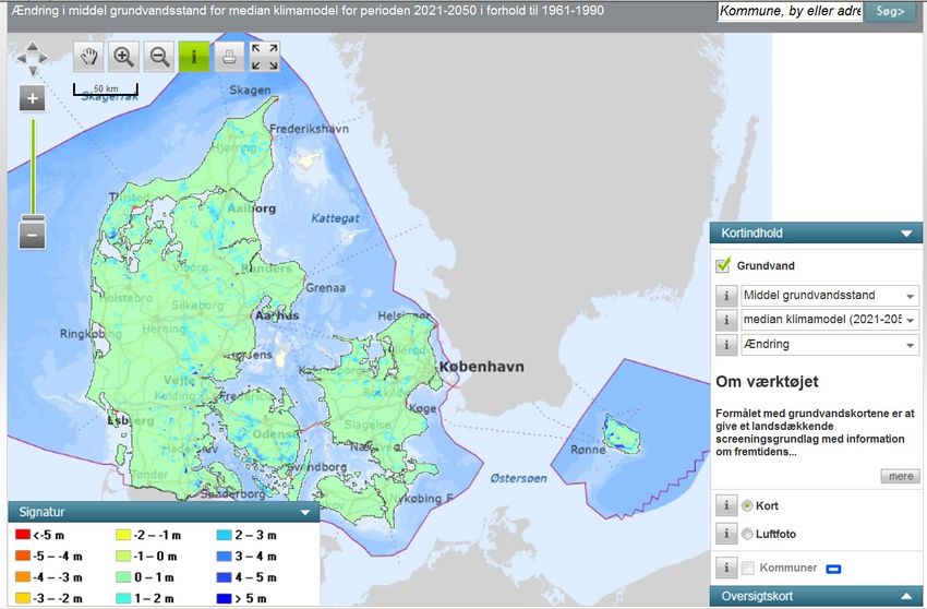
Risk for GW flooding or reduced recharge
Min, mean and max changes in GW levels based on analysis of 9 GCMRCM combinations

Groundwater level 2021-2050 versus 1961-1990   Groundwater recharge 2021-2050 versus 1961-1990
Changes in meter                               Changes in mm/year                       10
Results available from public portal
  Changes in extreme flow
       Climate factors, Qmax, T=100 year

                                           11
CC effects on N-mass fluxes
Predicted future N-
flux (A2 emission
CC will scenario)
generally
increase
stream
flow
Observed N-
flux as function
of discharge
Increasing precipitation and runoff
will increase nutrient loads– and
hence require reduced groundwater
threshold values (assuming no land
use change) (Sonnenborg et al., 2011)Present studies:
Nitrogen load to coastal areas
Development of model complex (DSS). Collaboration between
national research institutes
N-leaching
Danish Centre for Food
and Agriculture (DCA) Surface
water
Danish Centre
for Environment
Groundwater and Energy
GEUS (DCE)
Basis for implementation of the WFD – 2nd cycle Funded by
• Estimates of nitrate load to Fjords and marine areas • Danish Nature Agency
• Danish Environmental
• Estimate reduction in GW and surface water systems Agency
• Locate optimal mitigation measures and location • Danish AgriFish
Agency
• Estimate effect of mitigation measuresNew BONUS research project ”Soils2Sea” Partners from: DK (coordinator), DE, PL, RU and SE Topic: reduction of nutrient loadings to the Baltic Sea and the impacts of climate change.
Selected references directly or indirectly using the DK-model
      Hansen AL, Refsgaard JC, Christensen BSB, Jensen KH (2013), Water Resources Research 49: 585-603 DOI 10.1029/2011wr011783
      Hansen JR, Refsgaard JC, Ernstsen V, Hansen S, Styczen M, Poulsen RN (2009), Hydrology Research 40: 347-363 DOI 10.2166/nh.2009.035
      Henriksen HJ, Refsgaard JC, Hojberg AL, Ferrand N, Gijsbers P, Scholten H (2009) Water Resources Modelling. Water Resources Management 23:
                 2539-2554 DOI 10.1007/s11269-008-9395-9
      Henriksen HJ, Troldborg L, Hojberg AL, Refsgaard JC (2008) Journal of Hydrology 348: 224-240 DOI 10.1016/j.jhydrol.2007.09.056
      Henriksen HJ, Troldborg L, Nyegaard P, Sonnenborg TO, Refsgaard JC, Madsen B (2003). Journal of Hydrology 280: 52-71 DOI 10.1016/s0022-
                 1694(03)00186-0
      Hinsby K, de Melo MTC, Dahl M (2008). Science of the Total Environment 401: 1-20
      Hinsby K, Markager S, Kronvang B, Windolf J, Sonnenborg TO, Thorling L (2012). Hydrology and Earth System Sciences 16: 2663-2683 DOI
                 10.5194/hess-16-2663-2012
      Hojberg AL, Troldborg L, Stisen S, Christensen BBS, Henriksen HJ (2013). Environmental Modelling & Software 40: 202-213 DOI
                 10.1016/j.envsoft.2012.09.010
      Kidmose J, Refsgaard JC, Troldborg L, Seaby LP, Escriva MM (2013). Hydrology and Earth System Sciences 17: 1619-1634 DOI 10.5194/hess-17-1619-
                 2013
      Rasmussen J, Sonnenborg TO, Stisen S, Seaby LP, Christensen BSB, Hinsby K (2012). Hydrology and Earth System Sciences 16: 4675-4691 DOI
                 10.5194/hess-16-4675-2012
      Rasmussen P, Sonnenborg TO, Goncear G, Hinsby K (2013). Hydrology and Earth System Sciences 17: 421-443 DOI 10.5194/hess-17-421-2013
      Refsgaard JC, Hojberg AL, Moller I, Hansen M, Sondergaard V (2010). Ground Water 48: 633-648 DOI 10.1111/j.1745-6584.2009.00634.x
      Seaby LP, Refsgaard JC, Sonnenborg TO, Stisen S, Christensen JH, Jensen KH (2013). Journal of Hydrology 486: 479-493 DOI
                 10.1016/j.jhydrol.2013.02.015
      Seifert D, Sonnenborg TO, Refsgaard JC, Hojberg AL, Troldborg L (2012). Water Resources Research 48 DOI 10.1029/2011wr011149
      Seifert D, Sonnenborg TO, Scharling P, Hinsby K (2008). Hydrogeology Journal 16: 659-674 DOI 10.1007/s10040-007-0252-3
      Sonnenborg TO, Hinsby K, van Roosmalen L, Stisen S (2012). Climatic Change 113: 1025-1048 DOI 10.1007/s10584-011-0367-3
      Stisen S, Hojberg AL, Troldborg L, Refsgaard JC, Christensen BSB, Olsen M, Henriksen HJ (2012). Hydrology and Earth System Sciences 16: 4157-4176
                 DOI 10.5194/hess-16-4157-2012
      Troldborg L, Jensen KH, Engesgaard P, Refsgaard JC, Hinsby K (2008). Journal of Hydrologic Engineering 13: 1037-1048 DOI 10.1061/(asce)1084-
                 0699(2008)13:11(1037)
      van Roosmalen L, Christensen BSB, Sonnenborg TO (2007). Vadose Zone Journal 6: 554-571 DOI 10.2136/vzj2006.0093
      van Roosmalen L, Christensen JH, Butts MB, Jensen KH, Refsgaard JC (2010). Journal of Hydrology 380: 406-419 DOI 10.1016/j.jhydrol.2009.11.014
      van Roosmalen L, Sonnenborg TO, Jensen KH (2009). Water Resources Research 45 DOI 10.1029/2007wr006760
      Windolf J, Thodsen H, Troldborg L, Larsen SE, Bogestrand J, Ovesen NB, Kronvang B (2011). Journal of Environmental Monitoring 13: 2645-2658 DOI
      10.1039/c1em10139k
You can also read