Seasonal Climate Forecast September - November 2015
←
→
Page content transcription
If your browser does not render page correctly, please read the page content below
Seasonal Climate Forecast
    September – November 2015
                    Issued: August 20, 2015

   A cooperative product between the Oregon
Department of Agriculture (ODA), and the Oregon
         Department of Forestry (ODF).

         Contact: ODF Meteorologist Pete Parsons
     at 503-945-7448 or peter.gj.parsons@oregon.gov
  Get related Seasonal Climate Forecast information at:
http://www.oregon.gov/ODA/programs/NaturalResources/Pages/Weather.aspx
El Niño Southern Oscillation (ENSO)
Current Status and Forecast
The Climate Prediction Center (CPC) has issued an El Niño
n
Advisory. Equatorial Pacific Ocean SSTs have continued to
warm and have entered the moderate El Niño range.
nThe current Oceanic Niño Index (ONI) is +1.0°C. The
CPC thresholds for a weak, moderate, and strong El Niño are
an ONI of +0.5°C, +1.0°C, and +1.5°C respectively.
nCPCforecaster consensus unanimously favors El Niño
becoming strong and peaking this late-fall/early-winter.
http://www.cpc.ncep.noaa.gov/products/analysis_monitoring/lanina/enso_evolution-status-fcsts-web.pdf
Forecast Method Notes… nThe top analog years (1987; 1991; 2004) used to create this forecast were all years with developing El Niño (like this summer), following a winter with positive ONI anomalies (like last winter). nThe best analog “match” to this year is 1987, but all three years were given equal weight in the forecast graphics. nThis forecast is based solely on historical weather data and does not utilize dynamic modeling (see Forecasting Methods).
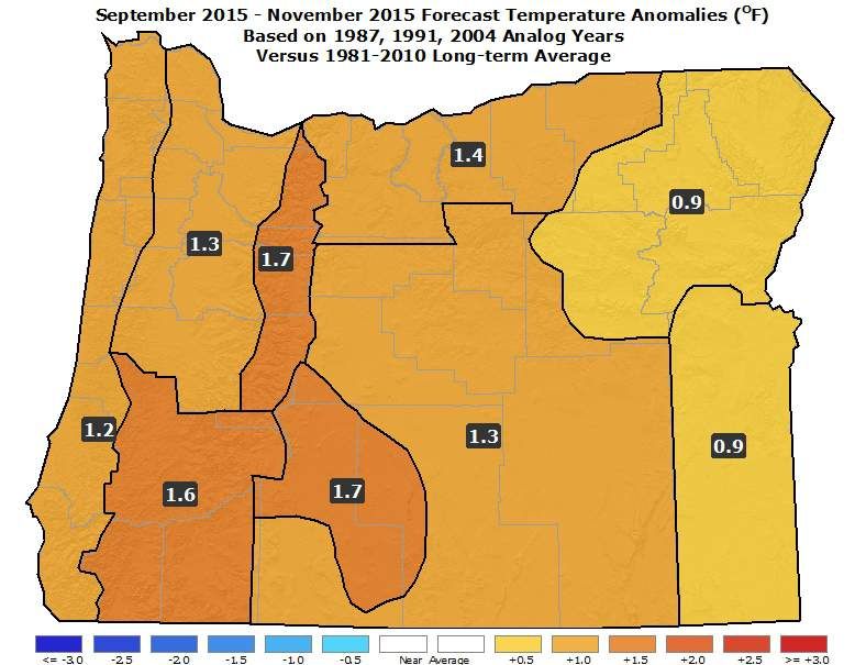
Forecast Notes of Interest… n 2015 has proven to be quite rare, in terms of Pacific Ocean SSTs. The corresponding weather patterns have been “extreme,” with Oregon experiencing record or near-record warm and dry conditions since last winter. n SST records, going back to 1950, show only one other year (1987) with an ONI for the May-June-July period of +1.0 or greater (like this year) following a winter with positive ONIs (like last winter). 1987 also exhibits the best “match” to the incredibly high PDO values of the current year. n The predicted strong El Niño for this fall/winter favors a continuation of warmer and drier-than-average weather, especially across the northern zones.
Pacific Ocean
   Animated (in PowerPoint only) SSTs (top) / Anomalies (bottom)

                Well above average SSTs extend across the eastern Gulf
                  of Alaska and most of the tropical Pacific Ocean.

Courtesy: http://www.cpc.ncep.noaa.gov/products/analysis_monitoring/enso_update/gsstanim.shtml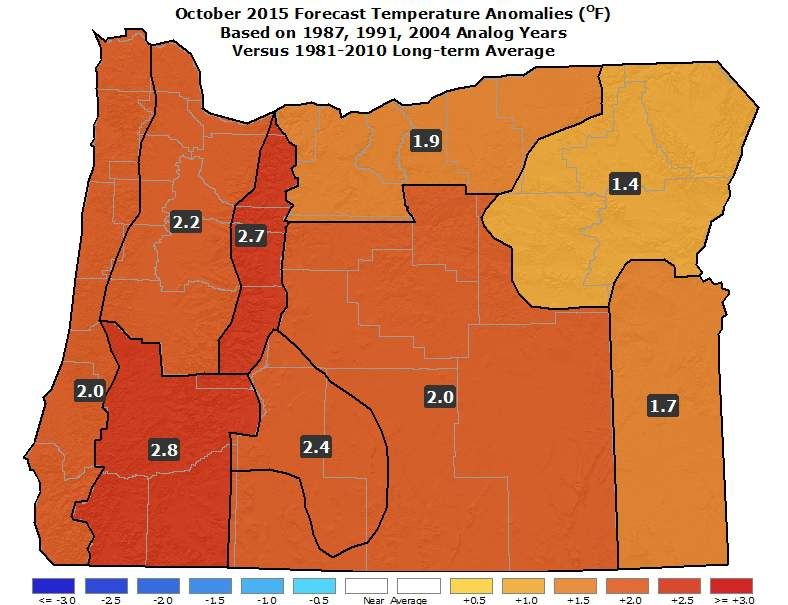
Tropical Pacific Ocean
      El Niño has strengthened into the “moderate” range...

                                     SSTs are well above average across
                                     most of the tropical Pacific Ocean

Courtesy: http://www.cpc.ncep.noaa.gov/products/analysis_monitoring/enso_update/sstweek_c.gif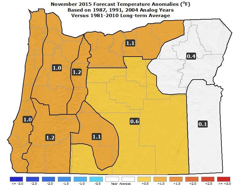
Tropical Pacific Ocean

    (2003-04; 1990-91; 1986-87)
La Niña

                                  ENSO-neutral

       Weak El Niño
     “Modoki” last winter   El Niño is currently
El Niño                       strengthening...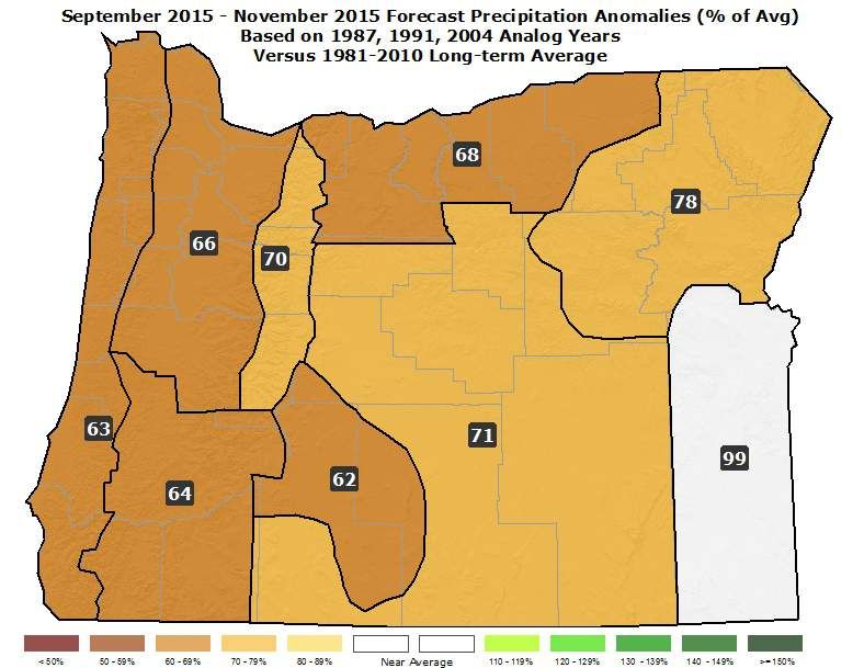
Tropical Pacific Ocean

     (2003-04; 1990-91; 1986-87)

El Niño Strong

          Moderate
ENSO-neutral

          Weak

                                     El Niño has
          Weak El Niño “Modoki” strengthened into the
                last winter.        moderate range
La Niña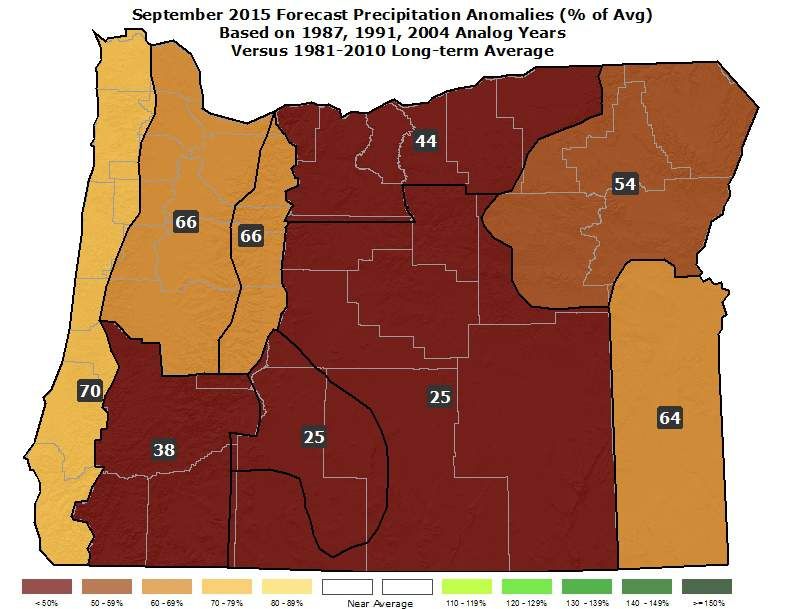
North Pacific Ocean

   (2003-04; 1990-91; 1986-87)
 Last Winter Had The Highest PDO Values Since 1997

Warm

                           Average

                                            PDO is
                                        rising again…
Cool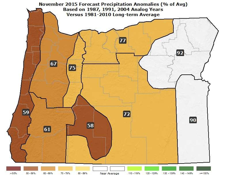
ENSO Predictive Models
  El Niño is predicted to become strong this fall and winter…

                          Model forecasts favor ENSO-neutral
                         conditions through spring 2014; followed by
                         El Niño development.

     El Niño

     ENSO-neutral

     La Niña

“Base” Graphic Courtesy: http://iri.columbia.edu/our-expertise/climate/forecasts/enso/current/
Chart Updates n A time-series graphical comparison of “PDO” values was recently added. n Predicted upper-air patterns and anomalies have also been added to help explain the reasons for the corresponding temperature and precipitation forecasts. n Precipitation forecasts have changed from “departure from average” (in inches) to “percent of average” (with 100% being average). n The color palettes have been updated for both the temperature and precipitation anomaly graphics.
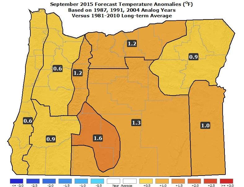
September 2015 Forecast
Mean Upper-Air Pattern Upper-Air Anomalies
n Upper-level ridging is likely to be stronger than average over the NW
US and SW Canada.
n A strengthening “split-flow” westerly jet stream is likely, which will
tend to weaken storm systems, as they approach the Oregon coast.September 2015 Forecast
Temperatures Precipitation
n Expect a continuation of above average temperatures and below
average precipitation.
n However, there is a tendency, during a moderate-to-strong El Niño, for
at least one cool and possibly damp period in September.October 2015 Forecast
Mean Upper-Air Pattern Upper-Air Anomalies
n Stronger than average upper-level ridging is likely over the NW US.
n Early-autumn storms will have a tendency to “split,” as they move
onshore, with most of their precipitation being directed north, into
Canada, and south, into California.October 2015 Forecast
Temperatures Precipitation
n Analog years suggest a continuation of generally mild and dry weather.
n This “El Niño-driven” climate signal typically becomes more evident in
the fall and winter months.
n Northern zones will likely see the driest conditions (relative to average).November 2015 Forecast
Mean Upper-Air Pattern Upper-Air Anomalies
n Anomalous upper-level ridging is predicted to be centered over
extreme SW Canada, which would weaken approaching fall storms.
n A “split-flow” jet stream pattern will likely direct considerable storm
energy south of Oregon, into California.November 2015 Forecast
Temperatures Precipitation
n No major change - continued generally warmer and drier than average.
n It is possible that the number of days with rain/snow will be near
average but with decreased precipitation totals.
n The likelihood of valley fog episodes is elevated.September – November 2015 Forecast
Mean Upper-Air Pattern Upper-Air Anomalies
n Strong anomalous upper-level ridging is predicted to be centered just
off the southern BC coast.
n Expect a “split-flow” jet stream pattern to emerge and strengthen, with
storm systems spreading apart, as they approach the Oregon coast.September – November 2015 Forecast
Temperatures Precipitation
n An El Niño in the tropical Pacific Ocean typically yields warmer and
drier-than-average weather for Oregon during the autumn season.
n However, significant cool periods are possible, including brief early-
season Arctic outbreaks.Forecast Resources n CPC Official US Three-Month Forecasts (Graphics): http://www.cpc.ncep.noaa.gov/products/predictions/long_range/seasonal.php?lead=01 n CPC US 30-Day & 90-Day Forecasts (Discussions): http://www.cpc.ncep.noaa.gov/products/predictions/long_range/fxus07.html n CPC Weekly & Monthly ENSO Discussions: http://www.cpc.ncep.noaa.gov/products/analysis_monitoring/enso_advisory n Australian Government Weekly Tropical Climate Note: http://www.bom.gov.au/climate/tropnote/tropnote.shtml n Australian Government ENSO Wrap-Up: http://www.bom.gov.au/climate/enso n IRI ENSO Quick Look: http://iri.columbia.edu/our-expertise/climate/forecasts/enso/current/ n ODA Seasonal Climate Forecast Home: http://www.oregon.gov/ODA/programs/NaturalResources/Pages/Weather.aspx
Water Supply Information n NDMC U.S. Drought Monitor: http://droughtmonitor.unl.edu/ n NIDIS North American Drought Portal: http://www.drought.gov/nadm/content/percent-average-precipitation n NRCS Snow Water Equivalent Oregon Map: http://www.wcc.nrcs.usda.gov/ftpref/data/water/wcs/gis/maps/or_swepctnormal_update.pdf n NRCS Snow Water Equivalent Products: http://www.wcc.nrcs.usda.gov/snow/snotel-wereports.html n NRCS Weekly Water and Climate Update: http://www.wcc.nrcs.usda.gov/cgibin/water/drought/wdr.pl n NRCS Western Snowpack Data & Water Supply Forecast: http://www.wcc.nrcs.usda.gov/cgibin/westsnowsummary.pl n WRCC WestWideDroughtTracker: http://www.wrcc.dri.edu/wwdt/
Updated Monthly
                    (around the 20th)

                                 Your Feedback
                                  is Welcome!

      Contact: Pete Parsons, ODF Meteorologist
  at 503-945-7448 or peter.gj.parsons@oregon.gov
ODA Production support from Diana Walker and Andy Zimmerman
You can also read