DOST-PROJECT NOAH El-Nino - AMF Lagmay
←
→
Page content transcription
If your browser does not render page correctly, please read the page content below
DOST-PROJECT NOAH
      El-Nino
    AMF Lagmay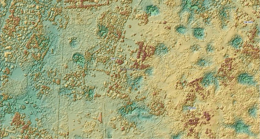
Consequences of El Niño
• El Niño is a disruption of the ocean-
  atmosphere system in the Tropical
  Pacific having important consequences
  for weather and climate around the
  globe.
Sendong
disaster Iligan

   UP NIGS team
DOST PROJECTS UNDER PROJECT NOAH

    In response to President Aquino’s instructions
      to put in place a responsive program for:

   1) flood mitigation, specifically targeting a 6
      hour flood early warning system for
      communities along 18 major river systems;
   2) enhancement of geohazard maps and;
   3) enhancement of storm surge vulnerability
      maps

           the DOST is presenting the
     Nationwide Operational Asessment of
                     Hazards

  DEPARTMENT OF SCIENCE AND TECHNOLOGY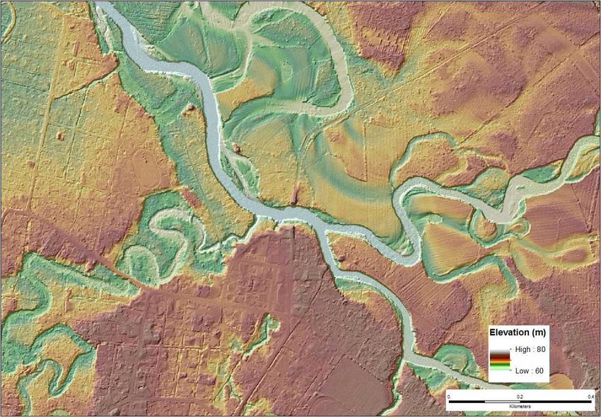
DOST PROGRAMS UNDER THE NOAH PROGRAM

                                Project NOAH

 HydroMetDREAM-LIDARFloodNET
                          Hazard Information
                                           Landslides Doppler System Storm Surge
  Sensors                       Media         and      Development
                                          Geohazards
Developmen
     t

                Coastal
                 Landslides
                   Doppler
              Hazard
              HydroMet  Erosion
                     Information
                        Sensors
                   FloodNET
                 DREAM-LIDAR
               and
               and Geohazards
                   System
                   Storm
                    Media Surge
                 Development
                Development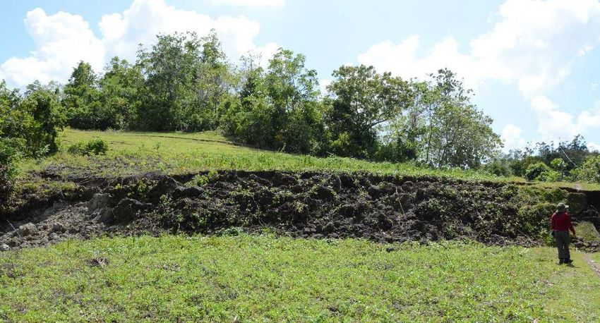
• The difference between weather
  and climate is a measure of time.
  Weather is what conditions of the
  atmosphere are over a short period
  of time, and climate is how the
  atmosphere "behaves" over
  relatively long periods of time. Source:
 http://www.nasa.gov/mission_pages/noaa-n/climate
PAGASA has been closely monitoring
the oceanic and atmospheric
conditions in the tropical Pacific that
could lead to possible development
of an El Niño. A majority of climate
models indicate that El Niño may
develop this year. El Niño is
characterized by unusually warm
ocean surface temperatures in the
central and eastern equatorial
Pacific (CEEP).
The sea surface temperature anomaly (SSTA)
over the tropical Pacific remained to be El Niño
Southern Oscillation (ENSO)- neutral during
the past several months. The established
threshold of SSTA for an El Niño phenomenon
is 0.5°C or higher during a three-month
period.
PAGASA has already noted significant
increase in the SSTA from 0.2 to 0.4°C
from April 21 to April 28, 2014. Because of
this development and as climate models
predict that this condition may persist for
the next nine months, PAGASA is
foreseeing the onset of El Niño in June
which may peak during the last quarter of
2014 and may last up to the first quarter
of 2015.
El Niño could affect the normal rainfall
pattern in the country generally resulting in
reduced rainfall. Different parts of the
country may experience varying rainfall
impacts. PAGASA will be furnishing monthly
rainfall outlook for six months for the
different parts of the country.
The country could still experience normal
number of tropical cyclone this year.
However, El Niño causes the behavior of
tropical cyclones to become erratic,
affecting its tracks and intensity. The
tropical cyclone tracks are expected to shift
northward and its intensity could become
stronger.
Superimposed tracks of typhoons
                                                              15
                            that entered PAR from 1951-2013
PAR – Philippine Area of Responsibility
PAGASA will continue to closely monitor the tropical Pacific and updates/advisories shall be issued as appropriate. Concerned agencies are advised to take precautionary measures to mitigate the potential impacts of this phenomenon. MARIO G. MONTEJOSecretary, DOST
HYDROMET SENSORS

 More than 1000
 automated rain
 gauges (ARG),
 automated stream
 gauges (ASG) and
 automated weather
 stations (AWS)
HYDROMET SENSORS

                   Tropical Storm Gorio
19
Cloud Trail Code: Radar Images for September 19, 2012 10:00 UTC to 13:00 UTC

                                                                     3
Cloud Trails from Accumulation
September 19, 2012 10:00 UTC to 13:00 UTC
3Longer eigenvector (major axis of approximate ellipse)
34-hour forecasted images (by advection)
3Radar images and forecast images
3Pinatubo
Balikabo
k
Natib
Marivele
sPinatubo
Natib
a y
a B
n il
Ma
Marivele
sSample satellite-
derived maps
• 8-day maps AA B
a. NDVI
b. LST
c. Soil Moisture
d. Precipitation
• Maps can also
be produced as
C D
10-day, monthly,
seasonal, and
annual
composites for
all parametersNew Technologies IBM Blue Gene supercomputer • Generate 7-day weather forecast at 3 kilometer resolution • Update the forecast every 3 hrs
1.5 km model versus satellite imagery
                       every 3 hours

                                        Simulate
                                        d

                                        Satellite
Examples
Forecast volume of
Rainfall in millimeters
accumulated rainfall
over 24 hours per
watershed to give a
flood warning lead
time by at least a
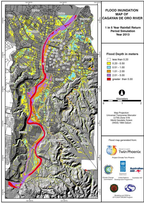
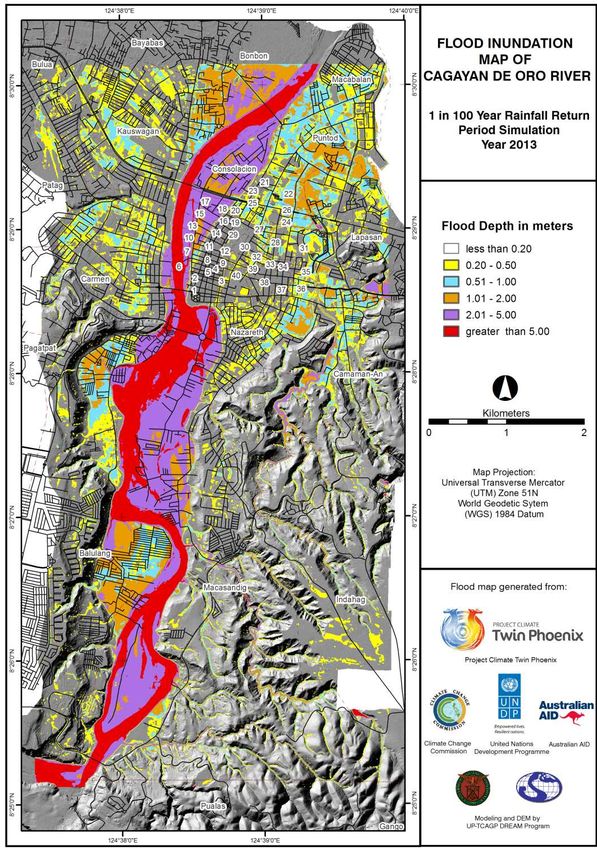
day.Proposed Flood Advisory System
190mm rainfall in 24hrs 240mmExamples
129mm rainfall in 24hrs rainfall in
24hrs
Flood Flood Flood
Advisory Advisory Advisory
#1 #2 #3
33Examples
Storm surge
Storm surge height in cm
forecasts at least 2
days in advance;
Typhoon track,
strength, warnings,
days in advanceExamples Events planning; hydropower; transport planning; business planning; general weather
Examples
Agricultural
planning;
reservoir control;
energy;
commerce; state
planning,
drought, etc.
Examples
                12
                10
Rainfall (mm)

                8
                6
                4
                2
                0
Examples
Rainfall
forecast with
millimeters
climate change
projections for
each
watershedUS NOAA’s Seamless Suites of
Products
Automated rainfall
now-casting (every
15 minutes) for up
to 4 hours ahead
-Project
Source: NOAA NCEP NOAH/Climate-XUS NOAA’s Seamless Suites of
Products
Hourly weather
forecast up to 7
days ahead
PAGASA, Proj.
Source: NOAA NCEP
NOAH-WISEUS NOAA’s Seamless Suites of
Products
Seasonal forecast (i.e.
daily: for up to 30 days
ahead and weekly: for 1- to
6- months ahead)
UK Unified Model
subscribed by DOST-
Source: NOAA NCEP
Project NOAHUS NOAA’s Seamless Suites of
Products
Interannual
and decadal
outlook
(PAGASA &
UK Unified
Models)
Source: NOAA NCEPUS NOAA’s Seamless Suites of
Products
Climate
projections
Now 25 km
downscaled to
8 km (PAGASA
& UK Unified
Source: NOAA NCEP
models)UK Met office
NOW
2008 2009 2010 2011 2012 2013 2014 2015 2016LIDAR
LIDAR
AR Compostela Municipality Town Proper
AR Compostela Municipality Town Proper
nity scale maps, development planning, emergency p
53
Barangay level landslide hazard map

                                       54
Department of Science and Technology
Superimposed tracks of typhoons
57
that entered PAR from 1951-2013
PAR – Philippine Area of ResponsibilityUN
AVENUE
MALATE
58
Storm surge (1.8 m height Typhoon Pedring) - inundation map for ManilaA hundred years
from now, during
2010
2110
2060
high tide, large
parts of Navotas
will be 4 meters
underwater and
Manila under 2
meters of water.
Flood Depth
(m)
60DOST
Currently
PROJECT
available
NOAH
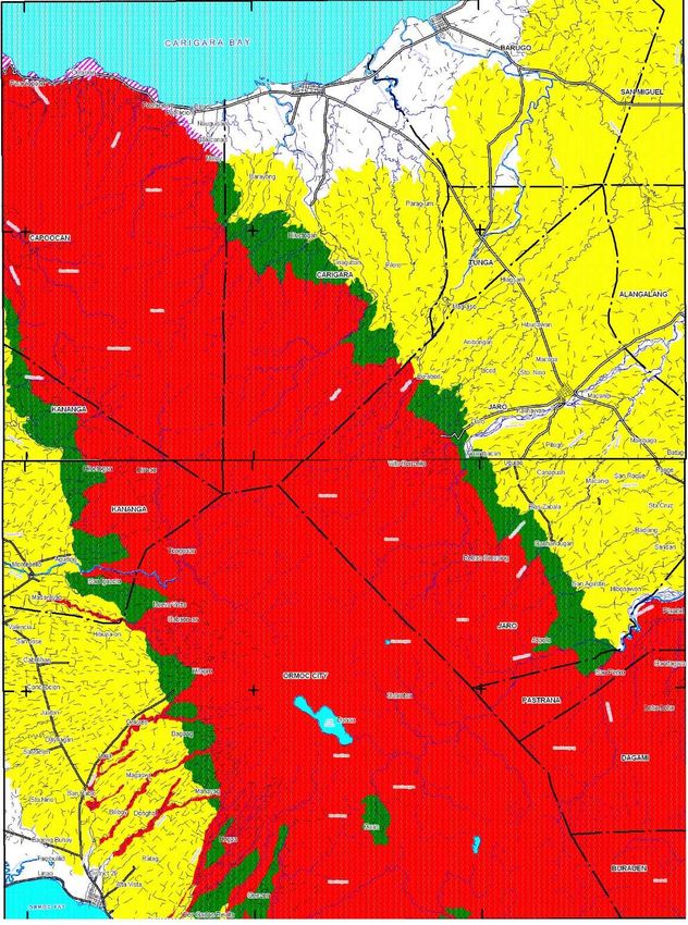
Landslide
LANDSLID
Hazard
E HAZARD
Map
MAP
for
Northern
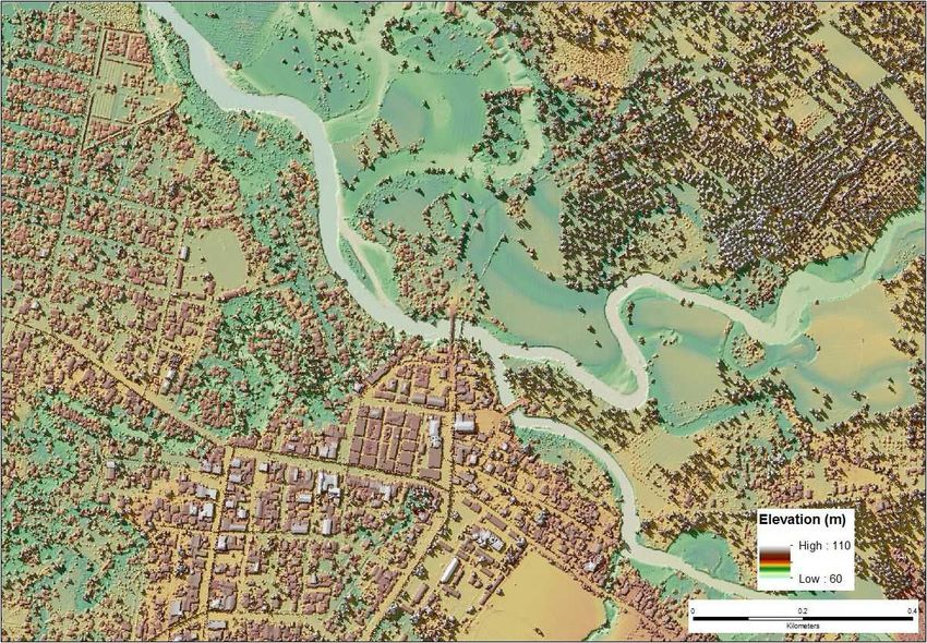
LeyteIFSAR DIGITAL ELEVATION MODEL
SHALLOW LANDSLIDES
LANDSLIDE INVENTORIES
TRUCTURALLY CONTROLLED LANDSLIDES
BARANGAY BORDER
POSSIBLE LANDSLIDE EXTENTS
Landslide
Hazard Type Current map
Enhanced map
High 62.53%
28.34%
Moderate 10.54%
19.91%
Low 20.61%
4.22% 62
Department of Science and Technology
Safe 6.32%PHILIPPINE UNIVERSITIES’ SCIENCE OBSERVER
You can also read